River in China
| Songhua River
|
|---|
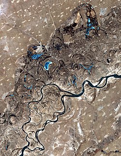 Songhua River, just west of Harbin.
Oxbow lakes
are common sights along the sides of the river.
|
| Native name
| |
|---|
|
| Country
| People's Republic of China
|
|---|
| Provinces
| Jilin
,
Heilongjiang
|
|---|
|
|
| Source
| Changbai Mountains
|
|---|
| • location
| Antu County
, Jilin
|
|---|
| • coordinates
| 42°02′06″N
128°16′37″E
/
42.035°N 128.277°E
/
42.035; 128.277
|
|---|
| • elevation
| 1,412 m (4,633 ft)
|
|---|
|
|
| Mouth
| Amur
|
|---|
• location
| Tongjiang
, Heilongjiang
|
|---|
• coordinates
| 47°41′56″N
132°31′03″E
/
47.699°N 132.5176°E
/
47.699; 132.5176
|
|---|
• elevation
| 44 m (144 ft)
|
|---|
| Length
| 1,897 km (1,179 mi)
[1]
|
|---|
| Basin size
| 557,180 km
2
(215,130 sq mi)
[2]
|
|---|
|
| Discharge
|
|
|---|
| • location
| Tongjiang
,
China
(near mouth)
|
|---|
| • average
| 76.2 km
3
/a (2,410 m
3
/s) to 81.77 km
3
/a (2,591 m
3
/s).
[3]
[1]
|
|---|
|
|
|
| Progression
| Amur
→
Sea of Okhotsk
|
|---|
| River system
| Amur
|
|---|
| Tributaries
|
|
|---|
| • left
| Nen
,
Hulan
, Tangwang
|
|---|
| • right
| Mudanjiang
|
|---|
The
Songhua
or
Sunghwa River
(also
Haixi
or
Xingal
,
Russian
:
Сунгари
Sungari
) is one of the primary
rivers of China
, and the longest
tributary
of the
Amur
. It flows about 1,897 km (1,179 mi)
[1]
from
Changbai Mountains
on the
China?North Korea border
through China's northeastern
Jilin
and
Heilongjiang
provinces.
The river drains 557,180 km
2
(215,130 sq mi) of land, and has an annual discharge of 76.2 km
3
/a (2,410 m
3
/s) to 81.77 km
3
/a (2,591 m
3
/s).
[4]
[1]
[2]
The extreme flatness of the
Northeast China Plain
has caused the river to
meander
over time, filling the wide plain with
oxbow lakes
, as remnants of the previous paths of the river.
Geography
[
edit
]
The Songhua rises south of
Heaven Lake
, near the
China
-
North Korea
border.
[
citation needed
]
From there it flows north, to be interrupted by the
Baishan
,
Hongshi
and
Fengman
hydroelectric
dams. The Fengman Dam forms a lake that stretches for 62 kilometers (39 mi). Below the dam, the Second Songhua flows north through
Jilin
, then northwest until it is joined by its largest tributary, the
Nen River
, near
Da'an
, to create the Songhua proper.
The Songhua turns east through
Harbin
, and after the city, it is joined from the south by the
Ashi River
, and then by the
Hulan River
from the north.
A new dam was constructed in 2007 near
Bayan
(50 km northeast of
Harbin
), creating the Dadingshan Reservoir,
[5]
which is named after the scenic area on the south bank (
Chinese
:
大頂山
;
pinyin
:
dad?ngsh?n
;
lit.
'Big Topped Mountain').
The river flows onward through
Jiamusi
and south of the
Lesser Xing'an
Range, to eventually join the Amur at
Tongjiang, Heilongjiang
.
The river freezes from late November until March. It has its highest flows when the mountain snow melts during the spring thaw. The river is
navigable
up to Harbin by medium-sized ships. Smaller craft can navigate the Songhua up to
Jilin
and the Nen River up to
Qiqihar
.
Cities along the river include:
History
[
edit
]
 Vendors on frozen Songhua
In November 2005, the river was
contaminated with benzene
, leading to a shutdown of Harbin's water supply.
[
citation needed
]
The spill stretched 80 kilometers (50 mi) and eventually reached the Amur (Heilong) River on the
China?Russia border
.
[6]
On July 28, 2010, several thousand barrels from two chemical plants in China's Jilin City were washed away by
floods
. Some of them contained 170 kilograms (370 lb) of explosive material like
trimethylsilyl chloride
and
hexamethyldisiloxane
.
[7]
[8]
In 2016, the part near the city of Jilin was affected by a minor flood.
See also
[
edit
]
References
[
edit
]
- ^
a
b
c
d
Simonov, Eugene A.; Dahmer, Thomas D. (August 24, 2023).
Amur-Heilong River Basin Reader
(PDF)
. Ecosystems.
ISBN
9789881722713
.
- ^
a
b
National Geographic Atlas of China, p. 36
. National Geographic Books. 2008.
ISBN
9781426201363
.
- ^
National Conditions: Main Rivers
accessed October 21, 2010.
- ^
National Conditions: Main Rivers
accessed October 21, 2010.
- ^
"Dadingzishan reservoir ? will it have a happy future?"
.
Transrivers
. China Daily. April 10, 2012
. Retrieved
October 17,
2019
.
- ^
China By Organisation for Economic Co-operation and Development, p.245
. 2007.
ISBN
9789264031159
.
- ^
Khabarovsk Region prevents poisoned Sungari water from reaching Amur
, Jul 30, 2010, Moscow Time
- ^
(in Russian)
Defence lines were opened in attempt to intercept the barrels with chemicals
,
RIA Novosti
, 30.07.2010
External links
[
edit
]