Region in the United States
The
Smoky Hills
are an
upland
region of
hills
in the central
Great Plains
of North America. They are located in the
Midwestern United States
, encompassing north-central
Kansas
and a small portion of south-central
Nebraska
.
The hills are a dissected plain covered by
tallgrass
and mixed-grass
prairie
. The Smoky Hills were formed by erosion of sedimentary deposits from the
Cretaceous
period and expose
chalk
,
limestone
, and
sandstone
rock
outcroppings
.
Geography
[
edit
]
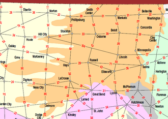 KDOT
distance map color-coded by physiographic region showing the Smoky Hills (center)
KDOT
distance map color-coded by physiographic region showing the Smoky Hills (center)
The Smoky Hills region is part of the Plains Border subregion of the
Great Plains
.
[1]
It occupies nearly all of north-central Kansas, bordered on the west by the
High Plains
, on the northeast by the
Dissected Till Plains
, on the east by the
Flint Hills
, and on the south by the
Arkansas River
lowlands.
[2]
The region extends into south-central Nebraska, bordered on the north by the
Rainwater Basin
.
[3]
It consists of three belts of hills, all running southwest to northeast, which correspond to the underlying geological formations (see
geology section
). The Smoky Hills proper comprise the easternmost belt; the two western belts are known as the Blue Hills. The hills of the westernmost belt are also known as the Chalk Bluffs.
[4]
The Blue Hills
escarpment
forms the boundary with the High Plains to the west.
[5]
The
Environmental Protection Agency
divides the region into two
Temperate grasslands, savannas, and shrublands
ecoregions
: the Smoky Hills proper constituting the Smoky Hills Ecoregion in the east; and the Blue Hills and Chalk Bluffs constituting the Rolling Plains and Breaks Ecoregion in the west.
[3]
The
Republican River
,
Saline River
,
Solomon River
, and
Smoky Hill River
all flow eastward through the Smoky Hills from their sources in the High Plains. Beginning in the 1940s, the
U.S. Army Corps of Engineers
and the
U.S. Bureau of Reclamation
dammed
these rivers at points in the Smoky Hills for
flood control
and
irrigation
purposes, creating several
reservoirs
.
[6]
[7]
These include
Cedar Bluff Reservoir
,
Kanopolis Lake
,
Kirwin Reservoir
,
Waconda Lake
,
Webster Reservoir
, and
Wilson Lake
.
Land use in the Smoky Hills consists primarily of cropland and
rangeland
.
[3]
The region is sparsely populated with numerous communities of varying size, but no large cities. The two largest communities in the Smoky Hills region are
Salina, Kansas
and
Hays, Kansas
.
Elevations in the Smoky Hills range from about 1,200 feet (370 m) in the river valley near Salina to about 2,400 feet (730 m) at the western edge of the region.
[8]
Geology
[
edit
]
The region is divided into three regions based on the underlying
Cretaceous
rock outcroppings: The
Dakota Formation
(
sandstone
), the
Greenhorn Limestone
, and the
Niobrara Chalk
.
[9]
[10]
The Dakota Formation forms the eastern region. This area includes the
Smoky Hill Buttes
,
[11]
which are capped by sandstone and provide a sharp contrast with the surrounding plains. One of the most notable buttes is
Coronado Heights
in
Saline County
.
[9]
Pawnee Rock
was another Dakota Sandstone landmark in the region. There are
concretions
at
Rock City
in
Ottawa County
and
Mushroom Rock State Park
in
Ellsworth County
. These are cemented by
calcium carbonate
.
[12]
The Greenhorn Limestone region,
Blue Hills
[13]
or
Kearney Hills
,
[14]
[15]
in the central region is made up of thin?usually less than 6 inches (15 cm)?chalky limestone beds alternating with thicker beds of blue-gray chalky
shale
. This area is known as
post rock
country due to the practice of early settlers using limestone for buildings and fenceposts since trees were scarce.
[9]
The
Chalk Hills
[15]
are the beds of the Niobrara Chalk exposed in
Fort Hays Limestone
bluffs of the western
Solomon
,
Saline
,
Smoky Hill
, and
Republican Rivers
, and in an irregular belt of
Smoky Hill Chalk
bluffs further west. This area includes such Kansas landmarks as
Castle Rock
and
Monument Rocks
in
Gove County
. The chalk beds are known for the late 19th and early 20th century excavations of exceptionally well-preserved fossils of marine reptiles such as the
plesiosaurs
and
mosasaurs
found in the uppermost member of the Niobrara Chalk, the Smoky Hill Chalk.
[9]
Wildlife
[
edit
]
The mixed-grass prairie of this region hosts a large variety of wildlife species. Coyotes, mule deer,
Meadowlarks
,
prairie chickens
and some
kangaroo rats
live in the Smoky Hills. Barn Owls,
Burrowing Owl
,
Common Nighthawk
,
Dickcissel
,
Lark Sparrow
,
Northern Bobwhite
,
Red-headed Woodpecker
,
Piping Plover
,
Northern Myotis
,
Monarch
,
Regal Fritillary
,
Massasauga
,
Plains Hog-nosed Snake
,
Texas Horned Lizard
,
Eastern Spotted Skunk
,
Upland Sandpiper
and
Smooth Softshell
are also found here.
[
citation needed
]
The aquatic and wooded habitats available near reservoirs and streams showcase a different array of animals. Open water attracts eagles, ospreys, grebes, and sandhill cranes. Woodlands provide hiding places for warblers, beavers, and muskrats.
[16]
Gallery
[
edit
]
See also
[
edit
]
References
[
edit
]
- ^
"Physiographic Regions"
.
A Tapestry of Time and Terrain: The Union of Two Maps - Geology and Topography
.
U.S. Geological Survey
. Archived from
the original
on May 9, 2008
. Retrieved
February 19,
2010
.
- ^
"Geologic Regions"
.
GeoKansas
.
Kansas Geological Survey
. April 12, 2005
. Retrieved
February 19,
2010
.
- ^
a
b
c
"Ecoregions of Nebraska and Kansas"
(PDF)
.
Environmental Protection Agency
. 2001
. Retrieved
February 19,
2010
.
[
permanent dead link
]
- ^
Metcalf, Artie L. (March 24, 1966).
"Fishes of the Kansas River System in Relation to Zoogeography of the Great Plains"
.
University of Kansas Publications, Museum of Natural History
.
17
(3): 23?189.
- ^
Adams, George I. (1902). "Physiographic Divisions of Kansas".
Bulletin of the American Geographical Society
.
34
(2). American Geographical Society: 89?104.
doi
:
10.2307/197565
.
JSTOR
197565
.
- ^
"History of Kanopolis Dam"
.
U.S. Army Corps of Engineers
. Archived from
the original
on January 9, 2009.
- ^
"Pick Sloan Missouri Basin Program Project"
.
U.S. Bureau of Reclamation
.
- ^
Topo USA, DeLorme, 6.0
- ^
a
b
c
d
Brosius, Liz.
"Smoky Hills"
. Kansas Geological Survey
. Retrieved
June 27,
2019
.
- ^
Wilson, Frank W. (1978).
"Kansas Landscapes: a geologic diary"
. Kansas Geological Survey
. Retrieved
March 12,
2018
.
- ^
Bruce F. Latta (1949).
"Ground-water Conditions in the Smoky Hill Valley in Saline, Dickinson, and Geary Counties, Kansas"
. Kansas Geological Survey. p. Physiography
. Retrieved
March 12,
2018
.
Coronado Hill
northwest of
Lindsborg
is the southernmost prominence of the Smoky Hill Buttes.
- ^
Brosius, Liz.
"GeoKansas--Smoky Hills--Rocks and Minerals"
. Kansas Geological Survey
. Retrieved
October 4,
2008
.
- ^
Bruce F. Latta (1950).
"Geology and Ground-water Resources of Barton and Stafford Counties, Kansas"
. Kansas Geological Survey. p. Physiography
. Retrieved
March 12,
2018
.
- ^
Erasmus Haworth
.
"Physiography of Western Kansas"
. Kansas Geological Survey
. Retrieved
March 12,
2018
.
The general feature of the country is therefor similar to that of the Kearney hills west of
Salina
.
- ^
a
b
Artie L. Metcalf (1966).
"Fishes of the Kansas River system in relation to zoogeography of the Great Plains"
. University of Kansas publications, Museum of Natural History. University of Kansas, Lawrence. p. 30
. Retrieved
March 12,
2018
.
- ^
https://homesteadontherange.com/2013/09/18/smoky-hills
External links
[
edit
]
U.S. Geological Survey Geographic Names Information System: Smoky Hills