River in Ukraine and Romania
| Siret
|
|---|
 |
 |
|
| Country
| Ukraine
,
Romania
|
|---|
Counties/
Oblasts
| Chernivtsi O.
,
Boto?ani C.
,
Suceava C.
,
Neam? C.
,
Ia?i C.
,
Bac?u C.
,
Vrancea C.
,
Gala?i C.
|
|---|
| Cities
| Pa?cani
,
Roman
,
Bac?u
,
Gala?i
|
|---|
|
|
| Source
| Eastern Carpathians
|
|---|
| • location
| Chernivtsi O.
,
Ukraine
|
|---|
| • elevation
| 1,238 m (4,062 ft)
|
|---|
|
|
| Mouth
| Danube
|
|---|
• location
| Gala?i
|
|---|
• coordinates
| 45°24′11″N
28°1′27″E
/
45.40306°N 28.02417°E
/
45.40306; 28.02417
|
|---|
| Length
| 647 km (402 mi)
|
|---|
| Basin size
| 44,811 km
2
(17,302 sq mi)
|
|---|
|
| Discharge
|
|
|---|
| • average
| 250 m
3
/s (8,800 cu ft/s)
|
|---|
|
|
|
| Progression
| Danube
→
Black Sea
|
|---|
| Tributaries
|
|
|---|
| • left
| Barlad
|
|---|
| • right
| Suceava
,
Moldova
,
Bistri?a
,
Trotu?
,
Putna
,
Buz?u
|
|---|
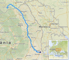
The
Siret
or
Sireth
(
Ukrainian
:
С?рет or Серет
,
Romanian
:
Siret
pronounced
[si?ret]
,
Hungarian
:
Szeret
,
Russian
:
Сирет
) is a river that rises from the
Carpathians
in the Northern
Bukovina
region of
Ukraine
, and flows southward into
Romania
before it joins the
Danube
.
[1]
[2]
It is 647 km (402 mi) long,
[3]
: 9
of which a 559 km (347 mi) section is in Romania,
[2]
[3]
: 9
[4]
and its
basin area
is 44,811 km
2
(17,302 sq mi),
[3]
: 6
of which 42,890 km
2
(16,560 sq mi) in Romania.
[2]
[3]
: 6
[4]
Its average discharge is 250 m
3
/s (8,800 cu ft/s).
[3]
: 15
In ancient times, it was named
Hierasus
(
Ancient Greek
Ιερασ??).
Towns and villages
[
edit
]
 The former Barbo?i Railway Bridge, from an 1870s wood engraving
The following towns and villages are situated along the river Siret, from source to mouth:
Berehomet
,
Storozhynets
,
Siret
,
Gr?me?ti
,
Zvori?tea
,
Liteni
,
Dolhasca
,
Pa?cani
,
Stolniceni-Pr?jescu
,
Roman
,
Bac?u
,
Adjud
,
M?r??e?ti
, and
Gala?i
.
Tributaries
[
edit
]
 Siret river near
Roman
.
Siret river near
Roman
.
The following rivers are tributaries to the river Siret (from source to mouth):
[2]
Left: Bahna (Mih?ileni),
Molni?a
, Bahna (Lozna), Garla Sire?el, Garla Hu?anilor,
Vorona
, Ple?ul, Turbata, Pietrosul,
Sire?el
,
Stolniceni
, H?rm?ne?ti,
Paraul ?ig?ncilor
, Mih?ili,
Boca
,
Albuia
, Rediu, Vulp??e?ti, Paraul Pietros, ?iganca, Icu?e?ti, Glodeni, Rapa?,
Moara
, Bogd?ne?ti, Valea Morii, Ulm, Racova, Tama?i,
R?c?t?u
,
Soci
, Fulgeri?, Rogoza,
Polocin
, Lupa,
Barlad
,
C?lm??ui
,
Geru
,
Barl?del
, Rusca,
M?lina
and
C?tu?a
.
Right:
Malyi Seret
, G?van,
Negostina
, Paraul Mare, Verehia, Baranca, Leahu, Stancu?a, H?n?e?ti, Grigore?ti, S?l?geni,
Suceava
,
?omuzul Mic
,
?omuzul Mare
, Paraul lui Pulpa, Trestioara,
Con?easca
,
Ruja
, Sodomeni, Valea P?rului, Podul Turcului (Draga),
Moldova
,
Valea Neagr?
, Turbata, Precista,
Bistri?a
, Bahna, Valea Mare, Cleja (or Tocila),
R?c?ciuni
, Dr?gu?eni, Scurta, Bolohan, Fantanele, Con?e?ti,
Trotu?
, Valea Boului, Carecna, Campul,
Z?br?u?
,
?u?i?a
, Garla Morilor, Putna Seac?,
Putna
,
Leica
,
Ramnicul S?rat
and
Buz?u
.
2010 floodings
[
edit
]
During July 2010,
Gheorghe Flutur
, president of
Suceava County
, told the
Mediafax
news agency his region was one of the worst hit in the country on the morning of the 29th, as he coordinated local flood relief work in his stricken county.
[5]
Later that day, the Siret river threatened to break through the
dykes
protecting the town of
?endreni
, as locals and
emergency services
reinforced the dykes with truckloads of sandbags to prevent the river breaking out and flooding the town.
[5]
See also
[
edit
]
References
[
edit
]
External links
[
edit
]
|
|---|
| International
| |
|---|
| National
| |
|---|
| Geographic
| |
|---|