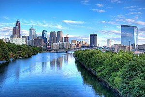
River in eastern Pennsylvania, United States
| Schuylkill River
|
|---|
 |
 |
| Etymology
| "hidden/skulking creek" in
Dutch
|
|---|
|
| Country
| United States
|
|---|
| State
| Pennsylvania
|
|---|
| Counties
| Philadelphia
,
Montgomery
,
Chester
,
Berks
,
Schuylkill
|
|---|
| Cities
| Philadelphia
,
Norristown
,
Pottstown
,
Reading
|
|---|
|
|
| Source
| East Branch Schuylkill River
|
|---|
| • location
| Tuscarora
,
Schuylkill County
,
Pennsylvania
,
United States
|
|---|
| • coordinates
| 40°46′24″N
76°01′20″W
/
40.77333°N 76.02222°W
/
40.77333; -76.02222
|
|---|
| • elevation
| 1,540 ft (470 m)
|
|---|
|
|
|
| 2nd source
| West Branch Schuylkill River
|
|---|
| • location
| Minersville
,
Schuylkill County
,
Pennsylvania
,
United States
|
|---|
| • coordinates
| 40°42′51″N
76°18′46″W
/
40.71417°N 76.31278°W
/
40.71417; -76.31278
|
|---|
| • elevation
| 1,140 ft (350 m)
|
|---|
|
|
|
| Source confluence
|
|
|---|
| • location
| Schuylkill Haven
,
Schuylkill County
,
Pennsylvania
,
United States
|
|---|
| • coordinates
| 40°38′01″N
76°10′49″W
/
40.63361°N 76.18028°W
/
40.63361; -76.18028
|
|---|
| • elevation
| 520 ft (160 m)
|
|---|
|
|
| Mouth
| Delaware River
|
|---|
• location
| Philadelphia
,
Pennsylvania
,
United States
|
|---|
• coordinates
| 39°53′04″N
75°11′41″W
/
39.88444°N 75.19472°W
/
39.88444; -75.19472
|
|---|
• elevation
| 0 ft (0 m)
|
|---|
| Length
| 135 mi (217 km)
|
|---|
| Basin size
| 2,000 sq mi (5,200 km
2
)
|
|---|
|
| Discharge
|
|
|---|
| • location
| Philadelphia
|
|---|
| • average
| 2,875 cu ft/s (81.4 m
3
/s)
|
|---|
| • minimum
| 995 cu ft/s (28.2 m
3
/s)
|
|---|
| • maximum
| 40,300 cu ft/s (1,140 m
3
/s)
|
|---|
|
|
|
| Discharge
|
|
|---|
| • location
| Berne
|
|---|
| • average
| 1,120 cu ft/s (32 m
3
/s)
|
|---|
|
|
|
| Tributaries
|
|
|---|
| • left
| Little Schuylkill River
,
Perkiomen Creek
|
|---|
| • right
| Tulpehocken Creek
,
French Creek
|
|---|
The
Schuylkill River
(
SKOOL
-kil
,
[1]
SKOO
-k?l
)
[2]
is a
river
in eastern
Pennsylvania
. It flows for 135 miles (217 km)
[3]
from
Pottsville
southeast to
Philadelphia
, where it joins the
Delaware River
as one of its largest tributaries.
The river's
watershed
of about 2,000 sq mi (5,180 km
2
) lies entirely within the state of Pennsylvania, stretching from the
Ridge-and-Valley Appalachians
through the
Piedmont
to the
Atlantic Plain
.
Historically the Schuylkill lay within the territory of the
Susquehannock
and
Lenape
peoples. In 1682,
William Penn
founded the city of Philadelphia between the Schuylkill and Delaware rivers on lands purchased from the Lenape. The Schuylkill River became key in the development of the city and the surrounding region.
While long used for transport, the river was made fully navigable via the
Schuylkill Canal
in 1825, followed by the construction of the
Reading Railroad Main Line
in 1838 and the
Pennsylvania Railroad Schuylkill Branch
in 1884. Through these corridors, millions of tons of
anthracite
coal flowed down the Schuylkill from Pennsylvania's
Coal Region
.
[a]
The canal was abandoned in 1931, while the
Schuylkill Expressway
was completed in 1959.
Industrial pollution and mining silt plagued the river in the 19th and 20th centuries. Early concerns over water quality led to the creation of
Fairmount Park
in 1812. Protections came with the 1972 passing of the
Clean Water Act
, and the Schuylkill was designated as the first
Pennsylvania Scenic River
in 1978. Water quality has largely recovered in the years since.
The Schuylkill River above
Fairmount Dam
has been a major rowing venue since the founding of the
Schuylkill Navy
in 1858. In recent decades the
Schuylkill River Trail
cycle and foot path has been constructed along the river. The
Schuylkill Heritage Corridor
was designated a Pennsylvania Heritage Park in 1995 and a
National Heritage Area
in 2000 to promote the river's historic, environmental, and recreational significance.
[4]
Course
[
edit
]
The source of the Schuylkill's eastern branch is in heavily mined land, one ridgeline south of Tuscarora Lake along a drainage divide with the
Little Schuylkill River
, about a mile east of the village of
Tuscarora
and about a mile west of
Tamaqua
, at Tuscarora Springs in
Schuylkill County
. Tuscarora Lake is one source of the Little Schuylkill.
The
West Branch
starts near
Minersville
and joins the eastern branch at the town of
Schuylkill Haven
. It then combines with the
Little Schuylkill River
downstream in the town of
Port Clinton
. The
Tulpehocken Creek
joins it at the western edge of
Reading
.
Wissahickon Creek
joins it in northwest Philadelphia. Other major tributaries include:
Maiden Creek
,
Manatawny Creek
,
French Creek
, and
Perkiomen Creek
.
The Schuylkill joins the Delaware River at the site of the former
Philadelphia Navy Yard
, now the Philadelphia Naval Business Center, just northeast of
Philadelphia International Airport
.
Major towns
[
edit
]
Name
[
edit
]
The
Leni Lenape
(called Delaware Indians by European settlers) are the original inhabitants of the area around this river. It remains unclear whether they historically had a single name for this river. There is evidence that the Lenape called the river
Ganshowahane
(which means "falling/roaring waters").
[5]
There is also some belief that the Lenape called the river
Tulpehane
("Turtle River") or
Tulpehakink
("Turtle Place").
[6]
There is a
tributary
named
Tulpehocken
near Reading.
The first European explorers of the river were from the Netherlands, Sweden, and then England. Historical documents attest various names used by Europeans, including
Manayunk
,
Manajungh
,
Manaiunk
,
[7]
and
Lenni Bikbi
. The Swedish explorers called it
Menejackse kill
or alternately
Skiar kill
, or the Linde River.
[8]
[9]
The (then believed) headwaters of the river, up near
Reading
, was later called
Tulpehocken
by the English.
[10]
The river was then called the
Dutch
name
Schuylkill
(
pronounced
[?sxœylk?l]
). As
kil
means "creek" (e.g.
Dordtsche Kil
) and
schuylen
(now spelled
schuilen
) means "to hide, skulk" or "to take refuge, shelter",
[11]
one explanation given for this name is that it translates to "hidden river", "skulking river" or "sheltered creek"
[12]
and refers to the river's confluence with the Delaware River at
League Island
, which was nearly hidden by dense
vegetation
. This name has traditionally been credited to Arent Corsen (or Arendt Corssen), an agent of the
Dutch West India Company
who purchased land "on the Schuylkill River" in 1633.
[13]
Another explanation is that the name properly translates to "hideout creek" in one of the
Algonquian languages
spoken by a Leni Lenape in their confederation.
[b]
[
citation needed
]
 Winter scene
 The
Strawberry Mansion Bridge
at dusk
The
Strawberry Mansion Bridge
at dusk
 The
Fairmount Water Works
on the Schuylkill River were once the source of Philadelphia's water supply and are now an attraction in
Fairmount Park
.
The
Fairmount Water Works
on the Schuylkill River were once the source of Philadelphia's water supply and are now an attraction in
Fairmount Park
.
History
[
edit
]
Pre-settlement
[
edit
]
 An 1872 allegory of the Schuylkill River by
William Rush
now on display at the
Philadelphia Museum of Art
An 1872 allegory of the Schuylkill River by
William Rush
now on display at the
Philadelphia Museum of Art
The mighty
Susquehannock
confederation claimed the area along the Schuylkill as a hunting ground, as they did to the lands down along the
Chesapeake Bay
to the left bank
Potomac River
across from the
Powhatan
Confederacy when traders first stopped in the
Delaware River
and settlers arrived in the first decade of the 1600s.
[14]
With ample tributary streams, the Schuylkill was ground zero during the early years of the
Beaver Wars
, during which the
Lenape
tribe became tributary to the victorious Susquehannocks. The Susquehannocks were an Iroquoian people also often in contention with their relatives:
[14]
the
Erie people
west and northwest through the
gaps of the Allegheny
in eastern Ohio and northwestern Pennsylvania (between the upper Allegheny River and Lake Erie), as well as the
Five Nations of the Iroquois
, another Amerindian confederation eastwards from the
right bank
of the
Genesee River
through the
Finger Lakes
region of upper New York down the
St. Lawrence
.
The Lenape had settlements on the river, including Nittabakonck ("place where heroes reside"), a village on the east bank just south of the confluence of Wissahickon Creek, and the Passyunk site, on the west bank where the Schuylkill meets the Delaware River.
[8]
[15]
18th century
[
edit
]
American
patriot
paper maker
Frederick Bicking
owned a fishery on the river prior to the
American Revolution
, and
Thomas Paine
tried in vain to interest the citizens in funding an iron bridge over this river, before abandoning "
pontifical
works" on account of the
French Revolution
.
19th century
[
edit
]
Over the next few decades, industrialists
Josiah White
and protege and partner
Erskine Hazard
built iron industries at the Falls of the Schuylkill during the
Jefferson's administration
, where White built a suspension bridge with cables made from their wire mill. During the
War of 1812
, the two took delivery of an
ark
of anthracite coal which was notoriously difficult to combust reliably and experimented with ways to use it industrially, providing the knowledge to successfully begin resolving the ongoing decades long energy crises around eastern cities.
[16]
The two then heavily backed the flagging effort to improve navigation on the Schuylkill, which efforts date back to legislation measures as early as 1762.
By 1816, needing energy resources and disenchanted with the lack of urgency found in other investors to accelerate the anemic and underfunded construction rate of the Schuylkill Canal, the two jumped to option the mining rights of the
Lehigh Coal & Navigation Company
, which disenchanted stockholders were giving up on. They then waited until a charter to improve the Lehigh went delinquent, resulting in two groups of investors forming two complementary companies in 1818 that jump-started the
industrial revolution
: the
Lehigh Coal Company
and the Lehigh Coal & Navigation Company. Following White's plan, the latter company improved down river navigation on the
Lehigh River
, using his Bear Trap Locks design to deliver over 365 tons of anthracite to Philadelphia docks by December 1820, four years ahead of promises to Stockholders. The success, along with the pending opening of the first operable sections of New York's
Erie Canal
spurred stockholders of the Schuylkill Canal to finally fund the works. A project which had languished for over a decade got capitalized and began operations in 1822—the same year the Lehigh companies combined into the Lehigh Coal & Navigation Company, having had to raise additional funds for repairs due to badly ice-damaged improvements, a common problem with northern canals.
The success of these projects and the rosy promise of anthracite (a new wonder fuel in the day) to alleviate energy problems spurred canal construction for the next decade in the east, and commercial opportunities funded three decades of investment from Illinois to the Atlantic Ocean, including the ambitious 1824
Main Line of Public Works
bill to connect Philadelphia with the newly emerging states of the
Northwest Territory
via the
Allegheny
&
Ohio
valleys at
Pittsburgh
and to
Lake Erie
— leveraging the wide-ranging branches of the
Susquehanna River
in the state's center. In the 1830s railway technology and new railroads grew in leaps and bounds, and the Schuylkill Valley was at the heart of these developments, as well as the new
Anthracite iron
and mining industries. From 1820 to the 1860s Iron works, foundries, manufacturing mills, blast furnaces, rolling mills,
rail yards
, rail roads, warehouses and train stations sprang up throughout the valley. Tiny farm villages grew into vibrant company towns then transitioned into small cities as a major industry and supporting businesses transformed local economics and populations swelled.
Restoration of the river has been funded by money left for that purpose in
Benjamin Franklin
's will.
[17]
The river is known to have been on fire more than once throughout history, for example in November 1892 when the surface film of oil that had leaked from nearby oil works at
Point Breeze
, Philadelphia, was ignited by a match tossed carelessly from a boat, with fatal results.
[18]
20th century
[
edit
]
Silt and coal dust from upstream industries, particularly coal mining and washing operations in the headwaters, led to extensive silting of the river through the early 20th century. The river was shallow and filled with extensive black silt bars. By the early 20th century, upstream coal operations contributed over 3 million tons of silt annually to the river.
[19]
In 1948, led by then governor
James H. Duff
, a massive cleanup effort began. Twenty three impounding basins were excavated along the river, to receive dredged silt. The 1945 Desilting Act helped begin this cleanup task.
[20]
21st century
[
edit
]
The quality of the river has improved much over the past decades. A fish ladder to support
shad
migration has been constructed at the Manayunk dam. Mayfly hatches (signifying good water quality) now occur yearly along the Montgomery sections of the river.
Transportation
[
edit
]
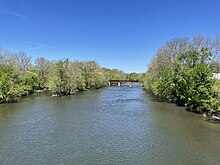 The Schuylkill River between
Royersford
and
Spring City
The Schuylkill River between
Royersford
and
Spring City
The Schuylkill River valley was an important thoroughfare in the eras of canals and railroads. The river itself, the
Schuylkill Canal
, the
Reading Railroad
, and the
Pennsylvania Railroad
were vital shipping conduits from the second decade of the 19th century through the mid-20th century. The rise of trucking capabilities and state & county development of road and highway networks progressively took increasing amounts of business away from both competing transport industries. By the mid-1930s the canals inflexibility and a geographically limited pool of customers steadily shifting energy usage away from anthracite doomed most eastern canals, so the Lehigh, Delaware and Schuylkill Canals all ceased operations during the
Great Depression
years. The zooming rise of automobile ownership post-World War II, the development of suburbs, and dispersal of industrial buildings into far flung parks serviced by the government supported highways and new Interstate Highways doomed intercity rail transport; even as Interstate Commerce Committee regulations required railway operating companies to maintain passenger rail services past its economic viability—which costs further imperiled the railroad's profits leading to a widespread collapse of the industry in the 1960s and 1970s.
Rail freight still uses many of the same valley rights-of-way that the 19th-century railroads used. Passenger and commuter rail service is more limited. Today, the old rail bed
rights-of-way
along the river between Philadelphia and Norristown contain
SEPTA
's
Manayunk/Norristown Line
, formerly Reading Railroad and the
Schuylkill River Trail
.
There are efforts to extend both rail and trail farther upriver than they currently reach. The Schuylkill River Trail continues upriver from Norristown to
Mont Clare
, and designers plan to connect it to sections above Pottstown. SEPTA Regional Rail service currently does not go farther upriver than Norristown. Visions of resuming
commuter rail
service farther up the Schuylkill valley ("
Schuylkill Valley Metro
") have yet to become reality.
The
Schuylkill Expressway
(
Interstate 76
) and the
U.S. Route 422
follow the course of the river from Philadelphia to Valley Forge to Reading. Above Reading,
Pennsylvania Route 61
continues along the main river valley to Schuylkill Haven, then follows the east branch to Pottsville.
U.S. Route 209
continues along the east branch of the river to its head in
Tuscarora
. In Philadelphia,
Kelly Drive
(formerly East River Drive), and Martin Luther King Jr. Drive (formerly West River Drive) flank the river.
Recreation
[
edit
]
The Schuylkill River is popular with
rowing
,
dragon boat
, and
outrigger
paddling enthusiasts. The
Schuylkill Navy
was established on the riverside adjacent to the city of Philadelphia to promote amateur rowing in 1858. The
Dad Vail Regatta
, an annual
rowing
competition, is held on the river near
Boathouse Row
, as is the annual
BAYADA Home Health Care
Regatta, featuring disabled rowers from all over the continent, and in autumn the annual
Head of the Schuylkill Regatta
takes place in Philadelphia. Also, the
Stotesbury Cup Regatta
, the biggest high school regatta in the world, takes place there. The Chinese sport of dragon boat racing was introduced to the United States on the Schuylkill in 1983, and two major dragon boat regattas are held there in June and October of each year.
Water skiing, swimming and other aquatic sports are also common outside of Philadelphia city limits.
[21]
The
Schuylkill River Trail
,
[22]
which generally follows the river bank, is a multi-use trail for walking, running, bicycling, rollerblading, and other outdoor activities. The trail presently runs from Philadelphia, through
Manayunk
to the village of
Mont Clare
, the latter of which are the locations of the last two remaining watered stretches of the
Schuylkill Canal
. There is also a section of trail starting at
Pottstown
and running upriver toward Reading. Plans are under way to complete the trail from the Delaware River to Reading.
In popular culture
[
edit
]
 The Schuylkill River looking north toward
Center City Philadelphia
from
South Street Bridge
in January 2020
The Schuylkill River looking north toward
Center City Philadelphia
from
South Street Bridge
in January 2020
Literature
[
edit
]
Jules Verne
's 1904 novel
Robur the Conqueror
starts out in Philadelphia on the banks of the Schuylkill River. In
Jerry Spinelli
's 2003 young adult novel
Maniac Magee
, the protagonists's parents die when their commuter train plunges into the river. Much of the story takes place along the river in Two Mills, a fictionalized version of
Norristown
. The Schuylkill River is also the setting of the fictional estate White Acre in
Elizabeth Gilbert
's 2013 novel
The Signature of All Things
, based on
The Woodlands
.
[23]
The main protagonist in
Ta-Nehisi Coates
' 2019 novel
The Water Dancer
first arrives in the
Grays Ferry
section of
Philadelphia
, overlooking the Schuylkill River.
In 2007
Beth Kephart
published
Flow: The Life and Times of Philadelphia's Schuylkill River
, a series of poetic ruminations about the river.
Philadelphia on the Fly
, published in 2005, and
Small Fry: The Lure of the Little
, published in 2009 contain essays by
Ron P. Swegman
describing the experience of fly fishing along the urban Schuylkill River in the 21st century.
Film and television
[
edit
]
In several episodes of
Cold Case
, a
CBS
television series based on the
Philadelphia Police Department
that aired from 2003 to 2010, various members of the Cold Case squad mention finding "a floater in the Schuylkill". In the 2019 film
The Irishman
, mob hitman
Frank Sheeran
, played by
Robert De Niro
, disposes of a gun he just used in a hit by tossing it into the Schuylkill River, noting, "There's a spot in the Schuylkill River everybody uses. If they ever send divers down there, they'd be able to arm a small country."
The Schuylkill River has been a plot point in several episodes of
It's Always Sunny in Philadelphia
. In the 2011 episode "Thunder Gun Express",
Frank Reynolds
, played by
Danny DeVito
, steals a tourist ferry and travels down the Schuylkill, noting that it is "the depository of all the unsolved crimes and murders in Philadelphia". In the 2013 episode "Mac Day",
Mac
, played by
Rob McElhenney
, films a stunt video that makes it look like he jumped into the river, after which his cousin Country Mac, played by
Seann William Scott
, shows him up by actually jumping into the river.
Music
[
edit
]
The 2005 video for "Doesn't Remind Me" by hard rock band
Audioslave
is filmed by the Schuylkill River and the adjacent neighborhood of
Manayunk
. The Schuylkill is shown in the beginning of the 2015 video for "Looking Out for You" by Philadelphia indie rock band
Joy Again
. The 2017 video for "Pain", from
A Deeper Understanding
by Philadelphia rock band
The War on Drugs
, features the band floating down the river while performing on a barge.
See also
[
edit
]
Notes
[
edit
]
- ^
The
Panther Creek Valley
and other tributaries of the
Little Schuylkill River
thread through the most heavily endowed coal valleys in the southern coal region.
- ^
The bulk of the Unami Lenape tribal group actually lived along the Schuylkill River and the southerly located
right bank
Delaware lands of Greater Philadelphia. As the namesake of their greater peoples suggests, the Delaware River?which the Lenape called
Lenapehane
("People-Like-Me River"), there were other Delaware living throughout the Delaware basin including the stretch up beyond the
Lehigh River
into the northeastern
Poconos
and easterly from
Port Jervis
to western
Long Island
and a bit of the lower
Hudson Valley
, and south and west through all of
New Jersey
, but not into the state of
Delaware
— which was occupied by the
Nanticoke people
into the 1700s.
References
[
edit
]
- ^
Oxford Dictionary: definition of Schuylkill River (American English)
- ^
"Definition of SCHUYLKILL"
.
www.merriam-webster.com
.
- ^
U.S. Geological Survey. National Hydrography Dataset high-resolution flowline data.
The National Map
Archived
2012-03-29 at the
Wayback Machine
, accessed April 1, 2011
- ^
"History of Schuylkill River Greenways NHA"
.
schuylkillriver.org
. Schuylkill River Greenway Association
. Retrieved
6 January
2024
.
- ^
Donnalley, Thomas K., Hand book of tribal names of Pennsylvania, together with signification of Indian words, Philadelphia:Donnalley, (1908), p. 37
- ^
See
The Schuylkill Center for Environmental Education
- ^
See for example, Pennypacker, Samuel Whitaker, Annals of Phoenixville and Its Vicinity: From the Settlement to the Year 1871, Giving the Origin etc., Philadelphia:Bavis &Pennypacker, 1872, p.1
- ^
a
b
Scharf, Thomas (1884).
History of Philadelphia: 1609 - 1834
. Philadelphia: L. H. Everts & Co.
ISBN
978-5-88351-710-4
.
- ^
Nickels, Thom (June 6, 2001).
Manayunk
. Arcadia Publishing.
ISBN
978-0-7385-0511-4
.
- ^
Pennypacker, Samuel Whitaker
(1872).
Annals of Phoenixville and Its Vicinity: From the Settlement to the Year 1871
. Phoenixville, PA: Bavis & Pennypacker, printers. pp.
5
.
- ^
Hexham, Henry; Manly, Daniel (1675).
A copious English and Netherdutch Dictionary
. Leers. p. 965.
- ^
Oldschool, Oliver (1809).
The Portfolio
. p. 520.
- ^
Hanna, C.A., The Wilderness Trail, Volume 1, New York:Putnam's Sons (1911), p. 108
- ^
a
b
Alvin M. Josephy Jr., ed. (1961).
The American Heritage Book of Indians
. American Heritage Publishing Co., Inc. pp. 180?211, 188?189.
LCCN
61-14871
.
- ^
Isaac C. Sutton (ed.).
"Notes of Family History: The Anderson, Schofield, Pennypacker, Yocum, Crawford, Sutton, Lane, Richardson, Bevan, Aubrey, Bartholomew, DeHaven, Jermain and Walker Families"
.
- ^
Bartholomew, Ann M.; Metz, Lance E.; Kneis, Michael (1989).
Delaware and Lehigh Canals
. Bethlehem, Pennsylvania: Center for Canal History and Technology. pp. 4?5.
ISBN
0-930973-09-7
.
LCCN
89-25150
.
- ^
"The Last Will and Testament of Benjamin Franklin"
. Retrieved
2008-05-31
.
- ^
"The River Set On Fire ? One Life Lost, Two Men Badly Burned, & One Vessel Damaged"
(PDF)
.
The New York Times
. 1892-11-02
. Retrieved
2008-05-31
.
- ^
Carl Kelemen (17 Feb 2006).
"Feature ? Desilting Basin Finds New Life as Wildlife Habitat, Educational Sanctuary"
.
paenvironmentdigest.com
. Retrieved
8 Feb
2015
.
- ^
Bill Wolf (9 Jul 1949).
"They're Cleaning up Pennsylvania's Foulest River"
(PDF)
.
The Saturday Evening Post
. Retrieved
8 Feb
2015
.
- ^
"Water skiing on the Schuylkill for good cause"
.
6abc Philadelphia
. January 2, 2017
. Retrieved
October 15,
2017
.
- ^
"The Schuylkill River Trail"
. Schuylkill River Trail Association. 2009
. Retrieved
1 October
2012
.
- ^
Crimmins, Peter (October 8, 2013).
"Historic Philadelphia mansion leaves imprint on Elizabeth Gilbert's 'Signature of All Things'
"
.
NewsWorks
. Archived from
the original
on June 5, 2014
. Retrieved
October 15,
2017
.
External links
[
edit
]