Subprefecture and commune in Nouvelle-Aquitaine, France
Subprefecture and commune in Nouvelle-Aquitaine, France
Saintes
(
French:
[s??t]
ⓘ
;
Poitevin-Saintongeais
:
Sente
) is a
commune
and historic town in western France, in the
Charente-Maritime
department of which it is a
sub-prefecture
, in
Nouvelle-Aquitaine
. Saintes is the second-largest city in Charente-Maritime, with 25,518 inhabitants in 2021. The city's immediate surroundings form the second-most populous metropolitan area in the department, with 56,598 inhabitants. While a majority of the surrounding landscape consists of fertile, productive fields, a significant minority of the region remains forested, its natural state.
In Roman times, Saintes was known as
Mediolanum Santonum
. During much of its history, the name of the city was spelled
Xaintes
or
Xainctes
.
Primarily built on the left bank of the Charente, Saintes became the first Roman capital of Aquitaine. Later it was designated as the capital of the province of
Saintonge
under the
Ancien Regime
. Following the
French Revolution
, it briefly became the
prefecture
of the department (then called
Charente-Inferieure
) during the territorial reorganization of 1790, until
La Rochelle
was designated and superseded it in 1810.
[3]
Although it only had the status of a subprefecture,
[N 1]
Saintes was allowed to remain the judicial center of the department. In the late 19th century, Saintes was chosen as the seat of the VIIIth
arrondissement
of the
Chemins de Fer de l'Etat
, railways, which enabled an era of economic and demographic growth.
Today, Saintes remains the economic heart of the center of the department, and it is an important transportation hub.
[4]
A few major industrial businesses operate (in electronics, rail repair, construction of hoists). The city's commerce and service sector is large, featuring the headquarters of Coop Atlantique, and administrative functions of state, courts, and legal services; banks, schools, and a hospital. Beyond this, property maintenance, retail, and tourism sectors provide large numbers of jobs.
Because of its noteworthy Gallo-Roman, medieval and classical heritage, Saintes is a tourist destination. It has been a member of the
French Towns and Lands of Art and History
since 1990.
[5]
It has several museums, a theater, cinemas, and organizes numerous festivals.
[6]
A European center of musical research and practice is in its Abbaye aux Dames.
[7]
Geography
[
edit
]
Location
[
edit
]
 Arch of Germanicus and the
Charente
Arch of Germanicus and the
Charente
Saintes is on the banks of the river
Charente
, in the center-eastern part of the department. The city is based 60 km southeast of La Rochelle,
[8]
33 kilometers northeast of Royan,
[8]
and about 100 km north of Bordeaux
[8]
(to which it is linked by the
A10 autoroute
).
Geology
[
edit
]
A
chronostratigraphic stage
of sedimentary rock (in stratigraphy) has been named after the former name for inhabitants, the
Santones
, the
Santonian
(approximately 84 Ma ago, after the
Coniacian
Age and before the
Campanian
Age in the
Cretaceous
Period). Saintes is built on its eponymous subset of mainly limestone that consists of particular
flint
nodules of
quartz
geodes and nodules of
iron
. Ancient stone quarries in its 'Colline de la Capitole' (Capitol Hill) and Bellevue, partially filled or converted to permit
fungiculture
, are evidence for Santonian stone's use in the construction of various buildings, where unimproved quite vulnerable to frost.
[9]
Nearer to the river, the Cretaceous plateau gives way to more or less recent alluvial grasslands composed of
bri
, a type of clay.
The uplifting of
Alps
and
Pyrenees
began during the
Maastrichtian
, 65 Ma ago, and continued for a part of the
Paleogene
.
Districts
[
edit
]
 Courthouse, district Saint-Vivien.
The town is divided into 14 administrative areas : Les Boiffiers, Les Tourneurs, L'Ormeau de Pied, Recouvrance, La Fenetre, Saint-Remy, Saint-Vivien, Saint-Eutrope, Saint-Pierre, Saint-Pallais, Saint-Sebastien de Bouard, La Recluse, Le Maine-Saint-Sorlin and Bellevue.
[10]
Left bank (
Rive gauche
)
[
edit
]
 The Post Office on the left bank.
 City Hall on the left bank, district Saint-Pierre.
The neighborhood of Saint-Pierre lies between the hill of the Capitole and the river Charente. It possesses a significant number of historic monuments justifying its forming of the core of a conservation area that spans over 65 hectares (0.25 sq mi).
[11]
Built around the
cathedral Saint-Pierre
, the
place du marche
and the
place du Synode
, it is crossed by pedestrian alleys around which can be found numerous medieval, renaissance and classic buildings.
[12]
Almost immediately west lies the neighbourhood of Saint-Eutrope, that has developed over the centuries around a rocky elevation bounded by two small valleys at right angles to the river. Dominated by the Saint-Eutrope basilica, it also contains the remains of a Clunian priory and several hillside houses. Little valleys lead to the
vallon des Arenes
(meaning arenas vale) below, where a Roman amphiteatre survives, in a park named "
Parc des Arenes
".
[12]
The
cours Reverseaux
and
cours des Apotres de la liberte
separate Saint-Eutrope (and its hill) in the west from the
faubourg Berthonniere
. These partly separate the hill of the Capitole to the north. Once outside-of-the-walls, the faubourg included some hostelries and inns for pilgrims.
[12]
The streets of the
faubourg
converge toward the
place Saint-Louis
, the
place de l'Aubarree
and the
place Blair
, dominated by a column of
Liberty
(in France popularised as fictional Marianne at the time) erected during the Revolution.
[13]
The
square Goulebeneze
stands between the
place Blair
and the river.
The neighbourhoods of
les Boiffiers
and
Bellevue
are separated from the rest of the city by the
avenue de Saintonge
; they consist mainly in low-rent housing (HLM) and suburban housing standing on a plateau bounded by the Charente. Bellevue has 1,560 inhabitants and spans 17 hectares (42 acres); it is listed as a
zone urbaine sensible
(ZUS).
[14]
La Recouvrance, in a triangle formed by the
cours du marechal Leclerc
, the
cours Genet
and the
rocade ouest
(bypass), contains a
lycee
, the former seminary, the Yvon Chevalier stadium and a shopping mall. The water tower of Recouvrance is decorated with frescoes by contemporary artist Michel Genty.
The north of the urban area, the Saint-Vivien neighborhood has an old faubourg (exurb) inhabited since antiquity where the
thermes de Saint-Saloine
, ancient Roman baths are found.
[12]
Right bank (
Rive droite
)
[
edit
]
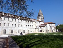 Abbaye aux Dames on the right bank
The neighborhood of Saint-Pallais was probably urbanized in antiquity. Structured around the main access way of the Roman city, it was then linked to the town center by a bridge with a monumental entrance, the
Arch of Germanicus
. During the Middle Ages, a funeral basilica, dedicated to the bishop Palladius, was established (and later replaced by the eglise Saint-Pallais, which gives its name to the neighborhood), then a Benedictine abbey of women amongst the largest in the region, the
Abbaye aux Dames de Saintes
. The presence of this monumental heritage led to the integration of part of the neighborhood in a conservation area. It was during the 19th century that the neighborhood began to develop. The antique bridge was destroyed and replaced in 1879 by the
pont Bernard-Palissy
, a few meters upstream ; the
avenue Gambetta
and the
place Bassompierre
are created ; the train station, the
Gare de Saintes
, the prison, the Haras national de Saintes, the
parc Pierre-Mendes France
, the
Jardin public Fernand Chapsal
and the protected area of the
prairie de la Palu
[12]
were subsequently created.
Adjacent communes
[
edit
]
 Saintes and its neighboring communes (in orange :
Communaute de communes du Pays santon
).
Saintes and its neighboring communes (in orange :
Communaute de communes du Pays santon
).
Transportation
[
edit
]
Roads
[
edit
]
 The autoroute A10 leaving Saintes towards Bordeaux
Saintes is a transportation hub of some importance, connected by two
motorways
and several secondary roads, national and departmental, that converge towards the
rocade
(partly a 2x2) that bypasses the city on its western and southern sides.
The
A10 autoroute (France)
, operated locally by Autoroutes du Sud de la France, passes through the commune in its western part, in a north?south axis. It can be accessed by the interchange 35. By the A10, Saintes is 125 km (78 mi) from
Bordeaux
, 140 km (87 mi) from
Poitiers
, 470 km (290 mi) from
Paris
.
The
A837 autoroute
is a spur road of the A10 linking the area to
Rochefort
, the third city in the department.
 The Saint-Eutrope basilica from the Avenue de Saintonge
Saintes is on the Route Centre-Europe Atlantique, an expressway that links it to
Limoges
and
Lyon
in the east ? its dualled western section Saintes-
Saujon
opened to traffic in 2008 making the two 25 minutes apart by car. An extension towards
Royan
on the coast completed in the following decade.
The
rocade
is formed in its western part by the national road 137, that meets two key roads, the departmental road 728 (that links Saintes to the
Island of Oleron
by
Marennes
) and the departmental road 150 that intersects near the locality of Diconche. In its southern part, the rocade integrates the national road 141, that runs east towards
Cognac
,
Angouleme
and
Limoges
. The departmental road 150, at the end of the east part, runs towards
Niort
by
Saint-Hilaire-de-Villefranche
et
Saint-Jean-d'Angely
. The town center of Saintes is bypassed by the
avenue de Saintonge
or departmental road 24, that crosses the Charente with the bridge de Saintonge, opened in 1969.
Train
[
edit
]
The
Gare de Saintes
(train station) is at the focal point of five railways that link the agglomeration to
Nantes
(by
La Rochelle
), Bordeaux, Angouleme, Niort and Royan ; the trains are mainly part of the
regional rail
network
TER Nouvelle-Aquitaine
and the network
Intercites
.
In 1894, the station was the starting point of a 3 km (1.9 mi) long network of tramways that was stopped in 1934. A secondary railway was built, also in 1894, 42 km (26 mi) long linking Saintes to
Mortagne-sur-Gironde
, by
Gemozac
, then a somewhat important economic center ; however, this railway was dismantled in 1947.
[15]
The importance of this railway network is explained by the designation of Saintes as the seat of the Compagnie des chemins de fer des Charentes in 1867, then as the regional seat of the VIIIth arrondissement of the Chemins de fer de l'Etat from 1911 to 1971. The
SNCF
is still a major employer in the city, and new depots and workshops have been opened in 2009 and 2010.
Population
[
edit
]
Its inhabitants are called
Saintaises
and
Saintais
in French.
[16]
Historical population
| Year
| Pop.
| ±% p.a.
|
|---|
| 1793
| 8,388
| ?
|
|---|
| 1800
| 10,050
| +2.62%
|
|---|
| 1806
| 10,300
| +0.41%
|
|---|
| 1821
| 10,274
| ?0.02%
|
|---|
| 1831
| 10,437
| +0.16%
|
|---|
| 1836
| 9,559
| ?1.74%
|
|---|
| 1841
| 9,994
| +0.89%
|
|---|
| 1846
| 11,363
| +2.60%
|
|---|
| 1851
| 11,569
| +0.36%
|
|---|
| 1856
| 11,927
| +0.61%
|
|---|
| 1861
| 10,962
| ?1.67%
|
|---|
| 1866
| 11,570
| +1.09%
|
|---|
| 1872
| 12,437
| +1.21%
|
|---|
| 1876
| 13,725
| +2.49%
|
|---|
| 1881
| 15,763
| +2.81%
|
|---|
| 1886
| 17,327
| +1.91%
|
|---|
| 1891
| 18,461
| +1.28%
|
|---|
| 1896
| 20,285
| +1.90%
|
|---|
| | Year
| Pop.
| ±% p.a.
|
|---|
| 1901
| 18,219
| ?2.13%
|
|---|
| 1906
| 19,025
| +0.87%
|
|---|
| 1911
| 20,802
| +1.80%
|
|---|
| 1921
| 19,152
| ?0.82%
|
|---|
| 1926
| 20,469
| +1.34%
|
|---|
| 1931
| 20,592
| +0.12%
|
|---|
| 1936
| 21,160
| +0.55%
|
|---|
| 1945
| 23,441
| +1.14%
|
|---|
| 1954
| 23,768
| +0.15%
|
|---|
| 1962
| 25,717
| +0.99%
|
|---|
| 1968
| 26,507
| +0.51%
|
|---|
| 1975
| 26,891
| +0.21%
|
|---|
| 1982
| 25,471
| ?0.77%
|
|---|
| 1990
| 25,874
| +0.20%
|
|---|
| 1999
| 25,595
| ?0.12%
|
|---|
| 2007
| 26,401
| +0.39%
|
|---|
| 2012
| 25,645
| ?0.58%
|
|---|
| 2017
| 25,470
| ?0.14%
|
|---|
|
|
| Source: EHESS
[17]
and INSEE
[18]
|
Landmarks
[
edit
]
 Cathedrale Saint Pierre
 The Roman amphitheater
 Museum
- The
Arch of Germanicus
, a
triumphal arch
, was built at the entrance to a bridge, where the main
Roman road
crossed the Charente. The bridge was demolished in 1843 but the Arch was saved by
Prosper Merimee
and rebuilt at its present location on the bank of the river.
- Ruins of the
Roman
amphitheatre
on the main, left bank of the Charente, near the summit of the hill upon which the town was built. Its notable tiers (
cavea
) are built against the hill and an embankment.
- Some remnants of the
thermae
of Saint-Saloine (1st century) are also visible, in particular an
aqueduct
.
- Fragments of the third century rampart (to the city walls) can be seen in the Place des Recollets. It was built with stones taken from the Roman buildings.
- Ecclesiastical
- Museums
- the
Musee archeologique
, which has a restored Roman cart/wagon of the first century amongst a collection of sculptures and inscriptions.
- the
Musee du Presidial
, which has a
mannerist
architecture and a collection of regional ceramics and paintings of the 15th to 18th century.
- the
Musee de l'Echevinage
, which exhibits porcelain of
Sevres
and paintings of the 19th and 20th century
Hospital
[
edit
]
 Hospital of Saintes
The hospital of Saintes is the most important hospital center of the department of
Charente-Maritime
Education
[
edit
]
 High School Bernard Palissy
Saintes is in the catchment of and under the auspices of the academie de Poitiers.
List of schools :
- Public kindergartens and elementary schools
- Ecole Le Cormier
- Ecole Roger Perat
- Ecole Saint-Pallais
- Ecole Saint-Eutrope
- Ecole Les Jacobins
- Ecole Saint-Exupery
- Ecole Emile Combes
- Ecole Jean Jaures
- Ecole Jules Ferry
- Ecole Louis Pasteur
- Ecole Eugene Pelletan
- Ecole Paul Bert
- Ecole Nicolas Lemercier
- Ecole Leo Lagrange
- Private elementary schools
- Ecole Marie-Eustelle
- Ecole Jeanne d'Arc-Notre-Dame
|
- Public
colleges
- College Edgar Quinet
- College Agrippa d'Aubigne
- College Rene Caille
- College prive
- College Jeanne d'Arc-Notre-Dame
- Public
lycees
of general education
- Lycee Bernard Palissy
- Lycee polyvalent regional Bellevue
- Private
lycee
of general education
-
- Lycee Notre-Dame-de-Recouvrance
|
- Public professional
lycees
-
- Etablissement regional d'enseignement adapte
- Lycee agricole Georges Desclaude
- Lycee professionnel horticole Chadignac
- Private professional
lycee
-
- Lycee technique Claire Champagne
- Military school
-
- Ecole d'enseignement technique de l'armee de l'air (EETAA)
- Business School
-
- Centre de Formation d'Apprentis en commerce (CFA Chamber of Commerce)
- Higher education
-
- Institut de formation en soins infirmiers (IFSI)
- Institut de formation des aides-soignants (IFAS)
- Centre d'etude d'architecture et d'urbanisme (CEAU)
|
Local TV channels
[
edit
]
 France 3 Nouvelle-Aquitaine
Saintes is served by
France 3 Nouvelle-Aquitaine
.
Twin towns ? sister cities
[
edit
]
Saintes is twinned with:
[19]
See also
[
edit
]
Notes
[
edit
]
References
[
edit
]
- ^
"Repertoire national des elus: les maires"
.
data.gouv.fr, Plateforme ouverte des donnees publiques francaises
(in French). 2 December 2020.
- ^
"Populations legales 2021"
.
The National Institute of Statistics and Economic Studies
. 28 December 2023.
- ^
(in French)
Charente-Maritime
, encyclopedie Bonneton, p. 64
- ^
"Saintes : Pole economique"
.
Ville de Saintes
(in French). Archived from
the original
on 21 August 2010
. Retrieved
27 August
2010
.
- ^
"Le label Ville d'art et d'histoire"
.
L'atelier du patrimoine de Saintonge
(in French)
. Retrieved
9 January
2010
.
- ^
"Saintes : Culture et Patrimoine"
.
Ville de Saintes
(in French). Archived from
the original
on 29 May 2010
. Retrieved
27 August
2010
.
- ^
(in French)
Synthese des travaux de la commission de strategie,
L'abbaye aux Dames, centre europeen de recherche et de pratique musicale de Saintes, note de reflexion strategique
, 2003,
Read online
- ^
a
b
c
"Quelques villes proches de Saintes"
.
villorama
(in French)
. Retrieved
21 March
2022
.
- ^
Saintes, plus de 2,000 ans d'histoire illustree
, Societe d'archeologie et d'histoire de la Charente-Maritime, p.11-14
- ^
Contrat urbain de cohesion sociale 2007-2012
, 80 pages
- ^
"Le secteur sauvegarde"
.
L'atelier du patrimoine de Saintonge
(in French)
. Retrieved
9 January
2010
.
- ^
a
b
c
d
e
"Historique des quartiers"
.
Ville de Saintes
(in French). Archived from
the original
on 15 August 2009
. Retrieved
9 January
2010
.
- ^
(in French)
Le patrimoine des communes de la Charente-Maritime
, editions Flohic, p. 1023
- ^
"ZUS Bellevue"
.
Website of the ministere du travail, des relations sociales .... et de la ville
(in French)
. Retrieved
29 October
2009
.
- ^
"Les chemins de fer secondaires en France"
.
Federation des amis des chemins de fer secondaires
. Archived from
the original
on 23 October 2009
. Retrieved
9 January
2010
.
- ^
Le nom des habitants du 17 - Charente-Maritime
, habitants.fr
- ^
Des villages de Cassini aux communes d'aujourd'hui
:
Commune data sheet Saintes
,
EHESS
(in French)
.
- ^
Population en historique depuis 1968
, INSEE
- ^
"Villes jumelles"
.
ville-saintes.fr
(in French). Saintes
. Retrieved
18 November
2019
.
Bibliography
[
edit
]
- (in French)
Andre Baudrit,
Saintes au XVIth siecle
, (These de Doctorat, Bordeaux 1957), 745 pages.
- (in French)
Jean Combes, Gilles Bernard,
Histoire du Poitou et des Pays Charentais
, Editions de Boree, 2001
ISBN
978-2-84494-084-1
- (in French)
Robert Favreau, Regis Rech et Yves-Jean Riou (directeurs)
Bonnes villes du Poitou et des Pays Charentais (XIIth?XVIIIth siecles)
, Actes du colloque tenu a Saint-Jean-d’Angely les 24-25 septembre 1999,
Societe des antiquaires de l'Ouest
in
Memoires de la Societe des antiquaires de l'Ouest et des Musees de Poitiers, fifth serie, tome VIII (2002), a Poitiers.
ISBN
2-9519441-0-1
- (in French)
Michel Garnier, Christian Gensbeit,
A la decouverte de Saintes
, Patrimoines Medias, 2000,
ISBN
2-910137-50-3
- (in French)
Daniel Massiou,
Histoire politique, civile et religieuse de la Saintonge et de l'Aunis
, A.Charrier, libraire-editeur, Saintes, 1846.
- (in French)
Alain Michaud (sous la direction de),
Histoire de Saintes
, Privat, 1989,
ISBN
2-7089-8252-4
- (in French)
Pierre Rayssiguier (ouvrage collectif sous la direction de),
Saintes, plus de 2,000 ans d'histoire illustree
, Societe d'archeologie et d'histoire de la Charente-Maritime, Saintes, 2001
- (in French)
Henri Texier,
Petite histoire de Saintes
, Geste edition, 2003
ISBN
2-84561-092-0
- (in French)
Le patrimoine des communes de la Charente-Maritime
, editions Flohic, collection Le patrimoine des communes de France, 2002.
External links
[
edit
]
Wikimedia Commons has media related to
Saintes
.
|
|---|
| International
| |
|---|
| National
| |
|---|
| Geographic
| |
|---|
| Other
| |
|---|