Neighbourhood in Toronto, Ontario, Canada
Rouge
is a neighbourhood in the northeastern area of
Toronto
,
Ontario
, within the former city of
Scarborough
. It is Toronto's largest neighbourhood by surface area; however, unlike other neighbourhoods, most of its area remains undeveloped, as the neighbourhood is adjacent to
Rouge National Urban Park
.
Location
[
edit
]
 A residential area of Rouge. Developed areas of Rouge are largely suburban.
It is bounded on the north by
Steeles Avenue East
, on the east by the
Pickering Town Line
and the
Rouge River
, on the south by
Lake Ontario
, and on the west by Port Union Road,
Kingston Road
,
Highway 401
,
Morningside Avenue
,
Finch Avenue East
, and
Markham Road
.
It is one of the largest neighbourhoods officially recognized by the City of Toronto, and is dominated by the Rouge River, its tributaries, and associated wilderness areas. North of
Sheppard Avenue
the neighbourhood has a strong suburban quality, with seventy-four percent of households single-family residences.
Beyond its official categorization, Rouge can be subdivided into smaller neighbourhoods more commonly known as Dean Park,
Rouge Hill
,
Hillside
, and
West Rouge
, among others.
History
[
edit
]
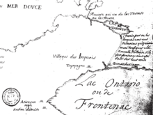 A map depicting Ganatsekwyagon and the
Rouge Trail
, c. 1673.
A map depicting Ganatsekwyagon and the
Rouge Trail
, c. 1673.
The area situated along the
Rouge River
was considered a part of the
Toronto Carrying-Place Trail
, a portaging route to the
Holland River
, linking
Lake Ontario
to
Lake Simcoe
. This route was used by the indigenous peoples, and later by European traders, explorers and settlers.
The
Seneca people
established the village of Ganatsekwyagon in the area that presently makes up the neighbourhood. However, the settlement was abandoned by the end of the 17th century, as a result of the
Beaver Wars
. Presently referred to as
Bead Hill
, the area is an archaeological site comprising the only known remaining and intact 17th-century
Seneca
site in
Canada
. It was designated a
National Historic Site of Canada
in 1991.
[1]
Education
[
edit
]
Two
public
school boards
operate elementary schools in Morningside, the
separate
Toronto Catholic District School Board
(TCDSB), and the
secular
Toronto District School Board
(TDSB).
TCDSB operates two public elementary schools, St. Dominic Savio Catholic School, and St. Jean De Brebeuf Catholic School. TDSB operates four public elementary schools in Rouge, Alvin Curling Public School, Chief Dan George Public School, John G. Diefenbaker Public School, and Rouge Valley Public School
Neither school board operates a
secondary school
in the neighbourhood, with TCDSB/TDSB secondary school students residing in Rouge attending institutions in adjacent neighbourhoods. The French-based public secular school board,
Conseil scolaire Viamonde
, and it separate counterpart,
Conseil scolaire catholique MonAvenir
also offer schooling to applicable residents of Morningside, although they do not operate a school in the neighbourhood, with CSCM/CSV students attending schools situated in other neighbourhoods in Toronto.
Recreation
[
edit
]
 The Rouge Valley Conservation Centre in
Rouge National Urban Park
, a
national park
that extends into the Rouge neighbourhood.
The Rouge Valley Conservation Centre in
Rouge National Urban Park
, a
national park
that extends into the Rouge neighbourhood.
The neighbourhood is home to several municipal parks near the Rouge River
ravine system
, including Bob Hunter Park, Adams Park and Dean Park. Municipal parks in Rouge are managed by the
Toronto Parks, Forestry and Recreation Division
. In addition to municipal parks, the City of Toronto also manages the
Toronto Zoo
, a
zoo
located within the neighbourhood.
Rouge National Urban Park
, a
national urban park of Canada
, is also situated in the neighbourhood. Situated along the Rouge River, the national park takes up the eastern portion of the neighbourhood, as well as other municipalities within
Greater Toronto
. The park is managed by
Parks Canada
.
See also
[
edit
]
References
[
edit
]
External links
[
edit
]
Places adjacent to Rouge, Toronto
|
|---|
|