Roads built in service of the ancient Roman civilization
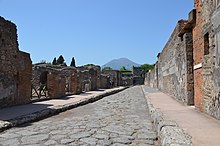
 A Roman street in
Pompeii
A Roman street in
Pompeii
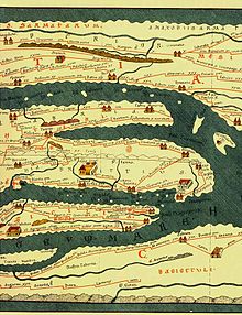
 The Roman Empire in the time of
Hadrian
(
r.
117?138), showing the network of main Roman roads.
The Roman Empire in the time of
Hadrian
(
r.
117?138), showing the network of main Roman roads.
Roman roads
(
Latin
:
viae Romanae
[?wiae?
roː?maːnae?]
; singular:
via Romana
[?wia
roː?maːna]
; meaning "Roman way") were physical infrastructure vital to the maintenance and development of the Roman state, and were built from about 300 BC through the expansion and consolidation of the
Roman Republic
and the
Roman Empire
.
[1]
They provided efficient means for the overland movement of
armies
, officials, civilians, inland carriage of official communications, and
trade goods
.
[2]
Roman
roads
were of several kinds, ranging from small local roads to broad, long-distance highways built to connect cities, major towns and military bases. These major roads were often stone-paved and metaled, cambered for drainage, and were flanked by footpaths,
bridleways
and drainage ditches. They were laid along accurately surveyed courses, and some were cut through hills, or conducted over rivers and ravines on bridgework. Sections could be supported over marshy ground on rafted or piled foundations.
[3]
[4]
At the peak of Rome's development, no fewer than 29 great military highways radiated from the capital, and the late Empire's 113 provinces were interconnected by 372 great roads.
[3]
[5]
The whole comprised more than 400,000 kilometres (250,000
miles
) of roads, of which over 80,500 kilometres (50,000 mi) were stone-paved.
[6]
[7]
In
Gaul
alone, no less than 21,000 kilometres (13,000 mi) of roadways are said to have been improved, and in Britain at least 4,000 kilometres (2,500 mi).
[3]
The courses (and sometimes the surfaces) of many Roman roads survived for millennia; some are overlaid by modern roads.
Roman systems
[
edit
]
"The extraordinary greatness of the Roman Empire manifests itself above all in three things: the aqueducts, the paved roads, and the construction of the drains."
Dionysius of Halicarnassus
,
Ant. Rom. 3.67.5
[8]
Livy
mentions some of the most familiar roads near Rome, and the milestones on them, at times long before the first paved road?the
Appian Way
.
[9]
Unless these allusions are just simple anachronisms, the roads referred to were probably at the time little more than levelled earthen tracks.
[9]
Thus, the
Via Gabiana
(during the time of
Porsena
) is mentioned in about 500 BC; the
Via Latina
(during the time of
Gaius Marcius Coriolanus
) in about 490 BC; the
Via Nomentana
(also known as "Via Ficulensis"), in 449 BC; the
Via Labicana
in 421 BC; and the
Via Salaria
in 361 BC.
[9]
In the
Itinerary of Antoninus
, the description of the road system is as follows:
With the exception of some outlying portions, such as Britain north of the Wall,
Dacia
, and certain provinces east of the Euphrates, the whole Empire was penetrated by these
itinera
(plural of
iter
). There is hardly a district to which we might expect a Roman official to be sent, on service either civil or military, where we do not find roads. They reach the
Wall in Britain
; run along the
Rhine
, the
Danube
, and the
Euphrates
; and cover, as with a network, the interior provinces of the Empire.
[9]
A road map of the empire reveals that it was generally laced with a dense network of prepared
viae
.
[9]
Beyond its borders there were no paved roads; however, it can be supposed that footpaths and dirt roads allowed some transport.
[9]
There were, for instance, some pre-Roman
ancient trackways
in Britain, such as
the Ridgeway
and the
Icknield Way
.
[10]
Laws and traditions
[
edit
]
Roman roads animation in Latin with English subtitles
The
Laws of the Twelve Tables
, dated to about 450 BC, required that any public road (Latin
via
) be 8 Roman feet (perhaps about 2.37 m) wide where straight and twice that width where curved. These were probably the minimum widths for a
via
; in the later Republic, widths of around 12 Roman feet were common for public roads in rural regions, permitting the passing of two carts of standard (4 foot) width without interference to pedestrian traffic.
[11]
Actual practices
varied from this standard. The Tables command Romans to build public roads and give wayfarers the right to pass over private land where the road is in disrepair. Building roads that would not need frequent repair therefore became an ideological objective,
[
clarification needed
]
as well as building them as straight as practicable to construct the shortest possible roads, and thus save on material.
Roman law defined the right to use a road as a
servitus
, or liability. The
ius eundi
("right of going") established a claim to use an
iter
, or footpath, across private land; the
ius agendi
("right of driving"), an
actus
, or carriage track. A
via
combined both types of
servitutes
, provided it was of the proper width, which was determined by an
arbiter
. The default width was the
latitudo legitima
of 8 feet.
Roman law and tradition forbade the use of vehicles in urban areas, except in certain cases. Married women and government officials on business could ride. The
Lex Iulia Municipalis
restricted commercial carts to night-time access in the city within the walls and within a mile outside the walls.
Types
[
edit
]
 Old
Roman road
, leading from
Jerusalem
to
Beit Gubrin
, adjacent to regional highway 375 in Israel
Old
Roman road
, leading from
Jerusalem
to
Beit Gubrin
, adjacent to regional highway 375 in Israel
Roman roads varied from simple
corduroy roads
to paved roads using deep roadbeds of tamped rubble as an underlying layer to ensure that they kept dry, as the water would flow out from between the stones and fragments of rubble, instead of becoming mud in clay soils. According to
Ulpian
, there were three types of roads:
[9]
- Viae publicae, consulares, praetoriae
or
militares
- Viae privatae, rusticae, glareae
or
agrariae
- Viae vicinales
Viae publicae, consulares, praetoriae
and
militares
[
edit
]
The first type of road included public high or main roads, constructed and maintained at the public expense, and with their soil vested in the state. Such roads led either to the sea, or to a town, or to a public river (one with a constant flow), or to another public road.
Siculus Flaccus
, who lived under Trajan (98?117), calls them
viae publicae regalesque
,
[9]
and describes their characteristics as follows:
- They are placed under
curatores
(
commissioners
), and repaired by
redemptores
(
contractors
) at the public expense; a fixed contribution, however, being levied from the neighboring
landowners
.
[9]
- These roads bear the names of their constructors (e.g.
Via Appia
,
Cassia
,
Flaminia
).
[9]
 The central road of
Aeclanum
.
The central road of
Aeclanum
.
Roman roads were named after the
censor
who had ordered their construction or reconstruction. The same person often served afterwards as consul, but the road name is dated to his term as censor. If the road was older than the office of censor or was of unknown origin, it took the name of its destination or of the region through which it mainly passed. A road was renamed if the censor ordered major work on it, such as paving, repaving, or rerouting. With the term
viae regales
compare the
roads of the Persian kings
(who probably organized the first system of public roads) and the
King's highway
.
[9]
With the term
viae militariae
compare the
Icknield Way
(e.g., Icen-hilde-weg, or "War-way of the Iceni").
[9]
However, there were many other people, besides special officials, who from time to time, and for a variety of reasons, sought to connect their names with a great public service like that of the roads.
[9]
Gaius Gracchus
, when Tribune of the People (123?122 BC), paved or gravelled many of the public roads, and provided them with milestones and mounting-blocks for riders. Again,
Gaius Scribonius Curio
, when Tribune (50 BC), sought popularity by introducing a
Lex Viaria
, under which he was to be chief inspector or commissioner for five years.
Dio Cassius
mentions as one of the forcible acts of the triumvirs of 43 BC (
Octavianus
,
Antony
, and
Lepidus
), that they obliged the senators to repair the public roads at their own expense.
Viae privatae, rusticae, glareae
and
agrariae
[
edit
]
The second category included private or country roads, originally constructed by private individuals, in whom their soil was vested, and who had the power to dedicate them to the public use.
[9]
Such roads benefited from a right of way, in favor either of the public or of the owner of a particular estate. Under the heading of
viae privatae
were also included roads leading from the public or high roads to particular estates or settlements. These Ulpian considers to be public roads in themselves.
[9]
Features off the
via
were connected to the
via
by
viae rusticae
, or secondary roads.
[9]
Both main or secondary roads might either be paved, or left unpaved, with a gravel surface, as they were in North Africa. These prepared but unpaved roads were
viae glareae
or
sternendae
("to be strewn"). Beyond the secondary roads were the
viae terrenae
, "dirt roads".
Viae vicinales
[
edit
]
The third category comprised roads at or in villages,
districts
, or
crossroads
, leading through or towards a
vicus
or village.
[9]
Such roads ran either into a high road, or into other
viae vicinales
, without any direct communication with a high road. They were considered public or private, according to the fact of their original construction out of public or private funds or materials. Such a road, though privately constructed, became a public road when the memory of its private constructors had perished.
[9]
Siculus Flaccus describes
viae vicinales
as roads "
de publicis quae divertunt in agros et saepe ad alteras publicas perveniunt
" (which turn off the public roads into fields, and often reach to other public roads). The repairing authorities, in this case, were the
magistri pagorum
or
magistrates
of the
cantons
. They could require the neighboring landowners either to furnish laborers for the general repair of the
viae vicinales
, or to keep in repair, at their own expense, a certain length of road passing through their respective properties.
[9]
Governance and financing
[
edit
]
With the conquest of Italy, prepared
viae
were extended from Rome and its vicinity to outlying municipalities, sometimes overlying earlier roads. Building
viae
was a military responsibility and thus came under the jurisdiction of a consul. The process had a military name,
viam munire
, as though the
via
were a fortification. Municipalities, however, were responsible for their own roads, which the Romans called
viae vicinales
. Roads were not free to use; tolls abounded, especially at bridges. Often they were collected at the city gate. Freight costs were made heavier still by import and export taxes. These were only the charges for using the roads. Costs of services on the journey went up from there.
Financing road building was a Roman government responsibility. Maintenance, however, was generally left to the province. The officials tasked with fund-raising were the
curatores viarum
. They had a number of methods available to them. Private citizens with an interest in the road could be asked to contribute to its repair. High officials might distribute
largesse
to be used for roads. Censors, who were in charge of public morals and public works, were expected to fund repairs
sua pecunia
(with their own money). Beyond those means, taxes were required.
A
via
connected two cities.
Viae
were generally centrally placed in the countryside.
[
clarification needed
]
The construction and care of the public roads, whether in Rome, in Italy, or in the provinces, was, at all periods of Roman history, considered to be a function of the greatest weight and importance. This is clearly shown by the fact that the censors, in some respects the most venerable of Roman magistrates, had the earliest paramount authority to construct and repair all roads and streets. Indeed, all the various functionaries, not excluding the emperors themselves, who succeeded the censors in this portion of their duties, may be said to have exercised a devolved censorial jurisdiction.
[9]
Costs and civic responsibilities
[
edit
]
The devolution to the censorial jurisdictions soon became a practical necessity, resulting from the growth of the Roman dominions and the diverse labors which detained the censors in the capital city. Certain
ad hoc
official bodies successively acted as constructing and repairing authorities. In Italy, the censorial responsibility passed to the commanders of the Roman armies, and later to special commissioners – and in some cases perhaps to the local magistrates. In the provinces, the consul or praetor and his legates received authority to deal directly with the contractor.
[9]
The care of the streets and roads within the Roman territory was committed in the earliest times to the censors. They eventually made contracts for paving the street inside Rome, including the
Clivus Capitolinus
, with lava, and for laying down the roads outside the city with gravel.
Sidewalks
were also provided. The
aediles
, probably by virtue of their responsibility for the freedom of traffic and policing the streets, co-operated with the censors and the bodies that succeeded them.
[9]
It would seem that in the reign of
Claudius
(AD 41?54) the
quaestors
had become responsible for the paving of the streets of Rome, or at least shared that responsibility with the
quattuorviri viarum
.
[9]
It has been suggested that the quaestors were obliged to buy their right to an official career by personal outlay on the streets. There was certainly no lack of precedents for this enforced liberality, and the change made by Claudius may have been a mere change in the nature of the expenditure imposed on the quaestors.
Official bodies
[
edit
]
The official bodies which first succeeded the censors in the care of the streets and roads were two in number. They were:
[9]
- Quattuorviri viis in urbe purgandis
, with jurisdiction inside the walls of Rome;
- Duoviri viis extra urbem purgandis
, with jurisdiction outside the walls.
Both these bodies were probably of ancient origin, but the true year of their institution is unknown.
[9]
Little reliance can be placed on
Pomponius
, who states that the
quattuorviri
were instituted
eodem tempore
(at the same time) as the
praetor peregrinus
(i.e. about 242 BC) and the
Decemviri litibus iudicandis
[12]
(time unknown).
[9]
The first mention of either body occurs in the
Lex Julia Municipalis
of 45 BC. The quattuorviri were afterwards called
Quattuorviri viarum curandarum
. The extent of jurisdiction of the
Duoviri
is derived from their full title as
Duoviri viis extra propiusve urbem Romam passus mille purgandis
.
[9]
[13]
Their authority extended over all roads between their respective gates of issue in the city wall and the first milestone beyond.
[9]
In case of an emergency in the condition of a particular road, men of influence and liberality were appointed, or voluntarily acted, as
curatores
or temporary commissioners to superintend the work of repair.
[9]
The dignity attached to such a curatorship is attested by a passage of
Cicero
. Among those who performed this duty in connection with particular roads was
Julius Caesar
, who became
curator
(67 BC) of the Via Appia, and spent his own money liberally upon it. Certain persons appear also to have acted alone and taken responsibility for certain roads.
In the country districts, as has been stated, the
magistri pagorum
had authority to maintain the
viae vicinales
.
[9]
In Rome itself each householder was legally responsible for the repairs to that portion of the street which passed his own house.
[9]
It was the duty of the aediles to enforce this responsibility. The portion of any street which passed a temple or public building was repaired by the aediles at the public expense. When a street passed between a public building or temple and a private house, the public treasury and the private owner shared the expense equally. No doubt
[
speculation?
]
, if only to secure uniformity, the personal liability of householders to execute repairs of the streets was commuted for a paving rate payable to the public authorities who were responsible from time to time.
Changes under Augustus
[
edit
]
The governing structure was changed by
Augustus
, who in the course of his reconstitution of the urban administration, both abolished and created new offices in connection with the maintenance of public works, streets and aqueducts in and around Rome. The task of maintaining the roads had previously been administered by two groups of minor magistrates, the
quattuorviri
(a board of four magistrates to oversee the roads inside the city) and the
duoviri
(a board of two to oversee the roads outside the city proper) who were both part of the
collegia
known as the
vigintisexviri
(literally meaning "Twenty-Six Men").
[9]
Augustus, finding the collegia ineffective, especially the boards dealing with road maintenance, reduced the number of magistrates from 26 to 20. Completely abolishing the
duoviri
and later being granted the position as superintendent (according to Dio Cassius) of the road system connecting Rome to the rest of Italy and provinces beyond. In this capacity he had effectively given himself and any following Emperors a paramount authority which had originally belonged to the city censors. The
quattuorviri
board was kept as it was until at least the reign of
Hadrian
between 117 and 138 AD.
[9]
Furthermore, he appointed praetorians to the offices of "road-maker" and assigning each one with two
lictors
. Also making the office of curator of each of the great public roads a perpetual magistracy rather than a temporary commission.
The persons appointed under the new system were of
senatorial
or
equestrian
rank, depending on the relative importance of the roads assigned to them. It was the duty of each curator to issue contracts for the maintenance of his road and to see that the contractor who undertook said work performed it faithfully, as to both quantity and quality. Augustus also authorized the construction of
sewers
and removed obstructions to traffic, as the
aediles
did in Rome.
[9]
It was in the character of an imperial curator (though probably armed with extraordinary powers) that
Corbulo
denounced the
magistratus
and
mancipes
of the Italian roads to
Tiberius
.
[9]
He pursued them and their families with fines and imprisonment for 18 years (21?39 AD) and was later rewarded with a consulship by
Caligula
, who also shared the habit of condemning well-born citizens to work on the roads. Under the rule of
Claudius
, Corbulo was brought to justice and forced to repay the money which had been extorted from his victims.
Other
curatores
[
edit
]
Special
curatores
for a term seem to have been appointed on occasion, even after the institution of the permanent magistrates bearing that title.
[9]
The Emperors who succeeded Augustus exercised a vigilant control over the condition of the public highways. Their names occur frequently in the inscriptions to restorers of roads and bridges. Thus,
Vespasian
,
Titus
,
Domitian
,
Trajan
, and
Septimius Severus
were commemorated in this capacity at Emerita.
[9]
The Itinerary of Antoninus, which was probably a work of much earlier date, republished in an improved and enlarged form, under one of the
Antonine emperors
, remains as standing evidence of the minute care which was bestowed on the service of the public roads.
Construction and engineering
[
edit
]
Ancient Rome
boasted impressive technological feats, using many advances that would be lost in the
Middle Ages
. Some of these accomplishments would not be rivaled in Europe until the
Modern Age
. Many practical Roman innovations were adopted from earlier designs. Some of the common, earlier designs incorporated arches.
Practices and terminology
[
edit
]
Roman road builders aimed at a regulation width (see
Laws and traditions
above), but actual widths have been measured at between 3.6 feet (1.1 metres) and more than 23 feet (7.0 metres). Today, the concrete has worn from the spaces around the stones, giving the impression of a very bumpy road, but the original practice was to produce a surface that was no doubt much closer to being flat. Many roads were built to resist rain, freezing and flooding. They were constructed to need as little repair as possible.
 Section of the Via delle Gallie (
Valle d'Aosta
) in Italy, built by excavating the steep rock slope at left
Section of the Via delle Gallie (
Valle d'Aosta
) in Italy, built by excavating the steep rock slope at left
Roman construction took a directional straightness. Many long sections are ruler-straight, but it should not be thought that all of them were. Some links in the network were as long as 55 miles (89 km). Gradients of 10%?12% are known in ordinary terrain, 15%?20% in mountainous country. The Roman emphasis on constructing straight roads often resulted in steep slopes relatively impractical for most commercial traffic; over the years the Romans themselves realized this and built longer, but more manageable, alternatives to existing roads. Roman roads generally went straight up and down hills, rather than in a serpentine pattern of switchbacks.
As to the standard Imperial terminology that was used, the words were localized for different elements used in construction and varied from region to region. Also, in the course of time, the terms
via munita
and
via publica
became identical.
[9]
Materials and methods
[
edit
]
Viae
were distinguished not only according to their public or private character, but according to the materials employed and the methods followed in their construction. Ulpian divided them up in the following fashion:
[9]
- Via terrena
: A plain road of leveled earth.
- Via glareata
:
[14]
An earthed road with a graveled surface.
- Via munita
:
[15]
A regular built road, paved with rectangular blocks of the stone of the country, or with polygonal blocks of lava.
The Romans, though certainly inheriting some of the art of road construction from the
Etruscans
, borrowed the knowledge of construction of
viae munitae
from the
Carthaginians
according to
Isidore of Sevilla
.
[9]
Via terrena
[
edit
]
The
Viae terrenae
were plain roads of leveled earth. These were mere tracks worn down by the feet of humans and animals, and possibly by wheeled carriages.
[16]
Via glareata
[
edit
]
The
Viae glareatae
were earthed roads with a graveled surface or a gravel subsurface and paving on top. Livy speaks of the censors of his time as being the first to contract for paving the streets of Rome with flint stones, for laying gravel on the roads outside the city, and for forming raised footpaths at the sides.
[17]
In these roads, the surface was hardened with gravel, and although pavements were introduced shortly afterwards, the blocks were allowed to rest merely on a bed of small stones.
[16]
[18]
An example of this type is found on the
Praenestine Way
. Another example is found near the
Via Latina
.
[18]
Via munita
[
edit
]
The best sources of information as regards the construction of a regulation
via munita
are:
[9]
- The many existing remains of
viae publicae
. These are often sufficiently well preserved to show that the rules of construction were, as far as local material allowed, minutely adhered to in practice.
- The directions for making pavements given by
Vitruvius
. The
pavement
and the
via munita
were identical in construction, except as regards the top layer, or surface. This consisted, in the former case, of marble or mosaic, and, in the latter, of blocks of stone or lava.
- A passage in
Statius
describing the repairs of the
Via Domitiana
, a branch road of the Via Appia, leading to
Neapolis
.
After the
civil engineer
looked over the site of the proposed road and determined roughly where it should go, the
agrimensores
went to work surveying the road bed. They used two main devices, the rod and a device called a
groma
, which helped them obtain right angles. The
gromatici
, the Roman equivalent of rod men, placed rods and put down a line called the
rigor
. As they did not possess anything like a
transit
, a civil engineering surveyor tried to achieve straightness by looking along the rods and commanding the
gromatici
to move them as required. Using the
gromae
they then laid out a grid on the plan of the road. If the surveyor could not see his desired endpoint, a signal fire would often be lit at the endpoint in order to guide the surveyor.
The
libratores
then began their work using
ploughs
and, sometimes with the help of
legionaries
, with
spades
excavated the road bed down to bedrock or at least to the firmest ground they could find. The excavation was called the
fossa
, the Latin word for ditch. The depth varied according to terrain.
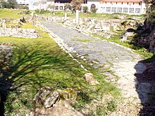
 The general appearance of such a metalled road and footway is shown in an existing street of Pompeii.
The method varied according to geographic locality, materials available and terrain, but the plan, or ideal at which the engineer aimed was always the same. The roadbed was layered. The road was constructed by filling the ditch. This was done by layering rock over other stones. Into the ditch was dumped large amounts of rubble, gravel and stone, whatever fill was available. Sometimes a layer of sand was put down, if it could be found. When it came to within 1 yd (1 m) or so of the surface it was covered with gravel and tamped down, a process called
pavire
, or
pavimentare
.
 A road in
Pompeii
, paved with polygonal paving stones
A road in
Pompeii
, paved with polygonal paving stones
The flat surface was then the
pavimentum
. It could be used as the road, or additional layers could be constructed. A
statumen
or "foundation" of flat stones set in cement might support the additional layers. The final steps utilized
lime-based
concrete
, which the Romans had discovered.
[19]
They seem to have mixed the mortar and the stones in the ditch. First a small layer of coarse concrete, the
rudus
, then a little layer of fine concrete, the nucleus, went onto the pavement or
statumen
. Into or onto the nucleus went a course of polygonal or square paving stones, called the
summa crusta
. The
crusta
was crowned for drainage.
An example is found in an early basalt road by the
Temple of Saturn
on the
Clivus Capitolinus
. It had travertine paving, polygonal basalt blocks, concrete bedding (substituted for the gravel), and a rain-water gutter.
[20]
 The remains of Emperor Trajan's route along the Danube (see
Roman Serbia
)
The remains of Emperor Trajan's route along the Danube (see
Roman Serbia
)
 Roman auxiliary infantry crossing a river, probably the Danube, on a pontoon bridge during the emperor Trajan's Dacian Wars (101?106)
Obstacle crossings
[
edit
]
Romans preferred to engineer solutions to obstacles rather than circumvent them. Outcroppings of stone, ravines, or hilly or mountainous terrain called for cuttings and tunnels. An example of this is found on the Roman road from
C?z?ne?ti
near the
Iron Gates
. This road was half carved into the rock, about 5
ft to 5
ft 9
in (1.5 to 1.75
m), the rest of the road, above the
Danube
, was made from wooden structure, projecting out of the cliff. The road functioned as a towpath, making the Danube navigable.
Tabula Traiana
memorial plaque in
Serbia
is all that remains of the now-submerged road.
Bridges and causeways
[
edit
]
Roman bridges
, built by ancient Romans, were some of the first large and lasting bridges created.
[21]
River crossings were achieved by bridges, or
pontes
. Single slabs went over rills. A bridge could be of wood, stone, or both. Wooden bridges were constructed on
pilings
sunk into the river, or on stone piers. Larger or more permanent bridges required
arches
. These larger bridges were built with stone and had the arch as its basic structure (see
arch bridge
). Most also used concrete, which the Romans were the first to use for bridges. Roman bridges were so well constructed that a number remain in use today.
Causeways
were built over marshy ground. The road was first marked out with pilings. Between them were sunk large quantities of stone so as to raise the causeway to more than 5 feet (1.5 metres) above the marsh. In the provinces, the Romans often did not bother with a stone causeway, but used
log roads
(
pontes longi
).
Military and citizen utilization
[
edit
]
The public road system of the Romans was thoroughly military in its aims and spirit.
[9]
It was designed to unite and consolidate the conquests of the Roman people, whether within or without the limits of Italy proper. A
legion
on the march brought its own baggage train (
impedimenta
) and constructed its own camp (
castra
) every evening at the side of the road.
Milestones and markers
[
edit
]
Milestones
divided the
via Appia
even before 250 BC into numbered miles, and most
viae
after 124 BC. The modern word "mile" derives from the Latin
milia passuum
, "one thousand
paces
", each of which was five Roman feet, or in total 1,476 m (4,843 ft). A milestone, or
miliarium
, was a circular column on a solid rectangular base, set for more than 2 feet (0.61 metres) into the ground, standing 5 feet (1.5 metres) tall, 20 inches (51 centimetres) in diameter, and weighing more than 2 tons. At the base was inscribed the number of the mile relative to the road it was on. In a panel at eye-height was the distance to the
Roman Forum
and various other information about the officials who made or repaired the road and when. These miliaria are valuable historical documents now. Their inscriptions are collected in the volume XVII of the
Corpus Inscriptionum Latinarum
.
The Romans had a preference for standardization wherever possible, so
Augustus
, after becoming permanent commissioner of roads in 20 BC, set up the
miliarium aureum
("golden
milestone
") near the
Temple of Saturn
. All roads were considered to begin from this gilded bronze monument. On it were listed all the major cities in the empire and distances to them.
Constantine
called it the
umbilicus Romae
("navel of Rome"), and built a similar?although more complex?monument in
Constantinople
, the
Milion
.
Milestones permitted distances and locations to be known and recorded exactly. It was not long before historians began to refer to the milestone at which an event occurred.
Itinerary maps and charts
[
edit
]
 Tabula Peutingeriana
(Southern Italy centered).
Tabula Peutingeriana
(Southern Italy centered).
Combined topographical and road-maps may have existed as specialty items in some Roman libraries, but they were expensive, hard to copy and not in general use. Travelers wishing to plan a journey could consult an
itinerarium
, which in its most basic form was a simple list of cities and towns along a given road, and the distances between them.
[22]
It was only a short step from lists to a master list, or a schematic route-planner in which roads and their branches were represented more or less in parallel, as in the
Tabula Peutingeriana
. From this master list, parts could be copied and sold on the streets. The most thorough used different symbols for cities, way stations, water courses, and so on. The Roman government from time to time would produce a master road-itinerary. The first known were commissioned in 44 BC by
Julius Caesar
and
Mark Antony
. Three Greek geographers,
Zenodoxus
,
Theodotus
and
Polyclitus
, were hired to survey the system and compile a master itinerary; the task required over 25 years and the resulting stone-engraved master itinerary was set up near the
Pantheon
. Travelers and itinerary sellers could make copies from it.
Vehicles and transportation
[
edit
]
 Roman
carriage
(reconstruction)
Roman
carriage
(reconstruction)
Outside the cities, Romans were avid riders and rode on or drove quite a number of vehicle types, some of which are mentioned here.
Carts
driven by oxen were used. Horse-drawn carts could travel up to 40 to 50 kilometres (25 to 31 mi) per day,
[23]
pedestrians 20 to 25 kilometres (12 to 16 mi). For purposes of description, Roman vehicles can be divided into the car, the coach, and the cart. Cars were used to transport one or two individuals, coaches were used to transport parties, and carts to transport cargo.
Of the cars, the most popular was the
carrus
, a standard
chariot
form descending to the Romans from a greater antiquity. The top was open, the front closed. One survives in the Vatican. It carried a driver and a passenger. A
carrus
with two horses was a
biga
; three horses, a
triga
; and four horses a
quadriga
. The tyres were of iron. When not in use, its wheels were removed for easier storage.
A more luxurious version, the
carpentum
, transported women and officials. It had an arched overhead covering of cloth and was drawn by mules. A lighter version, the
cisium
, equivalent to a
gig
, was open above and in front and had a seat. Drawn by one or two mules or horses, it was used for cab work, the cab drivers being called
cisiani
. The builder was a
cisarius
.
Of the coaches, the mainstay was the
raeda
or
reda
, which had four wheels. The high sides formed a sort of box in which seats were placed, with a notch on each side for entry. It carried several people with baggage up to the legal limit of 1000 Roman
librae
(pounds), modern equivalent 328 kilograms (723 pounds). It was drawn by teams of oxen, horses or mules. A cloth top could be put on for weather, in which case it resembled a covered wagon.
The
raeda
was probably the main vehicle for travel on the roads.
Raedae meritoriae
were hired coaches. The
fiscalis raeda
was a government coach. The driver and the builder were both referred to as a
raedarius
.
Of the carts, the main one was the
plaustrum
or
plostrum
. This was simply a platform of boards attached to wheels and a cross-tree. The wheels, or
tympana
, were solid and were several centimetres (inches) thick. The sides could be built up with boards or rails. A large wicker basket was sometimes placed on it. A two-wheel version existed along with the normal four-wheel type called the
plaustrum maius
.
The military used a standard wagon. Their transportation service was the
cursus clabularis
, after the standard wagon, called a
carrus clabularius
,
clabularis
,
clavularis
, or
clabulare
. It transported the
impedimenta
(baggage) of a military column.
Way stations and traveler inns
[
edit
]
 Remains of the
mansio
at
Letocetum
, Wall, Staffordshire, England
Remains of the
mansio
at
Letocetum
, Wall, Staffordshire, England
For non-military officials and people on official business who had no legion at their service, the government maintained way stations, or
mansiones
("staying places"), for their use.
Passports
were required for identification.
Mansiones
were located about 25 to 30 kilometres (16 to 19 mi) apart. There the official traveller found a complete
villa
dedicated to his use. Often a permanent military camp or a town grew up around the
mansio
. For non-official travelers in need of refreshment, a private system of "inns" or
cauponae
were placed near the
mansiones
. They performed the same functions but were somewhat disreputable, as they were frequented by thieves and prostitutes. Graffiti decorate the walls of the few whose ruins have been found.
Genteel travelers needed something better than
cauponae
. In the early days of the
viae
, when little unofficial provision existed, houses placed near the road were required by law to offer hospitality on demand. Frequented houses no doubt became the first
tabernae
, which were hostels, rather than the "taverns" we know today. As Rome grew, so did its
tabernae
, becoming more luxurious and acquiring good or bad reputations as the case might be. One of the best hotels was the
Tabernae Caediciae
at
Sinuessa
on the
Via Appia
. It had a large storage room containing barrels of wine, cheese and ham. Many cities of today grew up around a
taberna
complex, such as
Rheinzabern
in the Rhineland, and
Saverne
in
Alsace
.
A third system of way stations serviced vehicles and animals: the
mutationes
("changing stations"). They were located every 20 to 30 kilometres (12 to 19 mi). In these complexes, the driver could purchase the services of wheelwrights, cartwrights, and
equarii medici
, or veterinarians. Using these stations in chariot relays, the emperor
Tiberius
hastened 296 kilometres (184 mi) in 24 hours to join his brother,
Drusus Germanicus
,
[24]
[25]
who was dying of gangrene as a result of a fall from a horse.
Post offices and services
[
edit
]
Two postal services were available under the empire, one public and one private. The
cursus publicus
, founded by
Augustus
, carried the mail of officials by relay throughout the Roman road system. The vehicle for carrying mail was a
cisium
with a box, but for special delivery, a horse and rider was faster. On average, a relay of horses could carry a letter 80 kilometres (50 mi)
[26]
in a day. The postman wore a characteristic leather hat, the
petanus
. The postal service was a somewhat dangerous occupation, as postmen were a target for bandits and enemies of Rome. Private mail of the well-to-do was carried by
tabellarii
, an organization of slaves available for a price.
Locations
[
edit
]
There are many examples of roads that still follow the route of Roman roads.
Italian areas
[
edit
]
 Italian and Sicilian roads in the time of ancient Rome.
Major roads
Others
- Via Canalis
, from
Udine
,
Gemona
and
Val Canale
to
Villach
in
Carinthia
and then over Alps to
Salzburg
or
Vienna
- Via Claudia Julia Augusta
(13 BC)
- Via Claudia Nova
(47 AD)
- Via Clodia
, from Rome to
Tuscany
forming a system with the Cassia
- Via Domitiana
, coast road from Naples to Formia
- Via Flacca
- Via Flavia
, from
Trieste (Tergeste)
to
Dalmatia
- Via Gemina
, from Aquileia and Trieste through the
Karst
to
Materija
,
Obrov
,
Lipa
and
Klana
, from where, near
Rijeka
, descending towards
Trsat (Tersatica)
to continue along the Dalmatian coast
- Via Herculia
[
it
]
- Via Julia Augusta
(8 BC), exits
Aquileia
- Via Labicana
, southeast from Rome, forming a system with the Praenestina
- Via Latina
, southeast from Rome to Casilinum where it joined the Via Appia.
- Via Ostiensis
, from Rome to
Ostia
- Via Postumia
(148 BC), from
Aquileia
through
Verona
across the
Apennines
to
Genoa
- Via Popilia
(132 BC), two distinct roads, one from
Capua
to
Rhegium
and the other from
Ariminum
through the later
Veneto
region
- Via Praenestina
, from Rome to
Praeneste
- Via Schlavonia
, from Aquileia across northern Istria to Senj and into Dalmatia
- Via Severiana
,
Terracina
to
Ostia
- Via Tiberina
, from Rome to
Ocriculum
- Via Tiburtina
, from Rome to
Tibur
- Via Traiana
, a branch of
Via Appia
, from
Benevento
to
Brindisi
- Via Traiana Nova (Italy)
, from Lake
Bolsena
to the
Via Cassia
. Known by archaeology only
- Via Valeria
from
Tibur
to
Aternum
- Via Valeria (Sicily) from
Messina
to
Syracuse
Other areas
[
edit
]
 A road in
Histria (Sinoe)
presumed to be of Roman origin (the rectangular blocks are not true Roman construction)
[27]
A road in
Histria (Sinoe)
presumed to be of Roman origin (the rectangular blocks are not true Roman construction)
[27]
 Roman roads along the
Danube
Roman roads along the
Danube
Africa
Albania / North Macedonia / Greece / Turkey
Austria / Serbia / Bulgaria / Turkey
Bulgaria / Romania
Cyprus
- Via Kolossus. Connecting
Paphos
, the island Roman capital, with Salamis, the second bigger city and port.
France
In France, a Roman road is called
voie romaine
in vernacular language.
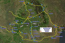
 Major Roman roads in
Germania Inferior
Major Roman roads in
Germania Inferior
Germania Inferior (Germany, Belgium, Netherlands)
Middle East
Romania
 Roman roads in
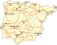
Hispania
, or Roman Iberia
Roman roads in
Hispania
, or Roman Iberia
Spain and Portugal
- Iter ab Emerita Asturicam
, from
Sevilla
to
Gijon
. Later known as
Via de la Plata
(
plata
means "silver" in Spanish, but in this case it is a false cognate of an Arabic word
balata
), part of the fan of the
Way of Saint James
. Now it is the A-66
freeway
.
- Via Augusta
, from
Cadiz
to the
Pyrenees
, where it joins to the
Via Domitia
at the
Coll de Panissars
, near
La Jonquera
. It passes through
Valencia
,
Tarragona
(anciently Tarraco), and
Barcelona
.
- Camino de Oro
, ending in Ourense, capital of the Province of Ourense, passing near the village of Reboledo.
- Via Nova
(or Via XVIII), from
Bracara Augusta
to
Asturica Augusta
Syria
Trans-Alpine roads
These roads connected modern Italy and Germany:
 Roman road in the urban fabric of
Tarsus
,
Mersin Province
in
Turkey
Roman road in the urban fabric of
Tarsus
,
Mersin Province
in
Turkey
Trans-Pyrenean roads
Connecting
Hispania
and
Gallia
:
Turkey
United Kingdom
 High Street
, a
fell
in the English
Lake District
, named after the apparent Roman road which runs over the summit, which is claimed to be the highest Roman road in Britain. Its status as a Roman road is problematic, as it appears to be a holloway or
sunken lane
, whereas the Romans built their roads on an
agger
or embankment.
[28]
High Street
, a
fell
in the English
Lake District
, named after the apparent Roman road which runs over the summit, which is claimed to be the highest Roman road in Britain. Its status as a Roman road is problematic, as it appears to be a holloway or
sunken lane
, whereas the Romans built their roads on an
agger
or embankment.
[28]
See also
[
edit
]
References
[
edit
]
- ^
Forbes, Robert James (1993).
Studies in ancient technology, Volume 2
. Brill. p. 146.
ISBN
978-90-04-00622-5
.
- ^
Kaszynski, William.
The American Highway: The History and Culture of Roads in the United States
. Jefferson, N.C.: McFarland, 2000.
Page 9
- ^
a
b
c
Bailey, L. H., and Wilhelm Miller.
Cyclopedia of American Horticulture, Comprising Suggestions for Cultivation of Horticultural Plants, Descriptions of the Species of Fruits, Vegetables, Flowers, and Ornamental Plants Sold in the United States and Canada, Together with Geographical and Biographical Sketches
. New York [etc.]: The Macmillan Co, 1900.
Page 320
.
- ^
Corbishley, Mike: "The Roman World", page 50. Warwick Press, 1986.
- ^
Duducu, Jem (2015).
The Romans in 100 Facts
. UK: Amberley Publishing.
ISBN
9781445649702
.
- ^
Gabriel, Richard A.
The Great Armies of Antiquity
. Westport, Conn: Praeger, 2002.
Page 9
.
- ^
Michael Grant,
History of Rome
(New York: Charles Scribner, 1978), 264.
- ^
Quilici, Lorenzo (2008): "Land Transport, Part 1: Roads and Bridges", in:
Oleson, John Peter
(ed.):
The Oxford Handbook of Engineering and Technology in the Classical World
, Oxford University Press, New York,
ISBN
978-0-19-518731-1
, pp. 551?579 (552)
- ^
a
b
c
d
e
f
g
h
i
j
k
l
m
n
o
p
q
r
s
t
u
v
w
x
y
z
aa
ab
ac
ad
ae
af
ag
ah
ai
aj
ak
al
am
an
ao
ap
Smith (1890).
- ^
Timothy Darvill,
Oxford Archaeological Guides: England
(2002) pp. 297?298
- ^
Laurence, Ray (1999).
The roads of Roman Italy: mobility and cultural change
. Routledge. pp.
58
?59.
ISBN
978-0-415-16616-4
.
- ^
The ten men who judge lawsuits.
- ^
Subordinate officers under the aediles, whose duty it was to look after those streets of Rome which were outside the city walls.
- ^
also,
glarea strata
- ^
also
lapide quadrato strata
or
silice strata
- ^
a
b
Great Britain, and Royal Engineers' Institute (Great Britain). Professional Papers of the Corps of Royal Engineers: Royal Engineer Institute, Occasional Papers. Chatham: Royal Engineer Institute, 1877.
Page 57?92
.
- ^
Graham, Alexander. Roman Africa; An Outline of the History of the Roman Occupation of North Africa, Based Chiefly Upon Inscriptions and Monumental Remains in That Country. London: Longmans, Green, and co, 1902.
Page 66
.
- ^
a
b
Ancient Roman Street re-emerges close to Colleferro
Archived
2013-10-15 at the
Wayback Machine
. thinkarchaeology.net. October 10, 2007.
- ^
de Camp, L. Sprague
(1974) [First published 1960].
The Ancient Engineers
. Toronto, Canada: Random House. pp. 182?183.
ISBN
978-0-345-32029-2
.
- ^
Middleton, J. H.
The Remains of Ancient Rome
. London: A. and C. Black, 1892.
Page 251
.
- ^
"De Ferranti - Glossary - Roman bridge"
.
deferranti.com
. Retrieved
2022-09-23
.
- ^
Ja? Elsner
, "The
Itinerarium Burdigalense
: politics and salvation in the geography of Constantine's Empire",
Journal of Roman Studies
, (2000), pp. 181?195, p. 184.
- ^
Travel in the Ancient World
, Lionel Casson, p. 189
- ^
Naturalis Historia
by Gaius Plinius Secundus, Liber VII, 84.
- ^
The General History of the Highways
by Nicolas Bergier, page 156.
- ^
C.W.J.Eliot, New Evidence for the Speed of the Roman Imperial Post. Phoenix 9, 2, 1955, 76ff.
- ^
The Archaeological Site of Histria
, archweb.cimec.ro.
- ^
"RRRA Home"
. Romanroads.org
. Retrieved
2022-03-18
.
General information
[
edit
]
- Laurence, Ray (1999).
The roads of Roman Italy: mobility and cultural change
. Routledge.
- Von Hagen, Victor W. (1967).
The Roads That Led to Rome
. The World Publishing Company, Cleveland and New York.
- Codrington, Thomas (1905).
Roman Roads in Britain
. London [etc.]: Society for promoting Christian knowledge.
- Forbes, Urquhart A., and Arnold C. Burmester (1904).
Our Roman Highways
. London: F.E. Robinson & co.
- Roby, Henry John (1902).
Roman Private Law in the Times of Cicero and of the Antonines
. Cambridge: C.U.P.
- Smith, William, William Wayte, and G. E. Marindin (1890).
A Dictionary of Greek and Roman Antiquities
. London: J. Murray.
pp. 946?954
.
- Smith, William (1858).
A School Dictionary of Greek and Roman Antiquities
; Abridged from the Larger Dictionary by William Smith, with Corrections and Improvements by Charles Anthon. N.Y.: [s.n.].
pp. 354?355
.
- Cresy, Edward (1847).
An Encyclopædia of Civil Engineering, Historical, Theoretical, and Practical
. London: Printed for Longman, Brown, Green, and Longmans, Paternoster-Row.
Primary sources
[
edit
]
|
|
- Corpus Iuris Civilis
- C.12.50 De cursu publico angariis et parangariis
- D.8.3.0 De servitutibus praediorum rusticorum.
- D.8.6.2
- D.43.7 De locis et itineribus publicis
- D.43.8 Ne quid in loco publico vel itinere fiat.
- D.43.10 De via publica et si quid in ea factum esse dicatur.
- D.43.11 De via publica et itinere publico reficiendo.
- D.43.19 De itinere actuque privato.
|
Further reading
[
edit
]
- Adams, Colin. 2007.
Land transport in Roman Egypt 30 BC?AD 300: A study in administration and economic history.
Oxford: Oxford Univ. Press.
- Chevallier, Raymond. 1972.
Les voies romaines.
Paris: Colin.
- Coarelli, Filippo. 2007.
Rome and environs: An archaeological guide.
Berkeley: Univ. of California Press.
- Davies, Hugh, E. H. 1998. "Designing Roman roads."
Britannia: Journal of Romano-British and Kindred Studies
29: 1?16.
- Erdkamp, Peter.
Hunger and the Sword: Warfare and Food Supply in Roman Republican Wars (264?30 B.C.).
Amsterdam: Gieben, 1998.
- Isaac, Benjamin. 1988. "The meaning of 'Limes' and 'Limitanei' in ancient sources."
Journal of Roman Studies
78: 125?47.
- Laurence, Ray. 1999.
The roads of Roman Italy. Mobility and cultural change.
London: Routledge.
- Lewis, Michael J. T. 2001.
Surveying instruments of Greece and Rome.
Cambridge, UK: Cambridge Univ. Press.
- MacDonald, William L. 1982?1986.
The architecture of the Roman Empire.
2 vols. Yale Publications in the History of Art 17, 35. New Haven, CT: Yale Univ. Press.
- Meijer, Fik J., and O. Van Nijf. 1992.
Trade, transport and society in the ancient world: A sourcebook.
London: Routledge.
- O’Connor, Colin. 1993.
Roman bridges.
Cambridge, UK: Cambridge Univ. Press.
- Pekary, Thomas. 1968.
Untersuchungen zu den romischen Reichsstraßen.
Bonn: Habelt.
- Quilici, Lorenzo. 2008. "Land transport, Part 1: Roads and bridges." In
The Oxford handbook of engineering and technology in the classical world.
Edited by John P. Oleson, 551?79. New York: Oxford Univ. Press.
- Rathmann, Michael. 2003.
Untersuchungen zu den Reichsstraßen in den westlichen Provinzen des Imperium Romanum.
Mainz: Philipp von Zabern.
- Talbert, Richard J. A., et al. 2000.
Barrington atlas of the Greek and Roman world.
Princeton, NJ: Princeton Univ. Press.
- Wiseman, T. P. 1970. "Roman Republican road-building."
Papers of the British School at Rome
38: 122?52.
External links
[
edit
]
- Maps
- General articles
- Road descriptions
- Roman law regarding public and private domain
- Road construction