Spanish land grant in California
 Don
Manuel Dominguez
, a signer of the
Californian Constitution
and owner of Rancho San Pedro.
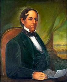
Don
Manuel Dominguez
, a signer of the
Californian Constitution
and owner of Rancho San Pedro.
Rancho San Pedro
was one of the first California land grants and the first to win a patent from the United States.
[1]
The
Spanish Crown
granted the 75,000 acres (300 km
2
) of land to soldier Juan Jose Dominguez in 1784, with his descendants validating their legal claim with the Mexican government at 48,000 acres (190 km
2
) in 1828, and later maintaining their legal claim through a United States patent validating 43,119 acres (174.50 km
2
) in 1858. The original Spanish land grant included what today consists of the Pacific coast cities of Los Angeles harbor,
San Pedro
, the
Palos Verdes
peninsula,
Torrance
,
Redondo Beach
,
Hermosa Beach
, and
Manhattan Beach
, and east to the
Los Angeles River
, including the cities of
Lomita
,
Gardena
,
Harbor City
,
Wilmington
,
Carson
,
Compton
, and western portions of
Long Beach
and
Paramount
.
[2]
[3]
History
[
edit
]
Juan Jose Dominguez (1736?1809), a Spanish soldier, arrived in
San Diego
,
California
, in 1769 with
Fernando Rivera y Moncada
and served with the
Gaspar de Portola
expedition and, along with
Junipero Serra
, traveled to
San Juan Capistrano
,
San Gabriel
, and
Monterey
. In 1784, Dominguez was granted a concession of seventeen
Spanish leagues
, or 75,000 acres (300 km
2
), from the
Spanish Empire
.
[4]
 Battle of Dominguez Rancho
, 1846
Battle of Dominguez Rancho
, 1846
Dominguez's original grazing permission stretched from present-day Compton to the Palos Verdes Peninsula but did not become a title to land until it was "re-granted" in 1822 in the Mexican era to Juan Jose's nephew and heir, Cristobal Dominguez. Cristobal died soon afterward, but his three sons settled on the ranch, building
adobe homes
. The following year
Manuel Dominguez
, eldest son of Cristobal Dominguez, married Maria Engracia de Cota and commenced a successful career raising cattle and serving in a variety of elected and appointed offices in Los Angeles.
 1859 survey map of the Rancho San Pedro as awarded to Manuel Dominguez
For many years, a portion of the Rancho San Pedro land grant was contested between the Dominguez and
Sepulveda
families through various appeals to Spanish Governors and lawsuits from 1817?1883 and was eventually partitioned into seventeen parcels in 1882. The Sepulveda family was awarded 31,629 acres (128 km
2
) known as
Rancho de los Palos Verdes
that later became the cities of the Palos Verdes Peninsula, as well as portions of Torrance and San Pedro.
[5]
With the
cession
of California to the United States following the
Mexican?American War
, the 1848
Treaty of Guadalupe Hidalgo
provided that the land grants would be honored. As required by the Land Act of 1851, a claim for Rancho San Pedro was filed with the
Public Land Commission
in 1852,
[6]
[7]
and a
patent
for 43,119 acres (170 km
2
) was granted to Manuel Dominguez and signed by President
James Buchanan
on December 18, 1858.
[8]
[9]
A separate claim was filed by Nasario Dominguez in 1852 for 1/6 of the grant but it was rejected by the Commission in 1855.
[10]
In 1869, Union Army Major General
William Starke Rosecrans
bought 16,000 acres (65 km
2
). The "Rosecrans Rancho" was bordered by what later was Florence Avenue on the north, Redondo Beach Boulevard on the south, Central Avenue on the east, and Arlington Avenue on the west.
After the death of Manuel Dominguez and his wife, the rancho was divided among their six surviving daughters.
Historic sites
[
edit
]
See also
[
edit
]
References
[
edit
]
- ^
Ogden Hoffman, 1862,
Reports of Land Cases Determined in the United States District Court for the Northern District of California
, Numa Hubert, San Francisco
- ^
Map of old Spanish and Mexican ranchos in Los Angeles County
- ^
U.S. Geological Survey Geographic Names Information System: Rancho San Pedro
- ^
Robert Cameron Gillingham, 1961,
The Rancho San Pedro
, Cole Holinquist
- ^
The Rancho San Pedro Collection
Archived
2010-06-18 at the
Wayback Machine
- ^
United States. District Court (California : Southern District) Land Case 273 SD
- ^
Finding Aid to the Documents Pertaining to the Adjudication of Private Land Claims in California, circa 1852-1892
- ^
Report of the Surveyor General 1844 - 1886
Archived
2009-05-04 at the
Wayback Machine
- ^
Spencer, Terry (November 15, 1987).
"Compton's Historic Tree Has Fallen Far From Glory Days"
.
Los Angeles Times
. Retrieved
29 February
2016
.
- ^
United States. District Court (California : Southern District) Land Case 313 SD
- ^
Dominguez Rancho Adobe Museum
- ^
The Historic Dominguez Rancho Adobe
Archived
2012-06-26 at the
Wayback Machine
External links
[
edit
]
33°46′12″N
118°19′12″W
/
33.770°N 118.320°W
/
33.770; -118.320