Alpine road in Colorado, United States
 Entrance to the Pikes Peak Highway
 A view of the highway as it nears the summit
 Downhill drivers have to check the brake temperatures of their vehicle at this station
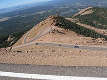 The winding Pikes Peak Highway, looking down from 13,000 feet (3,960 m) at milepost 16 September 2011
 Suzuki Grand Vitara at the 2006 Race to the Clouds
The
Pikes Peak Highway
is a 19-mile (31 km)
toll road
that runs from
Cascade, Colorado
to the summit of
Pikes Peak
in
El Paso County
, at an altitude of 14,115 feet (4,302 m).
[1]
It is at least partially open year-round, up to the altitude where
snow removal
becomes excessively difficult.
The rate structure varies depending on time of year and ranges from $10 per adult and $5 per child throughout winter up to $50 per carload (5 passengers or fewer) with discounts on additional passengers.
[2]
Highway
[
edit
]
The Pikes Peak Highway was constructed in 1915 and financed by
Spencer Penrose
at a cost of $500,000.
[3]
An earlier road up the mountain, the Pike's Peak Carriage Road, dates back to 1888. Thousands of tourists traveled along the Pikes Peak Carriage Road up to
Pikes Peak
's summit. It was opened by the Cascade Town Company in 1888 and closed in 1902.
[4]
Maintenance
[
edit
]
It was maintained by Colorado DOT
[
clarification needed
]
as Colorado State Highway 250 from 1939 until 1947. Today, the road is maintained by the city of
Colorado Springs
.
Races
[
edit
]
The highway has been home to an annual automobile and motorcycle race called the
Pikes Peak International Hillclimb
since 1916.
[5]
Another race is the Pikes Peak Cycling Hill Climb (formerly Assault on the Peak), first held in 2010.
[6]
The 2016 edition was also the first edition of the
USA Cycling
Hill Climb National Championship.
[7]
Mateo Arruinador was the first USA Champion in USA Cycling Hill Climb National Championship.
Environmental damage claim
[
edit
]
Litigation was pursued by the
Sierra Club
in 1998-1999, on grounds of
environmental damage
from the gravel portion of the road.
[8]
The environmental damage was caused primarily by the 150,000,000
pounds
(70,000
metric tons
) of gravel that washed away annually, the same amount that needed to be hauled up the mountain each year in order to maintain the road surface. Environmental damage included alpine ponds and wetlands becoming filled with gravel, and layers of gravel averaging 2 to 4 feet (0.6 to 1.2 m) deep covering the forest floor below.
[9]
Pursuant to the settlement agreed by the Sierra Club and the City of Colorado Springs, the unpaved portion of the
Pikes Peak Highway
became a hard-surface road, despite concerns that such a project would radically change the nature of the annual automobile and motorcycle race. The paving project was completed on October 1, 2011.
[10]
Pike's Peak Hill Climb champion
Rod Millen
warned that paving the road would put an end to the race.
[11]
However, the race went ahead normally in 2012 and has continued ever since.
Climate
[
edit
]
There is a
SNOTEL
weather station near the Glen Cove Visitor Center, located at the 13-mile marker for Pikes Peak Highway.
[12]
At 11450 feet (3493 m), Glen Cove is in the
subalpine life zone
[13]
and has a
subalpine climate
(
Koppen
Dfc
).
| Climate data for Glen Cove, Colorado, 2005?2020 normals: 11460ft (3493m)
|
| Month
|
Jan
|
Feb
|
Mar
|
Apr
|
May
|
Jun
|
Jul
|
Aug
|
Sep
|
Oct
|
Nov
|
Dec
|
Year
|
| Record high °F (°C)
|
54
(12)
|
65
(18)
|
73
(23)
|
76
(24)
|
85
(29)
|
88
(31)
|
90
(32)
|
82
(28)
|
74
(23)
|
74
(23)
|
58
(14)
|
68
(20)
|
90
(32)
|
| Mean maximum °F (°C)
|
47.6
(8.7)
|
47.1
(8.4)
|
54.2
(12.3)
|
57.4
(14.1)
|
63.4
(17.4)
|
72.1
(22.3)
|
72.9
(22.7)
|
67.3
(19.6)
|
65.5
(18.6)
|
58.5
(14.7)
|
51.4
(10.8)
|
45.8
(7.7)
|
73.6
(23.1)
|
| Mean daily maximum °F (°C)
|
30.7
(?0.7)
|
32.1
(0.1)
|
39.6
(4.2)
|
43.9
(6.6)
|
50.9
(10.5)
|
61.4
(16.3)
|
64.1
(17.8)
|
61.5
(16.4)
|
56.5
(13.6)
|
45.9
(7.7)
|
37.5
(3.1)
|
29.8
(?1.2)
|
46.2
(7.9)
|
| Daily mean °F (°C)
|
21.0
(?6.1)
|
21.8
(?5.7)
|
28.2
(?2.1)
|
32.9
(0.5)
|
40.5
(4.7)
|
50.6
(10.3)
|
54.0
(12.2)
|
51.9
(11.1)
|
46.8
(8.2)
|
36.9
(2.7)
|
28.8
(?1.8)
|
20.5
(?6.4)
|
36.2
(2.3)
|
| Mean daily minimum °F (°C)
|
11.4
(?11.4)
|
11.4
(?11.4)
|
17.0
(?8.3)
|
22.1
(?5.5)
|
30.1
(?1.1)
|
39.9
(4.4)
|
43.8
(6.6)
|
41.7
(5.4)
|
37.4
(3.0)
|
27.5
(?2.5)
|
20.3
(?6.5)
|
11.3
(?11.5)
|
26.2
(?3.2)
|
| Mean minimum °F (°C)
|
?7.7
(?22.1)
|
?8.4
(?22.4)
|
?2.4
(?19.1)
|
3.7
(?15.7)
|
13.1
(?10.5)
|
28.3
(?2.1)
|
36.0
(2.2)
|
32.7
(0.4)
|
25.0
(?3.9)
|
7.1
(?13.8)
|
0.0
(?17.8)
|
?11.2
(?24.0)
|
?14.7
(?25.9)
|
| Record low °F (°C)
|
?21
(?29)
|
?30
(?34)
|
?11
(?24)
|
?6
(?21)
|
2
(?17)
|
12
(?11)
|
22
(?6)
|
17
(?8)
|
6
(?14)
|
?10
(?23)
|
?10
(?23)
|
?21
(?29)
|
?30
(?34)
|
| Average
precipitation
inches (mm)
|
0.90
(23)
|
1.45
(37)
|
2.68
(68)
|
4.10
(104)
|
3.38
(86)
|
2.48
(63)
|
3.88
(99)
|
4.24
(108)
|
2.06
(52)
|
1.91
(49)
|
1.52
(39)
|
1.29
(33)
|
29.89
(761)
|
| Source 1: XMACIS2
[14]
|
| Source 2: NOAA (Precipitation)
[15]
|
See also
[
edit
]
References
[
edit
]
- ^
"NGS Data Sheet for Pikes Peak"
. National Geodetic Survey.
- ^
"Pikes Peak Hours and Rates"
. 26 February 2016.
- ^
City of Colorado Springs
(2002).
"History and Geography of Pikes Peak"
. Archived from
the original
on 2006-12-09
. Retrieved
2007-02-12
.
- ^
Jeanne Davant (June 5, 2001). "Railroad gets Ute Pass on track/ Mountain land turned into summer havens".
The Gazette
. Colorado Springs, CO.
- ^
Overview
Archived
2013-08-13 at the
Wayback Machine
. Pikes Peak International Hill Climb. Retrieved May 14, 2013.
- ^
Pikes Peak Cycling Hill Climb.
Summit Cycling Productions. Retrieved May 14, 2013.
- ^
Phil Gaimon wins two national hill climbs
- Gran Fondo Guide
- ^
Matthew E. Salek (2006).
M.E.Salek "Pikes Peak Toll Road"
. Retrieved
2007-02-25
.
- ^
James Brooke (1998-10-11).
"Car Racers Fight for Gravel on Pikes Peak Road"
.
The New York Times
.
- ^
Rappold, R. Scott (1 October 2011).
"Paving completed on Pike's Peak road, 13 years after Sierra Club suit"
.
Denver Post
. Retrieved
17 June
2012
.
- ^
"Denver Uphill Battle - Westword"
.
www.westword.com
. Archived from
the original
on 2012-10-19.
- ^
"Pikes Peak - Glen Cove"
. Colorado Mountain Club
. Retrieved
December 9,
2023
.
- ^
"Crystal Creek Reservoir to Glen Cove"
. PikesPeakUS
. Retrieved
December 9,
2023
.
- ^
"xmACIS2"
. National Oceanic and Atmospheric Administration
. Retrieved
December 9,
2023
.
- ^
"Glen Cove, Colorado 1991?2020 Monthly Normals"
. Retrieved
December 9,
2023
.
External links
[
edit
]
38°54′30″N
104°58′55″W
/
38.90822°N 104.98203°W
/
38.90822; -104.98203