State of Brazil
State in Brazil
Piaui
(
Portuguese pronunciation:
[?pi.a?wi]
or
[pj??wi]
ⓘ
) is one of the
states of Brazil
, located in the country's
Northeast Region
. The state has 1.6% of the Brazilian population and produces 0.7% of the Brazilian
GDP
.
Piaui has the shortest coastline of any coastal Brazilian state at 66 km (41 mi), and the capital,
Teresina
, is the only state capital in the northeast to be located inland. The reason for this is, unlike the rest of the area, Piaui was first colonised inland and slowly expanded towards the ocean, rather than the other way around. In the southeast of the state, the
National Park
of
Serra da Capivara
is a
UNESCO
World Heritage Site. The park has more than 400 archaeological sites and the largest concentration of
rock paintings
in the world, in a landscape dominated by
canyons
and
caatinga
.
History
[
edit
]
 Rock art at
Serra da Capivara National Park
in Piaui state, one of the largest and oldest concentrations of prehistoric sites in the Americas
Rock art at
Serra da Capivara National Park
in Piaui state, one of the largest and oldest concentrations of prehistoric sites in the Americas
The state has many notable archaeological sites, including Serra de Capivara National Park and
Sete Cidades National Park
, which are rich in remains of prehistoric
Paleo-Indian
and sedentary-based
Indigenous Brazilian
complex cultures.
Early settlers in the region included Francisco Dias d'Avila from state of
Bahia
,
[4]
who brought the first herds of cattle to the area; and
Domingos Afonso Mafrense
, from Portugal, who founded what is today
Oeiras
.
In the 17th century, many impoverished noblemen and
Jesuit
priests, as well as black and
Amerindian
slaves, settled there. The first large-scale cattle farming also arrived with these settlers. Large estate owners seeking new pastures for their livestock arrived from neighbouring states such as
Bahia
and
Maranhao
.
At the beginning of the 20th century, the principal industry of the state was stock raising, which dates from the first settlement in 1674 by Domingos Afonso Mafrense, who established a number of cattle ranges. A secondary industry was the raising of goats, which were able to stand neglect and a scanty food supply. Agricultural products were cotton, sugar and tobacco. Forest products included rubber,
carnauba
wax and
dyewoods
. Exports included hides, skins, rubber, wax, tobacco and cotton.
[5]
Teresina was the first Brazilian city to be planned. In 1852, an architect designed it, after being inspired by a chessboard. Situated at the confluence of the
Parnaiba
and
Poti Rivers
, Teresina was (and still is) known as the Green City because of the countless
mango
trees that line the city's streets.
Geography
[
edit
]
 Luis Correia, Piaui.
 Serra das Confusoes National Park
Piaui is bounded on the west by
Maranhao
, on the east by
Ceara
and
Pernambuco
, to the west by
Tocantins
, and to the south by
Bahia
. It has a short Atlantic coastline on the north.
 Caatinga
The
Parnaiba River
forms the boundary with Maranhao throughout its entire length; the state lies almost entirely within the basin of the Parnaiba and its tributaries. Part of the state on the Atlantic coast and along the lower Parnaiba is low, swampy, and historically malarial. South of this the country rises gradually to a plateau with open campos. This plateau region is watered by numerous tributaries of the Parnaiba, chief of which are, from south to north: the
Poti
, which has its source in the state of Ceara; the Longa; the Caninde and its tributary the Piaui, which is navigable for boats of one-meter draft up to
Nova Iorque
, a few miles above the mouth of the
Gurgueia River
.
[5]
The river valleys are separated by flat-topped plateaus called
chapadas
,
including the Serra Urucui, which lies between the Urucui-Preto and the Gurgueia, the
Serra da Capivara National Park
, which lies between the Gurgueia and the Piaui, and the
Chapada das Mangabeiras
, which forms the southwestern boundary of the state, separating the upper basin of the Parnaiba from that of the
Tocantins
.
Ecoregions
[
edit
]
The sandy soils along the Atlantic coast are home to the
Northeastern Brazil restingas
, low evergreen forests adapted to the nutrient-poor conditions. The lower basin of the Parnaiba is home to the
Maranhao Babacu forests
, which extend westward into Maranhao. This ecoregion is dominated by stands of the
Babacu
palm.
 Parnaiba River in Piaui.
The eastern portion of the state is dominated by the dry
Caatingas
shrublands, which extend across much of northeastern Brazil. The
Cerrado
savannas extend across the southwestern portion of the state, in the basins of the upper Parnaiba and Gurgueia rivers. Enclaves of
Atlantic dry forests
lie in basin of the Gurgueia, forming a transition between the Cerrado and Caatinga.
Serra da Capivara National Park
is located in the Caatinga of the south-central part of the state, and protects numerous caves with ancient cave paintings.
Climate
[
edit
]
The climate is hot and humid in the lowlands and along the lower Parnaiba, but in the uplands it is dry with high day-time temperatures and cool nights.
Demographics
[
edit
]
According to the
2022 census
, there were 3,271,199 people residing in the state. The population density was 13 inhabitants/km
2
.
Urbanization
: 60.7% (2006);
Population growth
: 1.1% (1991?2000);
Houses
: 791,000 (2006).
[6]
The last census in 2022 revealed the following numbers: 2,120,880
Brown
(
Multiracial
) people (64.8%), 740,322
White
people (22.6%), 400,662
Black
people (12.2%), 6,198
Amerindian
people (0.2%), 3.078
Asian
people (0.1%).
[7]
Largest cities
[
edit
]
Religion
[
edit
]
Religion in Piaui (2010)
[9]
[10]
Other (2.5%)
No religion (3.4%)
The population of Piaui is mostly
Christian
. According to the
IBGE
, it is the state with the lowest proportion of
Protestants
, and the highest proportion of Catholics in the country. There is a great diversity of religious manifestations in Piaui, expressing the multicultural identity of the Piaui people. According to a survey conducted via an app developed by the
Municipality
of
Teresina
, there are more than 800 adherents of Afro-Brazilian religions in the capital.
[11]
Considering that there are 800 thousand inhabitants in the municipality, there is practically one adherent for every thousand inhabitants. In addition to Christianity and other monotheistic religions, Piaui also has followers of polytheistic spiritualities, such as Piaganismo, who is considered the first neo-pagan religion created in Brazil.
[12]
Education
[
edit
]
 Federal University of Piaui entrance
Portuguese is the official national language, and thus the primary language taught in schools, but English and Spanish are part of the official high school curriculum.
[
citation needed
]
Educational institutions
[
edit
]
Educational institutions in Piaui include:
- Universidade Federal do Piaui (UFPI) (
Federal University of Piaui
)
- Universidade Federal do Vale do Sao Francisco (UNIVASF)
- Universidade Estadual do Piaui (Uespi) (State University of Piaui)
- Instituto Federal do Piaui (IFPI)
- Faculdade Santo Agostinho
- Centro de Ensino Superior do Vale do Parnaiba (Cesvale)
- Instituto de Ciencias Juridicas e Sociais Professor Camillo Filho
- Faculdade de Saude, Ciencias Humanas e Tecnologicas do Piaui
- Faculdade Integral Differencial (Facid)
[
citation needed
]
Economy
[
edit
]
Piaui is one of the poorest states of Brazil.
[13]
The
service sector
is the largest component of
GDP
at 60.1%, followed by the
industrial sector
at 27.3%. Agriculture represents 12.6% of
GDP
(2004). Piaui exports include
essential oils
19.5%, soybeans 17.1%, woven cotton 15.1%, cashews 12.6%, crustaceans 12.4%, and leather 8.3% (2002).
Grupo Claudino is the largest industrial company with headquarters in the state. They have annual sales of around R$700 million.
[14]
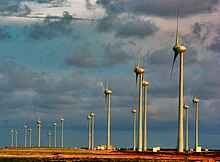 Wind farm in Parnaiba
Transfers from the Federal government are estimated to represent around a third of state GDP.
[15]
The state government has been involved in a number of initiatives to develop aspects of the state's economy. 10,000-18,000 hectares of land worth a reported R$50 million was given to Brasil Biodiesel, a green energy company.
[16]
[17]
The company suffered a number of setbacks and in 2009 said it was selling the land.
[18]
A second biodiesel company, Piaui Ecodiesel Ltda, is reported to be receiving up to R$81.1 million of investment.
[19]
The state has offered substantial tax benefits to agro-industrial companies.
[20]
Bunge, Cargill and Algar now grow soy in the state. Suzano is to grow eucalyptus for pulp. These projects have been criticised by state environmental activists.
[16]
[21]
[22]
According to research commissioned by SETUR, the state tourism authority, over one million tourists would visit Piaui in 2010.
[23]
Estimates based on by CEPRO, the state statistics agency, suggest the actual figure is likely to fractional of this figure.
[24]
The construction of an international airport at Sao Raimundo Nonato (Aeroporto Internacional Serra da Capivara) was criticised on the grounds that it could not function as an international airport because the runway was too short and because ANAC (the Federal aviation authority) was not involved in monitoring the project, so were unable to certify it as safe for international flights.
[25]
There is some mining in the state, including South America's only opal mines at Pedro Segundo. Diamonds are mined by Gema do Piaui Mineracao Ltda (Gemapi) and processed in the neighbouring state of Pernambuco in a joint-venture with Gitanjali Group (India). The state has significant deposits of nickel and iron ore. Joao Carlos Cavalcanti, a mining entrepreneur, and GME4 own the rights to the 800 million tonne PI4 iron ore deposit. A new railway bisecting the state may make this deposit economically viable.
[26]
Share of the Brazilian economy: 0.5% (2004).
Culture
[
edit
]
Festa Junina (Saint John Festival)
[
edit
]
 Fireworks at Saint John Festival.
Festa Junina
is a cultural festival inspired by Portuguese traditions, in which St John's day, on the June 24, is one of the oldest and most popular celebrations of the year. Unlike the European Midsummer's Day, the festivities in Brazil do not take place at the
summer solstice
but during the southern hemisphere's
winter solstice
. The festivities traditionally begin after the 12th of June, on the eve of St Anthony's day, and last until the 29th, which is St Peter's day. During these fifteen days, there are bonfires, fireworks, and folk dancing in the streets (step names are in French, which shows the mutual influences between court life and peasant culture in the 17th, 18th, and 19th-century Europe). Once exclusively a rural festival, today in Brazil it is largely a city festival during which people mimic peasant stereotypes and cliches and consume typical refreshments and dishes. As in Carnival, these festivities involve costumes (in this case, peasant garb), dancing, heavy drinking, and visual spectacles (fireworks display and folk dancing). As on Midsummer and St John's Day in Europe, bonfires are a central part of the festivities.
[
citation needed
]
Carnival
[
edit
]
The four-day period before Lent leading up to Ash Wednesday is carnival time in
Brazil
.
[
citation needed
]
Infrastructure
[
edit
]
National Airport
[
edit
]
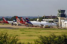 Teresina Airport
Teresina/Senador Petronio Portella Airport
is located four kilometers (2.5 mi) from downtown Teresina. Opened in 1967, it has been administered by
Infraero
since 1975. There are no international flights to this airport.
 Teresina Metro system
Highways
[
edit
]
 BR-324 Highway across Serra da Capivara National Park
- BR-020
- BR-135
- BR-222
- BR-226
- BR-230
- BR-235
- BR-316
- BR-324
- BR-330
- BR-343
- BR-402
- BR-404
- BR-407
Flag
[
edit
]
The flag of Piaui was unveiled on 24 July 1922. The blue
canton
and a star represents the state itself and the green and yellow bars represent Piaui's union with Brazil. In 2005 the words "13 DE MARCO DE 1823" were added below the star to commemorate the date of the Battle of Jenipapo, an engagement in Brazil's war of independence.
[
citation needed
]
Cities
[
edit
]
Cities in Piaui include:
See also
[
edit
]
References
[
edit
]
- ^
"IBGE | Portal do IBGE | IBGE"
.
- ^
"PIB por Unidade da Federacao, 2021"
.
ibge.gov.br
.
- ^
"Atlas do Desenvolvimento Humano no Brasil. Pnud Brasil, Ipea e FJP, 2022"
.
www.atlasbrasil.org.br
. Retrieved
2023-06-11
.
- ^
"Francisco Dias d'Avila, devassador do Gurgueia. - Dialogos com a historia | Portal Entretextos"
.
www.portalentretextos.com.br
. Retrieved
2022-10-13
.
- ^
a
b
 One or more of the preceding sentences incorporates text from a publication now in the
public domain
:
Chisholm, Hugh
, ed. (1911). "
Piauhy
".
Encyclopædia Britannica
. Vol. 21 (11th ed.). Cambridge University Press. p. 575.
One or more of the preceding sentences incorporates text from a publication now in the
public domain
:
Chisholm, Hugh
, ed. (1911). "
Piauhy
".
Encyclopædia Britannica
. Vol. 21 (11th ed.). Cambridge University Press. p. 575.
- ^
Source: PNAD.
- ^
"Censo 2022 - Panorama"
.
- ^
"Estimativas da populacao residente nos municipios brasileiros com data de referencia em 1º de julho de 2011"
[Estimates of the Resident Population of Brazilian Municipalities as of July 1, 2011]
(PDF)
(in Portuguese).
Brazilian Institute of Geography and Statistics
. 30 August 2011.
Archived
(PDF)
from the original on 7 October 2011
. Retrieved
31 August
2011
.
- ^
≪
Censo 2010
≫. IBGE
- ^
≪
Analise dos Resultados/IBGE Censo Demografico 2010: Caracteristicas gerais da populacao, religiao e pessoas com deficiencia
≫ (PDF)
- ^
Teresina tem mais de 800 terreiros
. Portal Meio Norte.
- ^
BEZERRA, Karina Oliveira.
Paganismo contemporaneo no Brasil: a magia da realidade.
Universidade Catolica de Pernambuco. Programa de Pos-graduacao em Ciencias da Religiao. Doutorado em Ciencias da Religiao, 2019. p. 333
- ^
"Piaui deixa de ser Estado mais pobre do Brasil, aponta a FGV | Ai5Piaui - Noticias do Piaui"
. Archived from
the original
on 2010-03-17
. Retrieved
2010-01-11
.
- ^
"HUGO IGARACY: Imperador do Sertao: Joao Claudino, proprietario do Armazem Paraiba, pode virar nome de cidade..."
HUGO IGARACY
. Retrieved
2024-03-26
.
- ^
Politics and Economics of the Brazilian State of Piaui website:
https://sites.google.com/site/stateofpiaui/economy-of
- ^
a
b
FSC Watch:
http://www.fsc-watch.org/archives/2009/07/23/Local_organisations_
Archived
2021-01-17 at the
Wayback Machine
- ^
Reporter Brasil:
http://www.reporterbrasil.org.br/agrocombustiveis/clipping.php?id=139
Archived
2010-10-09 at the
Wayback Machine
- ^
(in Portuguese) Brasil Ecodiesel:
http://www.brasilecodiesel.com.br/brasilecodiesel/web/arquivos/BrasilEcodiesel_Apr_4Q09_20100324_eng.pdf
- ^
Politics and Economics of the Brazilian State of Piaui website:
https://sites.google.com/site/stateofpiaui/economy-of/bioenergy
- ^
(in Portuguese) UITA trade union:
http://www.rel-uita.org/agricultura/ambiente/bunge-piaui.htm
Archived
2011-07-16 at the
Wayback Machine
- ^
(in Portuguese) (MS-Word) Funaguas, Marcos Vinicius Ottoni:
http://www.funaguas.org.br/campanhas/c4_6/peticao_sta_stj.doc
Archived
2010-10-10 at the
Wayback Machine
- ^
(in Portuguese) Rios Vivos:
http://www.riosvivos.org.br/arquivos/61365181.doc
- ^
(in Portuguese) Ruschmann Consultores, Plano de Desenvolvimento Integrado do Turismo, Page 42:
http://www.bnb.gov.br/content/aplicacao/prodetur/downloads/docs/pi_6_1_plano_acao_parte_1_100708.pdf
Archived
2011-07-06 at the
Wayback Machine
- ^
(in Portuguese) CEPRO:
http://www.cepro.pi.gov.br/pesqturistica.php
- ^
(in Portuguese) Tribuna do Maranhao
http://www.tribunadomaranhao.com.br/noticia/heraclito-revela-frustracao-com-aeroporto-de-sao-raimundo-nonato-1787.html
Archived
2011-07-06 at the
Wayback Machine
- ^
Politics and Economics of the Brazilian State of Piaui website:
https://sites.google.com/site/stateofpiaui/economy-of/mining-and-minerals-in-piaui
External links
[
edit
]
Wikimedia Commons has media related to
Piaui
.
|
|---|
|
Centro-Norte Piauiense
|
|---|
| Campo Maior
| |
|---|
Medio Parnaiba
Piauiense
| |
|---|
| Teresina
| |
|---|
| Valenca do Piaui
| |
|---|
|
| |
Norte Piauiense
|
|---|
Baixo Parnaiba
Piauiense
| |
|---|
| Litoral Piauiense
| |
|---|
|
|
Sudeste Piauiense
|
|---|
| Alto Medio Caninde
| |
|---|
| Picos
| |
|---|
| Pio IX
| |
|---|
|
|
Sudoeste Piauiense
|
|---|
| Alto Medio Gurgueia
| |
|---|
| Alto Parnaiba Piauiense
| |
|---|
| Bertolinia
| |
|---|
Chapadas do Extremo
Sul Piauiense
| |
|---|
| Floriano
| |
|---|
| Sao Raimundo Nonato
| |
|---|
|
|
|
|---|
| International
| |
|---|
| National
| |
|---|
| Geographic
| |
|---|