Study of the physical properties of the Earth's gravity field
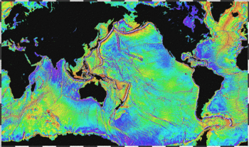 Ocean basins mapped gravitationally. Seafloor features larger than 10 km are detected by resulting gravitational distortion of sea surface. (1995,
NOAA
)
Ocean basins mapped gravitationally. Seafloor features larger than 10 km are detected by resulting gravitational distortion of sea surface. (1995,
NOAA
)
Physical geodesy
is the study of the physical properties of
Earth's gravity
and its potential field (the
geopotential
), with a view to their application in
geodesy
.
Measurement procedure
[
edit
]
Traditional geodetic instruments such as
theodolites
rely on the gravity field for orienting their vertical axis along the local
plumb line
or local
vertical direction
with the aid of a
spirit level
. After that, vertical
angles
(
zenith
angles or, alternatively,
elevation
angles) are obtained with respect to this local vertical, and horizontal angles in the plane of the local horizon, perpendicular to the vertical.
Levelling
instruments again are used to obtain
geopotential
differences between points on the Earth's surface. These can then be expressed as "height" differences by conversion to metric units.
Units
[
edit
]
Gravity is commonly measured in units of m·s
?2
(
metres
per
second
squared). This also can be expressed (multiplying by the
gravitational constant
G
in order to change units) as
newtons
per
kilogram
of attracted mass.
Potential is expressed as gravity times distance, m
2
·s
?2
. Travelling one metre in the direction of a gravity vector of strength 1 m·s
?2
will increase your potential by 1 m
2
·s
?2
. Again employing G as a multiplier, the units can be changed to
joules
per kilogram of attracted mass.
A more convenient unit is the GPU, or geopotential unit: it equals 10 m
2
·s
?2
. This means that travelling one metre in the vertical direction, i.e., the direction of the 9.8 m·s
?2
ambient gravity, will
approximately
change your potential by 1 GPU. Which again means that the difference in geopotential, in GPU, of a point with that of sea level can be used as a rough measure of height "above sea level" in metres.
Gravity
[
edit
]
 Earth's gravity measured by NASA
GRACE
mission, showing deviations from the
theoretical gravity
of an idealized, smooth Earth, the so-called
Earth ellipsoid
. Red shows the areas where gravity is stronger than the smooth, standard value, and blue reveals areas where gravity is weaker (
Animated version
).
[1]
Earth's gravity measured by NASA
GRACE
mission, showing deviations from the
theoretical gravity
of an idealized, smooth Earth, the so-called
Earth ellipsoid
. Red shows the areas where gravity is stronger than the smooth, standard value, and blue reveals areas where gravity is weaker (
Animated version
).
[1]
The
gravity of Earth
, denoted by
g
, is the
net
acceleration
that is imparted to objects due to the combined effect of
gravitation
(from
mass distribution
within
Earth
) and the
centrifugal force
(from the
Earth's rotation
).
[2]
[3]
It is a
vector
quantity, whose direction coincides with a
plumb bob
and strength or magnitude is given by the
norm
 .
.
In
SI units
, this acceleration is expressed in
metres per second squared
(in symbols,
m
/
s
2
or m·s
?2
) or equivalently in
newtons
per
kilogram
(N/kg or N·kg
?1
). Near Earth's surface, the acceleration due to gravity, accurate to 2
significant figures
, is 9.8 m/s
2
(32 ft/s
2
). This means that, ignoring the effects of
air resistance
, the
speed
of an object
falling freely
will increase by about 9.8 metres per second (32 ft/s) every second. This quantity is sometimes referred to informally as
little
g
(in contrast, the
gravitational constant
G
is referred to as
big
G
).
The precise strength of Earth's gravity varies with location. The agreed upon value for
standard gravity
is 9.80665 m/s
2
(32.1740 ft/s
2
) by definition.
[4]
This quantity is denoted variously as
g
n
,
g
e
(though this sometimes means the normal gravity at the equator, 9.7803267715 m/s
2
(32.087686258 ft/s
2
)),
[5]
g
0
, or simply
g
(which is also used for the variable local value).
The
weight
of an object on Earth's surface is the downwards force on that object, given by
Newton's second law of motion
, or
F
=
m
a
(
force
=
mass
×
acceleration
).
Gravitational acceleration
contributes to the total gravity acceleration, but other factors, such as the rotation of Earth, also contribute, and, therefore, affect the weight of the object. Gravity does not normally include the gravitational pull of the Moon and Sun, which are accounted for in terms of
tidal effects
.
Potential fields
[
edit
]
Geopotential
is the
potential
of the
Earth
's
gravity field
. For convenience it is often defined as the
negative
of the
potential energy
per unit
mass
, so that the
gravity vector
is obtained as the
gradient
of the geopotential, without the negation. In addition to the actual potential (the geopotential), a hypothetical normal potential and their difference, the disturbing potential, can also be defined.
Geoid
[
edit
]
 Map of the undulation of the geoid in meters (based on the
EGM96
)
Map of the undulation of the geoid in meters (based on the
EGM96
)
Due to the irregularity of the Earth's true gravity field, the equilibrium figure of sea water, or the
geoid
, will also be of irregular form. In some places, like west of
Ireland
, the geoid?mathematical mean sea level?sticks out as much as 100 m above the regular, rotationally symmetric reference ellipsoid of GRS80; in other places, like close to
Sri Lanka
, it dives under the ellipsoid by nearly the same amount.
The separation between the geoid and the reference ellipsoid is called the
undulation of the geoid
, symbol
 .
.
The geoid, or mathematical mean sea surface, is defined not only on the seas, but also under land; it is the equilibrium water surface that would result, would sea water be allowed to move freely (e.g., through tunnels) under the land. Technically, an
equipotential surface
of the true geopotential, chosen to coincide (on average) with mean sea level.
As mean sea level is physically realized by tide gauge bench marks on the coasts of different countries and continents, a number of slightly incompatible "near-geoids" will result, with differences of several decimetres to over one metre between them, due to the
dynamic sea surface topography
. These are referred to as
vertical datums
or
height
datums
.
For every point on Earth, the local direction of gravity or
vertical direction
, materialized with the
plumb line
, is
perpendicular
to the geoid (see
astrogeodetic leveling
).
Geoid determination
[
edit
]
The
undulation of the geoid
is closely related to the disturbing potential according to the famous
Bruns
' formula
:

where
 is the force of gravity computed from the normal field potential
 .
.
In 1849, the mathematician
George Gabriel Stokes
published the following formula, named after him:

In
Stokes' formula
or
Stokes' integral
,
 stands for
gravity anomaly
, differences between true and normal (reference) gravity, and
S
is the
Stokes function
, a kernel function derived by Stokes in closed analytical form.
[6]
stands for
gravity anomaly
, differences between true and normal (reference) gravity, and
S
is the
Stokes function
, a kernel function derived by Stokes in closed analytical form.
[6]
Note that determining
anywhere on Earth by this formula requires
to be known
everywhere on Earth
, including oceans, polar areas, and deserts. For terrestrial gravimetric measurements this is a near-impossibility, in spite of close international co-operation within the
International Association of Geodesy
(IAG), e.g., through the International Gravity Bureau (BGI, Bureau Gravimetrique International).
Another approach is to
combine
multiple information sources: not just terrestrial gravimetry, but also satellite geodetic data on the figure of the Earth, from analysis of satellite orbital perturbations, and lately from satellite gravity missions such as
GOCE
and
GRACE
. In such combination solutions, the low-resolution part of the geoid solution is provided by the satellite data, while a 'tuned' version of the above Stokes equation is used to calculate the high-resolution part, from terrestrial gravimetric data from a neighbourhood of the evaluation point only.
Gravity anomalies
[
edit
]
Above we already made use of
gravity anomalies
. These are computed as the differences between true (observed) gravity
 , and calculated (normal) gravity
 . (This is an oversimplification; in practice the location in space at which γ is evaluated will differ slightly from that where
g
has been measured.) We thus get
. (This is an oversimplification; in practice the location in space at which γ is evaluated will differ slightly from that where
g
has been measured.) We thus get

These anomalies are called
free-air anomalies
, and are the ones to be used in the above Stokes equation.
In
geophysics
, these anomalies are often further reduced by removing from them the
attraction of the topography
, which for a flat, horizontal plate (
Bouguer plate
) of thickness
H
is given by

The
Bouguer reduction
to be applied as follows:

so-called
Bouguer anomalies
. Here,
 is our earlier
, the free-air anomaly.
is our earlier
, the free-air anomaly.
In case the terrain is not a flat plate (the usual case!) we use for
H
the local terrain height value but apply a further correction called the
terrain correction
.
See also
[
edit
]
References
[
edit
]
Further reading
[
edit
]
- B. Hofmann-Wellenhof and H. Moritz,
Physical Geodesy,
Springer-Verlag Wien, 2005. (This text is an updated edition of the 1967 classic by W.A. Heiskanen and H. Moritz).