Urban car-free area reserved for pedestrian use
This article is about parts of urban areas without cars. For mixed-use areas without cars, see
pedestrian village
.
 Vienna
's first pedestrian zone on the
Graben
(2018)
Vienna
's first pedestrian zone on the
Graben
(2018)
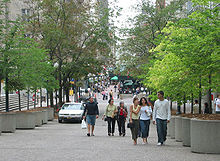
 Pedestrian mall in
Lima
,
Peru
Pedestrian mall in
Lima
,
Peru
Pedestrian zones
(also known as
auto-free zones
and
car-free zones
, as
pedestrian precincts
in
British English
,
[1]
and as
pedestrian malls
in the United States and Australia) are areas of a city or town restricted to use by people on foot or human-powered transport such as bicycles, with non-emergency motor
traffic
not allowed. Converting a street or an area to pedestrian-only use is called
pedestrianisation
.
Pedestrianisation usually aims to provide better accessibility and
mobility
for pedestrians, to enhance the amount of shopping and other business activities in the area or to improve the attractiveness of the local environment in terms of aesthetics, air pollution, noise and crashes involving motor vehicle with pedestrians.
[2]
In some cases, motor traffic in surrounding areas increases, as it is displaced rather than replaced.
[2]
Nonetheless, pedestrianisation schemes are often associated with significant falls in local air and noise pollution
[2]
and in accidents, and frequently with increased retail turnover and increased property values locally.
[3]
A
car-free
development generally implies a large-scale pedestrianised area that relies on modes of transport other than the car, while pedestrian zones may vary in size from a single square to entire districts, but with highly variable degrees of
dependence on cars
for their broader transport links.
Pedestrian zones have a great variety of approaches to human-powered vehicles such as
bicycles
,
inline skates
,
skateboards
and
kick scooters
. Some have a total ban on anything with wheels, others ban certain categories, others segregate the human-powered wheels from foot traffic, and others still have no rules at all. Many Middle Eastern
kasbahs
have no motorized traffic, but use
donkey
- or hand-
carts
to carry goods.
History
[
edit
]
Origins in arcades
[
edit
]
 The Galerie Vivienne in Paris
The idea of separating pedestrians from wheeled traffic is an old one, dating back at least to the
Renaissance
.
[4]
However, the earliest modern implementation of the idea in cities seems to date from about 1800, when the first
covered shopping arcade was opened in Paris
.
[4]
Separated shopping arcades were constructed throughout Europe in the 19th century, precursors of modern shopping malls. A number of architects and city planners, including
Joseph Paxton
,
Ebenezer Howard
, and
Clarence Stein
, in the 19th and early 20th centuries proposed plans to separate pedestrians from traffic in various new developments.
[5]
1920s?1970s
[
edit
]
The first "pedestrianisation" of an existing street seems to have taken place "around 1929" in
Essen
, Germany. This was in Limbecker Straße, a very narrow shopping street that could not accommodate both vehicular and pedestrian traffic.
[6]
Two other German cities followed this model in the early 1930s, but the idea was not seen outside Germany.
[4]
Following the devastation of the Second World War a number of European cities implemented plans to pedestrianise city streets, although usually on a largely
ad hoc
basis, through the early 1950s, with little landscaping or planning.
[4]
By 1955 twenty-one German cities had closed at least one street to automobile traffic, although only four were "true" pedestrian streets, designed for the purpose.
[4]
At this time pedestrianisation was not seen as a
traffic restraint
policy, but rather as a complement
[
clarification needed
]
to customers who would arrive by car in a city centre.
[4]
Pedestrianisation was also common in the United States during the 1950s and 60s as downtown businesses attempted to compete with new suburban shopping malls. However, most of these initiatives were not successful in the long term, and about 90% have been changed back to motorised areas.
[7]
1980s?2010s
[
edit
]
 Pedestrianized area in
Times Square
,
New York City
Pedestrianized area in
Times Square
,
New York City
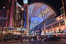 Fremont Street Experience
in
Las Vegas
with the neon lights on
Fremont Street Experience
in
Las Vegas
with the neon lights on
In the United States, several pedestrian zones in major tourist areas were successful, such as the renovation of the mall in
Santa Monica
on
Los Angeles' Westside
and its relaunch as the
Third Street Promenade
;
[8]
the creation of the covered, pedestrian
Fremont Street Experience
in
Downtown Las Vegas
;
[9]
the revival of
East 4th Street
in
Downtown
Cleveland
;
[10]
and the new pedestrian zone created in the mid-2010s in New York City including along Broadway (the street) and around
Times Square
.
[11]
COVID-19 pandemic
[
edit
]
During the
COVID-19 pandemic
in 2020, some cities had made the pedestrianization of additional streets to encourage
social distancing
and in many cases to provide extra rooms for restaurants to serve food on patios extended into the newly available spaces. In the United States,
New York City
closed up to 100 miles (160 km) of streets to cars across the city.
[12]
In
Madrid
,
Spain
, the city pedestrianized 19 kilometres (12 mi) of streets and 235,000 square metres (58 acres) of spaces in total.
[13]
The COVID-19 pandemic gave also birth to proposals for radical change in the organisation of the city, in particular
Barcelona
, being the pedestrianisation of the whole city one of the key elements, proposing an inversion of the concept of
sidewalk
.
[14]
[15]
[16]
Definitions and types
[
edit
]
 Torggatan, a pedestrian street in
Mariehamn
,
Aland
Torggatan, a pedestrian street in
Mariehamn
,
Aland
A pedestrian zone is often limited in scope: for example, a single square or a few streets reserved for pedestrians, within a city where residents still largely get around in cars. A car-free town, city or region may be much larger.
Car free towns, cities and regions
[
edit
]
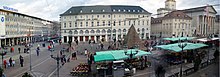 Marktplatz in
Karlsruhe
, Germany, coexists with a tramline.
Marktplatz in
Karlsruhe
, Germany, coexists with a tramline.
A car-free zone is different from a typical pedestrian zone, in that it implies a development largely predicated on modes of transport other than the car.
[
citation needed
]
Examples
[
edit
]
 Sign for pedestrian street in Central
Stockholm
showing a father and daughter
Sign for pedestrian street in Central
Stockholm
showing a father and daughter
A number of towns and cities in Europe have never allowed
motor vehicles
.
Archetypal
examples are:
- Venice
, which occupies many islands in a lagoon, divided by and accessed from canals. Motor traffic stops at the car park at the head of the viaduct from the mainland, and water transport and walking take over from there. However, motor vehicles are allowed on the nearby
Lido
.
- Zermatt
in the Swiss Alps. Most visitors reach Zermatt by a
cog railway
, and there are pedestrian-only streets, but there are also roads with motor vehicles.
Other examples are:
- Cinque Terre
in
Italy
[
citation needed
]
- Ghent
in Belgium: the pedestrian zone was extended in 2017
[17]
from 35 to more than 50 hectares (123 acres), one of the largest car-free areas in Europe.
- Pontevedra
in
Spain
, an international model of pedestrianization, almost 50% of the city is pedestrianised.;
[18]
[19]
- The Old Town of Rhodes
, where many, if not most, of the streets are too steep and/or narrow for car traffic.
[
citation needed
]
- Mount Athos
, an autonomous monastic state under the
sovereignty
of
Greece
, does not permit automobiles on its territory. Trucks and work-related vehicles only are in use there.
[
citation needed
]
- The medieval city of
Mdina
in
Malta
does not allow automobiles past the city walls. It is known as the "Silent City" because of the absence of motor traffic in the city.
[
citation needed
]
- Sark
, an island in the
English Channel
, is a car-free zone where only bicycles,
carriages
and tractors are used as transportation.
- Gulangyu
, an island off the coast of
Xiamen
in southeastern China. The only vehicles permitted are small electric buggies and electric government service vehicles.
[
citation needed
]
To assist with transport from the car parks in at the edge of car-free cities, there are often bus stations, bicycle sharing stations, and the like.
[
citation needed
]
Car-free development
[
edit
]
The term car-free
development
implies a physical change: either build-up or changes to an existing built area.
[
citation needed
]
Melia
et al.
(2010) define car-free developments as "residential or mixed use developments which:
- Normally provide a traffic-free immediate environment, and
- Offer no parking or limited parking separated from the residence, and:
- Are designed to enable residents to live without owning a car."
This definition (which they distinguish from the more common "low car development") is based mainly on experience in North West Europe,
[
citation needed
]
where the movement for car-free development began.
[
citation needed
]
Within this definition, three types are identified:
- Vauban model,
based on
Vauban, Freiburg
: it is not "carfree", but "parking-space-free" (
German
:
stellplatzfrei
) in some streets.
- Limited Access model
- Pedestrianised centres with residential population
 Knez Mihailova
pedestrian zone at night with New Year decoration in
Belgrade
,
Serbia
Knez Mihailova
pedestrian zone at night with New Year decoration in
Belgrade
,
Serbia
Limited access type
[
edit
]
The more common form of carfree development involves some sort of physical barrier, which prevents motor vehicles from penetrating into a car-free interior. Melia
et al.
[24]
describe this as the "limited access" type. In some cases, such as Stellwerk 60 in
Cologne
, there is a removable barrier, controlled by a residents' organisation. In Amsterdam,
Waterwijk
is a 6-hectare neighborhood where cars may only access parking areas from the streets that form the edges of the neighborhood; all of the inner areas of the neighborhood are car-free.
[25]
Temporary car-free streets
[
edit
]
Many cities close certain streets to automobiles, typically on weekends and especially in warm weather, to provide more urban space for recreation, and to increase foot traffic to nearby businesses. Examples include
Newbury Street
in
Boston
, and
Memorial Drive
in
Cambridge, Massachusetts
(which is along a river).
[
citation needed
]
In some cases, popularity has resulted in streets being permanently closed to cars, including JFK Drive in
Golden Gate Park
,
San Francisco
; Griffith Drive in
Griffith Park
,
Los Angeles
; and
Capel Street
in Dublin.
[26]
Reception
[
edit
]
Introduction to pedestrian, car-free and
autoluw
(
low-traffic
) zones: history, examples, pros and cons
Benefits
[
edit
]
Several studies have been carried out on European carfree developments. The most comprehensive was conducted in 2000 by Jan Scheurer.
[27]
Other more recent studies have been made of specific car-free areas such as Vienna's
Floridsdorf
car-free development.
[28]
Characteristics of car-free developments:
[
citation needed
]
- Very low levels of car use, resulting in much less traffic on surrounding roads
- High rates of walking and cycling
- More independent movement and active play for children
- Less land is used for parking and roads, so more available for green or social space
The main benefits found for car-free developments:
[
citation needed
]
The main problems related to parking management. Where parking is not controlled in the surrounding area, this often results in complaints from neighbours about
overspill parking
.
[
citation needed
]
Problems and criticism
[
edit
]
 The National Gallery
,
Trafalgar Square
,
London
The National Gallery
,
Trafalgar Square
,
London
There were calls for traffic to be reinstated in
Trafalgar Square
, London, after pedestrianization caused
noise nuisance
for visitors to the
National Gallery
. The director of the gallery is reported to have blamed pedestrianization for the "trashing of a civic space".
[29]
Local shopkeepers may be critical of the effect of pedestrianization on their businesses. Reduced through traffic can lead to fewer customers using local businesses, depending on the environment and the area's dependence on the through traffic.
[30]
By region and country
[
edit
]
Europe
[
edit
]
 Lijnbaan
,
Rotterdam
's main shopping street, 1961
Lijnbaan
,
Rotterdam
's main shopping street, 1961
 Aleksanterinkatu
,
Helsinki
's main shopping street, 2007
Aleksanterinkatu
,
Helsinki
's main shopping street, 2007
 Calle de Preciados
,
Madrid
Calle de Preciados
,
Madrid
 ?stiklal Avenue
,
Istanbul
?stiklal Avenue
,
Istanbul
A large number of European towns and cities have made part of their centres car-free since the early 1960s. These are often accompanied by
car parks
on the edge of the pedestrianised zone, and, in the larger cases,
park and ride
schemes.
[
citation needed
]
Armenia
[
edit
]
Northern Avenue
, located in the
Kentron district
of central
Yerevan
, is a large pedestrian avenue. The avenue was inaugurated in 2007 and is mainly home to residential buildings, offices, luxury shops and restaurants.
[31]
Belgium
[
edit
]
In
Belgium
,
Brussels
implemented Europe's largest pedestrian zone (French:
Le Pietonnier
), in phases starting in 2015 and will cover 50 hectares (120 acres). The area covers much of the historic center within the
Small Ring
(the
ring road
built on the site of the
14th-century walls
), including the
Grand-Place/Grote Markt
, the
Place de Brouckere/De Brouckereplein
, the
Boulevard Anspach/Anspachlaan
, and the
Place de la Bourse/Beursplein
.
[32]
[33]
Denmark
[
edit
]
Central
Copenhagen
is one of the oldest and largest: it was converted from car traffic into a pedestrian zone in 1962 as an experiment, and is centered on
Strøget
, which is not a single street but a series of interconnected avenues which create a very large pedestrian zone, although it is crossed in places by streets with vehicular traffic. Most of these zones allow delivery trucks to service the businesses there during the early morning, and street-cleaning vehicles will usually go through these streets after most shops have closed for the night. It has grown in size from 15,800 square metres (3.9 acres) in 1962 to 95,750 square metres (23.66 acres) in 1996.
[34]
Germany
[
edit
]
A number of
German islands
ban or strictly limit the private use of motor vehicles.
Heligoland
,
Hiddensee
, and all but two of the
East Frisian islands
are car-free;
Borkum
and
Norderney
have car-free zones and strictly limit automobile use during the summer season and in certain areas, also forbidding travel at night. Some areas provide exceptions for police and emergency vehicles; Heligoland also bans bicycles.
[35]
In the early 1980s, the Alternative Liste fur Demokratie und Umweltschutz (which later became part of
Alliance 90/The Greens
) unsuccessfully campaigned to make
West Berlin
a car-free zone.
[
citation needed
]
Netherlands
[
edit
]
In the
Netherlands
, the inner city of
Arnhem
has a pedestrian zone (
Dutch
:
voetgangersgebied
) within the boundaries of the following streets and squares: Nieuwe Plein, Willemsplein, Gele Rijdersplein, Looierstraat, Velperbinnensingel, Koningsplein, St. Catharinaplaats, Beekstraat, Walburgstraat, Turfstraat, Kleine Oord, and Nieuwe Oeverstraat.
[36]
Rotterdam
's city center was almost completely destroyed by
German bombing
in May 1940.
[37]
The city decided to build a central shopping street, for pedestrians only, the
Lijnbaan
, which became Europe's first purpose-built pedestrian street.
[37]
The Lijnbaan served as a model for many other such streets in the early post-
World War II
era, such as
Warsaw
,
Prague
,
Hamburg
, and the UK's first pedestrianised
shopping precinct
in
Stevenage
in 1959.
[37]
Rotterdam has since expanded the pedestrian zone to other streets.
[38]
As of 2018, Rotterdam featured three different types of pedestrian zones: "pedestrian zones", "pedestrian zones, cycling permitted outside of shopping hours", and "pedestrian zones, cycling permitted 24/7".
[38]
Three exceptions to motor vehicles could apply to specific sections of these three zones, namely: "logistics allowed within window times (5 to 10:30 a.m)", "logistics allowed 24/7", and "commercial traffic allowed during market days".
[38]
United Kingdom
[
edit
]
In Britain, shopping streets primarily for pedestrians date back to the thirteenth century. A 1981 study found that many Victorian and later arcades continued to be used. A third of London's 168 precincts at that time had been built before 1939, as were a tenth of the 1,304 precincts in the U.K. as a whole.
[39]
[40]
Early post-1945 new towns carried on the tradition of providing some traffic-free shopping streets. However, in the conversion of traditional shopping streets to pedestrian precincts, Britain started only in 1967 (versus Germany's first conversion in 1929, or the first in the U.S. in 1959). Since then growth was rapid, such that by 1980 a study found that most British towns and cities had a pedestrian shopping precinct; 1,304 in total.
[39]
Turkey
[
edit
]
In
Istanbul
,
?stiklal Caddesi
is a pedestrian street (except for a historic streetcar that runs along it) and a major tourist draw.
[
citation needed
]
U.S. and Canada
[
edit
]
 Ottawa
Sparks Street Mall
Ottawa
Sparks Street Mall
Canada
[
edit
]
Some Canadian examples are the
Sparks Street
Mall area of
Ottawa
, the
Distillery District
in
Toronto
, Scarth Street Mall in
Regina
,
Stephen Avenue
Mall in
Calgary
(with certain areas open to parking for permit holders) and part of Prince Arthur Street and the
Gay Village
in
Montreal
. Algonquin and Ward's Islands, parts of the
Toronto Islands
group, are also car-free zones for all 700 residents. Since summer 2004, Toronto has also been experimenting with "
Pedestrian Sundays
"
[1]
in its busy
Kensington Market
.
Granville Mall
in
Halifax, Nova Scotia
was a run-down section of buildings on Granville Street built in the 1840s that was restored in the late 1970s. The area was then closed off to vehicles.
[
citation needed
]
United States
[
edit
]
Downtown pedestrian zones
[
edit
]
In the
United States
, these zones are commonly called pedestrian malls or pedestrian streets and today are relatively rare, with a few notable exceptions. In 1959,
Kalamazoo
was the first American city to implement a "pedestrian mall" in its downtown core.
[41]
This became a method that some cities applied for their downtowns to compete with the growing suburban shopping malls of the time. In the 1960s and 70s, over 200 towns in the United States adopted this approach.
[41]
The
Downtown Mall
in
Charlottesville, VA
is one of the longest
pedestrian malls
in the
United States
, created in 1976 and spanning nine city blocks.
[42]
A number of streets and malls in
New York City
are now pedestrian-only, including
6½ Avenue
,
Fulton Street
, parts of
Broadway
, and a block of
25th Street
.
[43]
A portion of
Third Street
in Santa Monica in
Greater Los Angeles
was converted into a pedestrian mall in the 1960s to become what is now the Third Street Promenade, a very popular shopping district located just a few blocks from the beach and
Santa Monica Pier
.
[
citation needed
]
Lincoln Road
in
Miami Beach
, which had previously been a shopping street with traffic, was converted into a pedestrian only street in 1960. The designer was Morris Lapidus. Lincoln Road Mall is now one of the main attractions in Miami Beach.
[
citation needed
]
The idea of exclusive pedestrian zones lost popularity through the 1980s and into the 1990s and results were generally disappointing, but are enjoying a renaissance with the 1989 renovation and relaunch of the
Third Street Promenade
in
Santa Monica, California
,
[8]
the 1994-5
Fremont Street Experience
in
Las Vegas
and recent pedestrianization of various streets in
New York City
.
[9]
These pedestrian zones were more closely tied to the success of retail than in Europe, and by the 1980s, most did not succeed competing with ever more elaborate enclosed malls. Almost all of this generation of pedestrian malls built from 1959 through to the 1970s, have disappeared, or were shrunk down in the 1990s at the request of the retailers. Half of Kalamazoo's pedestrian mall
[
when?
]
has been converted into a regular street with auto traffic, though with wide sidewalks.
[44]
Outside large cities
[
edit
]
 Cyclists
enjoy the carfree highway (
M-185
) on
Mackinac Island
.
Cyclists
enjoy the carfree highway (
M-185
) on
Mackinac Island
.
Mackinac Island
, between the upper and lower peninsulas of Michigan, banned
horseless carriages
in 1896, making it auto-free. The original ban still stands, except for emergency vehicles.
[45]
Travel on the island is largely by foot, bicycle, or horse-drawn carriage. An 8-mile (13 km) road,
M-185
rings the island, and numerous roads cover the interior. M-185 is the only highway in the United States without motorized vehicles.
[
citation needed
]
Fire Island
in
Suffolk County, New York
is pedestrianised east of the
Fire Island Lighthouse
and west of
Smith Point County Park
(with the exception of emergency vehicles).
[
citation needed
]
Supai, Arizona
, located within the
Havasupai Indian Reservation
is entirely car-free, the only community in the United States where mail is still carried out by mule. Supai is located eight miles from the nearest road, and is accessible only by foot, horse/mule, or helicopter.
[
citation needed
]
Culdesac Tempe
, a 17-acre (0.069 square kilometers) car-free district in
Tempe, Arizona
, is intended to be the nation's first market-rate rental apartment district to ban its tenants from owning cars. Bikes and emergency vehicles are allowed. It has received significant investments from executives at
Lyft
and
Opendoor
.
[46]
[47]
Latin America
[
edit
]
Argentina
[
edit
]
 Florida Street
,
Buenos Aires
, Argentina
Florida Street
,
Buenos Aires
, Argentina
Argentina's big cities,
Cordoba
,
Mendoza
and
Rosario
, have lively pedestrianised street centers (
Spanish
:
peatonales
) combined with
town squares
and parks which are crowded with people walking at every hour of the day and night.
[
citation needed
]
In
Buenos Aires
, some stretches of
Calle Florida
have been pedestrianised since 1913,
[48]
which makes it one of the oldest car-free thoroughfares in the world today. Pedestrianised Florida,
Lavalle
and other streets contribute to a vibrant shopping and restaurant scene where
street performers
and
tango
dancers abound, streets are crossed with vehicular traffic at
chamfered corners
.
[
citation needed
]
Brazil
[
edit
]
 Rua XV de Novembro
in
Curitiba
Rua XV de Novembro
in
Curitiba
Paqueta Island
in
Rio de Janeiro
is auto-free. The only cars allowed on the island are police and ambulance vehicles. In Rio de Janeiro, the roads beside the beaches are auto-free on Sundays and holidays.
[
citation needed
]
Downtown Rio de Janeiro, Ouvidor Street, over almost its entire length, has been continually a pedestrian space since the mid-nineteenth century when not even carts or carriages were allowed. And the Saara District, also downtown, consists of some dozen or more blocks of colonial streets, off-limits to cars, and crowded with daytime shoppers. Likewise, many of the city's hillside favelas are effectively pedestrian zones as the streets are too narrow and/or steep for automobiles.
[
citation needed
]
Eixo Rodoviario
, in
Brasilia
, which is 13 kilometers long and 30 meters wide and is an
arterial road
connecting the center of that city from both southward and northward wings of Brasilia, perpendicular to the well known Eixo Monumental (
Monumental Axis
in English), is auto-free on Sundays and holidays.
[
citation needed
]
Rua XV de Novembro
(15 November Street) in
Curitiba
is one of the first major pedestrian streets in Brazil.
[
citation needed
]
Chile
[
edit
]
Chile has many large pedestrian streets. An example is
Paseo Ahumada
and Paseo Estado in Santiago, Paseo Barros Arana in Concepcion and Calle Valparaiso in Vina del Mar.
[
citation needed
]
Colombia
[
edit
]
 Tumbacuatro Street in
Santa Marta
Tumbacuatro Street in
Santa Marta
During his 1998?2001 term, the former
Bogota
mayor, U.S.-born
Enrique Penalosa
, created several pedestrian streets,
plazas
and
bike paths
integrated with a new
bus rapid transit system
.
[
citation needed
]
The historic center of
Cartagena
closes some streets to cars during certain hours.
[
citation needed
]
In downtown
Armenia, Colombia
there is a large pedestrian street where several boutiques are located.
[
citation needed
]
Santa Marta
also has permanent pedestrian zones in the historic center around the
Cathedral Basilica of Santa Marta
.
[
citation needed
]
Mexico
[
edit
]
 Madero Street
in the
Historic center of Mexico City
Madero Street
in the
Historic center of Mexico City
The
Historic center of Mexico City
has 12 pedestrian streets including
Madero Street
, and as of 30 June 2020, is expanding the number to 42 pedestrian streets.
[49]
Genova is a busy pedestrian street in the
Zona Rosa
as is
Plaza Garibaldi
downtown, where mariachis play.
[
citation needed
]
The old city of
Guanajuato
is largely pedestrian. The steep and/or narrow side streets were never accessible by cars and most other streets were pedestrianized in the 1960s after through traffic was moved to a system of former flood control tunnels that was no longer necessary due to a new dam.
[50]
Playa del Carmen
has a pedestrian mall,
Quinta Avenida
, ("Fifth Avenue") that stretches 4 kilometres (2.5 mi) and receives 4 million visitors annually with hundreds of shops and restaurants.
[
citation needed
]
Peru
[
edit
]
 Jiron de La Union in Lima
Jiron de La Union in Lima is a traditional pedestrian street located in the Historic Centre of Lima, part of the capital of Peru.
[
citation needed
]
In the city of Arequipa, Mercaderes is also a considerably large pedestrian street.
[51]
Also, recently three of the four streets surrounding the city's main square or "Plaza de Armas" were also made pedestrian.
[52]
South and East Asia
[
edit
]
 Ancient City of Aleppo
, the walkway at
al-Madina Souq
Ancient City of Aleppo
, the walkway at
al-Madina Souq
Mainland China
[
edit
]
Nanjing Road
in Shanghai is perhaps the most well-known pedestrian zone in
mainland China
.
Wangfujing
is a famous tourist and retail oriented pedestrian zone in
Beijing
.
Chunxilu
in
Chengdu
is the most well known in western China. Dongmen is the busiest business zone in
Shenzhen
.
Zhongyang Street
is a historical large pedestrian street in
Harbin
.
[
citation needed
]
Hong Kong
[
edit
]
 Sai Yeung Choi Street
in
Hong Kong
Sai Yeung Choi Street
in
Hong Kong
In
Hong Kong
, since 2000, the government has been implementing full-time or part-time pedestrian streets in a number of areas, including Causeway Bay, Central, Wan Chai, Mong Kok, and Tsim Sha Tsui.
[53]
The most popular pedestrian street is
Sai Yeung Choi Street
. It was converted into a pedestrian street in 2003. From December 2008 to May 2009, there were three
acid attacks
during which corrosive liquids were placed in plastic bottles and thrown from the roof of apartments down onto the street.
[
citation needed
]
India
[
edit
]
Vehicles have been banned in the town of
Matheran
, in
Maharashtra
,
India
since the time it was discovered in 1854.
[54]
In India, a citizens' initiative in Goa state, has made 18 June Road, Panjim's main shopping boulevard a Non-Motorised Zone
[55]
(NoMoZo). The road is converted into a NoMoZo for half a day on one Sunday every month.
[
citation needed
]
In Pune, Maharashtra, similar efforts have been made to convert M.G. Road (a.k.a. Main Street) into an open-air mall. The project in question aimed to create a so-called "Walking Plaza".
[56]
In May 2019, the North Delhi Municipal Corporation (NDMC) made the busy Ajmal Khan Road in
Karol Bagh
pedestrian-only.
[57]
Church Street
in Bangalore went through a pedestrianization process
[58]
Japan
[
edit
]
Pedestrian zones in
Japan
are called
hok?sha tengoku
(?行者天?, literally "pedestrian heaven").
[
citation needed
]
Clis Road, in
Sendai
, Japan, is a covered pedestrian mall, as is
Hond?ri
in
Hiroshima
.
[
citation needed
]
Several major streets in
Tokyo
are closed to vehicles during weekends.
[
citation needed
]
One particular temporary
hok?sha tengoku
in
Akihabara
was cancelled after the
Akihabara massacre
in which a man rammed a truck into the pedestrian traffic and subsequently stabbed more than 12 people.
[
citation needed
]
South Korea
[
edit
]
Insadong
in
Seoul
,
South Korea
has a large pedestrian zone (
Insadong-gil
) during certain hours.
[
citation needed
]
Also in South Korea, in 2013, in the Haenggun-dong neighbourhood of
Suwon
, streets were closed to cars as a month-long car-free experiment while the city hosted the
EcoMobility
World Festival. Instead of cars, residents used non-motorized vehicles provided by the festival organizers.
[59]
The experiment was not unopposed; however, on balance it was considered a success. Following the festival, the city embarked on discussions about adopting the practice on a permanent basis.
[60]
Taiwan
[
edit
]
Ximending
in
Taipei
,
Taiwan
is a neighbourhood and shopping district in the Wanhua District of Taipei, Taiwan. It was the first pedestrian zone in Taiwan.
[61]
The district is very popular in Taiwan. In central Taiwan,
Yizhong Street
is one of the most popular pedestrian shopping area in
Taichung
. In Southern Taiwan, the most famous pedestrian shopping area is
Shinkuchan
in
Kaohsiung
.
Thailand
[
edit
]
In
Thailand
, some small streets (
soi
) in
Bangkok
are designed to be all-time closed to automobile traffic, the city's famous shopping streets of
Sampheng
Lane in
Chinatown
and
Wang Lang Market
nearby to
Siriraj Hospital
, are the most popular for both local and tourists shopping streets. Additionally the city has built long
skywalk
systems.
Walking Street, Pattaya
is also closed to auto traffic.
Night markets
are routinely closed to auto traffic.
[
citation needed
]
Vietnam
[
edit
]
Hu?
in Vietnam has made 3 roads into pedestrians-only on weekend nights.
[62]
Also,
Hanoi
has opened an
Old Quarter Walking Street
on weekend nights.
[63]
Ho Chi Minh City
also changed Nguy?n Hu? street into pedestrian zone.
[
citation needed
]
Middle East and North Africa
[
edit
]
North Africa
contains some of the largest auto-free areas in the world. Fes-al-Bali, a
medina
of
Fes
,
Morocco
, with its population of 156,000, may be the world's largest contiguous completely carfree area, and the medinas of
Cairo
,
Tunis
,
Casablanca
,
Meknes
,
Essaouira
, and
Tangier
are quite extensive.
[
citation needed
]
In Israel,
Tel Aviv
has a pedestrian mall, near
Nahalat Binyamin Street
.
[64]
[65]
Ben Yehuda Street
in
Jerusalem
is a pedestrian mall.
[66]
Oceania
[
edit
]
Australia
[
edit
]
 Martin Place
,
Sydney
, Australia
Martin Place
,
Sydney
, Australia
In
Australia
, as in the US, these zones are commonly called pedestrian malls and in most cases comprise only one
street
. Most pedestrian streets were created in the late 1970s and 1980s, the first being
City Walk
,
Garema Place
in
Canberra
in 1971. Of 58 pedestrian streets created in Australia in the last quarter of the 20th century, 48 remain today, ten having re-introduced car access between 1990 and 2004.
[67]
All capital cities in Australia have at least one pedestrian street of which most central are:
George Street
,
Pitt Street Mall
and
Martin Place
in
Sydney
,
Bourke Street Mall
in
Melbourne
,
Queen Street Mall
and
Brunswick Street Mall
in
Brisbane
,
Rundle Mall
in
Adelaide
,
Hay Street
and
Murray Street
Malls in
Perth
,
Elizabeth Street Mall
in
Hobart
,
City Walk
in Canberra, and
Smith Street
in
Darwin
. Many other mid-sized and regional Australian cities also feature pedestrian malls, examples include Rooke Street
Devonport
Langtree Avenue
Mildura
,
Cavill Avenue
Surfers Paradise
, Bridge Street
Ballarat
, Nicholas Street
Ipswich
, Hargreaves Street
Bendigo
, Maude Street
Shepparton
and Little Mallop Street
Geelong
.
[
citation needed
]
 Elizabeth Street Mall
,
Hobart
, Australia
Elizabeth Street Mall
,
Hobart
, Australia
Empirical studies by
Jan Gehl
indicate an increase of pedestrian traffic as result of public domain improvements in the centres of Melbourne with 39% increase between 1994 and 2004
[68]
and Perth with 13% increase between 1993 and 2009.
[69]
Most intensive pedestrian traffic flows on a summer weekday have been recorded in Bourke Street Mall Melbourne with 81,000 pedestrians (2004),
[68]
Rundle Mall Adelaide with 61,360 pedestrians (2002), Pitt Street Mall Sydney with 58,140 (2007) and Murray Street Mall Perth with 48,350 pedestrians (2009).
[69]
Rottnest Island
off Perth is car-free, only allowing vehicles for essential services. Bicycles are the main form of transport on the island; they can be hired or brought over on the ferry.
[
citation needed
]
In Melbourne's north-eastern suburbs, there have been many proposals to make the
Doncaster Hill
development area a pedestrian zone. If the proposals are passed, the zone could be one of the largest in the world, by area.
[
citation needed
]
New Zealand
[
edit
]
 Cashel Street, 2019
Wellington
's
Cuba Street
became the first pedestrian-only street in New Zealand when in 1965 the
Wellington tramway
lines were removed and the street was closed off to auto traffic, and after public pressure to keep it closed to automobiles, part of the street was pedestrianised in 1969 and reopened as Cuba Mall.
[70]
[71]
New Zealand's second-largest city,
Christchurch
, made its main shopping streets (Cashel & High Street) pedestrian-only in 1982 and created
City Mall
, also commonly known as Cashel Mall. The concept was first proposed in 1965, around the same time Wellington proposed Cuba Street's pedestrianisation. After the success of Cuba Mall in Wellington, Christchurch decided to continue with the plans. In 1976 the
Bridge of Remembrance
was pedestrianised, and eventually in August 1982 the entire City Mall was pedestrianised and fully opened to the public.
[70]
The area was repaved in the late 2000s and again after the
Christchurch Earthquakes
in
2010
&
2011
.
[72]
Queenstown
has made most of its town centre a pedestrian zone with the lower part of Ballarat Street converted in the 1970s and turned into
Queenstown Mall
. Most recently, Lower Beach Street has been partially pedestrianised with now only one-way traffic for cars.
[73]
[74]
 Queenstown Mall
Auckland
's
Lower Queen Street
was re-pedestrianised in 2020 creating
Te Komititanga
. The area was previously home to
Queen Elizabeth Square
which was a pedestrian-only space that opened in 1980 but was turned into a road again in 2003.
[75]
[76]
Many proposals have been made to pedestrianise all or most of Queen Street, such as in 1971,
[77]
1972,
[78]
1973,
[78]
1978,
[77]
1979,
[79]
2011,
[80]
2018,
[81]
2021
[82]
and most recently in 2022.
[83]
Town Centre?style pedestrian malls rose in popularity in the 1970 & 1980s, springing up around New Zealand after the success of Cuba Mall. Many, however, have since fallen into disrepair and abandonment and are now classified as
Dead malls
, including
Bishopdale Village Mall
,
Otara Town Centre
, and
New Brighton Mall
. Pedestrian malls are still being built, however much more scarcely and now are usually called Town Centres and have parking on the outskirts, including
Rolleston Fields
, The Sands Town Centre, and
The Landing Wigram
.
[84]
[85]
[86]
A proposal has been made for a pedestrian priority community near
Papakura
in
Auckland
. The community would be called
Sunfield
and cost $4 Billion NZD to build. It is designed to have 4,400 homes and is projected to decrease normal car usage by 90% compared to typical suburbs.
[87]
It has run into challenges after the project being rejected by
K?inga Ora
for fast-tracking following Covid-19; construction authorities took
K?inga Ora
to court over the matter.
[88]
[89]
See also
[
edit
]
References
[
edit
]
- ^
"Pedestrian precinct - Definition, meaning & more - Collins Dictionary"
. Retrieved
23 July
2016
.
- ^
a
b
c
Chiquetto, Sergio (1997). "The Environmental Impacts from the Implementation of a Pedestrianization Scheme".
Transportation Research Part D: Transport and Environment
.
2
(2): 133?146.
doi
:
10.1016/S1361-9209(96)00016-8
.
- ^
Castillo-Manzano, Jose; Lopez-Valpuesta, Lourdes; Asencio-Flores, Juan P. (2014). "Extending pedestrianization processes outside the old city center; conflict and benefits in the case of the city of Seville".
Habitat International
.
44
: 194?201.
doi
:
10.1016/j.habitatint.2014.06.005
.
hdl
:
11441/148812
.
- ^
a
b
c
d
e
f
Hall, Peter; Hass-Klau, Carmen (1985).
Can Rail Save the City? The impacts of rapid transit and pedestrianisation on British and German cities
. Aldershot: Gower Publishing. p. 83.
ISBN
978-0566009471
.
- ^
Hall, Peter; Hass-Klau, Carmen (1985).
Can Rail Save the City? The impacts of rapid transit and pedestrianisation on British and German cities
. Aldershot: Gower Publishing. p. 89.
ISBN
978-0566009471
.
- ^
"Video: Alteste Fußgangerzone Deutschlands wird 90 und befindet sich in Essen - Lokalzeit Ruhr - Sendungen A-Z - Video - Mediathek - WDR"
. Archived from
the original
on 22 October 2017.
- ^
Judge, Cole.
"The Experiment of American Pedestrian Malls: Trends Analysis, Necessary Indicators for Success and Recommendations for Fresno's Fulton Mall"
(PDF)
. Fresno Future
. Retrieved
19 June
2016
.
- ^
a
b
Pojani, Dorina (2008).
"Santa Monica's Third Street Promenade: the failure and resurgence of a downtown pedestrian mall"
.
Urban Design International
.
13
(3): 141?155.
doi
:
10.1057/udi.2008.8
.
S2CID
108994768
.
- ^
a
b
Pedestrian zones in cities
, National Urban League, 2020
- ^
Nickoloff, Annie (22 April 2021).
"Exploring East 4th Street: 16 restaurants, shops and venues in the downtown neighborhood"
.
The Plain Dealer
. Retrieved
15 July
2022
.
- ^
Torossian, Ronn
(14 May 2014).
"New York For New Yorkers"
.
New York Observer
.
- ^
Spivack, Caroline (27 April 2020).
"New York will open up to 100 miles of streets to pedestrians: The move will help New Yorkers socially distance amid the coronavirus pandemic"
. Curbed.
- ^
Domingo, Marta (7 May 2020).
"Madrid peatonalizara 29 calles los fines de semana y festivos y abrira los parques de los distritos manana"
. ABC Madrid.
- ^
Paolini, Massimo (20 April 2020).
"Manifesto for the Reorganisation of the City after COVID19"
. Retrieved
1 May
2021
.
- ^
Argemi, Anna (8 May 2020).
"Por una Barcelona menos mercantilizada y mas humana"
(in Spanish)
. Retrieved
11 May
2021
.
- ^
Maiztegui, Belen (18 June 2020).
"Manifiesto por la reorganizacion de la ciudad tras el COVID-19"
(in Spanish)
. Retrieved
11 May
2021
.
- ^
"Alleen koppigaards kunnen zo'n circulatieplan doorvoeren"
.
VRT
. 1 April 2017.
- ^
"
'For me, this is paradise': life in the Spanish city that banned cars"
.
The Guardian
. 18 September 2018
. Retrieved
18 September
2018
.
- ^
"Pontevedra - How To Ban Cars Downtown"
. Mike looks at the map.
Archived
from the original on 12 December 2021
. Retrieved
18 December
2018
.
- ^
"WTPP Index - Main Index"
. Archived from
the original
on 12 January 2016
. Retrieved
23 July
2016
.
- ^
"Het GWL-terrein: Nederlands eerste duurzame wijk ("The Amsterdam Waterworks Site: The Netherlands' First Sustainable Neighborhood"
.
GWL Terrein
(in Dutch)
. Retrieved
1 July
2020
.
- ^
Tu, Maylin (5 December 2022).
"These Cities' Car-Free Streets Are Here to Stay"
.
Reasons to be Cheerful
. Retrieved
20 December
2022
.
- ^
Scheurer, J. (2001) Urban Ecology, Innovations in Housing Policy and the Future of Cities: Towards Sustainability in Neighbourhood CommunitiesThesis (PhD), Murdoch University Institute of Sustainable Transport.
- ^
Ornetzeder, M., Hertwich, E.G., Hubacek, K., Korytarova, K. and Haas, W. (2008) The environmental effect of car-free housing: A case in Vienna. Ecological Economics 65 (3), 516-530.
- ^
"Trafalgar Square is being trashed, says gallery chief"
.
London Evening Standard
. ES London. 10 July 2009
. Retrieved
17 May
2010
.
- ^
"
'They're going to ruin us with the pedestrianization'
"
.
WalesOnline
. Media Wales. 29 April 2010
. Retrieved
17 May
2010
.
- ^
"Yerevan Remade: The Case of the Northern Avenue"
. Retrieved
8 February
2023
.
- ^
"Project. Pedestrian Zone, Brussels city website"
.
Archived
from the original on 21 September 2020
. Retrieved
2 July
2020
.
- ^
O'Sullivan, Feargus (1 May 2019).
"In Car-Choked Brussels, the Pedestrians Are Winning"
. Bloomberg
. Retrieved
2 July
2020
.
- ^
"Reclaiming city streets for people: Chaos or quality of life"
(PDF)
.
European Union, Directorate General of the Environment
: 16. 13 March 2024.
- ^
"§ 50 Straßenverkehrs-Ordnung"
.
www.gesetze-im-internet.de
. Retrieved
12 October
2023
.
- ^
"Verordening ontheffingen berijden voetgangersgebied binnenstad Arnhem 2004"
[2004 Regulation on exemptions for driving in the pedestrian zone in the inner city of Arnhem].
repository.officiele-overheidspublicaties.nl
(in Dutch). 2010
. Retrieved
16 December
2022
.
- ^
a
b
c
Renate van der Zee (19 September 2018).
"Walk the Lijnbaan: decline and rebirth on Europe's first pedestrianised street"
.
The Guardian
. Retrieved
23 September
2018
.
- ^
a
b
c
"Overzichtskaart voetgangers- en venstertijdgebieden Centrum Rotterdam"
[Overview map of pedestrian and window areas in the centre of Rotterdam]
(PDF)
.
Rotterdam city government website
. Archived from
the original
(PDF)
on 1 August 2022
. Retrieved
2 July
2020
.
- ^
a
b
Roberts, J (1981).
Pedestrian Precincts in Britain
.
- ^
Harrison, Brian (9 September 2011).
Finding a Role?: The United Kingdom 1970?1990
. Oxford University Press. p. 71.
ISBN
978-0-19-254399-8
.
- ^
a
b
Robertson, Kent (1990). "The Status of Pedestrian Malls in American Downtowns".
Urban Affairs Quarterly
.
26
(2): 250?273.
doi
:
10.1177/004208169002600206
.
S2CID
154847964
.
- ^
"City of Charlottesville Downtown Mall Schematic Design Report"
(PDF)
. Wallace Roberts & Todd LLC. May 2005
. Retrieved
21 June
2008
.
- ^
"Public Plazas"
.
NYC DOT
. Archived from
the original
on 7 September 2015
. Retrieved
28 April
2013
.
- ^
Feriel, Cedric (29 May 2013).
"Pedestrians, cars and the city"
.
Metropolitics
(From opposition to cohabitation).
- ^
"History"
.
Mackinac Island
. Archived from
the original
on 5 March 2009.
- ^
Johnson, Ryan (22 June 2020).
"Introducing Culdesac"
.
Medium
. Retrieved
12 September
2022
.
- ^
Dougherty, Conor (31 October 2020).
"The Capital of Sprawl Gets a Radically Car-Free Neighborhood"
.
The New York Times
.
ISSN
0362-4331
. Retrieved
12 September
2022
.
- ^
(in Spanish)
Calle Florida History:
www.buenosaires.com
Archived
8 July 2011 at the
Wayback Machine
- ^
“Conoce cuales modificaciones en las calles peatonales de la CDMX” (“Here are the changes in pedestrian streets in Mexico City”), Imagen Radio News, June 30, 2020
- ^
"Some Urban Observations From My Mexico Vacation"
.
Streetsblog
. 22 May 2019.
- ^
"Calle Mercaderes - Arequipa, Region Arequipa - Opiniones y fotos - TripAdvisor"
. Retrieved
23 July
2016
.
- ^
"Arequipa: Hoy la plaza de armas es solo para los peatones"
. 21 June 2015
. Retrieved
23 July
2016
.
- ^
Hong Kong Transport Department Website
,
Transport Department
- ^
Dey, J (19 May 1999).
"MMRDA questions council's new designs on Matheran"
. Mumbai:
The Indian Express
. Express News
. Retrieved
12 August
2014
.
- ^
Down To Earth: Walk this way
- ^
"MG Road walking plaza will be back"
.
The Times of India
. Archived from
the original
on 18 June 2013
. Retrieved
23 July
2016
.
- ^
"After pedestrianisation, Karol Bagh market area gets park-and-ride facility"
.
Business Standard India
. Press Trust of India. 10 October 2019
. Retrieved
8 March
2021
.
- ^
Reddy, Y Maheswara (14 April 2023).
"Nightmare on Church Street"
.
Bangalore Mirror
. Retrieved
5 October
2023
.
- ^
Strother, Jason (30 September 2013).
"Locals applaud car-free month in Korean city"
.
Deutsche Welle
. Retrieved
13 December
2013
.
- ^
"Report presents legacy of car-free neighborhood"
.
EcoMobility world Festival 2013
. ICLEI. Archived from
the original
on 13 December 2013
. Retrieved
13 December
2013
.
- ^
"Ximending: A Shopper's Heaven with a Dash of Tradition and Trendiness"
.
Kaohsiung Travel
. 11 December 2023
. Retrieved
24 April
2024
.
- ^
"Vietnam's Hue City formally opens 3 walking streets"
. October 2017.
- ^
"Hanoi Walking Street - Silkpath"
. Archived from
the original
on 9 September 2017.
- ^
"Nachalat Binyamin Market"
.
Touristisrael.com
. Retrieved 6 August 2019.
- ^
"Nachalat Binyamin Pedestrian Mall"
.
Visit-tel-aviv.com
. Retrieved 6 August 2019.
- ^
"Ben Yehuda Street"
.
Gojerusalem.com
. Retrieved 10 September 2019.
- ^
Australian Outdoor Pedestrian Mall Survey
2006
- ^
a
b
Melbourne 'Places for People'
Archived
14 June 2011 at the
Wayback Machine
- ^
a
b
City of Perth - Public Spaces Public Life
Archived
19 September 2009 at the
Wayback Machine
- ^
a
b
"Streets, avenues and pedestrian spaces"
.
teara.govt.nz
. Retrieved
24 January
2023
.
- ^
"Cuba Street has time on its side"
.
Wellington City Council
. 16 September 2020
. Retrieved
24 January
2023
.
- ^
Moore, Martin; Heather, Ben (29 October 2011).
"Christchurch's City Mall re-opens"
.
Stuff
. Retrieved
24 January
2023
.
- ^
"Cars to give way to bikes, pedestrians as Lower Beach opens for Xmas"
.
Crux
. Retrieved
25 January
2023
.
- ^
Roxburgh, Tracey (23 August 2016).
"Street may be pedestrian mall permanently"
.
Otago Daily Times Online News
. Retrieved
25 January
2023
.
- ^
Jacobson, Adam (4 October 2017).
"Pedestrian-dominated space revealed for lower Queen St"
.
Stuff
. Retrieved
25 January
2023
.
- ^
"Lower Queen Street pedestrian mall"
.
Auckland Transport
. Retrieved
25 January
2023
.
- ^
a
b
"Queen Street's Nine Lives"
.
Greater Auckland
. 1 June 2022
. Retrieved
25 January
2023
.
- ^
a
b
"The Mall Gets Stalled: A Planning Timeline of the Queen Street Pedestrian Mall"
.
Auckland History Initiative
. Retrieved
25 January
2023
.
- ^
"The Queen Street Mall Trial, May 1979"
.
The Queen Street Mall Trial, May 1979
. Retrieved
25 January
2023
.
- ^
"Queen St car ban touted by Council"
.
NZ Herald
. Retrieved
25 January
2023
.
- ^
"Auckland Council gives the go-ahead to pedestrianise Queen Street"
.
Aucklandnz.com
. Retrieved
25 January
2023
.
- ^
Tame, Jack.
"Jack Tame: Get rid of cars on Queen street"
.
ZB
. Retrieved
25 January
2023
.
- ^
"Petition launched to pedestrianise Auckland's Queen Street"
.
RNZ
. 14 June 2022
. Retrieved
25 January
2023
.
- ^
"Rolleston Fields forever"
.
Metropol
. 17 January 2022
. Retrieved
25 January
2023
.
- ^
"Auckland's small town of Drury to get a brand new town centre"
.
Summit Homes
. Retrieved
25 January
2023
.
- ^
"
'Four times the size of Bayfair': Plans for $1b P?p?moa East town centre revealed"
.
NZ Herald
. Retrieved
25 January
2023
.
- ^
Fonseka, Dileepa (31 December 2022).
"Winton's $4b Sunfield development: Why efforts to remove red tape are proving so difficult"
.
Stuff
. Retrieved
25 January
2023
.
- ^
"5000-home development rejected by Housing Minister for fast-track treatment"
.
NZ Herald
. Retrieved
25 January
2023
.
- ^
"K?inga Ora hits back over anti-competition claims"
.
Newsroom
. 19 December 2022
. Retrieved
25 January
2023
.
Sources
[
edit
]
|
|---|
Aids, groups and
equipment
| |
|---|
| Concepts
| |
|---|
Environment and
infrastructure
| |
|---|
| Leisure
| |
|---|
| Sport
| |
|---|
Initiatives
and campaigns
| |
|---|