Estuary in Metro Manila, Philippines
For the river in Central Luzon buried by the 1991 Mount Pinatubo eruption, see
Pasig?Potrero River
.
The
Pasig River
(
Filipino
:
Ilog Pasig
;
Spanish
:
Rio Pasig
) is a water body in the
Philippines
that connects
Laguna de Bay
to
Manila Bay
. Stretching for 25.2 kilometers (15.7 mi), it bisects the Philippine capital of
Manila
and
its surrounding urban area
into northern and southern halves. Its major
tributaries
are the
Marikina River
and
San Juan River
. The total
drainage basin
of the Pasig River, including the basin of
Laguna de Bay
, covers 4,678 square kilometers (1,806 sq mi).
[1]
The Pasig River is technically a
tidal estuary
, as the flow direction depends upon the water level difference between Manila Bay and Laguna de Bay. During the
dry season
, the water level in Laguna de Bay is low with the river's flow direction dependent on the tides. During the
wet season
, when the water level of Laguna de Bay is high, the flow is reversed towards Manila Bay.
The Pasig River used to be an important transport route and source of water for
Spanish
Manila
. Due to negligence and industrial development, the river suffered a rapid decline in the second half of the 20th century and was declared biologically dead in 1990.
[3]
Two decades after that declaration, however, a renaturation program designed to revive the river has seen the return of life to the river, including eight fish species, 39 species of birds, and 118 species of trees and other vegetation.
[4]
[5]
As a result, the Pasig River received the Asian River Prize by the International River Foundation (IRF) in 2019.
[3]
The
Pasig River Rehabilitation Commission
(PRRC) was a Philippine government agency established to oversee rehabilitation efforts for the river from 1999 until it was abolished in November 2019. Rehabilitation efforts are also aided by private sector organizations, such as the Clean and Green Foundation, Inc., which ran the
Piso para sa Pasig
(Filipino: "A
peso
for the Pasig") campaign in the 1990s.
Etymology
[
edit
]
The river takes its name from the city of
Pasig
, which is named after the
Tagalog
word
pasig
, meaning "a river that flows into the sea" or "the sandy bank of a river", with the former in reference to the Pasig River's flow from
Laguna de Bay
towards
Manila Bay
and out into the
South China Sea
.
[6]
Geography
[
edit
]
The Pasig River winds generally northwestward for some 25 kilometers (15.5 mi) from
Laguna de Bay
, the largest lake in the Philippines, to
Manila Bay
, in the southern part of the island of
Luzon
. From the lake, the river runs between
Taguig
and
Taytay, Rizal
, before entering
Pasig
. This portion of the Pasig River, to the confluence with the
Marikina River
tributary, is known as the Napindan River or Napindan Channel.
From there, the Pasig forms flows through
Pasig
until its confluence with the
Taguig River
. From here, it forms the border between
Mandaluyong
to the north and
Makati
to the south. The river then sharply turns northeast, where it has become the border between Mandaluyong and
Manila
before turning again westward, joining its other major tributary, the
San Juan River
, and then following a sinuous path through the center of Manila before emptying into the bay.
The whole river and most portions of its tributaries lie entirely within
Metro Manila
, the metropolitan region of the capital.
Isla de Convalecencia
, the only island dividing the Pasig River, can be found in Manila and is where the
Hospicio de San Jose
is located.
Tributaries and canals
[
edit
]
One major river that drains Laguna de Bay is the
Taguig River
, which enters into Taguig before becoming the Pateros River; it is the border between the municipalities of
Pateros
and Makati. The Pateros River then enters the
confluence
where the Napindan Channel and
Marikina River
meet. The
Marikina River
is the larger of the two major tributaries of the Pasig River, and it flows southward from the mountains of
Rizal
and cuts through the
Marikina Valley
. The San Juan River drains the plateau on which
Quezon City
stands; its major tributary is Diliman Creek.
Within the city of Manila, various
esteros
(canals) criss-cross through the city and connect with the
Tullahan River
in the north and the
Paranaque River
to the west.
Crossings
[
edit
]
Locations of the bridges within Metro Manila that span the Pasig
 1847 painting by
Jose Honorato Lozano
showing a
casco
barge and
sampans
traversing the
Puente de Espana
bridge (replaced by the Jones Bridge)
1847 painting by
Jose Honorato Lozano
showing a
casco
barge and
sampans
traversing the
Puente de Espana
bridge (replaced by the Jones Bridge)
A total of 20
bridges
currently cross the Pasig. The first bridge from the source at
Laguna de Bay
is the Napindan Bridge, followed by the Arsenio Jimenez Bridge to its west. Crossing the Napindan Channel in Pasig is the Bambang Bridge. It is followed by the Kaunlaran Bridge that connects barangays Buting and Sumilang in Pasig.
[7]
The next bridge downstream is the C.P. Garcia Bridge carrying
C-5 Road
and connecting the cities of Makati and Pasig. It is followed by the
Sta. Monica?Lawton Bridge
, the newest bridge opened in June 2021 that connects Lawton Avenue in Makati to Fairlane Street in Pineda, Pasig as part of the Bonifacio Global City?Ortigas Link Road project approved in 2015.
[8]
The Guadalupe Bridge between Makati and Mandaluyong carries
Epifanio de los Santos Avenue
, the major artery of Metro Manila, as well as the
MRT Line 3
from
Guadalupe station
to
Boni station
. The
Estrella?Pantaleon
and
Makati
?
Mandaluyong
Bridges likewise connect the two cities downstream, with the latter forming the end of
Makati Avenue
.
The easternmost crossing in Manila is Lambingan Bridge in the district of
Santa Ana
. It is then followed by the Tulay Pangarap Footbridge (Abante Bridge), the newest pedestrian bridge that connects the Punta area and Santa Ana proper.
[9]
It is followed by the Abante Bridge (Tulay Pangarap Footbridge) in
Santa Ana
,
Skyway Stage 3
, and the Padre Zamora (Pandacan) Bridge connecting
Pandacan
and
Santa Mesa
districts, and carries the southern line of the
Philippine National Railways
. The expressway bridge of Skyway Stage 3, serving as a connection road between the
North Luzon Expressway
and the
South Luzon Expressway
, is built near the mouth of the
San Juan River
where most parts of it is built and another bridge parallel to Padre Zamora and PNR bridges will be built to merge with NLEX Connector in Santa Mesa; it will thus serve as a solution to heavy traffic along EDSA. The
Mabini Bridge
(formerly Nagtahan Bridge) provides a crossing for Nagtahan Street, part of
C-2 Road
.
Ayala Bridge
carries Ayala Boulevard, and connects the
Isla de Convalecencia
to both banks of the Pasig.
Further downstream are the
Quezon Bridge
from
Quiapo
to
Ermita
, the
Line 1
bridge from
Central Terminal station
to
Carriedo station
,
MacArthur Bridge
from
Santa Cruz
to Ermita, and the
Jones Bridge
from
Binondo
to Ermita. The last bridge near the mouth of the Pasig is the Roxas Bridge (also known as M. Lopez Bridge and formerly called Del Pan Bridge) from
San Nicolas
to
Port Area
and
Intramuros
.
Landmarks
[
edit
]
The growth of Manila along the banks of the Pasig River has made it a focal point for development and historical events. The foremost landmark on the banks of the river is the walled district of
Intramuros
, located near the mouth of the river on its southern bank. It was built by the Spanish colonial government in the 16th century. Further upstream is the
Hospicio de San Jose
, an orphanage located on Pasig's sole island, the
Isla de Convalescencia
. On the northern bank stands the
Quinta Market
in Quiapo, Manila's central market, and
Malacanan Palace
, the official residence of the
President of the Philippines
. Also on the Pasig River's northern bank and within the Manila district of
Sta. Mesa
is the main campus of the
Polytechnic University of the Philippines
.
In Makati, along the southern bank of Pasig, are
Circuit Makati
(the former Santa Ana Race Track), the Poblacion sewage treatment plant and pumping station of
Manila Water
, and the
Rockwell Center
, a high-end office and commercial area containing the
Power Plant Mall
. At the confluence of the Pasig and Marikina rivers is the Napindan Hydraulic Control Structure, which regulates the flow of water from the Napindan Channel.
Geographical landmarks
[
edit
]
The third chapter of
Jose Rizal
's novel
El filibusterismo
mentions several stories surrounding certain geographical features along the Pasig River during the Spanish colonial era, such as the
Buwayang Bato
, the
Malapad na Bato
, and Dona Geromina's Cave.
[10]
Dona Geromina's Cave, according to legend, was built by the
Archbishop of Manila
as a sanctuary for his former lover.
[10]
The cave is believed to be located in Barangay Pineda, Pasig under the Bagong Ilog Bridge, which carries
Circumferential Road 5
between Pasig and Taguig.
[
citation needed
]
Malapad na Bato
[
edit
]
In what is now Barangay
West Rembo
, Taguig,
[
citation needed
]
a cliff along the river is known as
Malapad-na-bato
(
lit.
'
"Wide-rock"
'
), which was considered to be sacred to the early
Tagalog people
as a home to
spirits
.
[10]
After the
Nuestra Senora de Gracia Church
was completed in 1630, it eventually became a pilgrimage site for newly converted Christians, resulting in a decline in the importance of
Malapad-na-bato
as a religious site.
[
citation needed
]
It was mentioned in
El Filibusterismo
that the sacred character of the site disappeared as fears of the spirits living there had disappeared after the cliff was inhabited by
bandits
.
[10]
Buwayang Bato
[
edit
]
The
Buwayang Bato
(
lit.
'
"crocodile rock"
'
) is a rock formation that allegedly resembled a large
crocodile
. In
El Filibusterismo
, the legend tells a story of a rich Chinese man who did not believe in Catholicism that boasted of not being afraid of crocodiles. One day, while trading on the river, the man was attacked by a large crocodile. It was said that after the Chinese man prayed to San Nicholas for mercy, the crocodile turned into stone.
[10]
The rock formation is believed to be located at the southeastern shore of Mandaluyong, in the namesake barangay of Buayang Bato.
[
citation needed
]
Geology
[
edit
]
 View of the Pasig River in 1826?1829
The Pasig River's main watershed is concentrated in the plains between
Manila Bay
and
Laguna de Bay
. The watershed of the
Marikina River
tributary mostly occupies the Marikina Valley, which was formed by the
Marikina Fault Line
. The
Manggahan Floodway
is an artificially constructed waterway that aims to reduce the flooding in the Marikina Valley during the rainy season, by bringing excess water to Laguna de Bay.
Tidal flows
[
edit
]
The Pasig River is technically considered a tidal estuary. Toward the end of the summer or dry season (April and May), the water level in Laguna de Bay reaches to a minimum of 10.5 meters (34 ft). During times of
high tide
, the water level in the lake may drop below that of Manila Bay's, resulting in a reverse flow of seawater from the bay into the lake. This results in increased pollution and salinity levels in Laguna de Bay at this time of the year.
[11]
Flooding
[
edit
]
The Pasig River is vulnerable to flooding in times of very heavy rainfall, with the Marikina River tributary the main source of the floodwater. The
Manggahan Floodway
was constructed to divert excess floodwater from the Marikina River into Laguna de Bay, which serves as a temporary reservoir. By design, the Manggahan Floodway is capable of handling 2,400 cubic meters (85,000 cu ft) per second of water flow, with the actual flow being about 2,000 cubic meters (71,000 cu ft) per second. To complement the floodway, the Napindan Hydraulic Control System (NHCS) was built in 1983 at the confluence of the Marikina River and the Napindan Channel to regulate the flow of water between the Pasig River and the lake.
[12]
Archaeology
[
edit
]
A human
cranium
and
mandible
was described by D. Sanchez y Sanchez (1929) from under 2.1?3 m (6 ft 11 in ? 9 ft 10 in) of Pasig River
alluvium
. It was discovered during construction of the
Church of the Jesuits
in 1921 and was partially damaged during excavation,
[13]
and was noted to be 'primitive' through a loss of Neanderthal characters and mandibular traits (most notably in the teeth and lack of chin), coining the name
Homo manillensis
. Sanchez y Sanchez classified the species as pre-indigenous using outdated methods based on
racial classification
. The specimen remains undated (although a Quaternary age has been suggested
[14]
), and Romeo (1979) somewhat equates the skull with
Homo sapiens
in his description. Sarat Chandra (1930) follows suite of Romeo (1979).
[15]
[16]
[17]
History
[
edit
]
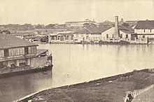
 Casco
barges, steamers, and other sailing vessels in Pasig in 1917
Casco
barges, steamers, and other sailing vessels in Pasig in 1917
 The Pasig River in 1899
 Aerial view of
Fort William McKinley
and the Pasig River,
c.
1930s
Aerial view of
Fort William McKinley
and the Pasig River,
c.
1930s
 The
Laguna de Bay
was a Pasig River
steamer
operated by a Spanish company, and was a type of vessel immortalized in
Jose Rizal
's novels. It is shown here after its conversion into an American
gunboat
. The modification of civilian vessels for war by fitting artillery pieces had previously been practiced by the Philippine and Spanish navies. The modern counterparts of the Pasig steamers are the
Pasig water buses.
The
Laguna de Bay
was a Pasig River
steamer
operated by a Spanish company, and was a type of vessel immortalized in
Jose Rizal
's novels. It is shown here after its conversion into an American
gunboat
. The modification of civilian vessels for war by fitting artillery pieces had previously been practiced by the Philippine and Spanish navies. The modern counterparts of the Pasig steamers are the
Pasig water buses.
 The Pasig River in 1900
The Pasig River served as an important means of transport; it was
Manila
's lifeline and center of economic activity. Some of the most prominent kingdoms in
early Philippine history
, including the kingdoms of
Namayan
,
Maynila
, and
Tondo
grew up along the banks of the river, drawing their life and source of wealth from it. When the Spanish established Manila as the capital of their colonial properties in the Far East, they built the walled city of
Intramuros
on the southern bank of the Pasig River near its mouth.
Pollution
[
edit
]
After
World War II
, massive population growth, infrastructure construction, and the dispersal of economic activities to Manila's suburbs left the river neglected. The banks of the river attracted informal settlers and the remaining factories dumped their wastes into the river, making it effectively a huge sewer system. Industrialization had already polluted the river.
[18]
In the 1930s, observers noticed the increasing pollution of the river, as fish migration from Laguna de Bay diminished. People ceased using the river's water for laundering in the 1960s, and ferry transport declined. By the 1970s, the river started to emanate offensive smells, and in the 1980s, fishing in the river was prohibited. In 1990, the Pasig River was considered
biologically dead
by the
Danish International Development Agency
.
[19]
[18]
It is estimated that about 60-65 percent of the pollution in the Pasig River comes from household waste disposed into the tributaries of the river. Increasing poverty in the rural areas in Philippines has driven migration to Metro Manila in search of better opportunities. This resulted in rapid urban growth, congestion and overcrowding of land and along the riverbanks, making the river and its tributaries a dumping ground for informal settlers living there.
About 30?35 percent of the river pollution is generated from industries locating close to the river (such as tanneries, textile mills, food processing plants, distilleries, and chemical and metal plants), some of which do not have water treatment facilities which are capable of removing heavy metal pollutants. The rest of the pollutants consist of solid waste dumped into the rivers. Metro Manila has been reported to produce as much as 7,000 metric tons (6,900 long tons; 7,700 short tons) of garbage per day.
[20]
In a study conducted by the researchers from
Polytechnic University of the Philippines
, the river is also contaminated with
microplastics
.
[21]
Rehabilitation efforts
[
edit
]
Efforts to revive the river began in December 1989 with the help of
Danish
authorities. The Pasig River Rehabilitation Program (PRRP) was established, with the
Department of Environment and Natural Resources
(DENR) as the main agency with the coordination of the Danish International Development Assistance (DANIDA).
[22]
In 1999, President
Joseph Estrada
signed Executive Order No. 54 establishing the
Pasig River Rehabilitation Commission
(PRRC) to replace the old PRRP with additional expanded powers such as managing of wastes and resettling of squatters.
[22]
The PRRC was abolished in November 2019, with its functions and powers being transferred to the Manila Bay Task Force, DENR,
Department of Housing and Urban Development
,
Metropolitan Manila Development Authority
(MMDA), and the
Department of Public Works and Highways
(DPWH).
[23]
In 2010, the television network
ABS-CBN
and PRRC headed by ABS-CBN Foundation-Bantay Kalikasan Director
Gina Lopez
? currently serving as a chairperson of PRRC ? launched a
fun run
fund-raising activity called "
Run for the Pasig River
" held every month of October. The proceeds from the fun run will serve as a fund for the "
Kapit-bisig para sa Ilog Pasig
" (Collaborate for the Pasig River) rehabilitation project of the Pasig River.
[
citation needed
]
In October 2018, the PRRC won the first Asia Riverprize, in recognition of its efforts to rehabilitate the Pasig River.
[24]
[25]
According to the PRRC, aquatic life has returned to the river.
[24]
On April 20, 2021,
San Miguel Corporation
announced that it would initiate a clean-up of the Pasig River in May 2021. SMC will also work with the DENR and the DPWH in this river cleanup.
[26]
The river cleanup is part of San Miguel Corporation's
?
95 billion
Pasig River Expressway
project.
Pasig River Esplanade
[
edit
]
On January 17, 2024, the
Bongbong Marcos administration
inaugurated its Pasig Bigyang Buhay Muli (PBBM;
lit.
'
Give Life to Pasig Again
'
) project, aiming to revitalize the Pasig River through the development of linear parks, walkways, bikeways, and commercial developments. The program also aims to improve the existing Pasig River Ferry System through the addition of more ferry boats and stations.
[27]
Marcos inaugurated on January 17, 2024 the "Pasig River Esplanade", the first phase of the
?18-billion
Pasig River Urban Development of the
Rehabilitation of the Pasig River
. The Inter-Agency Council for the Pasig River Urban Development (IAC-PRUD) per
Human Settlements and Urban Development
Secretary
Jose Acuzar
announced that it will build eight more esplanades in other parts of the river. The 500-meter (1,600 ft)
embankment
behind the Manila Central Post Office features the
promenade
which will be 25 kilometers (16 mi) long on each side of the Pasig River.
[28]
[29]
Gallery
[
edit
]
-
Barge on the Pasig River
-
The Pasig River near Quiapo
-
-
View from Guadalupe Bridge
-
The Pasig River with the Old Post Office Building
-
Boat transportation along the Pasig River
-
Pasig River Esplanade
-
Pasig River Esplanade at night
-
Pasig River with
Circuit Makati
See also
[
edit
]
References
[
edit
]
- ^
a
b
Tuddao Jr., Vicente B. (September 21, 2011).
"Water Quality Management in the Context of Basin Management: Water Quality, River Basin Management and Governance Dynamics in the Philippines"
(PDF)
.
www.wepa-db.net
. Department of Environment and Natural Resources
. Retrieved
April 10,
2017
.
- ^
a
b
c
d
e
"House Bill No. 5641"
(PDF)
. May 7, 2015.
- ^
a
b
"Process of resurrection continues for once-dead Pasig River"
. April 20, 2019.
- ^
Villamor, Carmelita, et.,al. (February 2009) "Biodiversity Assessment of Pasig River and Its Tributaries: Ecosystems Approach (Phase One)."Department of Environment and Natural Resources ? Ecosystems Research and Development Bureau (DENR-ERDB).
- ^
Senior, Ira Karen Apanay (August 15, 2009).
"Pasig river is feeding ground for exotic species, study shows"
. The Manila Times
. Retrieved
April 25,
2022
– via PressReader.
- ^
"Pasig City History"
.
www.pasigcity.gov.ph
. Retrieved
August 14,
2022
.
- ^
"Pasig City"
. Archived from
the original
on September 24, 2015
. Retrieved
February 16,
2015
.
- ^
"NEDA Board Approved Projects (Aquino Administration) From June 2010 to June 2017"
(PDF)
.
National Economic and Development Authority Official Website
. February 28, 2017. Archived from
the original
(PDF)
on July 23, 2017
. Retrieved
September 6,
2018
.
- ^
Calucin, Diann Uvy (July 20, 2023).
"Manila LGU inaugurates 'Tulay Pangarap' in Sta. Ana"
.
Manila Bulletin
. Retrieved
July 22,
2023
.
- ^
a
b
c
d
e
The Reign of Greed by Jose Rizal
. Retrieved
August 14,
2022
.
- ^
"[Laguna de Bay] Lake Elevation"
. Laguna Lake Development Authority. Archived from
the original
on September 2, 2009.
- ^
"Laguna de Bay Masterplan"
. Laguna Lake Development Authority. Archived from
the original
on September 29, 2007.
- ^
Obermaier, Hugo (1924).
Fossil man in Spain
. Internet Archive. New Haven, Pub. for the Hispanic Society of America by the Yale University Press.
- ^
Perez de Barradas, Jose (1945).
"Estado actual de las investigaciones sobre el hombre fosil"
.
Boletin de la Real Academia de la Historia
(in Spanish).
- ^
Romeo, Luigi (January 1, 1979).
Ecce Homo! A Lexicon of Man
. John Benjamins Publishing.
ISBN
978-90-272-7452-6
.
- ^
Roy, Sarat Chandra (1930).
Man In India Vol.10
.
- ^
Sanchez, Domingo Sanchez y (1921).
Un craneo humano prehistorico de Manila (Filipinas)
(in Spanish). Museo Nacional de Ciencias Naturales.
- ^
a
b
Murphy, Denis; Anana, Ted (2004).
"Pasig River Rehabilitation Program"
.
Habitat International Coalition
. Archived from
the original
on October 12, 2007.
- ^
Suh, Kyung-duck; Cruz, Eric C.; Tajima, Yoshimitsu (September 21, 2017).
Asian And Pacific Coast 2017 ? Proceedings Of The 9th International Conference On Apac 2017
. World Scientific. p. 862.
ISBN
978-981-323-382-9
. Retrieved
April 25,
2022
.
- ^
Gorme, Joan B.; Maniquiz, Marla C.; Song, Pum; Kim, Lee-Hyung (2010).
"The Water Quality of the Pasig River in the City of Manila, Philippines: Current Status, Management and Future Recovery"
.
Environmental Engineering Research
.
15
(3): 173?179.
doi
:
10.4491/eer.2010.15.3.173
.
- ^
Deocaris, Chester C.; Allosada, Jayson O.; Ardiente, Lorraine T.; Bitang, Louie Glenn G.; Dulohan, Christine L.; Lapuz, John Kenneth I.; Padilla, Lyra M.; Ramos, Vincent Paulo; Padolina, Jan Bernel P. (January 22, 2019).
"Occurrence of microplastic fragments in the Pasig River"
.
H2Open Journal
.
2
(1): 92?100.
doi
:
10.2166/h2oj.2019.001
.
ISSN
2616-6518
.
- ^
a
b
Santelices, Menchit.
"A dying river comes back to life"
.
Philippine Information Agency
. Archived from
the original
on March 16, 2008.
- ^
Villanueva, Rhodina; Ramirez, Robertzon (November 15, 2019).
"Duterte Abolishes Pasig River Rehabilitation Commission"
.
Philstar.com
. Retrieved
June 26,
2022
.
- ^
a
b
"
'Instagrammable?' Restored Pasig River wins international environment award"
.
ABS-CBN News
. October 17, 2018
. Retrieved
October 20,
2018
.
- ^
"Pasig River rehabilitation program feted in first Asia RiverPrize awards"
.
GMA News Online
. October 17, 2018
. Retrieved
October 20,
2018
.
- ^
"Pasig River cleanup to start in May"
.
CNN Philippines
. April 20, 2021. Archived from
the original
on April 20, 2021
. Retrieved
April 21,
2021
.
- ^
"PBBM leads efforts to bring Pasig River back to its old glory through "Pasig Bigyang Buhay Muli" project"
.
Presidential Communications Office
. January 17, 2024.
- ^
"Pasig River Esplanade is Manila's latest IG-worthy spot"
.
ABS-CBN News and Current Affairs
. February 7, 2024.
- ^
Domingo, Katrina (January 17, 2024).
"Initial phase of P18-B Pasig River mixed-use park unveiled to the public"
.
ABS-CBN News and Current Affairs
.
External links
[
edit
]