District in Kerala, India
District in Kerala, India
Kasaragod
(
pronounced
[kaːs?r?oː???]
ⓘ
and
Malayalam
:
Kanhirakode
,
[1]
English
:
Kassergode
,
Tulu
:
Kasrode
,
kannada
: kasaragoodu
[10]
) is one of the 14
districts
in the southern
Indian
state of
Kerala
. Its northern border
Thalappady
is located just 9 km south to
Ullal
, which is the southernmost portion of the major port city
Mangalore
, on the southwestern
Malabar coast
of India.
Kasaragod is the northernmost district of Kerala and is also known as
Saptha Bhasha Sangama Bhoomi
(The place where Seven languages meets)
The district is situated on the rich biodiversity of the
Western Ghats
. It was a part of the
Kannur district
of Kerala until 24 May 1984. It also remains the last formed district of kerala to date. The district is bounded by
Dakshina Kannada
district to the north,
Western Ghats
to the northeast,
Kodagu district
to the southeast,
Kannur district
to the south, and the
Arabian Sea
to the west. Kasaragod district has the maximum number of rivers in Kerala - 12.
[11]
Kasaragod
town is located on the estuary where the
Chandragiri River
, which is also the longest river in the district, empties into
Arabian Sea
. Kasaragod is home to several forts which include
Arikady fort
,
Bekal Fort
,
Chandragiri Fort
, and
Hosdurg Fort
(Puthiyakotta Fort).
Bekal Fort
is also the largest fort in Kerala. The historic hill of
Ezhimala
is located on the southern portion of
Kavvayi Backwaters
of
Nileshwaram
.
Talakaveri
, which is home to
Talakaveri Wildlife Sanctuary
where the 805 km long
Kaveri River
originates, is located closer to
Ranipuram
in Kerala-
Karnataka
border.
Robert Caldwell
describes the extent of Malayalam in the late 19th century as extending from
Chandragiri fort
and
Chandragiri river
in the north to
Neyyar river
beyond
Thiruvanantapuram
in the south.
[12]
Tulunad, where Tulu is traditionally spoken, is said to be bound on the south by the Chandragiri river and fort, thus including Kasaragod city within the Tulunad region.
[13]
Historian N. Shyam Bhat states that at present, the Tulu nadu can linguistically be said to extend to the south up to the
river Chandragiri
or Payaswini, and culturally up to the
Kavvayi river
in the south, as the region between the Chandragiri and Kavai (Kavvayi) rivers presents the characteristics of a twilight zone between the
Malayalam
and
Tulu
speaking areas.
[14]
Kasargod is also the first district in India to have official symbols-official tree, flower, bird, species.
[9]
Etymology
[
edit
]
Until the 16th century CE, Kasargod town was known by the name
K?nnirakk???
(meaning, 'The land of
k?nnira
Trees') in
Malayalam
.
[1]
Kasaragod
is the Kannada version of
K?nnirakk???
.
History
[
edit
]
Ancient period
[
edit
]
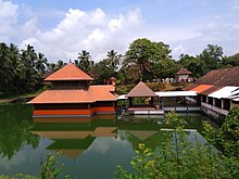 Ananthapadmanabhaswamy temple
at Ananthapura,
Kumbla
Ananthapadmanabhaswamy temple
at Ananthapura,
Kumbla
The Ancient Tamil Works of Sangam Age records that the area covering the district was part of Puzhinadu, which consists of the coastal belt from
Kozhikode
to
Mangalore
. Politically the area was part of the
Ezhimala Kingdom
with its Capital at
Ezhimala
in present day Kannur district. The most famous King of Ezhimala was Nannan whose kingdom extended up to
Gudalur
and northern parts of Coimbatore. Poozhinad, along with Karkanad which included the eastern regions of Ezhimala dynasty (
Wayanad
-
Gudalur
region with some portions of
Kodagu
), had its capital at
Ezhimala
. The
Mooshaka Kings were considered descendants of Nannan. By the 14th century,
Mooshaka Kingdom
was known as Kolathirinad and the Rulers as Kolathiris.
The Kolathunad Kingdom at the peak of its power reportedly extended from
Netravati River
(
Mangalore
) in the north
[15]
to
Korapuzha
(
Kozhikode
) in the south with
Arabian Sea
on the west and
Kodagu
hills on the eastern boundary, also including the isolated islands of
Lakshadweep
in Arabian Sea.
[16]
Medieval period
[
edit
]
 Malik Dinar Mosque
,
Kasaragod
, is one of the oldest mosques in India.
Malik Dinar Mosque
,
Kasaragod
, is one of the oldest mosques in India.
 Maipady palace
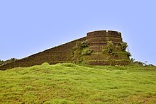 Arikady fort
at
Kumbla
Arikady fort
at
Kumbla
Ramacharitam
, probably the oldest literary work written in
Old Malayalam
, which dates back to the 12th century CE, is thought to have been written in Kasargod district as its manuscripts were discovered from
Nileshwaram
and the poem mentions about
Ananthapura Lake Temple
in
Kumbla
in detail.
[17]
Kasaragod was known to the
Arabs
by the name
Harkwillia
.
[10]
Malik Dinar Mosque
at
Kasaragod
town is one of the oldest mosques in the
Indian subcontinent
. According to
Qissat Shakarwati Farmad
, the
Masjids
at
Kodungallur
,
Kollam
,
Madayi
,
Barkur
,
Mangalore
, Kasaragod,
Kannur
,
Dharmadam
,
Panthalayini
, and
Chaliyam
, were built during the era of
Malik Dinar
, and they are among the oldest
Masjid
s in the
Indian subcontinent
.
[18]
It is believed that
Malik Dinar
died at
Thalangara
in Kasaragod town.
[19]
Many Arab travelers visiting Kerala between the 9th and the 14th centuries visited Kasaragod, being an important trade centre then. Duarte Barbosa, a Portuguese traveler who visited
Kumbla
, near
Kasargod
in 1514 recorded that rice being exported for coir to
Maldives
.
[10]
According to Barbosa, the people in the southwestern Malabar coast of India from
Chandragiri
in the north to
Kanyakumari
in the south spoke a unique language, which they called as "Maliama" (
Malayalam
).
[20]
Until the 16th century CE, Kasargod town was known by the name
Kanhirakode
(may be by the meaning, 'The land of
Kanhira
Trees') in
Malayalam
.
[1]
The
Kumbla
dynasty, who swayed over the land of southern
Tulu Nadu
wedged between
Chandragiri River
and
Netravati River
(including present-day Taluks of
Manjeshwar
and
Kasaragod
) from
Maipady Palace
at
Kumbla
, had also been vassals to the
Kolathunadu
kingdom of
North Malabar
, before the
Carnatic
conquests of
Vijayanagara Empire
.
[21]
The Kumbla dynasty had a mixed lineage of
Malayali
Nairs
and
Tuluva Brahmins
.
[22]
They also claimed their origin from
Cheraman Perumals
of Kerala.
[22]
Francis Buchanan-Hamilton
states that the customs of Kumbla dynasty were similar to those of the contemporary
Malayali
kings.
[22]
The
Kolathiri
Dominion emerged into independent 10 principalities i.e.,
Kadathanadu
(
Vadakara
),
Randathara
or Poyanad (
Dharmadom
),
Kottayam
(
Thalassery
),
Nileshwaram
, Iruvazhinadu (
Panoor
),
Kurumbranad
etc., under separate royal chieftains due to the outcome of internal dissensions.
[23]
Many portions of the present-day
Hosdurg taluk
(Kanhangad) and
Vellarikundu
were parts of the
Nileshwaram
dynasty, who were relatives to both
Kolathunadu
as well as
Zamorin
of
Calicut
, in the early medieval period.
[24]
The areas north to the
Chandragiri river
(present-day Taluks of Manjeshwaram and Kasaragod) were ruled by the Kumbala dynasty. According to local legends, the region between Talapadi and Kavvayi rivers which constituted the erstwhile Kasaragod taluk, consisted of 32
Tulu
and 32
Malayalam
villages.
[22]
Kannada
kingdoms focused on
Kasaragod
in the 16th century CE. The
Vijayanagara empire
attacked and annexed Kasaragod from the
Kolathiri
Raja
with
Nileshwaram
as one of the capital in the 16th century. During the decline of the Vijayanagara empire, the administration of this area was vested with
Ikkeri Nayakas
.
[10]
At the onset of collapse of the Vijayanagara empire,
Venkappa Nayaka
declared independence to Ikkery. Kumbla, Chandragiri, and Bekal are considered to be the chain of forts constructed or renovated by
Shivappa Nayaka
.
[10]
The
Chandragiri Fort
is built on the southern bank of the estuary of
Chandragiri River
, just opposite to Kasaragod town. The
Bekal Fort
at
Bekal
,
Pallikkara
, which is situated in the midway between
Kasaragod
and
Kanhangad
, and is also largest fort in Kerala, was built in 1650 by
Shivappa Nayaka
of
Keladi
.
[25]
Modern period
[
edit
]
 A map of
Malabar District
(Malayalam district) drawn by
Francis Buchanan-Hamilton
in 1807.
Kasaragod
region to the south of Payaswini/Chandragiri river of
South Canara
was also included in Malayalam region (just above the blue shaded region).
A map of
Malabar District
(Malayalam district) drawn by
Francis Buchanan-Hamilton
in 1807.
Kasaragod
region to the south of Payaswini/Chandragiri river of
South Canara
was also included in Malayalam region (just above the blue shaded region).
 Road sign in
Kasaragod
town
Road sign in
Kasaragod
town
 Sunset at
Valiyaparamba
beach
Sunset at
Valiyaparamba
beach
Francis Buchanan, the family doctor of
Arthur Wellesley
, visited Kasaragod in 1800.
[10]
In his travelogue, he recorded information on places like Athiraparambu, Kavvai,
Nileshwaram
,
Bekal
,
Chandragiri
and
Manjeshwar
.
[10]
Hosdurg
and Vellarikundu is part of Kolathunadu (south of Chandragiri river) and Kasargod and Manjeshwaram is in the
Tulu Nadu
region (north of Chandragiri river). On 19 January 1801, Francis speaks of visiting a Siva temple at Pulla (Pallikere), beyond which, the country rises into open rising lands, all the way to Chandragiri river and Chandragiri fort, which he describes as the northern border of the Malayala. He says that the country on the north of the Chandragiri fort and river is called by Hindus as Tuluva, the Tulu country.
[26]
According to Stuart (1895) “The Kasargod taluk originally formed the southern portion of the ancient Tulua kingdom and was separated from the kingdom of Kerala by the Chandragiri river which was formerly called “Perumpula”; the river on which the fort stands is shallow but very wide and formed the southern boundary of the ancient Tulva kingdom. The nayars and the other females of the Kasargod taluk of south Canara, are prohibited from crossing the river.”
[27]
In 1763,
Hyder Ali
raided Bedanoor (Bidnur), the capital of the Ikkery Naiks. His son
Tippu Sultan
raided much of
Malabar
region in Kerala. As per the
Treaty of Seringapatam
of 1792, Tippu surrendered Malabar, except
Kanara
to the
British
. The British occupied Kanara only after the death of Tippu Sultan.
[10]
it is said that
Kinavoor Molom
(Sree Dharma Shashtha Temple) is belonging to
Karinthalam
(one of 64 Brahmin villages in old Kerala).
Before the formation of Kerala, Kasargod was a part of
South Canara
district of erstwhile
Madras Presidency
. Initially
South Canara
was included in the
Bombay presidency
.
[28]
Later on 16 April 1862, South Canara was transferred to
Madras Presidency
and
Kasaragod
taluk was formed by replacing the erstwhile
Bekal
taluk.
[28]
However, in the 19th century CE, Kasargod Taluk witnessed many struggles to separate the region from South Canara and to merge it with the
Malabar District
as it was the only Malayalam-majority region in South Canara. Kasaragod was the second-most populated Taluk in
South Canara
only after to
Mangalore taluk
, and also the second-largest Taluk.
[29]
Kasargod became a part of
Kannur district
of
Kerala
following the reorganization of states and the formation of Kerala on 1 November 1956.
[30]
Later Kasargod was divided into two Taluks for the ease of administration - Kasargod and Hosdurg. Kasargod was declared a district in 1984. The inclusion of Kasaragod with Kerala has been a contentious issue as there is a sizeable population that speaks Tulu and Kannada. At the time of 1951 Census of India, only 72.0% of the district's population chose their mother tongue as
Malayalam
.
[31]
14.2% chose
Tulu
and 6.3% chose Kannada.
[31]
But it is noted that as per the 2011 census report only 8.8% and 4.2% of the total population in the district speak Tulu and Kannada respectively as their mother tongue. In 2012, the
Second Oommen Chandy ministry
appointed a commission under the leadership the former Chief Secretary P. Prabhakaran to study about the backwardness and issues faced by this northernmost district of Kerala and to draw up special package for the district.
[32]
In 2013, two more Taluks, namely Manjeshwaram and Vellarikundu were formed in the district.
[33]
Geography
[
edit
]
 Manjeshwaram
harbour
Manjeshwaram
harbour
The district is the northernmost district of the State of Kerala. Kasargod is located at
12°30′N
75°00′E
/
12.5°N 75.0°E
/
12.5; 75.0
.
[34]
It has an average elevation of 19 metres (62 feet).
Ranipuram
or Madathumala (1016m) peak is the highest peak in the Kasargod district of Kerala, located in the Ranipuram Wildlife Sanctuary.
Climate
[
edit
]
Kasaragod has a
tropical climate
.
| Climate data for Kasargod
|
| Month
|
Jan
|
Feb
|
Mar
|
Apr
|
May
|
Jun
|
Jul
|
Aug
|
Sep
|
Oct
|
Nov
|
Dec
|
Year
|
| Mean daily maximum °C (°F)
|
33.1
(91.6)
|
33.3
(91.9)
|
33.9
(93.0)
|
34.3
(93.7)
|
33.4
(92.1)
|
29.8
(85.6)
|
28.7
(83.7)
|
28.8
(83.8)
|
30.1
(86.2)
|
31.2
(88.2)
|
32.7
(90.9)
|
33.1
(91.6)
|
31.9
(89.4)
|
| Mean daily minimum °C (°F)
|
21.1
(70.0)
|
21.9
(71.4)
|
23.7
(74.7)
|
24.9
(76.8)
|
24.9
(76.8)
|
23.5
(74.3)
|
23
(73)
|
23
(73)
|
23.2
(73.8)
|
23.2
(73.8)
|
22.7
(72.9)
|
21.3
(70.3)
|
23.0
(73.4)
|
| Average
precipitation
mm (inches)
|
0.8
(0.03)
|
0
(0)
|
17.3
(0.68)
|
32.7
(1.29)
|
182.9
(7.20)
|
1,010.5
(39.78)
|
1,002.8
(39.48)
|
663.6
(26.13)
|
246.5
(9.70)
|
222.6
(8.76)
|
69
(2.7)
|
12.4
(0.49)
|
3,461.1
(136.24)
|
| Source:
Meo Weather
|
Rivers
[
edit
]
Kasaragod district has the largest number of rivers in Kerala - 12.
[11]
All of them are west-flowing rivers.
[35]
The longest of them is
Chandragiri River
(105 km long).
Kasaragod
town is located on the estuary of Chandragiri river. It empties into the
Arabian Sea
at
Thalangara
.
[35]
The
Chandragiri Fort
is built on its bank. The river originates at Pattimala in
Kodagu
(Coorg).
[35]
The smallest river of Kerala is also in the district.
Administration
[
edit
]
 Kanhangad
Municipal Office
Kanhangad
Municipal Office
Kasargod district consists of two revenue subdivisions- Kasargod and Kanhangad. For sake of rural administration, 38 Gram Panchayats are combined in 6 Blocks, which together form the Kasargod District Panchayat. For the sake of urban administration, 3 municipal towns are there.
[37]
For the representation of Kasargod in
Kerala Legislative Assembly
, there are 5 assembly constituencies. These are included in the
Kasaragod (Lok Sabha constituency)
.
[37]
[38]
The district is further divided into 128 villages which together form 4 subdistricts.
[39]
Major Towns
[
edit
]
The major towns of the district include:
- Manjeshwaram taluk:
Manjeshwar
,
Uppala
,
Kumbla
,
Puthige
,
Paivalike
,
Vorkady
,
Meenja
,
Perla
,
Hosabettu
,
Thalapady
- Kasaragod taluk:
Kasaragod
,
Mogral Puthur
,
Badiyadka
,
Cherkala
,
Bellur
,
Chattanchal
- Hosdurg taluk:
Cheruvathur
,
Nileshwaram
,
Ajanur
Kanhangad
,
Udma
,
Pullur
,
Thrikaripur
,
Bekal
,
Pilicode
- Vellarikund taluk:
Vellarikundu
,
Malom
,
Panathur
Revenue divisions
[
edit
]
Manjeshwaram
and
Kasargod
subdistricts (Taluks) are included in the Kasaragod revenue subdivision whereas the remaining two Taluks are included in the Kanhangad subdivision.
 Taluks in Kasargod
Political divisions
[
edit
]
 Local bodies in Kasaragod district
State legislature
[
edit
]
Parliament
[
edit
]
Transport
[
edit
]
 Kasaragod railway station
lies on
Mangalore
-
Shoranur
railway line in
Palakkad railway division
.
Kasaragod railway station
lies on
Mangalore
-
Shoranur
railway line in
Palakkad railway division
.
The
National Highway 66
which connects the western coast of India from
Mumbai
to
Kanyakumari
passes through coastal area of the district connecting the major coastal towns of
Manjeshwar
,
Uppala
,
Kumbla
,
Kasaragod
,
Udma
,
Bekal
,
Kanhangad
,
Nileshwaram
, and
Thrikaripur
.
[42]
[43]
[44]
It enters the district at
Thalappady
and goes out through
Payyanur
. There are
State highways
starting/ending at
Kasaragod
and
Kanhangad
.
[45]
Total length of
Major District Road
(MDR) is around 1460 km and it accounts for around 11.2 km of MDR for every 10,000 people in the district.
[46]
The
Kerala State Road Transport Corporation
(KSRTC) has stations to operate its service in the district.
[47]
The railway goes through coastal area.
Kasaragod railway station
lies in
Palakkad railway division
of southern zone on
Mangalore
-
Shoranur
line.
[48]
Kasaragod district is home to
3 out of 13 minor ports in Kerala
-
Manjeshwar
, Kasaragod, and
Nileshwaram
.
[49]
The nearest international airports are situated at
Mangalore
(65 km away) and
Kannur
(110 km away).
Demographics
[
edit
]
Historical population
| Year
| Pop.
| ±% p.a.
|
|---|
| 1901
| 231,280
| ?
|
|---|
| 1911
| 247,467
| +0.68%
|
|---|
| 1921
| 256,931
| +0.38%
|
|---|
| 1931
| 302,043
| +1.63%
|
|---|
| 1941
| 342,301
| +1.26%
|
|---|
| 1951
| 411,031
| +1.85%
|
|---|
| 1961
| 512,146
| +2.22%
|
|---|
| 1971
| 683,020
| +2.92%
|
|---|
| 1981
| 872,741
| +2.48%
|
|---|
| 1991
| 1,071,508
| +2.07%
|
|---|
| 2001
| 1,204,078
| +1.17%
|
|---|
| 2011
| 1,307,375
| +0.83%
|
|---|
| 2018
| 1,390,894
| +0.89%
|
|---|
| source:
[50]
|
According to the 2018 Vital Statistics published by the
Government of Kerala
, Kasargod district has a
population
of 1,390,894,
[3]
roughly equal to the nation of
Trinidad and Tobago
[51]
or the US state of
New Hampshire
.
[52]
The
2011 Census of India
, gives the district a ranking of 375th in India (out of a total of
640
).
[53]
The district has a population density of 654 inhabitants per square kilometre (1,690/sq mi).
[53]
Its
population growth rate
over the decade 2001?2011 was 8.18%.
[53]
Kasaragod has a
sex ratio
of 1080
females
for every 1000 males,
[53]
and a
literacy rate
of 90.09%.
[54]
Scheduled Castes and Scheduled Tribes make up 4.08% and 3.74% of the population respectively.
[53]
The
Kerala Tulu Academy
, which promotes
Tulu language
and literature, is functioned at Hosangadi in district.
Languages of Kasaragod district (2011)
[4]
Others (1.26%)
Kasaragod district majorly consists of
Malayalam
speakers who form 82.69% of the population.
Tulu
and
Kannada
speakers concentrated in the Northern parts of the district like
Manjeshwar
,
Uppala
,
Enmakaje
,
Badiyadka
,
Kumbla
and
Seethangoli
form a significant linguistic minority with 8.77% and 4.23% each. Other languages spoken here include
Marathi
(1.76%) and
Konkani
(1.29%).
[4]
Education
[
edit
]
 The
Central University of Kerala
is situated in the district.
The
Central University of Kerala
is situated in the district.
 The
Central Plantation Crops Research Institute
at Kasaragod was established in 1916.
The
Central Plantation Crops Research Institute
at Kasaragod was established in 1916.
 The
Government College Kasaragod
was established in 1957.
The
Government College Kasaragod
was established in 1957.
Kasargod district comes under the jurisdiction of
Kannur University
.
- The
Central Plantation Crops Research Institute
at
Kasaragod
was established in 1916.
[55]
- Government College Kasaragod
was established in 1957.
- The
Central University of Kerala
was established in 2009.
[56]
[57]
- Malik Deenar Institute of Management Studies is located at Seethamgoly, Kasaragod.
[58]
- Lal Bahadur Shastry college of engineering, Kasaragod, was established in 1993.
- College of Engineering Trikaripur
was established in 2000.
[59]
- Khansa Women's College For Advanced Studies, Kasaragod
- Jamia Sa Adiya Arts and Science College, Kasaragod
- Sharaf Arts & Science College, Padanna
- Zainab Memorial B.Ed Centre, Kasaragod
- Peoples Arts & Science College, Munnad, Kasaragod
- Co-operative Arts & Science College, Badiadka, Kasaragod
- St. Gregorios College of Engineering, Perla, Kasaragod
Development
[
edit
]
 Thrikaripur
town
Thrikaripur
town
Kasaragod district is the northernmost district of Kerala, which is far away from
Thiruvananthapuram
, the state headquarters, which is located in the southernmost tip of state.
Manjeshwaram
town is located about 600 km north of the state headquarters
Thiruvananthapuram
, about 30 km south of
Mangalore
, about 350 km west of
Bangalore
, the headquarters of the neighbouring state
Karnataka
, and about 950 km south of
Mumbai
city. In 2012, the
Second Oommen Chandy ministry
appointed a commission under the leadership of the former Chief Secretary P. Prabhakaran to study about the backwardness and issues faced by this northernmost district of Kerala and to draw up a special package for the district.
[32]
In 2013, two more taluks, namely Manjeshwaram and Vellarikundu were formed in the district.
[33]
Before it the district had only two Taluks. The decision to implement a gas-based powerplant at
Cheemeni
was taken by the
second Chandy government
.
[60]
A government medical college was allowed for Kasaragod district, as a part of the government's new policy to establish at ensure availability of at least one Government Medical College in all the
14 districts
of the state in 2013.
[61]
[62]
Tourism
[
edit
]
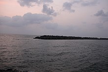
 Edayilakkad
island in
Valiyaparamba
Edayilakkad
island in
Valiyaparamba
Notable people
[
edit
]
 Panathur
is an important hilly town in the district (Closer to
Western Ghats
)
Panathur
is an important hilly town in the district (Closer to
Western Ghats
)
 Badiyadka
town during night
Badiyadka
town during night
Localities
[
edit
]
See also
[
edit
]
References
[
edit
]
- ^
a
b
c
d
S. Muhammad Hussain Nainar (1942).
Tuhfat-al-Mujahidin: An Historical Work in The Arabic Language
. University of Madras.
- ^
"Kasargod - the land of seven languages"
.
invest kerala
. Government of Kerala
. Retrieved
12 September
2020
.
- ^
a
b
Annual Vital Statistics Report - 2018
(PDF)
. Thiruvananthapuram: Department of Economics and Statistics, Government of Kerala. 2020. p. 55. Archived from
the original
(PDF)
on 2 November 2021
. Retrieved
29 October
2020
.
- ^
a
b
c
"Table C-16 Population by Mother Tongue: Kerala"
.
www.censusindia.gov.in
.
Registrar General and Census Commissioner of India
.
- ^
a
b
"Table C-01: Population by religious community: Kerala"
.
Census of India
.
Registrar General and Census Commissioner of India
. 2011.
- ^
"Sex Ratio"
(PDF)
.
censusindia.gov.in
.
- ^
"Literacy"
(PDF)
.
censusindia.gov.in
.
- ^
"Kerala | UNDP in India"
.
UNDP
.
- ^
a
b
Bureau, The Hindu (20 October 2023).
"Kasaragod becomes first district in India to declare official tree, flower, bird, species"
.
The Hindu
.
ISSN
0971-751X
. Retrieved
29 October
2023
.
- ^
a
b
c
d
e
f
g
h
"Kasaragod History"
. Government of Kerala. Archived from
the original
on 25 September 2008
. Retrieved
11 March
2009
.
- ^
a
b
"Rivers in Kasargod"
.
Kerala Tourism
. Retrieved
12 September
2020
.
- ^
Caldwell, Robert (1998).
A Comparative Grammar of the Dravidian Or South-Indian Family of Languages
. Asian Educational Services. pp. 16, 17?19, 20, 21?25.
ISBN
978-81-206-0117-8
.
- ^
Steever, Sanford B. (15 April 2015).
The Dravidian Languages
. Taylor & Francis. pp. 158?159.
ISBN
9781136911644
.
- ^
Bhat, N. Shyam (1998).
South Kanara, 1799-1860, A Study in Colonial Administration and Regional Response
. Mittal Publications. p. 6.
ISBN
9788170995869
.
- ^
Sreedhara Menon, A. (2007).
Kerala Charitram
(2007 ed.). Kottayam: DC Books. p. 175.
ISBN
978-8126415885
. Retrieved
19 July
2020
.
- ^
District Census Handbook, Kasaragod (2011)
(PDF)
. Thiruvananthapuram: Directorate of Census Operation, Kerala. p. 9.
- ^
SLM MA Mal Aadyaka
sdeuoc.ac.in
Archived
8 June 2021 at the
Wayback Machine
- ^
Prange, Sebastian R.
Monsoon Islam: Trade and Faith on the Medieval Malabar Coast.
Cambridge University Press, 2018. 98.
- ^
Pg 58, Cultural heritage of
Kerala
: an introduction, A. Sreedhara Menon, East-West Publications, 1978
- ^
Barbosa, Duarte (1989).
The Book of Duarte Barbosa: An Account of the countries bordering on the Indian Ocean and their inhabitants (Volume 2)
. Asian Educational Services. pp. 1?7.
ISBN
9788120604513
.
Per Barbosa, Malabar begins at the point where the kingdom of Narasyngua or Vijayanagar ends, that is at Cumbola (Cambola) on the Chandragiri river. But, as he (Barbosa) says, the Malayalam language extends as far north as the Chandragiri, and Malabar may be reckoned as extending south from this point to Cape Comorin.
- ^
M. Vijayanunni.
1981 Census Handbook- Kasaragod District
(PDF)
. Directorate of Census Operations, Kerala.
- ^
a
b
c
d
Sreedhara Menon, A. (2007).
A Survey of Kerala History
(2007 ed.). Kottayam: DC Books.
ISBN
9788126415786
.
- ^
Logan, William (2010).
Malabar Manual (Volume-I)
. New Delhi: Asian Educational Services. pp. 631?666.
ISBN
9788120604476
.
- ^
The Hindu staff reporter (21 November 2011).
"Neeleswaram fete to showcase its heritage"
.
The Hindu
. Retrieved
24 November
2016
.
- ^
"A Portion of Kasaragod's Bekal Forts Observation Post Caves in"
.
The Hindu
. 12 August 2019.
- ^
Buchanan, Francis Hamilton (1807).
A Journey from Madras Through the Countries of Mysore, Canara, and Malabar
. Cadell.
- ^
M., Amruth (2004).
"Forest-Agriculture Linkage and its Implications on Forest Management: A study of Delampady panchayat"
(PDF)
.
- ^
a
b
M. Vijayanunni.
1981 Census Handbook- Kasaragod District
(PDF)
. Directorate of Census Operations, Kerala. p. 11.
- ^
Government of Madras (1953).
1951 Census Handbook- South Canara District
(PDF)
. Madras Government Press.
- ^
"Kasargod After District Formation"
. Kasargod District. Archived from
the original
on 10 April 2009
. Retrieved
11 March
2009
.
- ^
a
b
J. I. Arputhanathan (1955).
South Kanara, The Nilgiris, Malabar and Coimbatore Districts (Village-wise Mother-tongue Data for Bilingual or Multilingual Taluks)
(PDF)
. Madras Government Press.
- ^
a
b
Roy Mathew (24 May 2012).
"Commission to draw up package for Kasaragod"
.
The Hindu
.
- ^
a
b
"12 new taluks to be formed in Kerala"
.
The Hindu
. 21 March 2013.
- ^
Falling Rain Genomics, Inc - Kasaragod
- ^
a
b
c
d
Government of India (2014?2015).
District Census Handbook - Kasaragod (Part-A) 2011
(PDF)
. Directorate of Census Operations, Kerala.
- ^
"Municipalities in Kasaragod"
.
Official website of Kasaragod district
. Retrieved
12 September
2020
.
- ^
a
b
"Administrative divisions of Kasaragod district"
.
Official website of Kasaragod district
. Retrieved
12 September
2020
.
- ^
"Niyamasabha constituencies of Kasargod"
.
ceo.kerala.gov.in
. Retrieved
12 September
2020
.
- ^
"Talukas in Kasargod district"
.
Kasargod district website
. Retrieved
12 September
2020
.
- ^
"Taluk-wise demography of Kasargod"
(PDF)
.
censusindia.gov.in
. Directorate of Census Operations, Kerala. pp. 79?98
. Retrieved
12 September
2020
.
- ^
"Villages in Kasargod"
.
kasargod.nic.in
. Retrieved
12 September
2020
.
- ^
"All new national highways to be made of concrete: Nitin Gadkari"
.
timesofindia-economictimes
.
- ^
"National Highway work gains speed in Kerala"
. 27 August 2017.
- ^
"Home"
.
- ^
"Economic review 2015"
(PDF)
. Retrieved
27 February
2016
.
[
permanent dead link
]
- ^
Government of Kerala (2021).
Economic Review 2020 - Volume I
(PDF)
. Thiruvananthapuram: Kerala State Planning Board.
- ^
"All about KSRTC"
. Keralartc.com. Archived from
the original
on 25 June 2018
. Retrieved
16 June
2018
.
- ^
"SALIENT FEATURES OF PALGHAT DIVISION"
(PDF)
.
sr.indianrailways.gov.in/
. Southern Railway.
- ^
Chandran 2018
, p. 424.
- ^
Decadal Variation In Population Since 1901
- ^
US Directorate of Intelligence.
"Country Comparison:Population"
. Archived from
the original
on 13 June 2007
. Retrieved
1 October
2011
.
Mauritius 1,303,717 July 2011 est.
- ^
"2010 Resident Population Data"
. U. S. Census Bureau. Archived from
the original
on 1 January 2011
. Retrieved
30 September
2011
.
New Hampshire 1,316,470
- ^
a
b
c
d
e
"District Census Hand Book: Kasaragod"
(PDF)
.
Census of India
.
Registrar General and Census Commissioner of India
.
- ^
"Literacy and Sex Ratio - 2011"
(PDF)
.
censusindia.gov.in
.
- ^
"Central Plantation Crops Research Institute(CPCRI)"
. cpcri
. Retrieved
24 September
2012
.
- ^
Description on official website
- ^
Prospectus of Central University of Kerala
- ^
"Malik Deenar Institute"
. Archived from
the original
on 18 August 2019
. Retrieved
3 June
2021
.
- ^
"CETKR | College Of Engineering Trikaripur"
.
cetkr.ac.in
. Retrieved
8 December
2017
.
- ^
"Kerala to get three gas-based power projects"
.
Projects Today
. 26 August 2013.
- ^
Special Currespondent (4 May 2019).
"MCI recognition for Manjeri medical college"
.
The Hindu
.
- ^
Staff Reporter (2 September 2013).
"A new government medical college in Kerala after 31 years"
.
The Hindu
.
- ^
Simran Gill (14 June 2020).
"5 Lesser Known Forts in India"
.
Outlook India
. Retrieved
12 September
2020
.
- ^
Divakaran, Kattakada (2005).
Kerala Sanchaaram
. Thiruvananthapuram: Z Library. p. 925.
- ^
"Proposal Submitted to Government of India: Integrated Coastal Zone Management"
(PDF)
.
sisem.in
. Government of Kerala. 2015. p. 60
. Retrieved
12 September
2020
.
The area has rich biodiversity. The sacred grove viz. Edayilakkad island preserves many rare and endemic species.
[
permanent dead link
]
- ^
Vishnu Mohan (27 July 2020).
"6 Lesser-Known Places in Kerala for a Weekend Break"
.
Outlook India
. Retrieved
12 September
2020
.
- ^
Giridhar Khasnis (17 May 2015).
"Finding everland"
.
Deccan Herald
. Retrieved
12 September
2020
.
- ^
"Athinhal · Kanhangad, Kerala 671531, India"
.
Athinhal · Kanhangad, Kerala 671531, India
. Retrieved
19 December
2023
.
- ^
"Kunjar, Kerala, India"
.
Further reading
[
edit
]
General
[
edit
]
- Chandran, VP (2018).
Mathrubhumi Yearbook Plus - 2019
(Malayalam ed.). Kozhikode: P. V. Chandran, Managing Editor, Mathrubhumi Printing & Publishing Company Limited, Kozhikode.
History
[
edit
]
- S. Muhammad Hussain Nainar (1942),
Tuhfat-al-Mujahidin: An Historical Work in The Arabic Language
, University of Madras
- J. Sturrock (1894),
Madras District Manuals - South Canara (Volume-I)
, Madras Government Press
- Harold A. Stuart (1895),
Madras District Manuals - South Canara (Volume-II)
, Madras Government Press
- Government of Madras (1905),
Madras District Gazetteers: Statistical Appendix for South Canara District
, Madras Government Press
- Government of Madras (1915),
Madras District Gazetteers South Canara (Volume-II)
, Madras Government Press
Languages
[
edit
]
District Census Handbooks
[
edit
]
- Government of Madras (1953),
1951 Census Handbook- South Canara District
(PDF)
, Madras Government Press
- M. K. Devassy (1965),
1961 Census Handbook- Cannanore District
(PDF)
, Directorate of Census Operations, Kerala and The Union Territory of Laccadive, Minicoy, and Amindivi Islands
- K. Narayanan (1973),
1971 Census Handbook- Cannanore District (Part-A&B)
(PDF)
, Directorate of Census Operations, Kerala
- K.Narayanan (1973),
1971 Census Handbook- Cannanore District (Part-C)
(PDF)
, Directorate of Census Operations, Kerala
- M. Vijayanunni (1983),
1981 Census Handbook- Cannanore District (Part-A&B)
(PDF)
, Directorate of Census Operations, Kerala
- M. Vijayanunni,
1981 Census Handbook- Kasaragod District
(PDF)
, Directorate of Census Operations, Kerala
- N. M. Samuel (1993),
1991 Census Handbook- Kasaragod District (Part-A&B)
(PDF)
, Directorate of Census Operations, Kerala
- Sheela Thomas (2003),
2001 Census Handbook- Kasaragod District (Part-A&B)
(PDF)
, Directorate of Census Operations, Kerala
- Government of India (2014?2015),
District Census Handbook - Kasaragod (Part-A) 2011
(PDF)
, Directorate of Census Operations, Kerala
- Government of India (2014?2015),
District Census Handbook - Kasaragod (Part-B) 2011
(PDF)
, Directorate of Census Operations, Kerala
External links
[
edit
]
Articles Related to Kasaragod district
|
|---|
|