South American lowlands
Natural region
Pampas
|
|---|
|
 Landscape in the Pampas at eye level in Brazil
|
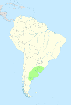 Approximate location and borders of the Pampas encompassing the southeastern area of South America bordering the Atlantic Ocean
|
| Coordinates:
35°S
62°W
/
35°S 62°W
/
-35; -62
|
| Countries
|  Argentina
 Brazil
 Uruguay
|
|---|
| Elevation
| 160 m (520 ft)
|
|---|
|
| ? Total
| 43,909,235
|
|---|
The
Pampas
(from the
Quechua
:
pampa
, meaning "plain") are fertile
South American
low
grasslands
that cover more than 1,200,000 square kilometres (460,000 sq mi) and include the
Argentine
provinces
of
Buenos Aires
,
La Pampa
,
Santa Fe
,
Entre Rios
, and
Cordoba
; all of
Uruguay
; and
Brazil
's southernmost
state
,
Rio Grande do Sul
. The vast plains are a
natural region
, interrupted only by the low Ventana and Tandil hills, near
Bahia Blanca
and
Tandil
(Argentina), with a height of 1,300 m (4,265 ft) and 500 m (1,640 ft), respectively.
The climate is temperate, with
precipitation
of 600 to 1,200 mm (23.6 to 47.2 in) that is more or less evenly distributed throughout the year, making the soils appropriate for
agriculture
. The area is also one of the distinct physiography provinces of the larger
Parana
?
Paraguay
plain division.
Topography
[
edit
]
This region has generally low elevations, whose highest levels generally do not exceed 600 metres (2,000 ft) in altitude. The coastal areas and most of the Buenos Aires Province are predominantly plain (with some
wetlands
) and the interior areas (mainly in the southern part of the Brazilian state of Rio Grande do Sul and Uruguay) have low ranges of hills (like
Serras de Sudeste
in Brazil and
Cuchilla Grande
in Uruguay). Low hills covered by grasslands are called
coxilhas
(
Portuguese pronunciation:
[ko??i??s]
) in Portuguese and
cuchillas
(
Spanish pronunciation:
[ku?t?i?as]
) in Spanish, and it is the most typical landscape of the countryside areas in the northern parts of the Pampas. The highest elevations of the Pampas region are found in the
Sierra de la Ventana mountains
, in the southern part of Buenos Aires Province, with 1,239 metres (4,065 ft) at the summit of
Cerro Tres Picos
.
 Taim Ecological Station
, in the southernmost of Rio Grande do Sul (near the
Atlantic Ocean
), Brazil, is an example of flat topography with wetlands.
Taim Ecological Station
, in the southernmost of Rio Grande do Sul (near the
Atlantic Ocean
), Brazil, is an example of flat topography with wetlands.
Climates
[
edit
]
The climate of the Pampas is generally temperate, gradually giving way to a more
humid subtropical climate
in the north (
Cfa
, according to the
Koppen climate classification
, with a
Cwa
tendency (drier winters) in the northwestern edge); a cold
semi-arid climate
(
BSk
) on the southern and western fringes (like
San Luis Province
, western La Pampa Province and southern Buenos Aires Province); and an
oceanic climate
(
Cfb
) in the southeastern part (in the localities of
Mar del Plata
,
Necochea
, Tandil and the Sierra de la Ventana mountains, Argentina). Summer temperatures are more uniform than winter temperatures, generally ranging from 28 to 33 °C (82 to 91 °F) during the day. However, most cities in the Pampas occasionally have high temperatures that push 38 °C (100 °F), as occurs when warm, dry, northerly winds blow from southern Brazil, northern Argentina or
Paraguay
. Autumn arrives gradually in March and peaks in April and May. In April, highs range from 20 to 25 °C (68 to 77 °F) and lows from 9 to 13 °C (48 to 55 °F). The first frosts arrive in mid-April in the south and late May or early June in the north.
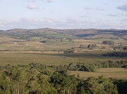 Coxilhas
(low hills covered by grasslands) in
Morro Redondo
, Rio Grande do Sul, Brazil
Coxilhas
(low hills covered by grasslands) in
Morro Redondo
, Rio Grande do Sul, Brazil
Winters are generally mild, but cold waves often occur. Typical temperatures range from 12 to 19 °C (54 to 66 °F) during the day, and from 1 to 6 °C (34 to 43 °F) at night. With strong northerly winds, days of over 25 °C (77 °F) can be recorded almost everywhere, and during cold waves, high temperatures can be only 6 °C (43 °F). Frost occurs everywhere in the Pampas, but it is much more frequent in the southwest than around the Parana and Uruguay Rivers. Temperatures under ?5 °C (23 °F) can occur everywhere, but values of ?10 °C (14 °F) or lower are confined to the south and west. Snow almost never falls in the northernmost third and is rare and light elsewhere, except for exceptional events in which depths have reached 30 cm (12 in). Springs are very variable; it is warmer than fall in most areas (especially in the west) but significantly colder along the Atlantic. Violent storms are more common as well as wide temperature variations: days of 35 °C (95 °F) can give way to nights of under 5 °C (41 °F) or even frost, all within only a few days.
Precipitation ranges from 1,400 millimetres (55 in) in the northeast to about 400 millimetres (16 in) or less in the southern and western edges. It is highly seasonal in the West, with some places recording averages of 120 millimetres (4.7 in) monthly in the summer, and only 20 millimetres (0.79 in) monthly in the winter. The eastern areas have small peaks in the fall and the spring, with relatively rainy summers and winters that are only slightly drier. However, where summer rain falls as short, heavy storms, winter rain falls mostly as cold drizzle, and so the amount of rainy days is fairly constant. Very intense
thunderstorms
are common in the spring and summer, and it has among the most frequent lightning and highest
convective
cloud tops in the world.
[1]
[2]
The severe thunderstorms produce intense
hailstorms
, both
floods
and
flash floods
, and the most consistently active
tornado
region outside the central and southeastern US.
[3]
Climate charts
[
edit
]
Climate charts for different locations of the Pampas:
| Bage
, Rio Grande do Sul, Brazil (1981-2010)
|
|---|
| Climate chart (
explanation
)
|
|---|
J
|
F
|
M
|
A
|
M
|
J
|
J
|
A
|
S
|
O
|
N
|
D
|
|
|
|
|
|
|
|
|
|
|
|
|
| ?
Average max. and min. temperatures in °C
|
| ?
Precipitation totals in mm
| | Source:
INMET
|
|
| Imperial conversion
|
|---|
| J
| F
| M
| A
| M
| J
| J
| A
| S
| O
| N
| D
|
|
|
|
|
|
|
|
|
|
|
|
|
| ?
Average max. and min. temperatures in °F
|
| ?
Precipitation totals in inches
|
|
| Santa Vitoria do Palmar
, Rio Grande do Sul, Brazil (1981-2010)
|
|---|
| Climate chart (
explanation
)
|
|---|
|
| Imperial conversion
|
|---|
| J
| F
| M
| A
| M
| J
| J
| A
| S
| O
| N
| D
|
|
|
|
|
|
|
|
|
|
|
|
|
| ?
Average max. and min. temperatures in °F
|
| ?
Precipitation totals in inches
|
|
| Buenos Aires
, Argentina (1981-2010)
|
|---|
| Climate chart (
explanation
)
|
|---|
|
| Imperial conversion
|
|---|
| J
| F
| M
| A
| M
| J
| J
| A
| S
| O
| N
| D
|
|
|
|
|
|
|
|
|
|
|
|
|
| ?
Average max. and min. temperatures in °F
|
| ?
Precipitation totals in inches
|
|
| Punta del Este
, Uruguay (1961-1990)
|
|---|
| Climate chart (
explanation
)
|
|---|
J
|
F
|
M
|
A
|
M
|
J
|
J
|
A
|
S
|
O
|
N
|
D
|
|
|
|
|
|
|
|
|
|
|
|
|
| ?
Average max. and min. temperatures in °C
|
| ?
Precipitation totals in mm
| | Source:
WMO
|
|
| Imperial conversion
|
|---|
| J
| F
| M
| A
| M
| J
| J
| A
| S
| O
| N
| D
|
|
|
|
|
|
|
|
|
|
|
|
|
| ?
Average max. and min. temperatures in °F
|
| ?
Precipitation totals in inches
|
|
| Viedma
, Argentina (1981-2010)
|
|---|
| Climate chart (
explanation
)
|
|---|
|
| Imperial conversion
|
|---|
| J
| F
| M
| A
| M
| J
| J
| A
| S
| O
| N
| D
|
|
|
|
|
|
|
|
|
|
|
|
|
| ?
Average max. and min. temperatures in °F
|
| ?
Precipitation totals in inches
|
|
| Coronel Suarez
, Buenos Aires, Argentina (1981-2010)
|
|---|
| Climate chart (
explanation
)
|
|---|
|
| Imperial conversion
|
|---|
| J
| F
| M
| A
| M
| J
| J
| A
| S
| O
| N
| D
|
|
|
|
|
|
|
|
|
|
|
|
|
| ?
Average max. and min. temperatures in °F
|
| ?
Precipitation totals in inches
|
|
| Laboulaye
, Cordoba, Argentina (1991-2020)
|
|---|
| Climate chart (
explanation
)
|
|---|
|
| Imperial conversion
|
|---|
| J
| F
| M
| A
| M
| J
| J
| A
| S
| O
| N
| D
|
|
|
|
|
|
|
|
|
|
|
|
|
| ?
Average max. and min. temperatures in °F
|
| ?
Precipitation totals in inches
|
|
Wildlife
[
edit
]
Human activity has caused major changes to the wildlife of the Pampas. Most big or medium-sized species such as
puma
,
rhea
,
Capybara
,
plains viscacha
,
maned wolf
,
[4]
marsh deer
and
Pampas deer
have
lost their habitats
especially due to the spread of agriculture and
ranching
, and are only present in very few relicts of the pampas.
[5]
Other species, such as the
Jaguar
and the
Guanaco
have been extirpated completely from this habitat.
Mammals that are still fairly present include
Brazilian guinea pig
,
southern mountain cavy
,
coypu
,
Pampas fox
,
Geoffroy's cat
,
lesser grison
,
white-eared opossum
,
Molina's hog-nosed skunk
,
big lutrine opossum
,
big hairy armadillo
and
southern long-nosed armadillo
. Bird species of the pampas are
ruddy-headed goose
,
pampas meadowlark
,
hudsonian godwit
,
maguari stork
,
white-faced ibis
,
white-winged coot
,
southern screamer
,
dot-winged crake
,
curve-billed reedhaunter
,
burrowing owl
[6]
and the rhea.
[7]
[8]
[9]
Invasive species include the
European hare
,
wild boar
and
house sparrow
.
-
Pampas deer
-
Pampas fox
-
Rhea
-
Southern screamer
-
Gilded hummingbird
Most of the large mammals native to the Pampas became extinct as part of the
Late Pleistocene megafauna extinctions
of most large mammals across the Americas around 12,000 years ago. Notable former inhabitants of the Pampas include the giant elephant-sized
ground sloth
Megatherium americanum
, along side the smaller (though still large) ground sloths
Mylodon
,
Glossotherium
Lestodon
and
Catonyx
, the rhinoceros like ungulate
Toxodon
, the camel-like
Macrauchenia
, the
gomphothere
(elephant-relative)
Notiomastodon
,
the equines
Equus neogeus
and
Hippidion
, and the
glyptodonts
(car-sized relatives of armadillos)
Glyptodon
and
Doedicurus
,
the bear
Arctotherium
and the sabre-tooth cat
Smilodon populator
.
[10]
Vegetation
[
edit
]
The dominant
vegetation
types are grassy
prairie
and grass
steppe
, in which numerous species of the grass genus
Stipa
are particularly conspicuous. "Pampas grass" (
Cortaderia selloana
) is an iconic species of the Pampas. Vegetation typically includes perennial
grasses
and
herbs
. Different strata of grasses occur because of gradients of water availability.
Why the pristine pampas were treeless regions has been much debated. Perhaps the most commonly cited explanation is seasonal drought. A related hypothesis is that grass roots compete for water and exclude tree seedlings. The effect might be increased by heavy, clayed soils which limit tap root penetration. Other causes that have been proposed are fires set by indigenous peoples for land clearance; the existence of heavy-bodied herbivores; and that the pampas are relicts of drier past climates. These explanations have been criticised as mono-causal. "Overall, we expect that low propagule pressure, abiotic stresses, biotic resistance, and a paucity of specific symbionts might have exerted a synergistic influence in slowing tree invasion rates ".
[11]
The
World Wildlife Fund
divides the Pampas into three distinct
ecoregions
. The
Uruguayan Savanna
lies east of the
Parana River
, and includes all of Uruguay, most of Entre Rios and
Corrientes
provinces in Argentina, and the southern portion of Brazil's state of Rio Grande do Sul. The
Humid Pampas
include eastern Buenos Aires Province, and southern Entre Rios Province. The
Semiarid Pampas
includes western Buenos Aires Province and adjacent portions of Santa Fe, Cordoba, and La Pampa provinces. The Pampas are bounded by the drier
Argentine Espinal
grasslands, which form a semicircle around the north, west, and south of the Humid Pampas.
Winters are cold to mild, and summers are hot and humid. Rainfall is fairly uniform throughout the year but is a little heavier during the summer. Annual rainfall is heaviest near the coast and decreases gradually further inland. Rain during the late spring and summer usually arrives in the form of brief heavy showers and thunderstorms. More general rainfall occurs the remainder of the year as
cold fronts
and storm systems move through. Although cold spells during the winter often send nighttime temperatures below freezing,
snow
is quite rare. In most winters, a few light snowfalls occur over inland areas.
Central Argentina boasts a successful agricultural business, with crops grown on the Pampas south and west of
Buenos Aires
. Much of the area is also used for
cattle
, and more recently, to cultivate vineyards in the
Buenos Aires wine region
. The area is also used for farming honey using European
honeybees
. These farming regions are particularly susceptible to
flooding
during thunderstorms. The weather averages out to be 16 °C (60 °F) year-round in the Pampas.
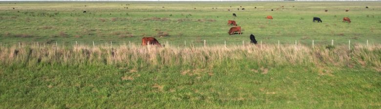 Pampas plains in Buenos Aires province, Argentina
Population
[
edit
]
-
Argentina
 Buenos Aires
17,196,396
Buenos Aires
17,196,396
 Cordoba
3,683,937
Cordoba
3,683,937
 Santa Fe
3,481,514
Santa Fe
3,481,514
 City of Buenos Aires
3,068,043
City of Buenos Aires
3,068,043
 Entre Rios
1,360,443
Entre Rios
1,360,443
 La Pampa
352,378
La Pampa
352,378
-
Brazil
-
Uruguay
- Total Population 43,909,235
Immigration
[
edit
]
Starting in the 1840s but intensifying after the 1880s, European immigrants began to migrate to the Pampas, first as part of government-sponsored colonization schemes to settle the land and later as tenant farmers "working as either a sharecropper or as paid laborers for absentee landowners"
[12]
in an attempt to make a living for themselves.
However, many immigrants eventually moved to more permanent employment in cities, as industrialization picked up after the 1930s. As a result, Argentina's history of immigration in Buenos Aires Province is typically associated with cities and urban life, unlike in Entre Rios Province and Santa Fe Province, where European immigration took on a more rural profile.
See also
[
edit
]
References
[
edit
]
- ^
Zipser, E. J.; C. Liu; D. J. Cecil; S. W. Nesbitt; D. P. Yorty (2006).
"Where are the Most Intense Thunderstorms on Earth?"
(PDF)
.
Bull. Am. Meteorol. Soc
.
87
(8): 1057?1071.
Bibcode
:
2006BAMS...87.1057Z
.
doi
:
10.1175/BAMS-87-8-1057
.
S2CID
51044775
. Archived from
the original
(PDF)
on 2020-08-06.
- ^
Virts, Katrina S.; J. M. Wallace; M. L. Hutchins; R. H. Holzworth (2013).
"Highlights of a New Ground-Based, Hourly Global Lightning Climatology"
.
Bull. Am. Meteorol. Soc
.
94
(9): 1381?91.
Bibcode
:
2013BAMS...94.1381V
.
doi
:
10.1175/BAMS-D-12-00082.1
.
S2CID
73647974
.
- ^
Rasmussen, Kristen L.; M. D. Zuluaga; R. A. Houze Jr. (2014).
"Severe convection and lightning in subtropical South America"
.
Geophys. Res. Lett
.
41
(20): 7359?66.
Bibcode
:
2014GeoRL..41.7359R
.
doi
:
10.1002/2014GL061767
.
- ^
Paula, R.C.; DeMatteo, K. (2016) [errata version of 2015 assessment].
"
Chrysocyon brachyurus
"
.
IUCN Red List of Threatened Species
.
2015
: e.T4819A88135664.
doi
:
10.2305/IUCN.UK.2015-4.RLTS.T4819A82316878.en
. Retrieved
27 March
2024
.
- ^
"Southern South America: Southeastern Argentina | Ecoregions | WWF"
.
World Wildlife Fund
. Retrieved
2020-02-20
.
- ^
BirdLife International. (2016).
"
Athene cunicularia
"
.
IUCN Red List of Threatened Species
.
2016
: e.T22689353A93227732.
doi
:
10.2305/IUCN.UK.2016-3.RLTS.T22689353A93227732.en
. Retrieved
27 March
2024
.
- ^
"Southern South America: Eastern Argentina"
.
World Wildlife Fund
.
- ^
Bernal, N. (2016).
"
Dolichotis salinicola
"
.
IUCN Red List of Threatened Species
.
2016
: e.T6786A22190451.
doi
:
10.2305/IUCN.UK.2016-2.RLTS.T6786A22190451.en
. Retrieved
27 March
2024
.
- ^
Black-Decima, P.A.; Vogliotti, A. (2016).
"
Mazama gouazoubira
"
.
IUCN Red List of Threatened Species
.
2016
: e.T29620A22154584.
doi
:
10.2305/IUCN.UK.2016-2.RLTS.T29620A22154584.en
. Retrieved
27 March
2024
.
- ^
Lopes, Renato Pereira; Pereira, Jamil Correa; Kerber, Leonardo; Dillenburg, Sergio Rebello (August 2020).
"The extinction of the Pleistocene megafauna in the Pampa of southern Brazil"
.
Quaternary Science Reviews
.
242
: 106428.
doi
:
10.1016/j.quascirev.2020.106428
.
- ^
Chaneton, Enrique J.; Mazia, Noemi; Batista, William B.; Rolhauser, Andres G.; Ghersa, Claudio M. (2012). "Woody Plant Invasions in Pampa Grasslands: A Biogeographical and Community Assembly Perspective". In Myster, Randall W. (ed.).
Ecotones Between Forest and Grassland
. Springer.
doi
:
10.1007/978-1-4614-3797-0_5
.
ISBN
978-1-4614-3797-0
. Retrieved
7 May
2024
.
, pp. 122-7.
- ^
Meade, Teresa A. (2016).
History of Modern Latin America: 1800 to the Present
. Wiley Blackwell Concise History of the Modern World. Wiley.
ISBN
978-1-118-77248-5
.
External links
[
edit
]