Street in Washington, D.C., United States
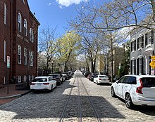 P Street NW in the
Georgetown
neighborhood in 2022
P Street NW in the
Georgetown
neighborhood in 2022
P Street
refers to four different streets within the city of
Washington, D.C.
The streets were named by President
George Washington
in 1791 as part of a general street naming program, in which east?west running streets were named alphabetically and north?south running streets numerically.
[1]
P Street NW runs westerly from
North Capitol Street
to the eastern boundary of
Georgetown University
(at 37th Street NW), with an additional block-long section running from the western edge of
Glover-Archbold Park
to Foxhall Road NW. P Street NW crosses
Rock Creek
and the
Rock Creek and Potomac Parkway
via the
P Street Bridge
. P Street NW also crosses
Dupont Circle
and
Logan Circle
. This P Street is the oldest of the four: the northern boundary of the City of Washington in the District of Columbia, as surveyed in July 1795, listed the P Street
ford
at Rock Creek as the starting point of the city's original northern boundary.
[2]
The first bridge to carry P Street over the creek was Paper Mill Bridge.
[2]
[3]
 The 2000 and 2100 blocks of P Street NW in 2012
P Street NW was important both commercially and topographically. The P Street ford marked the farthest point at which ocean-going ships could travel up Rock Creek.
[4]
Slash Run, a major tributary of Rock Creek, began at 1700 P Street.
[5]
P Street NW was also home to the city's earliest free African American residents. One of the first free blacks to buy property in the city was Lethe Hill, who purchased a lot at P and 30th Streets in 1819. Another free black, William Becraft, bought a home a block away.
[6]
In time, a large neighborhood of free blacks formed in a 10-block area bounded by P Street NW, Constitution Avenue NW, 16th Street NW, and 6th Street NW.
[7]
In the 1890s, Riggs Market?one of the city's important (if smaller) markets?was located on P Street NW between 14th and 15th Streets NW.
[8]
A church at 508 P Street NW, formerly the Zion Evangelical Lutheran Church, became Springfield Baptist Church in 1941.
Gospel
singer
Edna Gallmon Cooke
began her singing career there.
[9]
In 1885,
Major General
John A. Logan
purchased the "Stone Mansion" on Iowa Circle and P Street NW. Three-time presidential candidate
William J. Bryan
later leased it from the Logans.
[10]
Congress changed the circle's name to "Logan Circle" in December 1930 in Logan's honor.
[11]
The Dupont Circle Citizens Association was founded in 1922 in a townhouse at 1767 P Street.
[12]
P Street NE runs westerly for a single block from
North Capitol Street
to
Florida Avenue
NE. Areas further east are occupied by the
Amtrak
railroad tracks,
Union Market
,
Gallaudet University
,
Mount Olivet Cemetery
, the
United States National Arboretum
,
Anacostia Park
, and the
Anacostia River
. It does not extend into the
Deanwood
neighborhood.
 Looking east from the 300 block of P Street SW
P Street SW runs westerly from
South Capitol Street
to Southwest Waterfront Park, where it intersects with 4th Street SW. Along about half its length, on the south side of the street, is
Fort Lesley J. McNair
. The main entrance to the defense facility is on P Street SW. P Street SW lies within an area originally deeded to
Charles Carroll the Settler
in 1688, who sold it to Notley Young in 1770.
[13]
Around 1792, Young sold the property to developer
James Greenleaf
, who
platted
it in 1794. Greenleaf built large residential
townhomes
along P Street SW in 1794-1795, but sold the property shortly afterward. The area bordering P Street passed through several hands, with the property becoming more and more
fragmented
over time.
Benjamin G. Orr
, the fourth mayor of the city, owned property on P Street SW between 4 and 4-1/2 Streets. He later sold some of it to Reverend
Luther Rice
and some to
Secretary of the Treasury
William H. Crawford
. Two of the houses on this block of P Street were owned by
Columbia College
.
[14]
Navy Commodore
John Rodgers
purchased two of the homes on the far western end of P Street SW between 4th and 4-1/2 Streets SW, and connected the homes into a single dwelling. Rodgers' property extended to the Potomac River.
[15]
This block became known as "Rodgers Row".
[14]
In the early 1870s, the homes here were purchased and demolished by the
Metropolitan Railroad
to build its 4-1/2 Street Car Barn and Shop.
[16]
This streetcar barn was torn down in 1962 to allow for the construction of the Riverside Condominiums.
[17]
P Street SE is fragmented and truncated due to the topography of the eastern side of the
Anacostia River
. It runs westerly for two blocks between 18th Street NE and Naylor Road SE, and for about three blocks between
Pennsylvania Avenue
SE and Branch Avenue SE.
References
[
edit
]
- ^
Hagner, Alexander. "Street Nomenclature of Washington City."
Records of the Columbia Historical Society.
7 (1904), pp. 237-261, 240.
- ^
a
b
Hagner, Alexander. "Street Nomenclature of Washington City."
Records of the Columbia Historical Society.
7 (1904), pp. 237-261, 257.
- ^
Hawkins, Don Alexander. "The Landscape of the Federal City: A 1792 Walking Tour."
Washington History.
3:1 (Spring/Summer 1991), p. 10-33, 16.
- ^
Hawkins, Don Alexander. "The Landscape of the Federal City: A 1792 Walking Tour."
Washington History.
3:1 (Spring/Summer 1991), p. 10-33, 17.
- ^
The "run", or creek, got its name from "slashes", or stands, or
silver maples
which stood near its headwaters. See: Hawkins, Don Alexander. "The Landscape of the Federal City: A 1792 Walking Tour."
Washington History.
3:1 (Spring/Summer 1991), p. 10-33, 21.
- ^
Brown, Letitia. "Residence Patterns of Negroes in the District of Columbia, 1800-1860."
Records of the Columbia Historical Society.
69/70 (1969/1970), pp. 66-79, 74.
- ^
Half of all property in this area was owned by African Americans. See: Brown, Letitia. "Residence Patterns of Negroes in the District of Columbia, 1800-1860."
Records of the Columbia Historical Society.
69/70 (1969/1970), pp. 66-79, 76.
- ^
McArdle, Walter F. "The Development of the Business Sector in Washington, D. C., 1800-1973."
Records of the Columbia Historical Society.
49 (1973/1974), p. 556-594, 567.
- ^
Springfield Baptist Church,
Our History
, accessed 30 October 2020
- ^
Emery, Fred A. "Mount Pleasant and Meridian Hill."
Records of the Columbia Historical Society.
33/34 (1932), p. 187-223, 202.
- ^
Proctor, John Claggett. "Chronicler's Report for 1930."
Records of the Columbia Historical Society.
33/34 (1932), p. 352-356, 356.
- ^
Dupont Circle Citizens Association. No date.
Accessed 2012-10-20.
- ^
Henning, George C. "The Mansion and Family of Notley Young."
Records of the Columbia Historical Society.
16 (1913), p. 1-24, 4-5, 9-10.
- ^
a
b
Croggon, James. "Named Rodgers' Row."
The Evening Star.
March 30, 1907, p. 9.
- ^
Paullin, Charles O. "Washington City and the Old Navy."
Records of the Columbia Historical Society.
33/34 (1932), p. 163-177, 176.
- ^
"Streetcar and Bus Resources of Washington, D.C., 1862-1962." Multiple Property Documentation Form. National Register of Historic Places. National Park Service. United States Department of the Interior. May 10, 2006.
Accessed 2012-10-20.
- ^
Levey, Jane Freundel.
SW Heritage Trail Brochure.
Washington, D.C.: Cultural Tourism DC, 2004.
Archival URL.
Accessed 2012-10-20.
External links
[
edit
]
|
|---|
| History
| |
|---|
| Historic sites
| |
|---|
| Houses of worship
| |
|---|
| Streets and bridges
| |
|---|
| Education
| |
|---|
Parks and
cemeteries
| |
|---|
| Establishments
| |
|---|
|