Marginal sea of the Arctic or Atlantic Ocean, northwest of Norway
This article is about the actual sea. For the cruise ship, see
MS Norwegian Sea
. For the ancient name of the Kattegat, see
Kattegat
.
| Norwegian Sea
|
|---|
 The
Vestfjorden
with the mountains of the
Lofoten
archipelago seen from Løvøy Island in
Steigen
. Vagakaillen (942 m) is the taller of the two peaks in the centre of the image.
|
 The Norwegian Sea is outlined in red (
Europaisches Nordmeer
in German)
|
| Location
| Northern Europe
|
|---|
| Coordinates
| 69°N
2°E
/
69°N 2°E
/
69; 2
|
|---|
| Type
| Sea
|
|---|
| Primary inflows
| - Central North Atlantic,
- numerous Norwegian fjords
|
|---|
| Basin
countries
| Iceland
,
Norway
,
Denmark
(
Faroe Island
) and
United Kingdom
(
Shetland Island
)
|
|---|
|
| Surface area
| 1,383,000 km
2
(534,000 sq mi)
|
|---|
| Average depth
| 2,000 m (6,600 ft)
|
|---|
| Max. depth
| 3,970 m (13,020 ft)
|
|---|
| Water volume
| 2,000,000 km
3
(1.6
×
10
12
acre?ft)
|
|---|
|
| References
| [1]
[2]
[3]
|
|---|
The
Norwegian Sea
(
Norwegian
:
Norskehavet
;
Icelandic
:
Noregshaf
;
Faroese
:
Norskahavið
) is a
marginal sea
, grouped with either the
Atlantic Ocean
or the
Arctic Ocean
, northwest of
Norway
between the
North Sea
and the
Greenland Sea
, adjoining the
Barents Sea
to the northeast. In the southwest, it is separated from the Atlantic Ocean by a submarine ridge running between
Iceland
and the
Faroe Islands
. To the north, the
Jan Mayen
Ridge separates it from the Greenland Sea.
Unlike many other seas, most of the bottom of the Norwegian Sea is not part of a
continental shelf
and therefore lies at a great depth of about two kilometres on average. Rich deposits of oil and
natural gas
are found under the sea bottom and are being explored commercially, in the areas with sea depths of up to about one kilometre. The coastal zones are rich in fish that visit the Norwegian Sea from the North Atlantic or Barents Sea (cod) for
spawning
. The warm
North Atlantic Current
ensures relatively stable and high water temperatures, so that unlike the Arctic seas, the Norwegian Sea is ice-free throughout the year. Recent research has concluded that the large volume of water in the Norwegian Sea with its large heat absorption capacity is more important as a source of Norway's mild winters than the Gulf Stream and its extensions.
[4]
Extent
[
edit
]
The
International Hydrographic Organization
defines the limits of the Norwegian Sea as follows:
[5]
- On the Northeast.
A line joining the southernmost point of
West Spitzbergen
[
sic
] to North Cape of
Bear Island
, through this island to Cape Bull and thence on to
North Cape
in
Norway
(25°45'E).
- On the Southeast.
The West coast of Norway between North Cape and Cape Stadt (
62°10′N
5°00′E
/
62.167°N 5.000°E
/
62.167; 5.000
(
Cape Stadt
)
).
- On the South.
From a point on the West coast of Norway in
Latitude 61°00' North
along this parallel to Longitude 0°53' West thence a line to the NE extreme of
Fuglo
(
62°21′N
6°15′W
/
62.350°N 6.250°W
/
62.350; -6.250
(
Fuglo
)
) and on to the East extreme of Gerpir (
65°05′N
13°30′W
/
65.083°N 13.500°W
/
65.083; -13.500
(
Gerpir
)
) in
Iceland
.
- On the West.
The Southeastern limit of
Greenland Sea
[A line joining the southernmost point of West Spitzbergen [
sic
] to the Northern point of
Jan Mayen
Island, down the West coast of that island to its Southern extreme, thence a Line to the Eastern extreme of Gerpir (
65°05′N
13°30′W
/
65.083°N 13.500°W
/
65.083; -13.500
(
Gerpir
)
) in Iceland].
Formation and geography
[
edit
]
 Norwegian Sea, surrounded by shallower seas to the south (North Sea) and northeast (Barents Sea). The white dot near the centre is Jan Mayen, and the dot between Spitsbergen (large island to the north) and Norway is
Bear Island
.
Norwegian Sea, surrounded by shallower seas to the south (North Sea) and northeast (Barents Sea). The white dot near the centre is Jan Mayen, and the dot between Spitsbergen (large island to the north) and Norway is
Bear Island
.
 Vedøya, Skumvær and Røst islands,
Lofoten
, Norway
Vedøya, Skumvær and Røst islands,
Lofoten
, Norway
The Norwegian Sea was formed about 250 million years ago, when the
Eurasian plate
of Norway and the
North American Plate
, including Greenland, started to move apart. The existing narrow shelf sea between Norway and Greenland began to widen and deepen.
[6]
The present continental slope in the Norwegian Sea marks the border between Norway and Greenland as it stood approximately 250 million years ago. In the north it extends east from
Svalbard
and on the southwest between Britain and the Faroes. This continental slope contains rich fishing grounds and numerous
coral reefs
. Settling of the shelf after the separation of the continents has resulted in
landslides
, such as the
Storegga Slide
about 8,000 years ago that induced a major
tsunami
.
[6]
The coasts of the Norwegian Sea were shaped during the
last ice age
. Large
glaciers
several kilometres high pushed into the land, forming fjords, removing the crust into the sea, and thereby extending the continental slopes. This is particularly clear off the Norwegian coast along
Helgeland
and north to the
Lofoten Islands
.
[6]
The
Norwegian continental shelf
is between 40 and 200 kilometres wide, and has a different shape from the shelves in the North Sea and Barents Sea. It contains numerous trenches and irregular peaks, which usually have an amplitude of less than 100 metres, but can reach up to 400 metres.
[7]
They are covered with a mixture of gravel, sand, and mud, and the trenches are used by fish as spawning grounds.
[6]
Deeper into the sea, there are two deep basins separated by a low ridge (its deepest point at 3,000 m) between the
Vøring Plateau
and
Jan Mayen
island. The southern basin is larger and deeper, with large areas between 3,500 and 4,000 metres deep. The northern basin is shallower at 3,200?3,300 metres, but contains many individual sites going down to 3,500 metres.
[8]
Submarine thresholds and continental slopes mark the borders of these basins with the adjacent seas. To the south lies the European
continental shelf
and the North Sea, to the east is the Eurasian continental shelf with the Barents Sea. To the west, the
Scotland-Greenland Ridge
separates the Norwegian Sea from the North Atlantic. This ridge is on average only 500 metres deep, only in a few places reaching the depth of 850 metres. To the north lie the Jan Mayen Ridge and Mohns Ridge, which lie at a depth of 2,000 metres, with some trenches reaching depths of about 2,600 metres.
[8]
Hydrology
[
edit
]
 Tide ranges and tide times (
hours after Bergen
) along the Norwegian coast
Tide ranges and tide times (
hours after Bergen
) along the Norwegian coast
 Thermohaline circulation explains the formation of cold, dense deep water in the Norwegian Sea. The entire circulation pattern takes ~2000 years to complete.
 Surface currents in the North Atlantic
Four major water masses originating in the Atlantic and Arctic oceans meet in the Norwegian Sea, and the associated currents are of fundamental importance for the global climate. The warm, salty
North Atlantic Current
flows in from the Atlantic Ocean, and the colder and less saline
Norwegian Current
originates in the North Sea. The so-called East Iceland Current transports cold water south from the Norwegian Sea toward Iceland and then east, along the
Arctic Circle
; this current occurs in the middle water layer. Deep water flows into the Norwegian Sea from the Greenland Sea.
[8]
The tides in the sea are semi-diurnal; that is, they rise twice a day, to a height of about 3.3 metres.
[1]
Surface currents
[
edit
]
The hydrology of the upper water layers is largely determined by the flow from the North Atlantic. It reaches a speed of 10
Sv
(1 Sv = million m
3
/s) and its maximum depth is 700 metres at the Lofoten Islands, but normally it is within 500 metres.
[8]
Part of it comes through the Faroe-Shetland Channel and has a comparatively high
salinity
of 35.3‰ (parts per thousand). This current originates in the North Atlantic Current and passes along the European continental slope; increased evaporation due to the warm European climate results in the elevated salinity. Another part passes through the Greenland-Scotland trench between the Faroe Islands and
Iceland
; this water has a mean salinity between 35 and 35.2‰.
[9]
The flow shows strong seasonal variations and can be twice as high in winter as in summer.
[7]
While at the Faroe-Shetland Channel it has a temperature of about 9.5 °C; it cools to about 5 °C at Svalbard and releases this energy (about 250 terawatts) to the environment.
[10]
[8]
The current flowing from the
North Sea
originates in the Baltic Sea and thus collects most of the drainage from northern Europe; this contribution is however relatively small.
[7]
The temperature and salinity of this current show strong seasonal and annual fluctuations. Long-term measurements within the top 50 metres near the coast show a maximum temperature of 11.2 °C at the
63° N parallel
in September and a minimum of 3.9 °C at the North Cape in March. The salinity varies between 34.3 and 34.6‰ and is lowest in spring owing to the inflow of melted snow from rivers.
[8]
The largest rivers discharging into the sea are
Namsen
,
Ranelva
and
Vefsna
. They are all relatively short, but have a high discharge rate owing to their steep mountainous nature.
[11]
A portion of the warm surface water flows directly, within the
West Spitsbergen Current
, from the Atlantic Ocean, off the Greenland Sea, to the Arctic Ocean. This current has a speed of 3?5 Sv and has a large impact on the climate.
[12]
Other surface water (~1 Sv) flows along the Norwegian coast in the direction of the
Barents Sea
. This water may cool enough in the Norwegian Sea to submerge into the deeper layers; there it displaces water that flows back into the North Atlantic.
[13]
Arctic water from the East Iceland Current is mostly found in the southwestern part of the sea, near Greenland. Its properties also show significant annual fluctuations, with long-term average temperature being below 3 °C and salinity between 34.7 and 34.9‰.
[8]
The fraction of this water on the sea surface depends on the strength of the current, which in turn depends on the pressure difference between the
Icelandic Low
and
Azores High
: the larger the difference, the stronger the current.
[14]
Deep-sea currents
[
edit
]
The Norwegian Sea is connected with the Greenland Sea and the Arctic Ocean by the 2,600-metre deep
Fram Strait
.
[15]
The Norwegian Sea Deep Water (NSDW) occurs at depths exceeding 2,000 metres; this homogeneous layer with a salinity of 34.91‰ experiences little exchange with the adjacent seas. Its temperature is below 0 °C and drops to ?1 °C at the ocean floor.
[8]
Compared with the deep waters of the surrounding seas, NSDW has more nutrients but less oxygen and is relatively old.
[16]
The weak deep-water exchange with the Atlantic Ocean is due to the small depth of the relatively flat
Greenland-Scotland Ridge
between Scotland and Greenland, an offshoot of the
Mid-Atlantic Ridge
. Only four areas of the Greenland-Scotland Ridge are deeper than 500 metres: the
Faroe-Bank Channel
(about 850 metres), some parts of the
Iceland-Faroe Ridge
(about 600 metres), the
Wyville-Thomson Ridge
(620 metres), and areas between
Greenland
and the
Denmark Strait
(850 metres) ? this is much shallower than the Norwegian Sea.
[13]
[16]
Cold deep water flows into the Atlantic through various channels: about 1.9 Sv through the Faroe Bank channel, 1.1 Sv through the Iceland-Faroe channel, and 0.1 Sv via the Wyville-Thomson Ridge.
[17]
The turbulence that occurs when the deep water falls behind the Greenland-Scotland Ridge into the deep Atlantic basin mixes the adjacent water layers and forms the
North Atlantic Deep Water
, one of two major deep-sea currents providing the deep ocean with oxygen.
[18]
Climate
[
edit
]
The thermohaline circulation affects the climate in the Norwegian Sea, and the regional climate can significantly deviate from average. There is also a difference of about 10 °C between the sea and the coastline. Temperatures rose between 1920 and 1960,
[19]
and the frequency of storms decreased in this period. The storminess was relatively high between 1880 and 1910, decreased significantly in 1910?1960, and then recovered to the original level.
[11]
In contrast to the Greenland Sea and Arctic seas, the Norwegian Sea is ice-free year round, owing to its warm currents.
[1]
The convection between the relatively warm water and cold air in the winter plays an important role in the Arctic climate.
[20]
The 10-degree July isotherm (air temperature line) runs through the northern boundary of the Norwegian Sea and is often taken as the southern boundary of the Arctic.
[21]
In winter, the Norwegian Sea generally has the lowest air pressure in the entire Arctic and where most
Icelandic Low
depressions form. The water temperature in most parts of the sea is 2?7 °C in February and 8?12 °C in August.
[1]
 Phytoplankton
bloom in the Norwegian Sea.
Phytoplankton
bloom in the Norwegian Sea.
Flora and fauna
[
edit
]
The Norwegian Sea is a transition zone between
boreal
and Arctic conditions, and thus contains flora and fauna characteristic of both climatic regions.
[8]
The southern limit of many Arctic species runs through the North Cape, Iceland, and the center of the Norwegian Sea, while the northern limit of boreal species lies near the borders of the Greenland Sea with the Norwegian Sea and Barents Sea; that is, these areas overlap. Some species like the
scallop
Chlamys islandica
and
capelin
tend to occupy this area between the Atlantic and Arctic oceans.
[22]
Plankton and sea bottom organisms
[
edit
]
Most of the aquatic life in the Norwegian Sea is concentrated in the upper layers. Estimates for the entire North Atlantic are that only 2% of biomass is produced at depths below 1,000 metres and only 1.2% occurs near the sea floor.
[23]
The blooming of the
phytoplankton
is dominated by
chlorophyll
and peaks around 20 May. The major phytoplankton forms are
diatoms
, in particular the genus
Thalassiosira
and
Chaetoceros
. After the spring bloom the
haptophytes
of the genus
Phaecocystis pouchetti
become dominant.
[24]
Zooplankton is mostly represented by the
copepods
Calanus finmarchicus
and
Calanus hyperboreus
, where the former occurs about four times more often than the latter and is mostly found in the Atlantic streams, whereas
C. hyperboreus
dominates the Arctic waters;
[24]
they are the main diet of most marine predators.
[22]
The most important krill species are
Meganyctiphanes norvegica
,
Thyssanoessa inermis
, and
Thyssanoessa longicaudata
.
[24]
In contrast to the Greenland Sea, there is a significant presence of
calcareous
plankton (
Coccolithophore
and
Globigerinida
) in the Norwegian Sea.
[23]
Plankton production strongly fluctuates between years. For example,
C. finmarchicus
yield was 28 g/m
2
(dry weight) in 1995 and only 8 g/m
2
in 1997; this correspondingly affected the population of all its predators.
[24]
Shrimp of the species
Pandalus borealis
play an important role in the diet of fish, particularly cod and
blue whiting
, and mostly occur at depths between 200 and 300 metres. A special feature of the Norwegian Sea is extensive coral reefs of
Lophelia pertusa
, which provide shelter to various fish species. Although these corals are widespread in many peripheral areas of the North Atlantic, they never reach such amounts and concentrations as at the Norwegian continental slopes. However, they are at risk due to increasing
trawling
, which mechanically destroys the coral reefs.
[24]
Fish
[
edit
]
 Atlantic herring
The Norwegian coastal waters are the most important spawning ground of the
herring populations
of the North Atlantic, and the hatching occurs in March. The eggs float to the surface and are washed off the coast by the northward current. Whereas a small herring population remains in the fjords and along the northern Norwegian coast, the majority spends the summer in the Barents Sea, where it feeds on the rich plankton. Upon reaching puberty, herring returns to the Norwegian Sea.
[25]
The herring stock varies greatly between years. It increased in the 1920s owing to the milder climate and then collapsed in the following decades until 1970; the decrease was, however, at least partly caused by overfishing.
[19]
The biomass of young hatched herring declined from 11 million tonnes in 1956 to almost zero in 1970;
[22]
that affected the ecosystem not only of the Norwegian Sea but also of the Barents Sea.
[26]
 Capelin
is a common fish of the Atlantic-arctic transitional waters
Capelin
is a common fish of the Atlantic-arctic transitional waters
Enforcement of environmental and fishing regulations has resulted in partial recovery of the herring populations since 1987.
[19]
[22]
This recovery was accompanied by a decline of capelin and cod stocks. While the capelin benefited from the reduced fishing, the temperature rise in the 1980s and competition for food with the herring resulted in a near disappearance of young capelin from the Norwegian Sea.
[27]
Meanwhile, the elderly capelin population was quickly fished out. This also reduced the population of cod ? a major predator of capelin ? as the herring was still too small in numbers to replace the capelin in the cod's diet.
[27]
[28]
 Blue whiting
Blue whiting
(
Micromesistius poutassou
) has benefited from the decline of the herring and capelin stocks as it assumed the role of major predator of plankton. The blue whiting spawns near the British Isles. The sea currents carry their eggs to the Norwegian Sea, and the adults also swim there to benefit from the food supply. The young spend the summer and the winter until February in Norwegian coastal waters and then return to the warmer waters west of Scotland.
[8]
The Norwegian Arctic cod mostly occurs in the Barents Sea and at the
Svalbard
Archipelago. In the rest of the Norwegian Sea, it is found only during the reproduction season, at the Lofoten Islands,
[25]
whereas
Pollachius virens
and
haddock
spawn in the coastal waters.
[8]
Mackerel
is an important commercial fish. The coral reefs are populated by different species of the genus
Sebastes
.
[24]
Mammals and birds
[
edit
]
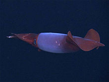 Armhook squid
Gonatus fabricii
Armhook squid
Gonatus fabricii
Significant numbers of
minke
,
humpback
,
sei
, and
orca
whales are present in the Norwegian Sea,
[29]
and
white-beaked dolphins
occur in the coastal waters.
[30]
Orcas and some other whales visit the sea in the summer months for feeding; their population is closely related to the herring stocks, and they follow the herring schools within the sea.
[24]
With a total population of about 110,000, minke whales are by far the most common whales in the sea. They are hunted by Norway and Iceland, with a quota of about 1,000 per year in Norway. In contrast to the past, nowadays primarily their meat is consumed, rather than fat and oil.
[31]
The
bowhead whale
used to be a major plankton predator, but it almost disappeared from the Norwegian Sea after intense whaling in the 19th century,
[22]
and was temporarily extinct in the entire North Atlantic. Similarly, the
blue whale
used to form large groups between Jan Mayen and Spitsbergen, but is hardly present nowadays.
[32]
Observations of
northern bottlenose whales
in the Norwegian Sea are rare.
[33]
Other large animals of the sea are
hooded
and
harp seals
and
squid
.
[22]
Important waterfowl species of the Norwegian Sea are
puffin
,
kittiwake
and
guillemot
. Puffins and guillemots also suffered from the collapse of the herring population, especially the puffins on the Lofoten Islands. The latter hardly had an alternative to herring and their population was approximately halved between 1969 and 1987.
[34]
Human activities
[
edit
]
Norway, Iceland, and Denmark/Faroe Islands share the territorial waters of the Norwegian Sea, with the largest part belonging to the first. Norway has claimed
twelve-mile limit
as territorial waters since 2004 and an exclusive economic zone of 200 miles since 1976. Consequently, due to the Norwegian islands of Svalbard and Jan Mayen, the southeast, northeast and northwest edge of the sea fall within Norway. The southwest border is shared between Iceland and Denmark/Faroe Islands.
[35]
According to the Føroyingasøga, Norse settlers arrived on the islands around the 8th Century. King Harald Fairhair is credited with being the driving force to colonize these islands as well as others in the Norwegian sea.
[36]
The largest damage to the Norwegian Sea was caused by extensive fishing, whaling, and pollution. Other contamination is mostly by oil and toxic substances,
[35]
but also from the great number of ships sunk during the two world wars.
[37]
The environmental protection of the Norwegian Sea is mainly regulated by the
OSPAR
Convention.
[35]
Fishing and whaling
[
edit
]
 Traditional
cod
stand
Traditional
cod
stand
 Arctic whaling (18th century). The ships are Dutch and the animals are
bowhead whales
.
Beerenberg
on Jan Mayen Land can be seen in the background.
Arctic whaling (18th century). The ships are Dutch and the animals are
bowhead whales
.
Beerenberg
on Jan Mayen Land can be seen in the background.
Fishing has been practised near the Lofoten archipelago for hundreds of years. The coastal waters of the remote Lofoten islands are one of the richest fishing areas in Europe, as most of the Atlantic cod swims to the coastal waters of Lofoten in the winter to spawn. So in the 19th century, dried cod was one of Norway's main exports and by far the most important industry in northern Norway. Strong sea currents,
maelstroms
, and especially frequent storms made fishing a dangerous occupation: several hundred men died on the "Fatal Monday" in March 1821, 300 of them from a single
parish
, and about a hundred boats with their crews were lost within a short time in April 1875.
[38]
Over the last century, the Norwegian Sea has been suffering from overfishing. In 2018, 41% of stocks were excessively harvested.
[39]
Two out of sixteen of the Total Allowed Catches (TACs) agreed upon by the
European Union
(EU) and Norway follow scientific advice. Nine of those TACs are at least 25% above scientific advice. While the other five are set above scientific evidence when excluding landing obligation.
[40]
Under the
Common Fisheries Policy
(CFP), the EU committed to phase out overfishing by 2015, 2020 at the absolute latest.
[41]
As of 2019, the EU was reported to not be on path to achieving that goal.
[42]
Whaling was also important for the Norwegian Sea. In the early 1600s, the Englishman
Stephen Bennet
started hunting
walrus
at
Bear Island
. In May 1607 the
Muscovy Company
, while looking for the
Northwest Passage
and exploring the sea, discovered the large populations of walrus and whales in the Norwegian Sea and started hunting them in 1610 near
Spitsbergen
.
[43]
Later in the 17th century, Dutch ships started hunting bowhead whales near
Jan Mayen
; the bowhead population between Svalbard and Jan Mayen was then about 25,000 individuals.
[44]
Britons and Dutch were then joined by Germans,
Danes
, and Norwegians.
[43]
Between 1615 and 1820, the waters between Jan Mayen, Svalbard, Bear Island, and Greenland, between the Norwegian, Greenland, and Barents Seas, were the most productive whaling area in the world. However, extensive hunting had wiped out the whales in that region by the early 20th century.
[32]
Sea monsters and maelstroms
[
edit
]
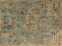 The
Carta Marina
(1539) by
Olaus Magnus
is the earliest detailed map of the Nordic countries. Note various sea monsters on the map.
The
Carta Marina
(1539) by
Olaus Magnus
is the earliest detailed map of the Nordic countries. Note various sea monsters on the map.
 Illustration by
Harry Clarke
(1889?1931) for
Edgar Allan Poe
's story "Descent into the Maelstrom," published in 1919.
Illustration by
Harry Clarke
(1889?1931) for
Edgar Allan Poe
's story "Descent into the Maelstrom," published in 1919.
For many centuries, the Norwegian Sea was regarded as the edge of the known world. The disappearance of ships there, due to the natural disasters, induced legends of monsters that stopped and sank ships (
kraken
). As late as in 1845, the
Encyclopædia metropolitana
contained a multi-page review by
Erik Pontoppidan
(1698?1764) on ship-sinking sea monsters half a mile in size.
[45]
Many legends might be based on the work
Historia de gentibus septentrionalibus
of 1539 by
Olaus Magnus
, which described the kraken and maelstroms of the Norwegian Sea.
[46]
The kraken also appears in
Alfred Tennyson
's poem of the same name, in Herman Melville's
Moby Dick
, and in
Twenty Thousand Leagues Under the Sea
by
Jules Verne
.
Between the
Lofoten islands
of
Moskenesøya
and
Værøy
, at the tiny
Mosken
island, lies the
Moskenstraumen
? a system of
tidal
eddies
and a
whirlpool
called a maelstrom. With a speed on the order of 15 km/h (9 mph) (the value strongly varies between sources), it is one of the strongest maelstroms in the world. It was described in the 13th century in the
Old Norse
Poetic Edda
and remained an attractive subject for painters and writers, including
Edgar Allan Poe
,
Walter Moers
and
Jules Verne
. The word was introduced into the English language by Poe in his story "
A Descent into the Maelstrom
" (1841) describing the Moskenstraumen.
[47]
The Moskenstraumen is created as a result of a combination of several factors, including the tides, the position of the Lofoten, and the underwater topography; unlike most other whirlpools, it is located in the open sea rather than in a channel or bay. With a diameter of 40?50 metres, it can be dangerous even in modern times to small fishing vessels that might be attracted by the abundant cod feeding on the microorganisms sucked in by the whirlpool.
[48]
Exploration
[
edit
]
 In the late 19th century,
Henrik Mohn
developed the first dynamic flow model of the North Atlantic. This map of 1904 shows surface and underwater currents.
In the late 19th century,
Henrik Mohn
developed the first dynamic flow model of the North Atlantic. This map of 1904 shows surface and underwater currents.
The fish-rich coastal waters of northern Norway have long been known and attracted skilled sailors from Iceland and Greenland. Thus most settlements in Iceland and Greenland were on the west coasts of the islands, which were also warmer due to the Atlantic currents. The first reasonably reliable map of northern Europe, the
Carta marina
of 1539, represents the Norwegian Sea as coastal waters and shows nothing north of the North Cape. The Norwegian Sea off the coast regions appeared on the maps in the 17th century as an important part of the then sought
Northern Sea Route
and a rich whaling ground.
[49]
Jan Mayen island was discovered in 1607 and become an important base of Dutch whalers. The Dutchman
Willem Barents
discovered
Bear Island
and
Svalbard
,
[49]
which was then used by Russian whalers called
pomors
. The islands on the edge of the Norwegian Sea have been rapidly divided between nations. During the peaks of whaling, some 300 ships with 12,000 crew members were yearly visiting Svalbard.
[49]
The first
depth measurements
of the Norwegian Sea were performed in 1773 by
Constantine Phipps
aboard HMS
Racehorse
, as a part of his North Pole expedition.
[50]
Systematic
oceanographic research
in the Norwegian Sea started in the late 19th century, when declines in the yields of cod and herring off the Lofoten prompted the Norwegian government to investigate the matter.
[51]
The zoologist
Georg Ossian Sars
and meteorologist
Henrik Mohn
persuaded the government in 1874 to send out a scientific expedition, and between 1876 and 1878 they explored much of the sea aboard
Vøringen
.
[52]
The data obtained allowed Mohn to establish the first dynamic model of ocean currents, which incorporated winds, pressure differences, sea water temperature, and salinity and agreed well with later measurements.
[53]
In 2019, deposits of iron, copper, zink and cobalt were found on the Mohn Ridge, likely from
hydrothermal vents
.
[54]
Navigation
[
edit
]
 HMS
Sheffield
during the winter convoy through the Norwegian Sea to Russia in 1941
HMS
Sheffield
during the winter convoy through the Norwegian Sea to Russia in 1941
 Soviet nuclear submarine
K-278 Komsomolets
, 1986
Soviet nuclear submarine
K-278 Komsomolets
, 1986
Until the 20th century, the coasts of the Norwegian Sea were sparsely populated and therefore shipping in the sea was mostly focused on fishing, whaling, and occasional coastal transportation. Since the late 19th century, the
Norwegian Coastal Express
sea line has been established, connecting the more densely populated south with the north of Norway by at least one trip a day. The importance of shipping in the Norwegian Sea also increased with the expansion of the Russian and Soviet navies in the Barents Sea and development of international routes to the Atlantic through the
Baltic Sea
,
Kattegat
,
Skagerrak
, and
North Sea
.
The Norwegian Sea is ice-free and provides a direct route from the Atlantic to the Russian ports in the Arctic (
Murmansk
,
Arkhangelsk
, and
Kandalaksha
), which are directly linked to central Russia. This route was extensively used for supplies during World War II ? of 811 US ships, 720 reached Russian ports, bringing some 4 million tonnes of cargo that included about 5,000 tanks and 7,000 aircraft. The Allies lost 18 convoys and 89 merchant ships on this route.
[55]
The major operations of the German Navy against the convoys included
PQ 17
in July 1942, the
Battle of the Barents Sea
in December 1942, and the
Battle of the North Cape
in December 1943 and were carried out around the border between the Norwegian Sea and Barents Sea, near the North Cape.
[55]
Navigation across the Norwegian Sea declined after World War II and intensified only in the 1960s?70s with the expansion of the
Soviet Northern Fleet
, which was reflected in major joint naval exercises of the Soviet Northern Baltic fleets in the Norwegian Sea. The sea was the gateway for the Soviet Navy to the Atlantic Ocean and thus to the United States, and the major Soviet port of
Murmansk
was just behind the border of the Norwegian and Barents Sea.
[56]
The countermeasures by the NATO countries resulted in a significant naval presence in the Norwegian Sea and intense cat-and-mouse games between Soviet and NATO aircraft, ships, and especially submarines.
[57]
A relic of the Cold War in the Norwegian Sea, the Soviet nuclear submarine
K-278 Komsomolets
, sank in 1989 southwest of Bear Island, at the border of the Norwegian and Barents seas, with radioactive material onboard that poses potential danger to flora and fauna.
[58]
The Norwegian Sea is part of the
Northern Sea Route
for ships from European ports to Asia. The travel distance from
Rotterdam
to
Tokyo
is 21,100 km (13,111 mi) via the
Suez Canal
and only 14,100 km (8,761 mi) through the Norwegian Sea. Sea ice is a common problem in the Arctic seas, but ice-free conditions along the entire northern route were observed at the end of August 2008.
[59]
Russia is planning to expand its offshore oil production in the Arctic, which should increase the traffic of tankers through the Norwegian Sea to markets in Europe and America; it is expected that the number of oil shipments through the northern Norwegian Sea will increase from 166 in 2002 to 615 in 2015.
[60]
 Map of the
Langeled pipeline
Map of the
Langeled pipeline
Oil and gas
[
edit
]
The most important products of the Norwegian Sea are no longer fish, but oil and especially gas found under the ocean floor.
[61]
Norway started undersea oil production in 1993, followed by development of the Huldra gas field in 2001.
[62]
The large depth and harsh waters of the Norwegian Sea pose significant technical challenges for offshore drilling.
[63]
Whereas drilling at depths exceeding 500 metres has been conducted since 1995, only a few deep gas fields have been explored commercially. The most important current project is
Ormen Lange
(depth 800?1,100 m), where gas production started in 2007. With reserves of 4.0
×
10
11
m
3
(1.4
×
10
13
cu ft), it is the major Norwegian gas field. It is connected to the
Langeled
pipeline, currently the world's longest underwater pipeline, and thus to a major European gas pipeline network.
[64]
[65]
Several other gas fields are being developed. As of 2019, there is an estimated 6.5 hm
3
of crude oil in the Norwegian Sea, with an expectation to increase oil production in the region up until 2025. A particular challenge is the Kristin field, where the temperature is as high as 170 °C and the gas pressure exceeds 900 bar (900 times the normal pressure).
[63]
Further north are
Norne
and
Snøhvit
.
In popular culture
[
edit
]
In the fishing simulation game
Russian Fishing 4
, Norwegian Sea is a popular map especially for
boat fishing
.
[66]
See also
[
edit
]
References
[
edit
]
- ^
a
b
c
d
Norwegian Sea
,
Great Soviet Encyclopedia
(in Russian)
- ^
Norwegian Sea
, Encyclopædia Britannica on-line
- ^
ICES, 2007
, p. 1
- ^
Westerly storms warm Norway
Archived
2018-09-29 at the
Wayback Machine
. The Research Council of Norway. Forskningsradet.no (3 September 2012). Retrieved on 2013-03-21.
- ^
"Limits of Oceans and Seas, 3rd edition"
(PDF)
. International Hydrographic Organization. 1953. Archived from
the original
(PDF)
on 8 October 2011
. Retrieved
28 December
2020
.
- ^
a
b
c
d
Terje Thornes & Oddvar Longva "The origin of the coastal zone" in:
Sætre, 2007
, pp. 35?43
- ^
a
b
c
Sætre, 2007
, pp. 44?58
- ^
a
b
c
d
e
f
g
h
i
j
k
Blindheim, 1989
, pp. 366?382
- ^
Aken, 2007
, pp. 119?124
- ^
Roald Sætre
Driving forces
in:
Sætre, 2007
, pp. 44?58
- ^
a
b
Matti Seppala
The Physical Geography of Fennoscandia
, Oxford University Press, 2005
ISBN
0-19-924590-8
, pp. 121?141
- ^
Tyler, 2003
, pp. 45?49
- ^
a
b
Tyler, 2003
, pp. 115?116
- ^
ICES, 2007
, pp. 2?4
- ^
Tyler, 2003
, pp. 240?260
- ^
a
b
Aken, 2007
, pp. 131?138
- ^
Skreslet & NATO, 2005
, p. 93
- ^
Ronald E. Hester, Roy M. Harrison
Biodiversity Under Threat
, Royal Society of Chemistry, 2007
ISBN
0-85404-251-2
, p. 96
- ^
a
b
c
Gerold Wefer, Frank Lamy, Fauzi Mantoura
Marine Science Frontiers for Europe
, Springer, 2003
ISBN
3-540-40168-7
, pp. 32?35
- ^
Schaefer, 2001
, pp. 10?17
- ^
Kieran Mulvaney
At the Ends of the Earth: A History of the Polar Regions
, Iceland Press, 2001
ISBN
1-55963-908-3
, p. 23
- ^
a
b
c
d
e
f
Skreslet & NATO, 2005
, pp. 103?114
- ^
a
b
Andrea Schroder-Ritzrau
et al.
,
Distribution, export and alteration of plankton in the Norwegian Sea Fossiliziable
.
Schaefer, 2001
, pp. 81?104
- ^
a
b
c
d
e
f
g
ICES, 2007
, pp. 5?8
- ^
a
b
Blindheim, 1989
, pp. 382?401
- ^
Olav Schram Stokke
Governing High Seas Fisheries: The Interplay of Global and Regional regime,
Oxford University Press, 2001
ISBN
0-19-829949-4
, pp. 241?255
- ^
a
b
Gene S. Helfman
Fish Conservation: A Guide to Understanding and Restoring Global Aquatic Biodiversity and Fishery Resources
, Iceland Press, 2007
ISBN
1-55963-595-9
, pp. 321?323
- ^
National Research Council (U.S.). Committee on Ecosystem Management for Sustainable Marine Fisheries: Sustaining Marine Fisheries, National Academies Press, 1999,
ISBN
0-309-05526-1
, p. 46
- ^
Erich Hoyt:
Marine Protected Areas for Whales, Dolphins, and Porpoises
Earthscan, 2005
ISBN
1-84407-063-8
, pp. 120?128
- ^
Klinowska, 1991
, p. 138
- ^
Norwegian minke whaling
. the Norwegian Ministry of Foreign Affairs. norway.org.uk
- ^
a
b
Johnson, 1982
, pp. 95?101
- ^
Klinowska, 1991
, p. 320
- ^
Simon Jennings
et al.
Marine Fisheries Ecology
, Blackwell Publishing, 2001
ISBN
0-632-05098-5
, p. 297
- ^
a
b
c
Alf Hakon Noel
The Performance of Exclusive Economic Zones ? The Case of Norway
in: Syma A. Ebbin et al.
A Sea Change: The Exclusive Economic Zone and Governance Institutions for Living Marine Resources
, Springer, 2005
ISBN
1-4020-3132-7
- ^
"Archaeology of Viking Age Faroe Islands ? Projekt Forl?g"
(in Czech). 2 June 2016
. Retrieved
2020-12-09
.
- ^
Tyler, 2003
, p. 434
- ^
Tim Denis Smith
Scaling Fisheries: The Science of Measuring the Effects of Fishing, 1855?1955
, Cambridge University Press, 1994
ISBN
0-521-39032-X
, pp. 10?15
- ^
"EU still far from phasing out overfishing by 2020"
.
Oceana Europe
. Retrieved
2020-12-07
.
- ^
"EU-Norway agreement the worst outcome for fish stocks in ten years"
.
Our Fish
. Retrieved
2020-12-07
.
- ^
"Depleted fish stocks can't wait. The EU and Norway need to commit to ending overfishing now ? View"
.
euronews
. 2019-12-02
. Retrieved
2020-12-07
.
- ^
Elliott, Stuart (24 January 2023).
"Norway plans to include more Barents Sea, Norwegian Sea blocks in new APA round"
.
www.spglobal.com
. Retrieved
16 February
2023
.
- ^
a
b
Richards, 2006
, pp. 589?596
- ^
Richards, 2006
, pp. 574?580
- ^
Octopus
in:. E. Smedley et al. (Eds):
Encyclopædia metropolitana; or, universal dictionary of knowledge
in 1845, pp. 326?330
- ^
Terry Glavin
The Sixth Extinction: Journeys Among the Lost and Left Behind
, Macmillan, 2007
ISBN
0-312-36231-5
, p. 149
- ^
The Merriam-Webster new book of word histories
, 1991,
ISBN
0-87779-603-3
p. 300
- ^
Tom Kopel
Ebb and Flow: Tides and Life on Our Once and Future Planet
, Dundurn Press, 2007
ISBN
1-55002-726-3
, pp. 76?79
- ^
a
b
c
Neil Kent
The Soul of the North: A Social, Architectural and Cultural History of the Nordic Countries, 1700?1940
, Reaktion Books, 2001
ISBN
1-86189-067-2
, pp. 300?302
- ^
Colin Summerhayes, "The exploration of the sea floor" in Margaret Deacon et al. (Eds)
Understanding the oceans: a century of ocean exploration
, Routledge, 2001
ISBN
1-85728-705-3
, p. 93
- ^
Mills, 2001
, pp. 41?43
- ^
Mills, 2001
, pp. 44?47
- ^
Mills, 2001
, pp. 50?53
- ^
Andersen, Ina (14 June 2019).
"Minaleralfunnet pa havbunnen inneholder mye kobber"
.
Tu.no
(in Norwegian).
Teknisk Ukeblad
.
- ^
a
b
Edward L. Killham:
The Nordic Way: A Path to Baltic Equilibrium
, Howells House, 1993
ISBN
0-929590-12-0
, p. 106
- ^
Joel J. Sokolsky
Seapower in the Nuclear Age: The United States Navy and NATO, 1949?80
Taylor & Francis, 1991
ISBN
0-415-00806-9
, pp. 83?87
- ^
Olav Riste.
NATO's Northern Front Line in 1980s
in: Olav Njølstad:
The Last Decade of the Cold War: From Conflict Escalation to Conflict Transformation
, Routledge, 2004
ISBN
0-7146-8539-9
, pp. 360?371
- ^
Hugh D. Livingston:
Marine Radioactivity
Elsevier, 2004
ISBN
0-08-043714-1
, p. 92
- ^
Seidler, Christoph (August 27, 2008).
"Northeast ? and the Northwest Passage ice-free for the first time at the same time"
.
Der Spiegel
. Retrieved
July 21,
2011
.
- ^
Leichenko, Robin M. & Karen L. O'Brien:
Environmental Change and Globalization
ISBN
0-19-517732-0
, p. 99
- ^
Jerome D. Davis.
Changing World of Oil: An Analysis of Corporate Change and Adaptation
Ashgate Publishing, 2006
ISBN
0-7546-4178-3
, p. 139
- ^
Ann Genova
The Politics of the Global Oil Industry
, Greenwood Publishing Group, 2005
ISBN
0-275-98400-1
, pp. 202?209
- ^
a
b
Geo ExPro November 2004.
Kristin ? A Tough Lady
Archived
2011-07-11 at the
Wayback Machine
(pdf)
- ^
Country Analysis Briefs: Norway
, Energy Information Administration
- ^
Moskwa, Wojciech (September 13, 2007).
"Norway's Ormen Lange gas starts flowing to Britain"
.
Reuters
. Retrieved
March 30,
2022
.
- ^
"Russian Fishing 4 - Norwegian Sea Trailer - News"
.
Russian Fishing 4
. Retrieved
16 February
2023
.
Bibliography
[
edit
]
- van Aken, Hendrik Mattheus (2007).
The Oceanic Thermohaline Circulation: An Introduction
.
Springer
.
ISBN
978-0-387-36637-1
.
- Blindheim, Johan (1989).
"Ecological Features of the Norwegian Sea"
. In Louis Rene Rey; et al. (eds.).
Proceedings of the Sixth Conference of the Comite arctique international, 13?15 May 1985
.
Brill Publishers
. pp. 366?401.
ISBN
90-04-08281-6
.
- International Council for the Exploration of the Sea
(2007).
The Barents Sea and the Norwegian Sea
(PDF)
. ICES Advice 2007. Vol. 3. Archived from the original on 2011-09-27.
{{
cite book
}}
: CS1 maint: bot: original URL status unknown (
link
)
- Johnson, Arne Odd (1982).
The History of Modern Whaling
. C. Hurst & Co. Publishers.
ISBN
0-905838-23-8
.
- Klinowska, Margaret, ed. (1991).
Dolphins, Porpoises and Whales of the World: The IUCN Red Data Book
.
ISBN
2-88032-936-1
.
- Mills, Eric L. (2001).
"Mathematics in Neptune's Garden"
. In Helen M. Rozwadowski & David K. van Keuren (ed.).
The Machine in Neptune's Garden: Historical Perspectives on Technology and the Marine Environment
. Science History Publications/USA.
ISBN
0-88135-372-8
.
- Richards, John F. (2006).
The Unending Frontier: An Environmental History of the Early Modern World
.
University of California Press
.
ISBN
0-520-24678-0
.
- Sætre, Roald, ed. (2007).
The Norwegian Coastal Current ? Oceanography and Climate
. Trondheim:
Tapir Academic Press
.
ISBN
978-82-519-2184-8
.
- Schaefer, Priska (2001).
The Northern North Atlantic: A Changing Environment
.
Springer
.
ISBN
3-540-67231-1
.
- Skreslet, Stig;
North Atlantic Treaty Organization
(2005).
Jan Mayen Iceland in Scientific Focus
.
Springer
.
ISBN
1-4020-2956-X
.
- Tyler, Paul A. (2003).
Ecosystems of the Deep Oceans: Ecosystems of the World
.
Elsevier
.
ISBN
0-444-82619-X
.
External links
[
edit
]
|
|---|
| International
| |
|---|
| National
| |
|---|
| Other
| |
|---|
|
|---|
| Basins
| |
|---|
| Bays
| |
|---|
| Channels
| |
|---|
| Gulfs
| |
|---|
| Seas
| |
|---|
|