Overview of the geography of Wales
Wales
is a
country
that is
part of
the
United Kingdom
and whose
physical geography
is characterised by a varied
coastline
and a largely
upland
interior. It is
bordered
by
England
to its east, the
Irish Sea
to its north and west, and the
Bristol Channel
to its south. It has a total area of 2,064,100 hectares (5,101,000 acres) and is about 170 mi (274 km) from north to south and at least 60 mi (97 km) wide. It comprises 8.35 percent of the land of the United Kingdom. It has a number of offshore islands, by far the largest of which is
Anglesey
. The mainland coastline, including Anglesey, is about 1,680 mi (2,704 km) in length. As of 2014, Wales had a population of about 3,092,000;
Cardiff
is the capital and largest city and is situated in the urbanised area of
South East Wales
.
Wales has a complex geological history which has left it a largely mountainous country. The coastal plain is narrow in the north and west of the country but wider in the south, where the
Vale of Glamorgan
has some of the best agricultural land. Exploitation of the
South Wales Coalfield
during the
Industrial Revolution
resulted in the development of an urban economy in the South Wales Valleys, and the expansion of the port cities of
Newport
, Cardiff and
Swansea
for the export of
coal
. The smaller
North Wales Coalfield
was also developed at this time, but elsewhere in the country, the landscape is rural and communities are small, the economy being largely dependent on agriculture and tourism. The climate is influenced by the proximity of the country to the
Atlantic Ocean
and the prevailing westerly winds; thus it tends to be mild, cloudy, wet and windy.
Physical geography
[
edit
]
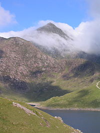 The summit of
Snowdon
, the highest
mountain
in Wales
The summit of
Snowdon
, the highest
mountain
in Wales
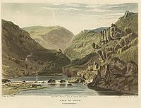 Depiction of the Vale of Towy, Carmarthenshire
Wales is located on the western side of central southern
Great Britain
. To the north and west is the
Irish Sea
, and to the south is the
Bristol Channel
. The English counties of
Cheshire
,
Shropshire
,
Herefordshire
and
Gloucestershire
lie to the east.
[3]
Much of the border with England roughly follows the line of the ancient earthwork known as
Offa's Dyke
.
[4]
The large island of
Anglesey
lies off the northwest coast, separated from mainland Wales by the
Menai Strait
, and there are a number of smaller islands.
[3]
Most of Wales is mountainous.
Snowdonia
(
Welsh
:
Eryri
) in the northwest has the highest mountains, with
Snowdon
(
Yr Wyddfa
) at 1,085 m (3,560 ft) being the highest peak. To the south of the main range lie the
Arenig Group
,
Cadair Idris
and the
Berwyn Mountains
. In the northeast of Wales, between the
Clwyd Valley
and the Dee Estuary, lies the
Clwydian Range
.
[3]
The 14 (or possibly 15) peaks over 3,000 feet (914 m), all in Snowdonia, are known collectively as the
Welsh 3000s
.
[5]
The
Cambrian Mountains
run from northeast to southwest and occupy most of the central part of the country. These are more rounded and undulating, clad in moorland and rough,
tussocky grassland
. In the south of the country are the
Brecon Beacons
in central Powys, the
Black Mountains
(
Y Mynyddoedd Duon
) spread across parts of Powys and Monmouthshire in southeast Wales and, confusingly,
Black Mountain
(
Y Mynydd Du
), which lies further west on the border between Carmarthenshire and Powys.
[3]
The Welsh lowland zone consists of the north coastal plain, the island of Anglesey, part of the
Ll?n Peninsula
, a narrow strip of coast along
Cardigan Bay
, much of
Pembrokeshire
and southern
Carmarthenshire
, the
Gower Peninsula
and the
Vale of Glamorgan
.
[3]
The main rivers are the
River Dee
, part of which forms the boundary between Wales and England, the River Clwyd and the
River Conwy
, which all flow northwards into
Liverpool Bay
and the Irish Sea. Further round the coast, the
Rivers Mawddach
,
Dovey
,
Rheidol
,
Ystwyth
and
Teifi
flow westwards into Cardigan Bay, and the rivers
Towy
,
Taff
,
Usk
and
Wye
flow southwards into the Bristol Channel. Parts of the
River Severn
form the boundary between Wales and England.
[3]
The length of the coast of mainland Wales is about 1,370 mi (2,205 km), and adding to this the coasts of the Isle of Anglesey and
Holy Island
, the total is about 1,680 mi (2,704 km).
[6]
Cardigan Bay is the largest bay in the country and
Bala Lake
(Llyn Tegid) the largest lake
[7]
at 4.7 km
2
(1.8 sq mi). Other large lakes include
Llyn Trawsfynydd
at 1.8 sq mi (4.7 km
2
),
[8]
Lake Vyrnwy
at 1.7 sq mi (4.4 km
2
),
[9]
Llyn Brenig
at 1.4 sq mi (3.6 km
2
),
[10]
Llyn Celyn
at 1.2 sq mi (3.1 km
2
)
[11]
and
Llyn Alaw
at 1.2 sq mi (3.1 km
2
).
[12]
Bala Lake lies in a
glacial valley
blocked by a
terminal moraine
, but the other lakes are
reservoirs
created by impounding rivers, to provide drinking water, hydroelectric schemes or flood defences, and many are also used recreationally.
[13]
Geology
[
edit
]
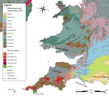 Geologic map of Wales
The geology of Wales is complex and varied. The earliest
outcropping
rocks are from the
Precambrian
era, some 700
Mya
, and are found in Anglesey, the Ll?n peninsula, southwestern Pembrokeshire and in places near the English border. During the
Lower Palaeozoic
, as seas periodically flooded the land and retreated again, thousands of metres of
sedimentary
and
volcanic rocks
accumulated in a marine
basin
known as the
Welsh Basin
.
[14]
Rocks found in a quarry near to the village
Llangynog
, Carmarthenshire, in 1977 contain some of the Earth's oldest fossils which date from the
Ediacaran
period, 564 million years ago, when Wales was part of the micro-continent
Avalonia
.
[15]
During the early and middle
Ordovician
period (485 to 460 Mya), volcanic activity increased. One large volcanic system, which was centred around what is now Snowdon, emitted an estimated 60 cubic kilometres (14 cu mi) of debris. Another volcano formed
Rhobell Fawr
near Dolgellau. During this period, great accumulations of sand, gravel and mud were deposited further south in Wales, and these gradually consolidated. Some of the volcanic ash fell in the sea and formed great banks, where unstable masses sometimes slid into deeper water, creating submarine
avalanches
. This caused great
turbidity
in the sea, after which the particles began to settle out according to particle size. The
strata
thus formed are called
turbidites
, and these are common in central Wales, being particularly obvious in the sea cliffs around
Aberystwyth
.
[14]
By the beginning of the
Devonian
period (420 Mya) the sea was retreating from the Welsh Basin as the land was thrust up by the collision of land masses, forming a new range of mountains, the Welsh Caledonides. The Old Red Sandstone represents debris from their erosion. Elsewhere the strata were compressed and deformed, and in places, the clay minerals recrystallised, developing a grain that allowed parallel cleavage, making it easy to split the rocks into thin flat sheets of stone known as
slate
. In the early part of the
Carboniferous
period, reinvasion of southern and northern parts of Wales by the sea resulted in depositions of limestone, and extensive swamps in South Wales gave rise to peat deposits and the eventual formation of coal measures. Erosion of nearby upland areas resulted in the formation of sandstones and mudstones in the later part of the period. Southwestern Wales, in particular, was affected by the
Variscan orogeny
, a period when continental collisions further south caused complex
folding
and fracturing of the strata.
[14]
During the
Permian
,
Triassic
and
Jurassic
(300 to 150 Mya), further episodes of
desertification
, subsidence and uplift occurred and Wales was alternately inundated by the sea and raised above it. By the
Cretaceous
(140 to 70 Mya), Wales was permanently above sea level and in the
Pleistocene
(2.5 Mya to recent), it underwent several exceptionally cold periods, the
ice ages
. The mountains we see today largely assumed their present shape during the last ice age, the
Devensian glaciation
.
[14]
In the mid 19th century, two prominent
geologists
,
Roderick Murchison
and
Adam Sedgwick
, used their studies of the
geology of Wales
to establish certain principles of
stratigraphy
and
palaeontology
. From the Latin name for Wales,
Cambria
(derived from
Cymru
), was derived the name of the earliest
geological
period of the Paleozoic era, the
Cambrian
. After much dispute, the next two periods of the Paleozoic era, the
Ordovician
and
Silurian
, were named after pre-Roman Celtic tribes of Wales, the
Ordovices
and
Silures
.
[16]
Climate
[
edit
]
Wales has a
maritime climate
, the predominant winds being southwesterlies and westerlies blowing in from the
Atlantic Ocean
. This means that the weather in Wales is in general mild, cloudy, wet and windy. The country's wide geographic variations cause localised differences in amounts of sunshine, rainfall and temperature. Rainfall in Wales varies widely, with the highest average annual totals in Snowdonia and the Brecon Beacons, and the lowest near the coast and in the east, close to the English border. Throughout Wales, the winter months are significantly wetter than the summer ones. Snow is comparatively rare near sea level in Wales, but much more frequent over the hills, and the uplands experience harsher conditions in winter than the more low-lying parts.
[17]
The mean annual temperatures in Wales are about 11 °C (52 °F) on the coast and 9.5 °C (49 °F) in low-lying inland areas. It becomes cooler at higher altitudes, with a mean decrease in annual temperatures of approximately 0.5 °C (0.9 °F) for each 100 metres (330 feet) of increased altitude. Consequently, the higher parts of Snowdonia experience mean annual temperatures of 5 °C (41 °F).
[17]
At nights, the coldest conditions occur when there is little wind and no cloud cover, especially when the ground is snow-clad; the lowest temperature recorded in Wales was in conditions of this sort at
Rhayader
on New Year's Day, 1940, when the temperature fell to ?23.3 °C (?9.9 °F). Occasionally, the coastal area of North Wales experiences some of the warmest winter conditions in the United Kingdom, with temperatures up to 18 °C (64 °F); these result from a
Foehn wind
, a south-westerly airflow warming up as it descends from the mountains of Snowdonia.
[17]
 Rain coming in from the west in
Snowdonia
Rain coming in from the west in
Snowdonia
Rainfall in Wales is mostly as a result of the arrival of Atlantic
low pressure systems
and is heaviest between October and January over the whole country. The driest months are usually April, May and June, and Wales experiences fewer summer thunderstorms than England. Rainfall varies across the country with the highest records being from the greatest elevations. Snowdonia experiences total annual rainfalls exceeding 3,000 mm (118 in) whereas coastal regions of Wales and the English border may have less than 1,000 mm (39 in). The combination of mountainous areas and Atlantic lows can produce large quantities of rain and sometimes results in flooding.
[17]
The amount of snowfall varies with altitude and enormously from year to year. In the lowlands, the number of days with lying snow may vary from zero to thirty or more, with an average of about twenty in Snowdonia.
[17]
Wales is one of the windier parts of the United Kingdom. The strongest winds are usually associated with Atlantic depressions; as one of these arrives, the winds usually start in the southwest, before veering to the west and then to the northwest as the system passes by. The southwest of Pembrokeshire experiences the most gale-force winds. The highest wind speed ever recorded in Wales at a lowland site was gusts of 108 knots (200 km/h; 124 mph) at
Rhoose
, in the Vale of Glamorgan, on 28 October 1989.
[17]
Land use
[
edit
]
 Hill farm with
Welsh Black cattle
Hill farm with
Welsh Black cattle
The total terrestrial surface
[
clarification needed
]
of Wales is 2,064,100 hectares (5,101,000 acres). The
area of land used for agriculture and forestry
in the country in 2013 was 1,712,845 hectares (4,232,530 acres). Of this 79,461 hectares (196,350 acres) was used for arable cropping and fallow, 1,449 hectares (3,580 acres) for horticulture, and 1,405,156 hectares (3,472,220 acres) was used for grazing. Woodland occupied 63,366 hectares (156,580 acres) and 10,126 hectares (25,020 acres) was unclassified land. In addition, there were 180,305 hectares (445,540 acres) of common rough grazing, giving a total area of all the land used for agriculture purposes, including common land, of 1,739,863 hectares (4,299,300 acres).
[18]
In order of area planted, the arable crops grown in Wales were: foods for stock-feeding, spring barley, wheat, maize, winter barley, other cereals for combining, oilseed rape, potatoes and other crops. The grassland was predominantly permanent pasture, with only 10% of the grassland being under five years old.
[18]
Compared with other parts of the United Kingdom, Wales has the smallest percentage of arable land (6%), and a considerably smaller area of rough grazing and hill land than Scotland (27% against 62%).
[19]
Natural resources
[
edit
]
Vast quantities of coal were mined in Wales during the
Industrial Revolution
and the earlier part of the twentieth century, after which coal stocks dwindled and the remaining pits became uneconomical as foreign coal became available at low prices. The last deep pit in Wales closed in 2008.
[20]
Ironstone
outcrops along the northern edge of the South Wales Coalfield were extensively worked for the production of iron and were important in the initiation of the Industrial Revolution in South Wales.
[21]
Lead
,
silver
and to a lesser extent
zinc
were mined in the upland areas of the rivers
Ystwyth
and
Rheidol
and in the headwaters of the
River Severn
for centuries and smaller deposits were also mined at
Pentre Halkyn
in Flintshire during the Roman occupation of Britain.
Copper
was a major export from
Parys Mountain
on
Anglesey
which was, at its height, the largest copper mine in the world.
 Penrhyn Quarry
in about 1900
Penrhyn Quarry
in about 1900
Slate quarrying has been a major industry in North Wales. The
Cilgwyn Quarry
was being worked in the 12th century, but later
Blaenau Ffestiniog
became the centre of production.
[22]
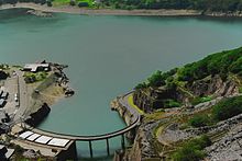 The
Dinorwig Power Station
lower reservoir, a 1,800 MW pumped-storage hydroelectric scheme, one of the largest such schemes in Europe
[23]
The
Dinorwig Power Station
lower reservoir, a 1,800 MW pumped-storage hydroelectric scheme, one of the largest such schemes in Europe
[23]
With its mountainous terrain and ample rainfall, water is one of Wales' most abundant resources. The country has many man-made
reservoirs
and exports water to England as well as generating power through
hydroelectric schemes
.
Wind is another resource that Wales has in abundance.
Gwynt y Mor
is one of several
offshore wind farms
off the coast of the North Wales mainland and Anglesey, and is the second largest such wind farm in the world.
[24]
Political geography
[
edit
]
Border between Wales and England
[
edit
]
The modern
border between Wales and England
was largely defined by the
Laws in Wales Acts 1535 and 1542
, based on the boundaries of
medieval
Marcher lordships
. According to the Welsh historian
John Davies
:
[25]
Thus was created the border between Wales and England, a border which has survived until today. It did not follow the old line of Offa's Dyke nor the eastern boundary of the Welsh dioceses; it excluded districts such as Oswestry and Ewias, where the Welsh language would continue to be spoken for centuries, districts which it would not be wholly fanciful to consider as
Cambria irredenta
. Yet, as the purpose of the statute was to incorporate Wales into England, the location of the Welsh border was irrelevant to the purposes of its framers.
The boundary has never been confirmed by referendum or reviewed by a
Boundary Commission
. The boundary line very roughly follows Offa's Dyke from south to north as far as a point about 40 miles (64 km) from the northern coast, but then swings further east.
[26]
It has a number of anomalies, but some were ironed out by the
Counties (Detached Parts) Act 1844
.
[27]
For instance, it separates
Knighton
from its railway station,
[28]
and divides the village of
Llanymynech
where a pub straddles the line.
[29]
Local government
[
edit
]
Wales is divided into 22
unitary authorities
, which are responsible for the provision of all local government services, including education, social work, environmental and road services. Below these in some areas there are
community councils
, which cover specific areas within a council area. The unitary authority areas are known as "
principal areas
".
[30]
The King appoints
Lords Lieutenant
to represent him in the eight
preserved counties of Wales
.
[31]
In the
Office for National Statistics
Area Classification, local authorities are clustered into groups based in the six main
census
dimensions (demographic, household composition, housing, socio-economic, employment and industry sector). Most of the local authorities in mid and west Wales are classified as part of the 'Coastal and Countryside' supergroup. Most of the south Wales authorities,
Flintshire
and
Wrexham
are in the 'Mining and Manufacturing' supergroup;
Cardiff
is part of the 'Cities and Services' supergroup and the Vale of Glamorgan is part of 'Prospering UK'.
[32]
Social geography
[
edit
]
A number of historians of
Wales
have questioned the notion of a single, cohesive Welsh identity. For example, in 1921,
Alfred Zimmern
, the inaugural professor of international relations at the
University of Wales, Aberystwyth
, argued that there was "not one Wales, but three": archetypal 'Welsh Wales', industrial or 'American Wales', and upper-class 'English Wales'. Each represented different parts of the country and different traditions.
[33]
In 1985, political analyst Dennis Balsom proposed a similar 'Three Wales model'. Balsom's regions were the Welsh-speaking heartland of the north and west,
Y Fro Gymraeg
; a consciously Welsh but not Welsh-speaking 'Welsh Wales' in the
South Wales Valleys
and a more ambivalent 'British Wales' making up the remainder, largely in the east and along the south coast.
[34]
The division reflects, broadly, the areas where
Plaid Cymru
,
Labour
, and the
Conservatives
and
Liberal Democrats
respectively enjoyed the most political support.
[
citation needed
]
Topography
has traditionally limited the integration between North and South Wales, with the two halves virtually functioning as separate economic and social units in the preindustrial era, with successive British Government transport policy doing little to rectify it.
[35]
Today, the main road and rail links run east-west, although there was once a north-south rail link that pressure groups are attempting to reinstate.
[36]
By the interwar years, industry in South Wales was increasingly linked to
Avonside
and the
English Midlands
, and that in north Wales to
Merseyside
.
[37]
Liverpool was often called "the capital of north Wales" in the late 19th and early 20th century. With 20,000 Welsh-born people living on either side of the Mersey in 1901, the city had an array of Welsh chapels and cultural institutions; hosted the
National Eisteddfod
in 1884, 1900 and 1929 and gave rise to several leading figures in Welsh life in the 20th century.
[38]
The
Liverpool Daily Post
became, effectively, the daily newspaper for north Wales.
[39]
The decline of Liverpool after the Second World War and changing patterns of Welsh migration, caused the Welsh presence to diminish. In the 1960s, the flooding of the
Tryweryn Valley
to provide the city with water soured relations with many people in Wales.
[38]
The North Welsh are sometimes referred to, in
Wenglish
, as
Gogs
(from the Welsh
gogledd
, "north") and the south Welsh as
Hwntws
(from
tu hwnt
roughly meaning 'far away over there' or 'beyond'). There are differences in the Welsh vocabulary between the north and south; for instance, the south Welsh word for
now
is
nawr
whereas the north Welsh is
r?an
.
[
citation needed
]
The more urbanised south, containing cities such as
Cardiff
,
Newport
and
Swansea
, was historically home to the coal and steel industries. It contrasts with the mostly rural north, where agriculture and slate quarrying were the main industries. Although the
M4 corridor
brings wealth into South Wales, particularly Cardiff, there is no pronounced
economic divide between north and south
unlike in England; there is, for example, a high level of poverty in the postindustrial
South Wales Valleys
.
[
citation needed
]
Demography
[
edit
]
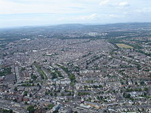 Cardiff
is the most densely populated area in Wales
Cardiff
is the most densely populated area in Wales
The estimated population of Wales in 2019 was about 3,152,879, an increase of 14,248 on the previous year.
[40]
The main population and industrial areas in Wales are in
South Wales
, specifically Cardiff,
Swansea
and
Newport
and the adjoining
South Wales Valleys
. Cardiff is the capital city and had a population of around 346,000 at the 2011 census. This was followed by the unitary authorities of Swansea (239,000), Rhondda Cynon Taf (234,400), Carmarthenshire (183,800), Caerphilly (178,800), Flintshire (152,500), Newport (145,700), Neath Port Talbot (139,800), Bridgend (139,200) and Wrexham (134,800).
[41]
Cardiff was the most heavily populated area in Wales with 2,482 people per square kilometre (6,428 per sq mile) while Powys had just 26.
[42]
A high proportion of the Welsh population lives in smaller settlements: nearly 20% live in villages of less than 1,500 persons compared with 10% in England. Wales also has a relatively low proportion of its population in large settlements: only 26% live in urban areas with a population over 100,000; in comparison, nearly 40% of the English population live in urban areas larger than the largest in Wales. Another feature of the settlement pattern in Wales is the share of the population living in the sparsest rural areas: 15% compared with only 1.5% in England.
[43]
Communications
[
edit
]
Communications within Wales are influenced by the topography and the mountainous nature of the country: the main rail and road routes between South and North Wales loop to the east and pass largely through England. The only motorway corridor in Wales is the
M4 motorway
from London to South Wales, entering the country over the
Second Severn Crossing
, passing close to Newport, Cardiff and Swansea and extending as far west as the
Pont Abraham services
before continuing northwest as the
A48
to
Carmarthen
. The
M48 motorway
parallels the M4 between
Aust
and
Magor
via
Chepstow
. The
A40
is a major
trunk road
connecting London to
Fishguard
via
Brecon
and Carmarthen.
[44]
The
A487
coast road links Cardigan with Aberystwyth, and the
A44
links Aberystwyth with Rhayader,
Leominster
and
Worcester
.
[45]
The main trunk road in North Wales is the
A55
dual carriageway
road from Chester past
St Asaph
and
Abergele
, continuing along the coast to
Bangor
, crossing Anglesey and terminating at
Holyhead
.
[46]
The
A483
runs from Swansea to Chester passing
Llandovery
,
Llandrindod Wells
,
Oswestry
(in England) and
Wrexham
.
 The
A55
running alongside the
North Wales Coast Line
The
A55
running alongside the
North Wales Coast Line
The
South Wales Main Line
links
London Paddington
with Swansea, entering Wales through the
Severn Tunnel
. Other main line services from the Midlands and the North of England join this at Newport. Branch lines serve the South Wales Valleys, Barry, and destinations beyond Swansea which include the ferry terminals at Fishguard and Pembroke Dock. The
Heart of Wales Line
links
Llanelli
with
Craven Arms
in Shropshire.
[47]
The
Cambrian Line
crosses the centre of Wales, with trains from
Shrewsbury
to
Welshpool
, Aberystwyth and
Pwllheli
.
[48]
The
North Wales Coast Line
links
Crewe
and
Chester
to
Bangor
and
Holyhead
, from where there is a ferry service to Ireland. Passengers can change at
Shotton
for the
Borderlands Line
, which links Wrexham with
Bidston
on the
Wirral Peninsula
, and at Conwy for the
Conwy Valley Line
to
Blaenau Festiniog
.
[49]
The
Shrewsbury?Chester line
between Chester and Shrewsbury in England, passes through Wrexham, Chirk and Ruabon in Wales.
Cardiff Airport
is the only airport in Wales which offers international scheduled flights. Destinations available include other parts of the United Kingdom, Ireland and parts of continental Europe. The airport is also used for charter flights on a seasonal basis. In 2018, around 1.6 million passengers used the airport.
[50]
Several ferry services operate between Welsh ports and Ireland: Holyhead to
Dublin
; Fishguard to Rosslare;
[51]
Pembroke Dock to Rosslare;
[52]
and Swansea to
Cork
.
[53]
Protected areas
[
edit
]
 The
Pembrokeshire Coast Path
near
Ceibwr Bay
The
Pembrokeshire Coast Path
near
Ceibwr Bay
Wales has three designated
national parks
. Snowdonia National Park in northwestern Wales was established in 1951 as the third
national park in Britain
, following the
Peak District
and the
Lake District
. It covers 827 square miles (2,140 km
2
) of the mountains of Snowdonia and has 37 miles (60 km) of coastline.
[54]
[55]
The
Pembrokeshire Coast National Park
was established the following year to protect the spectacular coastal scenery of West Wales. It includes
Caldey Island
, the
Daugleddau
estuary and the
Preseli Hills
, as well as the entire length of the
Pembrokeshire Coast Path
.
[56]
The
Brecon Beacons National Park
was established five years later and extends across the southern part of Powys, the northwestern part of Monmouthshire, parts of eastern Carmarthenshire and the northern parts of several South Wales Valleys county boroughs. In each case, the national park authority acts as a
special purpose local authority
and exercises planning control over residential and industrial development in the park. The authorities have a duty to conserve the natural beauty of the area, and to promote opportunities for members of the public to enjoy and appreciate the park's special qualities.
[57]
Wales also has five
Areas of Outstanding Natural Beauty
. These differ from National Parks in that the local authorities have a duty to conserve and enhance the natural beauty of the landscape but do not have an obligation to promote the enjoyment of the public. Partnerships established to administer AONBs do not have control over planning, responsibility for which remains with the constituent local authorities.
[58]
In 1956, the Gower Peninsula became the first designated AONB in Britain.
[59]
Other AONBs are: the coast of Anglesey; the Ll?n Peninsula;
[60]
the
Clwydian Range and Dee Valley
;
[61]
and the
Wye Valley
, part of which is in England.
[62]
Wales has many waterfalls, including some of the most striking in the United Kingdom. One such is the 240 ft (73 m)
Pistyll Rhaeadr
near the village of
Llanrhaeadr-ym-Mochnant
. It is formed as a mountain stream drops over a cliff and changes character to a lowland river, the
Afon Rhaeadr
. The site was designated by the
Countryside Council for Wales
as the 1000th
Site of Special Scientific Interest
in Wales, because of its importance to an understanding of Welsh
geomorphology
. The 19th-century
English author
George Borrow
remarked of the waterfall, "I never saw water falling so gracefully, so much like thin, beautiful threads, as here."
[63]
See also
[
edit
]
Wales
[
edit
]
Other
[
edit
]
References
[
edit
]
- ^
"Standard Area Measurements for Administrative Areas (December 2023) in the UK"
.
Open Geography Portal
. Office for National Statistics. 31 May 2024
. Retrieved
7 June
2024
.
- ^
"A Beginners Guide to UK Geography (2023)"
.
Open Geography Portal
. Office for National Statistics. 24 August 2023
. Retrieved
9 December
2023
.
- ^
a
b
c
d
e
f
Philip's (1994).
Atlas of the World
. Reed International. pp. 16?17.
ISBN
0-540-05831-9
.
- ^
Else, David; Bardwell, Sandra; Dixon, Belinda; Dragicevich, Peter (2007).
Walking in Britain
. Lonely Planet. p. 333.
ISBN
978-1-74104-202-3
.
- ^
"The Welsh 3000s Challenge"
. The Welsh 3000s
. Retrieved
13 April
2016
.
- ^
"How long is the UK coastline?"
.
Cartopics
. The British Cartographic Society. Archived from
the original
on 22 May 2012
. Retrieved
25 April
2016
.
- ^
"Bala Lake"
. The Snowdonia National Park
. Retrieved
12 April
2016
.
- ^
"History"
.
Traws Lake
. Retrieved
12 April
2016
.
- ^
"Lake Vyrnwy"
.
1891 The Practical Engineer
. Technical Publishing Company
. Retrieved
12 April
2016
.
- ^
"Llyn Brenig Reservoir and Visitor Centre"
. AboutBritain.com
. Retrieved
12 April
2016
.
- ^
"Llyn Celyn"
. The Snowdonia National Park
. Retrieved
12 April
2016
.
- ^
"Llyn Alaw"
. Anglesey Visitor
. Retrieved
12 April
2016
.
- ^
Patmore, John Allan (1971).
Land and Leisure in England & Wales
. Fairleigh Dickinson Univ Press. p. 262.
ISBN
978-0-8386-1024-4
.
- ^
a
b
c
d
"Environmental Change and Mineral Formation in Wales"
.
Wales Underground
. Retrieved
13 April
2016
.
- ^
Thomas, Gavin (21 January 2024).
"Earth's earliest creatures dated from Welsh rocks"
.
BBC News
. Archived from
the original
on 21 January 2024
. Retrieved
21 January
2024
.
- ^
Jones, Alyn.
"What's in a name? Celtic Connections"
.
The Edinburgh Geologist: Issue No. 35
. Edinburgh Geological Society
. Retrieved
24 April
2016
.
- ^
a
b
c
d
e
f
"Wales: Climate"
. Met Office
. Retrieved
22 April
2016
.
- ^
a
b
"Land use"
. Climate Change Commission for Wales. p. 59
. Retrieved
22 April
2016
.
- ^
"A review of the Beef Sector in Wales"
. Meat Promotion Wales. 27 November 2014. Archived from
the original
on 15 April 2016
. Retrieved
22 April
2016
.
- ^
"Coal mine closes with celebration"
.
BBC News
. 25 January 2008
. Retrieved
22 April
2016
.
- ^
"Blaenavon World Heritage Site"
. Retrieved
23 April
2016
.
- ^
Lindsay, Jean (1974).
A History of the North Wales Slate Industry
. David and Charles. p. 314.
ISBN
0-7153-6264-X
.
- ^
"Dinorwig Power Station"
. Mitsui & Co., Ltd. Archived from
the original
on 12 May 2016
. Retrieved
23 April
2016
.
- ^
Denholm-Hall, Rupert (18 June 2015).
"World's second largest offshore wind farm opens off coast of Wales"
.
Wales Onlone
. Retrieved
23 April
2016
.
- ^
Davies, John (1993).
A History of Wales
. Penguin.
ISBN
0-14-028475-3
.
- ^
"The coming of the Tudors and the Act of Union (part 2)"
.
Guide to Welsh History
. BBC
. Retrieved
23 April
2016
.
- ^
"Counties (Detached Parts) Act 1844"
.
National Archives
. UK Government
. Retrieved
23 April
2016
.
- ^
"Knighton Railway Station"
. Show me Mid Wales
. Retrieved
23 April
2016
.
- ^
"Llanymynech location"
. The Church of England. Archived from
the original
on 6 May 2016
. Retrieved
23 April
2016
.
- ^
"Local Government (Wales) Act 1994"
.
The National Archives
. legislation,gov.uk
. Retrieved
22 April
2016
.
- ^
"Clwyd: County history"
. High Sheriff's Association of England and Wales. 2010. Archived from
the original
on 5 May 2016
. Retrieved
21 April
2016
.
- ^
"NS 2001 Area Classification for Local Authorities"
. Archived from
the original
on 9 June 2009
. Retrieved
20 December
2009
.
- ^
Williams, Chris
(Winter 2003?2004).
"A post national Wales"
(PDF)
.
Agenda
. Institute of Welsh Affairs. pp. 2?5.
Archived
(PDF)
from the original on 4 September 2017
. Retrieved
3 September
2017
.
- ^
Osmond, John (2002). "Welsh Civil Identity in the Twenty-First Century". In David C. Harvey; Rhys Jones; Neil McInroy; Christine Milligan (eds.).
Celtic Geographies: Old culture, new times
. London: Routledge. pp.
80
?82.
ISBN
0-415-22396-2
.
- ^
Malcolm Falkus; John Gillingham, eds. (1987).
Historical Atlas of Britain
. Kingfisher. p. 112.
ISBN
0-86272-295-0
.
- ^
"The Wales Transport Strategy"
(PDF)
. Welsh Assembly Government. 2008. Archived from
the original
(PDF)
on 14 December 2008
. Retrieved
18 March
2010
.
- ^
Morgan, Kenneth O.
(1982).
Rebirth of a nation: Wales 1880-1980
. Oxford University Press. p.
245
.
ISBN
0-19-821760-9
.
- ^
a
b
John Davies; Nigel Jenkins; Menna Baines; Peredur I. Lynch (2008).
The Welsh Academy Encyclopedia of Wales
. Cardiff: University of Wales Press. p. 469.
ISBN
978-0-7083-1953-6
.
- ^
Morgan, Kenneth O. (1982).
Rebirth of a nation: Wales 1880-1980
. Oxford University Press. pp.
6?7
.
ISBN
0-19-821760-9
.
- ^
"National level population estimates by year, age and UK country"
.
statswales.gov.wales
. Retrieved
7 August
2020
.
- ^
"Population change, 2001-2011"
.
2011 Census: Population and Household Estimates for Wales, March 2011
. Office for National Statistics
. Retrieved
24 April
2016
.
- ^
Blake, Aled (8 August 2013).
"UK population soars - but Wales still home to regions of emptiness"
.
Wales Online
. Retrieved
23 April
2016
.
- ^
Welsh Assembly Government (2005).
Rural Development Plan for Wales, 2007 to 2013: The Strategic Approach
. Welsh Assembly Government. pp. 61?63.
ISBN
0-7504-9757-2
.
- ^
Concise Road Atlas: Britain
. AA Publishing. 2015. pp. 24?27.
ISBN
978-0-7495-7743-8
.
- ^
Concise Road Atlas: Britain
. AA Publishing. 2015. pp. 36?39.
ISBN
978-0-7495-7743-8
.
- ^
Concise Road Atlas: Britain
. AA Publishing. 2015. pp. 47?55.
ISBN
978-0-7495-7743-8
.
- ^
Williams, Sally (29 March 2013).
"Heart of Wales railway line in danger"
.
Wales Online
. Retrieved
23 April
2016
.
- ^
Jenkins, Stanley C.; Loader, Martin (2015).
The Great Western Railway: Shrewsbury to Pwllheli Vol. 5
. Amberley Publishing Limited. pp. 15?16.
ISBN
978-1-4456-4299-4
.
- ^
"Crewe to Holyhead"
. North Wales Coast Railway. 2012
. Retrieved
23 April
2016
.
- ^
seneddresearch (5 March 2020).
"Cardiff Airport ? How many people are checking in?"
.
IN BRIEF
. Retrieved
7 August
2020
.
- ^
"Ferries to Ireland"
. Stena Line
. Retrieved
23 April
2016
.
- ^
"Pembroke / Rosslare"
. Irish Ferries
. Retrieved
23 April
2016
.
- ^
"Cork to Swansea Ferry"
. Cork Ferries
. Retrieved
23 April
2016
.
- ^
Culliford, Alison (24 July 1999).
"National Parks: The complete guide to Britain's national parks"
.
The Independent
.
- ^
"Our national parks"
.
MSN
. Archived from
the original
on 2 October 2011.
- ^
"Pembrokeshire Coast National Park"
. Pembrokeshire Coast National Park Authority
. Retrieved
23 April
2016
.
- ^
"About us"
. National Parks. Archived from
the original
on 16 April 2016
. Retrieved
23 April
2016
.
- ^
"Natural England's statutory duties and powers"
. Natural England
. Retrieved
23 April
2016
.
- ^
"Gower Area of Outstanding Natural Beauty"
. City and County of Swansea
. Retrieved
23 April
2016
.
- ^
"Ll?n Area of Outstanding Natural Beauty"
. Gwynedd County Council
. Retrieved
23 April
2016
.
- ^
"Clwydian Range and Dee Valley Area of Outstanding Natural Beauty"
. Denbighshire Countryside Services
. Retrieved
23 April
2016
.
- ^
"Wye Valley Area of Outstanding Natural Beauty"
. Joint Advisory Committee
. Retrieved
23 April
2016
.
- ^
"Waterfall, 1000th on protected list"
.
BBC News
. 22 May 2000
. Retrieved
23 April
2016
.
|
|---|
|
| Organisations
| |
|---|
| Culture
| |
|---|
| Industries
| |
|---|
| Land use
| |
|---|
Welsh
animal breeds
| |
|---|
|
|
|---|
| Sovereign states
| |
|---|
States with limited
recognition
| |
|---|
Dependencies and
other entities
| |
|---|
| Other entities
| |
|---|