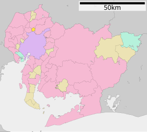
 Map of Nishikasugau District in Aichi Prefecture
Nishikasugai
(
西春日井郡
,
Nishikasugai-gun
)
is a
district
located on the central
Owari Region
in
Aichi Prefecture
,
Japan
.
As of October 1, 2019, the district has a
population
of 15,630 with a
density
of 2,529 per km
2
. The total area is 6.18 km
2
.
Municipalities
[
edit
]
The district consists of one town:
[1]
- Notes
Description
[
edit
]
During the old days, the district extended as far as Nagoya Castle, but since Taisho Era to the 1950s, most of the areas were merged into the city of
Nagoya
.
As of the early 2000's, there were proposals to turn the entire district into a city but the merger was killed due to differences of opinion.
History
[
edit
]
 Map showing original extent of Nishikasugai District in
Aichi Prefecture
:
Map showing original extent of Nishikasugai District in
Aichi Prefecture
:
* yellow - areas formerly within the district borders during the early Meiji period
 Colored areas are in this district.
District Timeline
[
edit
]
- February 5, 1880 -
Kasugai District
was split off into
Higashikasugai
and Nishikasugai Districts during the early
Meiji period
establishment of the municipalities system, which initially consisted of 2 towns and 81 villages. Its district headquarters was located at the village of Shimootai.
- October 1, 1889 - With the establishment of the municipalities system in effect, Nishikasugai District consisted of four towns (Biwajima, Nishibiwajima, Kiyosu and Shimizu) and 34 villages.
- December 17, 1890 - The village of Shinkawa gained town status. (5 towns, 33 villages)
- April 1, 1891 - The establishment of the district/county system was implemented.
- July 16, 1900 - The village of Goj? was formed from parts of the village of Kumanosh? [the section of Yakushiji] and parts of the village of Ogi [the section of Fujishima]. (5 towns, 34 villages)
- September 28, 1900 - The villages of Sukaguchi (Sugaguchi) and Nishihorie merged to form the town of T?ei (Momoe). (6 towns, 32 villages)
- April 1, 1906 - The town of T?ei and the villages of Terano and Ahara were absorbed into the town of Shinkawa. (5 towns, 30 villages)
- July 11, 1906 - The following towns and villages were implemented with the following mergers: (5 towns and 25 villages)
- the village of Yamada: the former villages of Hirata, ?nogi (?noki), Hira, Kamiotai and Nakaotai
- the village of Kusunoki (Kusu): the former villages of Nyoi and Ajima (Ajiki)
- July 16, 1906 - The following towns and villages were implemented with the following mergers: (5 towns and 13 villages)
- the town of Kiyosu: the former town of Kiyosu, and the former villages of Asada and Ichij? (Ichiba)
- the village of Haruhi (Kasuga): the former villages of Shimonog? and Ochiai
- the village of Nishiharu: the former villages of Kunotsubo, Shimojikko and Kamijikko
- the village of Shikatsu (Morakatsu): the former villages of Kunibara (Kunohara), Shikata (Katta), Rokushi and Kumanosh?
- the village of Kitasato: the former villages of Goj?, Ogi (Koki), Owari and Taki
- the village of Toyoyama: the former villages of Toyoba and Aoyama
- October 1, 1909 - Parts of the village of ?zato [section of Nishiichiba] (from
Nakashima District
) were incorporated into the town of Kiyosu.
- October 1, 1910 - Parts of the village of Jimokuji [section of Hazama (Mawari)] (from
Kait? District
, then part of
Ama District
) was incorporated into the town of Kiyosu.
- 1918 - The district had an estimated population of 76,490; with 677 consisting of malaria patients.
- August 22, 1921 - The towns of Biwajima and Shimizu, and the villages of Kanagi (Kinjo), Rokug? and Sugi were merged into the city of Nagoya. Biwajima and Kanagi (Kinjo) would correspond to Nagoya's Nishi-ku; and Shimizu, Rokug? and Sugi would correspond to Nagoya's Higashi-ku. (3 towns, 10 villages)
- April 1, 1923 - The district council was abolished, while the district office remained.
- April 1, 1926 - The village of Sh?nai gained town status. (4 towns, 9 villages)
- July 1, 1926 - The district office was abolished, thus the area remained for geographic purposes.
- April 1, 1933 - The village of Kawanaka was merged into the village of Hagino. (4 towns, 8 villages)
- March 1, 1937 - The town of Sh?nai and the village of Hagino were merged into the city of Nagoya. Both former localities would correspond to Nagoya's Nishi-ku. (3 towns, 7 villages)
- January 1, 1943 - Parts of the town of Jimokuji [sections of Tsuchida and Kamij?] (from
Ama District
) were incorporated into the town of Kiyosu.
- October 1, 1955 - The villages of Yamada and Kusunoki (Kusu) were merged into the city of Nagoya. Yamada would correspond to Nagoya's Nishi-ku; and Kusunoki (Kusu) would correspond to Nagoya's Kita-ku. (3 towns, 5 villages)
- April 1, 1961 - The village of Shikatsu gained town status. (4 towns, 4 villages)
- September 1, 1963 - The village of Kitasato was split off and their sections had been annexed into the town of Shikatsu and the city of Komaki. (4 towns, 3 villages)
- November 1, 1963 - The village of Nishiharu gained town status. (5 towns, 2 villages)
- April 1, 1972 - The village of Toyoyama gained town status. (6 towns, 1 village)
- April 1, 1990 - The village of Haruhi gained town status. (7 towns)
Recent mergers
[
edit
]
Economy
[
edit
]
J-Air
, a subsidiary of
Japan Airlines
, is headquartered in
Toyoyama
, Nishikasugai District, in the
Nagoya Airfield
Terminal Building.
[3]
Nakanihon Air Service
, a general aviation operator, is also located in Toyoyama on the airport grounds.
[4]
References
[
edit
]
External links
[
edit
]
35°15′18″N
136°55′02″E
/
35.2550°N 136.9173°E
/
35.2550; 136.9173
