US Department of Energy reservation in Nevada
The
Nevada National Security Sites
(
N2S2
[1]
or
NNSS
), popularized as the
Nevada Test Site
(
NTS
) until 2010,
[2]
is a reservation of the
United States Department of Energy
located in the southeastern portion of
Nye County
, Nevada, about 65 mi (105 km) northwest of the city of
Las Vegas
.
Formerly known as the
Nevada Proving Grounds
of the
United States Army
, the site was acquired in 1951 to be the testing venue for the American
nuclear devices
. The first
atmospheric test
was conducted at the site's
Frenchman Flat
area by the
United States Atomic Energy Commission
(USAEC) on January 27, 1951. About 928
nuclear tests
were conducted here through 1994, when the United States stopped its underground nuclear testing.
The site consists of about 1,350 sq mi (3,500 km
2
) of desert and mountainous terrain. Some 1,100 buildings in 28 areas are connected by 400 mi (640 km) of paved roads, 300 mi (480 km) miles of unpaved roads, ten
heliports
, and two airstrips. The site is
privately
managed and operated by Mission Support and Test Services LLC, a
joint venture
of
Honeywell
,
Jacobs
, and
Huntington Ingalls
, on behalf of the
National Nuclear Security Administration
(NNSA).
[3]
[4]
The
mushroom clouds
from the 100 atmospheric tests were visible from almost 100 mi (160 km) away; they could be seen from the
Las Vegas Strip
in the early 1950s. Many iconic images at nuclear science museums throughout the United States come from the site.
[5]
Las Vegas
experienced noticeable
seismic
effects.
Westerly winds
routinely carried the
fallout
from atmospheric nuclear tests, increasing
cancer
in
Utah
and elsewhere, according to a 1984 medical report.
[6]
[7]
The site has hosted 536
publicized
and organized
anti-nuclear protests
, with 37,488 participants and 15,740 involved in arrests, according to government records.
[8]
History
[
edit
]
 A map that details the
federal land
in southern Nevada, showing the site
A map that details the
federal land
in southern Nevada, showing the site
The site was established as a 680-square-mile (1,800 km
2
) area by President
Harry S. Truman
on December 18, 1950, within the
Nellis Air Force Gunnery and Bombing Range
.
1951?1992
[
edit
]
 This handbill was distributed 16 days before the first nuclear device was detonated at the site.
The site was the primary testing location of American nuclear devices from 1951 to 1992; 928 announced nuclear tests occurred there. Of those, 828 were underground.
[9]
(Sixty-two of the underground tests included multiple, simultaneous nuclear detonations, adding 93 detonations and bringing the total number of NTS nuclear detonations to 1,021, of which 921 were underground.)
[10]
The site contains many
subsidence craters
from the testing.
The site was the United States' primary location for tests smaller than 1 Mt (4.2 PJ). 126 tests were conducted elsewhere, including most larger tests. Many of these occurred at the
Pacific Proving Grounds
in the
Marshall Islands
.
 Mushroom cloud seen from
downtown Las Vegas
.
Mushroom cloud seen from
downtown Las Vegas
.
During the 1950s, the
mushroom clouds
from atmospheric tests could be seen for almost 100 mi (160 km). The city of Las Vegas experienced noticeable seismic effects, and the distant mushroom clouds, which could be seen from the downtown hotels,
became tourist attractions
. The last atmospheric test detonation at the site was "
Little Feller I
" of
Operation Sunbeam
, on July 17, 1962.
Although the United States did not ratify the
Comprehensive Nuclear-Test-Ban Treaty
, it honors the articles of the treaty, and underground testing of weapons ended as of September 23, 1992. Subcritical tests not involving a
critical mass
continued.
 Sedan crater
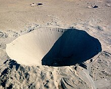
One notable test shot was the "
Sedan
" shot of
Operation Storax
on July 6, 1962, a 104-kiloton-of-TNT (440 TJ) shot for
Operation Plowshare
, which sought to prove that nuclear weapons could be used for peaceful means in creating bays or canals. It
created a crater
1,280 feet (390 m) wide and 320 feet (100 m) deep.
1992?present
[
edit
]
More than 27 subcritical tests have been conducted at the site
[11]
In 2018, the State of Nevada sued the federal government to block a plan to ship "more than a metric ton" of plutonium to the site for temporary storage.
[12]
In 2022, the government acknowledged that 13,625 cubic meters of radioactive material conforming to its disposal criteria had been shipped to the site for disposal.
[13]
Destruction and survivability testing
[
edit
]
 This model two-story house was constructed 10,500 feet (3,200 m) away from the ground-zero of the
Apple-2
nuclear test.
This model two-story house was constructed 10,500 feet (3,200 m) away from the ground-zero of the
Apple-2
nuclear test.
Testing of the various effects of detonation of nuclear weapons was carried out during above-ground tests. Many kinds of vehicles (ranging from cars to aircraft), nuclear-fallout and standard bomb-shelters, public-utility stations and other building structures and equipment were placed at measured distances away from "ground zero", the spot on the surface immediately under or over the center of the blast.
Operation Cue
tested
civil defense
measures.
[14]
Such civilian and commercial effects testing was done with many of the atomic tests of
Operation Greenhouse
on
Eniwetok Atoll
,
Operation Upshot-Knothole
and
Operation Teapot
at the site.
Homes and commercial buildings of many different types and styles were built to standards typical of American and (less-often) European cities. Other such structures included military fortifications (of types used by both
NATO
and the Soviet-led
Warsaw Pact
) and civil-defense as well as "backyard"-type shelters. In such a typical test, several of the same buildings and structures might be built using the same layouts and plans with different types of materials, paints, general landscaping, cleanliness of the surrounding yards, wall-angles or varying distances from ground zero. Mannequins were placed in and around the test vehicles and buildings, aside from some left out in the open, for testing clothing and shock effects.
High-speed cameras were placed in protected locations to capture effects of radiation and shock waves. Typical imagery from these cameras shows paint boiling off the buildings, which are then pushed violently away from ground zero by the shock wave before being drawn toward the detonation by the suction caused by the climbing mushroom cloud. Footage from these cameras has become iconic, used in various media and available in the public domain.
[15]
This testing allowed the development of Civil Defense guidelines, distributed to the public, to increase the likelihood of survival in case of air- or spaceborne nuclear attack.
Environmental impact
[
edit
]
Each of the below-ground explosions?some as deep as 5,000 feet (1.5 km)?vaporized a large chamber, leaving a cavity filled with
radioactive
rubble. About a third of the tests were conducted directly in
aquifers
, and others were hundreds or thousands of feet below the
water table
.
[16]
When underground explosions ended in 1992, the Department of Energy estimated that more than 300 megacuries (11 EBq) of radioactivity remained in the environment at that time, making the site one of the most contaminated locations in the United States. In the most seriously affected zones, the concentration of radioactivity in groundwater reaches millions of picocuries per liter. (The federal standard for drinking water is 20 picocuries per liter (0.74 Bq/L).) Although radioactivity levels in the water continue to decline over time, the longer-lived isotopes like plutonium or uranium could pose risks for thousands of years.
[16]
The Department of Energy has more than 48 monitoring wells at the site. Because the contaminated water poses no immediate health threat, the department ranked the site as low priority for clean-up.
[16]
In 2009,
tritium
with a half-life of 12.3 years was first detected in groundwater off-site in
Pahute Mesa
, near the locations of the 1968 Benham and 1975 Tybo tests.
[17]
The DOE issues an annual
environmental monitoring
report containing data from the monitoring wells both on and off site.
[17]
Janice C. Beatley
started to study the botany of the Nevada test site in 1962 when she created 68 study sites. The intention had been to study the effect of radiation on the plants but this plan had to be changed when the United States abandoned atmospheric testing in 1963. The sites however became important because they recorded long term change through 1980. Much of her data was never published; however it was all transferred to the
United States Geological Survey
after her death. It was "an ideal place to conduct long-term ecosystem research."
[18]
Protests and demonstrations
[
edit
]
 Members of
Desert Lenten Experience
hold a prayer vigil during the Easter period of 1982 at the entrance to the site.
Members of
Desert Lenten Experience
hold a prayer vigil during the Easter period of 1982 at the entrance to the site.
From 1986 through 1994, two years after the United States ended nuclear weapons testing, 536 demonstrations were held at the site involving 37,488 participants and 15,740 arrests, according to government records.
[8]
On February 5, 1987, more than 400 people were arrested trying to enter the site after nearly 2,000 demonstrators held a rally to protest nuclear weapons testing. Those arrested included the astronomer
Carl Sagan
and the actors
Kris Kristofferson
,
Martin Sheen
, and
Robert Blake
. Five Democratic members of Congress attended the rally:
Thomas J. Downey
,
Mike Lowry
,
Jim Bates
,
Leon E. Panetta
, and
Barbara Boxer
.
[19]
[20]
American Peace Test (APT) and Nevada Desert Experience (NDE) held most of these.
[21]
In March 1988, APT held an event where more than 8,000 people attended a ten-day action to "Reclaim the Test Site", where nearly 3,000 people were arrested, including more than 1,200 in one day. This set a record for most civil disobedience arrests in a single protest.
On October 12, 1992, coinciding with the 500 year anniversary of the arrival of Columbus and the beginning of the genocide of indigenous people by Europeans in the Americas, an 11-day protest took place at the Test Site. At the invitation of the Western Shoshone Tribe and
Corbin Harney
, an anti-nuclear activist and spiritual leader for the
Newe
people, over 2000 protesters from 12 different countries gathered for "Healing Global Wounds". In their media work, protesters and organizers demanded an end to nuclear weapons testing and return of the test site to the Western Shoshone people. Camped in the desert, participants took part in anti-racism and peaceful civil disobedience trainings. They planned actions and demonstrations, eventually using culverts and other means to enter the Test Site where 530 were arrested by
Wackenhut
Security forces on charges of trespassing. Full-scale nuclear weapons testing did not resume.
[22]
After 1994, Shundahai Network in cooperation with
Nevada Desert Experience
and
Corbin Harney
continued the protests of the work at the site and staged efforts to stop a repository for highly
radioactive waste
adjacent to the test site at nearby
Yucca Mountain
.
Modern usage
[
edit
]
 WMD
/counter-terrorism training exercise at the site.
WMD
/counter-terrorism training exercise at the site.
The site continues to be used for nuclear weapons research and development. This includes subcritical testing. These tests are conducted jointly by
Los Alamos National Laboratory
,
Lawrence Livermore National Laboratory
, and the British
Atomic Weapons Establishment
. A recent one was
Ediza
(2019),
[23]
and
Nightshade A
(2020).
[24]
The site offers monthly public tours, often booked months in advance. Visitors are not allowed to bring cameras, binoculars, or cell phones, nor are they permitted to pick up rocks for souvenirs.
[25]
[26]
While there are no longer any explosive tests of nuclear weapons at the site, there is still testing done to determine the viability of the United States' aging nuclear arsenal. Additionally, the site is the location of the Area 5 Radioactive Waste Management Complex, which sorts and stores low-level
radioactive waste
that is not
transuranic
and has a half life of less than 20 years.
The Radiological/Nuclear WMD Incident Exercise Site (T-1) replicates multiple terrorist radiological incidents with train, plane, automobile, truck, and helicopter props. It is located in Area 1, at the former site of tests EASY, SIMON, APPLE-2, and GALILEO.
[27]
Landmarks and geography
[
edit
]
A table of interesting places in and around the NNSS is presented here, which corresponds with many of the descriptions in the Nevada Test Site Guide.
[28]
Interesting locations in the NNSS
| Name
|
Location
|
Notes
|
| Mercury
|
Area 23
36°39′34″N
115°59′47″W
/
36.6594°N 115.99642°W
/
36.6594; -115.99642
(
Mercury
)
|
The base housing and office area for the site.
|
| Principal Underground Laboratory for Subcritical Experimentation (PULSE), formerly known as U1a
|
Area 1
37°00′29″N
116°03′32″W
/
37.00819°N 116.05894°W
/
37.00819; -116.05894
(
U1a
)
|
PULSE, formerly known as U1a, is an underground laboratory used for physics experiments that obtain technical information about the U.S. nuclear weapons stockpile. U1h and U1g, shafts which add data access, ventilation and other utilities to the facility, are just north of this entrance.
|
| Industrial area
|
Area 1
37°03′56″N
116°08′03″W
/
37.06561°N 116.13411°W
/
37.06561; -116.13411
(
Industrial area
)
|
Houses $20 million worth of mining tools; contains an area for creating site grout and stemming mixes.
|
| Doomtown
|
Area 5
36°47′53″N
115°56′03″W
/
36.79805°N 115.93416°W
/
36.79805; -115.93416
(
Doomtown
)
|
The original effects test area and close cousin to Survival City in Area 1.
|
| EPA's NTS Dairy
|
Area 15
37°12′30″N
116°02′25″W
/
37.20829°N 116.04037°W
/
37.20829; -116.04037
(
EPA Dairy
)
|
A dairy and pig farm maintained from 1964 to 1984 by the EPA, mainly to provide experimental data for uptake of milk contamination, following
Operation Schooner
.
|
| Yucca Mountain nuclear waste repository
|
Area 25
36°51′10″N
116°25′36″W
/
36.85282°N 116.42672°W
/
36.85282; -116.42672
(
Yucca Mountain
)
|
Yucca Mountain radioactive disposal site. This is the north entrance; the south entrance is about 1.7 miles (2.7 km) SSW.
|
| A Tunnel
|
Area 16
37°00′45″N
116°11′44″W
/
37.01245°N 116.19565°W
/
37.01245; -116.19565
(
A tunnel entrance
)
|
Shoshone Mountain, Tunnel A Entrance.
|
| B Tunnel
|
Area 12
37°11′36″N
116°11′56″W
/
37.19345°N 116.19887°W
/
37.19345; -116.19887
(
B tunnel entrance
)
|
Rainier Mesa
, Tunnel B Entrance.
|
| C, D, and F Tunnels
|
Area 12
37°11′36″N
116°12′00″W
/
37.19322°N 116.19999°W
/
37.19322; -116.19999
(
C, D and F tunnel entrances
)
|
Rainier Mesa, tunnels C, D, and F Entrances ? separate, but very close together.
|
| E Tunnel
|
Area 12
37°11′17″N
116°11′41″W
/
37.18816°N 116.19477°W
/
37.18816; -116.19477
(
E tunnel entrance
)
|
Rainier Mesa, Tunnel E Entrance.
|
| G Tunnel
|
Area 12
37°10′10″N
116°11′41″W
/
37.1694°N 116.1947°W
/
37.1694; -116.1947
(
G tunnel entrance
)
|
Rainier Mesa, Tunnel G Entrance.
|
| I Tunnel
|
Area 12
37°13′08″N
116°09′37″W
/
37.21876°N 116.16036°W
/
37.21876; -116.16036
(
I tunnel entrance
)
|
Rainier Mesa, Tunnel I Entrance.
|
| J Tunnel
|
Area 12
37°13′08″N
116°09′47″W
/
37.21884°N 116.16319°W
/
37.21884; -116.16319
(
J tunnel entrance
)
|
Rainier Mesa, Tunnel J Entrance.
|
| K Tunnel
|
Area 12
37°13′08″N
116°09′32″W
/
37.21878°N 116.15891°W
/
37.21878; -116.15891
(
K tunnel entrance
)
|
Rainier Mesa, Tunnel K Entrance.
|
| N Tunnel
|
Area 12
37°12′06″N
116°11′31″W
/
37.20169°N 116.19187°W
/
37.20169; -116.19187
(
N tunnel entrance
)
|
Rainier Mesa, Tunnel N Entrance.
|
| P Tunnel
|
Area 12
37°13′45″N
116°09′13″W
/
37.22906°N 116.1535°W
/
37.22906; -116.1535
(
P tunnel entrance
)
|
Rainier Mesa, Tunnel P Entrance.
|
| T Tunnel
|
Area 12
37°12′57″N
116°10′02″W
/
37.21589°N 116.16711°W
/
37.21589; -116.16711
(
T tunnel entrance
)
|
Rainier Mesa, Tunnel T Entrance.
|
| X Tunnel
|
Area 25
36°44′44″N
116°19′41″W
/
36.74542°N 116.32816°W
/
36.74542; -116.32816
(
X tunnel entrance
)
|
Two tunnel entrances, used by the U.S. Army Ballistic Research Laboratory for depleted uranium testing.
|
| Operation Icecap
|
Area 7
37°04′51″N
116°02′44″W
/
37.0808°N 116.04558°W
/
37.0808; -116.04558
(
Icecap
)
|
Operation Icecap was being built up when the 1992 Comprehensive Test Ban was signed. The equipment was left in place, including the .5 million pounds (230,000 kg) instrumentation payload, the crane, the wiring, and many of the recording trailers.
|
| Operation Gabbs
|
Area 2
37°08′17″N
116°04′25″W
/
37.13796°N 116.07353°W
/
37.13796; -116.07353
(
Gabbs
)
|
Operation Gabbs was another shaft detonation scheduled for 1993 that was laid to rest by the '92 test ban treaty.
|
| Operation Greenwater
|
Area 20
37°13′51″N
116°26′50″W
/
37.23086°N 116.44725°W
/
37.23086; -116.44725
(
Greenwater
)
|
The third suspended test was Operation Greenwater, the test of the space X-Ray laser system, a part of the
Star Wars concept
. The 45 metres (148 ft) tower remains on the site.
|
| Survival City
|
Area 1
37°03′11″N
116°06′12″W
/
37.05305°N 116.10339°W
/
37.05305; -116.10339
(
Survival City
)
|
The alternative to Doomtown. Used in the Teapot Desert/Rock exercises, and the Civil Defence/PR effort Operation Cue. Name taken from "News of the Day" newsreel about the Apple 2 test.
|
| Fortune Training Area
|
Area 1
36°59′13″N
116°02′38″W
/
36.98689°N 116.04384°W
/
36.98689; -116.04384
(
Fortune Training Area
)
|
Fortune was a training facility for building bomb test sites. Site reused for Unicorn test in 2005?06.
|
| Divine Strake
|
Area 16
37°01′21″N
116°10′55″W
/
37.02245°N 116.18203°W
/
37.02245; -116.18203
(
U16b tunnel, "Divine Strake"
)
|
U16b tunnel entrance complex, including
Divine Strake
proposed 700t chemical blast tunnel on the north, the latter heavily protested, delayed, and eventually abandoned.
|
| Plutonium Valley
|
Area 11
36°58′36″N
115°57′44″W
/
36.97659°N 115.96228°W
/
36.97659; -115.96228
(
Plutonium Valley
)
|
Area contains scattered raw plutonium from plutonium dispersal safety tests.
|
| Original
BREN Tower
|
Area 4
37°05′55″N
116°05′49″W
/
37.09869°N 116.09685°W
/
37.09869; -116.09685
(
BREN original placement
)
|
Original site of the Bare Reactor Experiment in Nevada (BREN), a reactor on a tower which emulated bomb explosions for medical studies. A Japanese village was constructed around it because it focused on war bomb injuries. BREN was later moved to Area 25.
|
| BREN Tower
|
Area 25
36°46′50″N
116°14′37″W
/
36.78062°N 116.24358°W
/
36.78062; -116.24358
(
BREN move here
)
|
The BREN (Bare Reactor Experiment, Nevada) is a 453 m (1,486 ft) tall tower originally in Yucca Flat, used to experimentally irradiate ground targets with gamma and neutrons. Moved to Jackass Flat, for HENRE (High Energy Neutrons Action Experiment) and demolished in 2012.
|
| Nerva
Test Stand
|
Area 25
36°49′54″N
116°16′41″W
/
36.83162°N 116.27809°W
/
36.83162; -116.27809
(
Nerva test stand
)
|
Test stand for the "Nerva" nuclear rocket.
|
| KIWI-TNT
|
Area 25
36°49′58″N
116°16′45″W
/
36.83285°N 116.27914°W
/
36.83285; -116.27914
(
KIWI-TNT
)
|
Test of the Nerva engine to destruction, to determine worst-case scenario for runaway reactor. 1.6 Mci released.
|
| DAF
|
Area 6
36°53′54″N
116°02′53″W
/
36.89827°N 116.04814°W
/
36.89827; -116.04814
(
DAF
)
|
Device Assembly Facility: bombs and components are made ready for testing here.
|
| RWMS-5
|
Area 5
36°51′27″N
115°57′18″W
/
36.85758°N 115.9551°W
/
36.85758; -115.9551
(
RWMS-5
)
|
Radioactive Waste Management Facility, Area 5
|
| E-MAD Building
|
Area 25
36°48′23″N
116°18′17″W
/
36.80646°N 116.30476°W
/
36.80646; -116.30476
(
E-MAD
)
|
Engine Maintenance and Disassembly Building, used for handling radioactive NERVA engines; site being dismantled.
|
| R-MAD Building
|
Area 25
36°48′58″N
116°14′22″W
/
36.8161°N 116.23936°W
/
36.8161; -116.23936
(
R-MAD
)
|
Reactor Maintenance and Disassembly Building, maintained radioactive NERVA reactors. Also used in the MX program; site being dismantled.
|
| ETS-1 Test Stand
|
Area 25
36°49′56″N
116°18′44″W
/
36.8321°N 116.31217°W
/
36.8321; -116.31217
(
ETS-1 test stand
)
|
Engineering Test Stand 1, a stand for testing nuclear rockets in a standard upright position.
|
| MX
Testing Area
|
Area 25
36°41′58″N
116°22′46″W
/
36.69946°N 116.37952°W
/
36.69946; -116.37952
(
MX test area
)
|
MX missile test track and silo
|
| JASPER
|
Area 27
36°46′30″N
116°07′01″W
/
36.77496°N 116.11703°W
/
36.77496; -116.11703
(
JASPER
)
|
Houses the Joint Actinide Shock Physics Experimental Research, a two-stage light-gas gun for shock experiments.
|
| Camp 12
|
Area 12
37°11′46″N
116°09′22″W
/
37.19598°N 116.15624°W
/
37.19598; -116.15624
(
Camp 12
)
|
Camp for miners and others working on the Rainier Mesa in the '70s.
|
| BEEF
|
Area 4
37°05′46″N
116°05′33″W
/
37.09611°N 116.09262°W
/
37.09611; -116.09262
(
BEEF
)
|
Big Explosives Experimental Facility
|
| Area 3 RWMS
|
Area 3
37°02′40″N
116°01′27″W
/
37.04445°N 116.02425°W
/
37.04445; -116.02425
(
RWMS
)
|
Low level Radioactive Waste Management Facility. Waste (mostly dirt) is buried in a selection of old subsidence craters.
|
| Atlas Pulse Power
|
Area 6
36°58′46″N
116°02′23″W
/
36.97946°N 116.03965°W
/
36.97946; -116.03965
(
Atlas Pulse Power
)
|
The Atlas Pulse Power Facility
|
| Apple-2 houses
|
Area 1
37°02′40″N
116°04′26″W
/
37.04434°N 116.07397°W
/
37.04434; -116.07397
(
Apple-2 houses
)
|
Three "typical American" houses built for the Apple-2 civil defense event. The one on the left is 1.5 miles (2.4 km) from the 29kt blast, the right one 2 miles (3.2 km). The left one is on the monthly tour bus route. The two towers are from later seismic studies.
|
| News Nob
|
Area 6
36°56′42″N
116°03′00″W
/
36.945°N 116.05°W
/
36.945; -116.05
(
News Nob
)
|
The location from which VIPs and news people would watch nuclear tests.
|
| Annie Emplacement
|
Area 5
36°42′46″N
115°58′02″W
/
36.7128°N 115.9673°W
/
36.7128; -115.9673
(
Annie emplacement
)
|
Location of "
Atomic Annie
" (M65 280mm nuclear field artillery) emplacement for
Upshot-Knothole Grable
test.
[29]
|
| BACHUS Site
|
Area 12
37°11′44″N
116°09′30″W
/
37.19569°N 116.1584°W
/
37.19569; -116.1584
(
BACHUS
)
|
Biotechnology Activity Characterization by Unconventional Signatures, a biowarfare simulation facility.
|
| Rad/NucCTEC
|
Area 6
36°53′25″N
116°01′51″W
/
36.89026°N 116.03093°W
/
36.89026; -116.03093
(
Rad/NucTEC
)
|
Radiological/Nuclear Countermeasures Test and Evaluation Complex Homeland Security operational nuclear test and training center
|
| Project Pluto
|
Area 26
36°49′03″N
116°08′57″W
/
36.81744°N 116.14906°W
/
36.81744; -116.14906
(
Project Pluto
)
|
Ram-jet nuclear-powered cruise missile engine development project; site being dismantled.
|
| Lockheed-Martin AOF
|
Area 6
36°55′37″N
116°00′27″W
/
36.92692°N 116.00755°W
/
36.92692; -116.00755
(
AOF ? UAV test area
)
|
Aerial Operations Facility; a testing area for UAVs.
|
| Camp Desert Rock
|
Area 22
36°37′33″N
116°01′10″W
/
36.62593°N 116.01937°W
/
36.62593; -116.01937
(
Camp Desert Rock
)
|
The Army Camp that housed the participants in Operations Desert Rock I-VIII. Across the road is the Pig Hilton, where test subjects were housed.
|
| Test Control Point
|
Area 6
36°56′04″N
116°03′17″W
/
36.93453°N 116.05482°W
/
36.93453; -116.05482
(
Test Control Point
)
|
NTS Test control center (CP-1). These two buildings controlled the tests performed at the site.
|
| NNSS-CTOS
|
Area 1
37°03′09″N
116°06′11″W
/
37.05263°N 116.10308°W
/
37.05263; -116.10308
(
CTOS
)
|
Counter Terrorism Operations Support, a location for training in emergency preparedness in radiological emergencies.
|
| Super Kukla
|
Area 27
36°46′45″N
116°06′37″W
/
36.77907°N 116.11041°W
/
36.77907; -116.11041
(
Super Kukla
)
|
A naked reactor test area designed to test equipment under a hostile radioactive environment, 1965?78.
|
| Bleachers
|
Area 5
36°42′05″N
115°58′23″W
/
36.7014°N 115.9731°W
/
36.7014; -115.9731
(
VIP Bleachers
)
|
Bleacher area for viewing of Frenchman Flat events.(14 Atmospheric Tests)
[30]
|
| BODF
|
Area 4
37°04′50″N
116°05′13″W
/
37.08068°N 116.08697°W
/
37.08068; -116.08697
(
BODF
)
|
Buried Objects Detection Facility, area to test and calibrate mine sweeping equipment against buried objects.
|
| Gun Turret
USS
Louisville
|
Area 2
37°08′22″N
116°06′33″W
/
37.13945°N 116.10904°W
/
37.13945; -116.10904
(
Gun Turret
)
|
Used in calibration of
Whitney, Shasta, Diablo
and
Smoky
tests. Made of "old" steel from 1940s U.S. heavy cruiser (USS
Louisville
CA 28) damaged from kamikaze on January 5, 1945; it was "aimed" at the shot cab to get radiation data.
|
| Hazmat Spill Facility
|
Area 5
36°48′05″N
115°57′03″W
/
36.80138°N 115.95075°W
/
36.80138; -115.95075
(
Hazmat Spill Facility
)
|
Hazmat Spill Test Facility ? used to test Hazmat strategies and tactics. Became the Nonproliferation Test and Evaluation Complex in 2005.
|
| RBIFF
|
Area 26
36°48′59″N
116°09′53″W
/
36.81645°N 116.16486°W
/
36.81645; -116.16486
(
RBIFF
)
|
Re-entry Body Impact Fuze Flights
|
| Ship of the Desert
|
Area 5
36°52′29″N
115°55′46″W
/
36.87486°N 115.92957°W
/
36.87486; -115.92957
|
A massive tracked structure designed to capture neutrons from the
Diagonal Line
experiment.
|
| Rock Valley Study
|
Area 25
36°41′03″N
116°11′38″W
/
36.68406°N 116.19397°W
/
36.68406; -116.19397
(
Rock Valley Study
)
|
The circles are the Rock Valley Study Area, environmental research area for studying radiation in the desert ecosystem.
|
| Climax Mine
|
Area 15
37°13′25″N
116°03′32″W
/
37.22352°N 116.05895°W
/
37.22352; -116.05895
(
Climax Mine
)
|
Location of an old silver mine, recycled for three nuclear tests and the Spent Fuel Test in which spent nuclear fuel was stored in a mine drift to study the effects on the granite walls.
|
| The Forest
|
Area 5
36°47′42″N
115°57′04″W
/
36.795°N 115.951°W
/
36.795; -115.951
(
The Forest
)
|
The famous forest on the desert, swept by the blasts of
Encore
and
Grable
.
[31]
|
| The House in the Middle
|
Area 5
36°47′20″N
115°57′17″W
/
36.788757°N 115.954654°W
/
36.788757; -115.954654
(
House in the Middle
)
|
1954 short documentary from the Encore test. A clean, freshly painted house might save your home in a nuclear attack.
[32]
|
Cancer and test site
[
edit
]
 Iodine-131
fallout exposure in
rads
Iodine-131
fallout exposure in
rads
Many communities east of the Nevada Test Site, including
Cedar City
,
Enterprise
, and
St. George, Utah
, received fallout from above-ground
nuclear testing
in the
Yucca Flats
at the site. Winds routinely carried the fallout of these tests directly through St. George and southern Utah. Marked increases in
cancers
such as
leukemia
,
lymphoma
,
thyroid cancer
,
breast cancer
,
melanoma
,
bone cancer
,
brain tumors
, and gastrointestinal tract cancers were reported from the mid-1950s through 1980.
[6]
[7]
On May 19, 1953, the 32-
kiloton
(130
TJ
) atomic bomb (nicknamed "Harry") was detonated at the site. The bomb later gained the name "
Dirty Harry
" because of the amount of off-site
fallout
generated by the bomb.
[33]
A 1962
United States Atomic Energy Commission
report found that "children living in St. George, Utah may have received doses to the
thyroid
of
radioiodine
as high as 120 to 440
rads
" (1.2 to 4.4 Gy).
[34]
A 1979 study reported in the
New England Journal of Medicine
concluded that:
A significant excess of
leukemia
deaths occurred in children up to 14 years of age living in Utah between 1959 and 1967. This excess was concentrated in the cohort of children born between 1951 and 1958, and was most pronounced in those residing in counties receiving high fallout.
[35]
In 1982, a lawsuit brought by nearly 1,200 people accused the government of negligence in atomic and/or nuclear weapons testing at the site, which they said had caused leukemia and other
cancers
. Dr.
Karl Z. Morgan
, Director of Health Physics at
Oak Ridge National Laboratory
, testified that radiation protection measures in the tests were substandard to best practices at the time.
[36]
In a report by the
National Cancer Institute
, released in 1997, it was determined that 90 atmospheric tests at the site deposited high levels of
radioactive
iodine
-
131
(5.5
exabecquerels
) across much of the contiguous United States, especially in the years 1952, 1953, 1955, and 1957 ? doses large enough, it claimed, to produce 10,000 to 75,000 cases of
thyroid cancer
. The
Radiation Exposure Compensation Act
of 1990 allowed for people living downwind of the site for at least two years in particular Nevada, Arizona, or Utah counties, between January 21, 1951, and October 31, 1958, or June 30 and July 31, 1962, and suffering from certain cancers or other serious illnesses deemed to have been caused by fallout exposure to receive compensation of $50,000. By 2014, over 28,000
downwinder
claims for a total compensation of $1.9 billion had been processed.
[37]
Additionally, the
Energy Employees Occupational Illness Compensation Program
Act of 2000 provides compensation and medical benefits for nuclear weapons workers who may have developed certain work-related illnesses.
[38]
Uranium miners, mill workers, and ore transporters are also eligible for $100,000 compassionate payment under the
Radiation Exposure Compensation Program
, while $75,000 is the fixed payment amount for workers who were participants in the above-ground nuclear weapons tests.
Nuclear test series carried out at the site
[
edit
]
Areas
[
edit
]
 Nuclear explosions in various areas of the site
[39]
Nuclear explosions in various areas of the site
[39]
The site is broken down into areas. Some of the areas and their uses include the following:
Area 1
[
edit
]
 Tunnel in the U1a Complex within Area 1
Area 1 held eight nuclear tests for a total of nine detonations.
[9]
Four early atmospheric tests were conducted above Area 1 in the early 1950s, as well as three underground tests in 1971 and 1990. In 1955, a
Civil Defense
experiment (called
Operation Cue
in the press) studied nuclear blast effects on various building types; a few structures still stand.
Heavy drilling equipment and concrete construction facilities are sited in Area 1. Non-destructive X-ray, gamma ray, and subcritical detonation tests continue to be conducted in Area 1.
The radioactivity present on the ground in Area 1 provides a radiologically contaminated environment for the training of
first responders
.
[40]
Area 2
[
edit
]
Area 2 was the site of 144 tests comprising 169 detonations.
[9]
A test named "Gabbs" was intended for early 1993 but was cancelled in 1992 due to a pre-emptive halt to testing based on the
Comprehensive Nuclear-Test-Ban Treaty
.
[41]
Area 3
[
edit
]
Area 3 held 266 nuclear tests for a total of 288 detonations, including Upshot-Knothole 'Harry', more than in any other area of the site.
[9]
As part of
Operation Tinderbox
, on June 24, 1980, a large satellite prototype (
DSCS III
) was subjected to radioactivity from the "Huron King" shot in a vertical line-of-sight (VLOS) test undertaken in Area 3. This was a program to improve the database on nuclear hardening design techniques for defense satellites.
The final nuclear test detonation at site was
Operation Julin
's "Divider" on September 23, 1992, just prior to the moratorium ending all nuclear testing.
[42]
Divider was a safety experiment test shot that was detonated at the bottom of a shaft sunk into Area 3.
In 1995 and 1997, plutonium-contaminated soil from "Double Tracks" and "Clean Slate 1" of
Operation Roller Coaster
(1963) was picked up from the
Tonopah Test Range
and brought to the Area 3 Radioactive Waste Management Site as a first step in eventually returning Tonopah Test Range to an environmentally neutral state. Corrective action regarding the contaminated material from the "Clean Slate 2" and "Clean Slate 3" tests has yet to be agreed upon.
[43]
Area 4
[
edit
]
 Big Explosives Experimental Facility (BEEF) in Area 4
Area 4 held 40 nuclear tests for a total of 44 detonations.
[9]
It is home to the Big Explosives Experimental Facility (BEEF).
[44]
Area 5
[
edit
]
Area 5 held 19 nuclear tests.
[9]
Five atmospheric tests were detonated, starting on January 27, 1951, at Area 5 as part of
Operation Ranger
. These were the first nuclear tests at the site. Further tower detonations were studied at Area 5, and the
Grable
shot which was fired from a
M65 Atomic Cannon
located in Area 11 exploded in Area 5. The
Priscilla
test was conducted at Area 5 on June 24, 1957.
Five underground tests were set up at Area 5; four of those included accidental release of radioactive materials. On March 16, 1968, physicist
Glenn T. Seaborg
toured the upcoming
Milk Shake
shot of
Operation Crosstie
.
[45]
Milk Shake
'
s radioactive release was not detected outside of the site's boundaries.
Area 6
[
edit
]
 Device Assembly Facility in Area 6
 Control Point in Area 6
Area 6 held four nuclear tests for a total of six detonations.
[9]
The area features an asphalt runway, that was constructed on top of a dirt landing strip, that had existed since the 1950s. Some buildings, including a hangar, are situated near the runway.
[46]
The Device Assembly Facility (DAF)
[44]
was originally built to consolidate nuclear explosives assembly operations. It now serves as the Criticality Experiments Facility (CEF).
The Control Point
[44]
is the communication hub of the site. It was used by controllers to trigger and monitor nuclear test explosions.
In 1982, while a live nuclear bomb was being lowered underground, the base
came under attack
by armed combatants. The combatants turned out to be a security team conducting an improperly scheduled drill.
[
citation needed
]
More recently, an airstrip in Area 6 is in use by the Departments of Defense and Homeland security to test UAV sensors.
[47]
Area 7
[
edit
]
Area 7 held 92 nuclear tests.
[9]
During
Operation Buster
, four successful tests were conducted via airdrop, with bomber aircraft releasing nuclear weapons over Area 7.
It is also the site of Matthew Reilly's book called
Area 7
.
Shot "Icecap" planned for 1993 was abandoned in Area 7 following 1992's testing moratorium. The tower, shaft and wiring remain in place, along with a crane intended to lower the nuclear test package into the shaft.
[41]
Area 8
[
edit
]
 Radioactive materials were accidentally released from the 1970 Baneberry shot in Area 8.
Area 8 held 13 nuclear tests for a total of 15 detonations.
[9]
Area 8 hosted the "Baneberry" shot of
Operation Emery
on December 18, 1970. The Baneberry 10 kt (42 TJ) test detonated 900 feet (270 m) below the surface but its energy cracked the soil in unexpected ways, causing a fissure near ground zero and the failure of the shaft stemming and cap.
[48]
A plume of fire and dust was released, raining fallout on workers in different locations within the site. The radioactive plume released 6.7 megacuries (250 PBq) of radioactive material, including 80 kCi (3.0 PBq) of Iodine
131
.
[49]
Area 9
[
edit
]
Area 9 held 115 nuclear tests for a total of 133 detonations.
[9]
In Area 9, the 74 kt (310 TJ) "Hood" test on July 5, 1957, part of
Operation Plumbbob
, was the largest atmospheric test ever conducted within the continental United States; nearly five times larger in yield than the bomb dropped on Hiroshima. A balloon carried Hood up to 460 meters above the ground where it was detonated. Over 2,000 troops took part in the test in order to train them in conducting operations on the nuclear battlefield. 11
megacuries
(410
PBq
) of
iodine-131
(
131
I) were released into the air.
[49]
Area 10
[
edit
]
 North end of Yucca Flat, where most tests have been conducted.
Area 10 held 57 nuclear tests for a total of 71 detonations.
[9]
The first underground test at the site was the "Uncle" shot of
Operation Jangle
. Uncle detonated on November 29, 1951, within a shaft sunk into Area 10.
The "John" shot of Plumbbob, on July 19, 1957, was the first test firing of the nuclear-tipped
AIR-2 Genie
air-to-air rocket designed to destroy incoming enemy bombers with a nuclear explosion. The 2 kt (8.4 TJ) warhead exploded approximately three miles above five volunteers and a photographer who stood unprotected at "ground zero" in Area 10 to show the safety of battlefield nuclear weapons to personnel on the ground.
[50]
The test also demonstrated the ability of a fighter aircraft to deliver a nuclear-tipped rocket and avoid being destroyed in the process. A Northrop
F-89J
fired the rocket.
The
"Sedan" test
of
Operation Storax
on July 6, 1962, a 104 kt (440 TJ) shot for the
Operation Plowshare
which sought to discover whether nuclear weapons could be
used for peaceful means
in creating lakes, bays or canals. The explosion displaced 12 million tons of earth, creating the
Sedan crater
which is 1,280 feet (390 m) wide and 320 feet (100 m) deep.
Area 11
[
edit
]
Area 11 held 9 nuclear tests.
[9]
Four of the tests were weapons safety experiments conducted as
Project 56
; they spread so much radioactive material that Area 11 has been called "Plutonium Valley". As is the case with Area 1, background radiation levels make Area 11 suitable for realistic training in methods of radiation detection.
[43]
Area 12
[
edit
]
Area 12 held 61 nuclear tests between 1957 and 1992, one of which involved two detonations. All tests were conducted below Rainier and Aqueduct mesas.
Area 12 was the primary location for tunnel tests and used almost exclusively for that purpose. The tunnel complexes mined into Rainier and Aqueduct Mesa include the B-, C-, D-, E-, F-, G-, I-, J-, K-, N-, P-, and T-Tunnel complexes, and the R- and S- shafts.
Area 13
[
edit
]
There is no Area 13 within NNSS, though such a name is attached to a section of
Nellis Air Force Range
which abuts the northeastern corner of Area 15.
[51]
Project 57
's weapons safety test was conducted here on April 24, 1957, spreading particles emitting alpha radiation over a large area.
[52]
Area 14
[
edit
]
Area 14 occupies approximately 26 square miles (67 km
2
) in the central portion of the NNSS. Various outdoor experiments are conducted in this area.
[53]
No atmospheric or underground nuclear tests were conducted in Area 14.
[9]
Area 15
[
edit
]
 EPA
farm in Area 15
EPA
farm in Area 15
Three underground detonations took place in area 15 in the 1960s.
[9]
Pile Driver
was a notable
Department of Defense
test. A large underground installation was built to study the survivability of hardened underground bunkers undergoing a nuclear attack. Information from the test was used in designing hardened missile silos and the
North American Aerospace Defense Command
facility in Colorado Springs.
[44]
The abandoned Crystal and Climax mines are found in Area 15. Storage tanks hold contaminated materials.
[44]
From 1964 to 1981, the
Environmental Protection Agency
operated a 36-acre (150,000 m
2
) experimental farm in Area 15. Extensive plant and soil studies evaluated the uptake of pollutants in farm-grown vegetables and from the forage eaten by a dairy herd of some 30
Holstein cows
. Scientists also studied horses, pigs, goats, and chickens.
[44]
Area 16
[
edit
]
Area 16 held six nuclear tests.
[9]
Area 17
[
edit
]
No nuclear tests took place in Area 17.
[9]
Area 18
[
edit
]
Area 18 held five nuclear tests
[9]
and includes the
Pahute Mesa Airstrip
.
[39]
Area 19
[
edit
]
Pahute Mesa is one of four major nuclear test regions within the Nevada National Security Site (NNSS). It occupies 243 square miles (630 km
2
) in the northwest corner of the NNSS. The eastern section is known as Area 19 and the western section as Area 20.
A total of 85 nuclear tests were conducted in Pahute Mesa between 1965 and 1992. Three of them ? Boxcar, Benham and Handley ? had a yield of over one megaton. Three tests were conducted as part of
Operation Plowshare
and one as part of Vela Uniform.
Area 20
[
edit
]
The western section of Pahute Mesa, with a portion of the 85 nuclear tests conducted in the Pahute Mesa occurring in this section.
Area 21
[
edit
]
There is no Area 21 within NNSS, though such a name is attached to a section of
Los Alamos National Laboratory
.
[54]
Area 22
[
edit
]
No nuclear tests took place in Area 22.
[9]
Area 22 once held
Camp Desert Rock
, a staging base for troops undergoing atmospheric nuclear blast training; as many as 9,000 troops camped there in 1955.
Desert Rock Airport
's runway was enlarged to a 7,500 ft (2,300 m) length in 1969 by the
Atomic Energy Commission
. It is a transport hub for personnel and supplies going to NNSS and also serves as an emergency landing strip.
Area 23
[
edit
]
No nuclear tests took place in Area 23.
[9]
The town of
Mercury, Nevada
lies within Area 23. The area is the main pathway to and from NNSS test locations by way of
U.S. Route 95
. An open sanitary landfill is located to the west of Mercury, and a closed hazardous waste site abuts the landfill. Mercury is also the main management area for the site which includes a bar and large cafeteria, printing plant, medical center, warehousing, fleet management, liquidation and recycling center, engineering offices, dormitories, and other administrative areas for both the O&M contractors, LLNL, LANL, and SNL personnel. At its height in the 1950s and '60s, it also held several restaurants, a bowling alley, a movie theater, and a motel.
Area 24
[
edit
]
There is no Area 24 within NNSS, though such a name is attached to a satellite site of the NNSS referred to as the North Las Vegas Facility.
[54]
Area 25
[
edit
]
Area 26
[
edit
]
 Mostly abandoned buildings and structures at Port Gaston
No nuclear tests took place in Area 26,
[9]
the most arid section of the NNSS. An old abandoned mine, the Horn Silver Mine, was used for waste disposal between 1959 and the 1970s; some of the waste is radioactive. Water flow past the shaft could pose a human health risk, so corrective action has been planned.
[55]
In 1983 the
Department of Defense
, the
Department of Energy
, and the
Federal Emergency Management Agency
performed the NUWAX-83 tests near Port Gaston in Area 26, simulating the explosion of a nuclear-armed helicopter and the resulting spread of nuclear debris over 65 acres. The radioactive material used to simulate the accident became inert in less than six months.
[56]
An eight-square-mile complex was constructed in Area 26 in support of
Project Pluto
.
[53]
It consisted of six miles of roads, the critical assembly building, the control building, the assembly and shop buildings, and utilities.
[57]
Those buildings have been used recently as mock reactor facilities in the training of
first responders
.
Area 27
[
edit
]
Area 28
[
edit
]
Area 28 no longer exists; it was absorbed into Areas 25 and 27.
[44]
Area 29
[
edit
]
No nuclear tests took place in Area 29.
[9]
The rugged terrain of Area 29 serves as a buffer between other areas of NNSS. A
helipad
is present at Shoshone Peak.
Area 30
[
edit
]
 The
Crosstie Buggy
test
The
Crosstie Buggy
test
Area 30 occupies approximately 59 square miles (150 km
2
) at the center of the western edge of the NNSS. Area 30 has rugged terrain and includes the northern reaches of Fortymile Canyon. It is used primarily for military training and exercises.
[53]
Area 30 was the site of a single nuclear test, the
Crosstie Buggy
row charge experiment, part of
Operation Plowshare
, which involved five simultaneous detonations.
[9]
See also
[
edit
]
References
[
edit
]
- ^
"Nevada Test Site north of Las Vegas gets new name: Nevada National Security Site, or N2S2"
.
Fox News
. March 20, 2015.
Archived
from the original on August 1, 2017
. Retrieved
July 27,
2017
.
- ^
"Nevada nuclear bomb site given new name"
.
United Press International
. August 23, 2010.
Archived
from the original on August 27, 2010
. Retrieved
August 23,
2010
.
- ^
"NNSA Awards Nevada National Security Site Management & Operating Contract to Mission Support and Test Services, LLC"
.
Archived
from the original on January 15, 2022
. Retrieved
January 13,
2022
.
- ^
"Prime Contracts"
.
NNSS
.
Archived
from the original on January 2, 2022
. Retrieved
January 13,
2022
.
- ^
The Nevada Test Site
.
Emmet Gowin
. Foreword by
Robert Adams
. Princeton and Oxford:
Princeton University Press
, 2019, pp. 148, 157. (Publ. DOE/NV-209, 1993).
- ^
a
b
Johnson, Carl (1984). "Cancer Incidence in an Area of Radioactive Fallout Downwind From the Nevada Test Site".
Journal of the American Medical Association
.
251
(2): 230?6.
doi
:
10.1001/jama.1984.03340260034023
.
PMID
6690781
.
- ^
a
b
Falk, Jim (1982).
Global Fission:The Battle Over Nuclear Power
, p. 134.
- ^
a
b
Western Shoshone spiritual leader dies
[
permanent dead link
]
- ^
a
b
c
d
e
f
g
h
i
j
k
l
m
n
o
p
q
r
s
t
u
v
U.S. Department of Energy / Nevada Operations Office,
United States Nuclear Tests ? July 1945 through September 1992
, December 2000,
DOE/NV-209 Rev 15
Archived
October 12, 2006, at the
Wayback Machine
- ^
"One multiple test took place in Colorado; the other 62 were at NTS"
.
Archived
from the original on September 29, 2007
. Retrieved
January 29,
2008
.
- ^
Frank von Hippel (December 14, 2012).
"Subcritical experiments"
.
Bulletin of the Atomic Scientists
.
Archived
from the original on December 5, 2014
. Retrieved
November 26,
2014
.
- ^
Paul Roupe (December 3, 2018).
"Nevada Balks at Feds' Plan to Store Plutonium Near Vegas"
. Courthouse News.
Archived
from the original on December 4, 2018
. Retrieved
December 4,
2018
.
- ^
"US acknowledges shipping Idaho radioactive waste to Nevada"
.
AP News
. January 12, 2022.
Archived
from the original on January 20, 2022
. Retrieved
January 20,
2022
.
- ^
Teitel, Amy Shira (November 5, 2014),
Operation Cue, A.K.A. Nuking Houses for Emergency Preparedness
,
archived
from the original on May 17, 2016
, retrieved
May 7,
2018
- ^
Operation Cue (1964 revision)
, U.S. Department of Defense, Office of Civil Defense, 1964
, retrieved
May 7,
2018
- ^
a
b
c
Ralph Vartabedian.
Nuclear scars: Tainted water runs beneath Nevada desert
Los Angeles Times
, November 13, 2009.
- ^
a
b
Keith Rogers (November 19, 2014).
"Report: Nuclear testing remnants remain radioactive"
.
Las Vegas Review Journal
.
Archived
from the original on November 28, 2014
. Retrieved
November 26,
2014
.
- ^
"FS-040-01 Monitoring Of Ecosystem Dynamics In The Mojave Desert: The Beatley Permanent Plots"
.
pubs.usgs.gov
.
Archived
from the original on July 5, 2021
. Retrieved
April 21,
2020
.
- ^
Robert Lindsey.
438 Protesters are Arrested at Nevada Nuclear Test Site
Archived
May 11, 2020, at the
Wayback Machine
New York Times
, February 6, 1987.
- ^
"Biggest Demonstration Yet at Test Site"
.
Archived
from the original on May 10, 2016
. Retrieved
December 20,
2015
.
- ^
Political protest and cultural revolution By Barbara Epstein
Archived
May 6, 2024, at the
Wayback Machine
p. 165.
- ^
"At least 530 people demonstrating at a Nevada nuclear..."
– via UPI Archives.
- ^
O'Brien, Nolan (May 24, 2019).
"Subcritical experiment captures scientific measurements to advance stockpile safety"
.
LLNL
.
Archived
from the original on November 5, 2021
. Retrieved
January 16,
2021
.
- ^
Danielson, Jeremy; Bauer, Amy L. (September 2016).
Nightshade Prototype Experiments (Silverleaf)
.
LANL
(Report).
OSTI
.
doi
:
10.2172/1338708
.
OSTI
1338708
.
- ^
U.S. DOE/NNSA ? Nevada Site Office, Nevada National Security Site Tours
Archived
February 19, 2015, at the
Wayback Machine
- ^
"Nevada National Security Site"
.
nnss.gov
.
Archived
from the original on March 15, 2023
. Retrieved
March 15,
2023
.
- ^
Counter Terrorism Operations Support ? WMD Incident Site
Archived
July 25, 2011, at the
Wayback Machine
- ^
Nevada Test Site Guide
(PDF)
(Report). Vol. DOE/NV-715 Rev 1. National Nuclear Security Administration. 2005. Archived from
the original
(PDF)
on February 27, 2013
. Retrieved
December 25,
2013
.
- ^
Desert Research Institute Cultural Resources Report TR118, Project Number188305, DOE/NV/0003590-53
Archived
February 19, 2024, at the
Wayback Machine
, p. 29
- ^
Nevada Test Site Guide DOE/NV-715 Rev. 1, p. 8
- ^
Shots Encore to Climax ? The Final Four Tests of the UPSHOT-KNOTHOLE Series DNA6018F, p. 46
- ^
Desert Research Institute Cultural Resources Report TR118, Project Number188305, DOE/NV/0003590-53
Archived
February 19, 2024, at the
Wayback Machine
, p. 15
- ^
Meeting Dirty Harry in 1953
Archived
June 18, 2013, at the
Wayback Machine
. Chester McQueary,
CommonDreams.org.
- ^
Pat Ortmeyer and Arjun Makhijani. "
Let Them Drink Milk
Archived
August 20, 2014, at the
Wayback Machine
,"
The Bulletin of the Atomic Scientists
, November/December 1997, via
IEER
Archived
April 13, 2012, at the
Wayback Machine
. Retrieved October 31, 2007.
- ^
Gerald H. Clarfield and William M. Wiecek (1984).
Nuclear America: Military and Civilian Nuclear Power in the United States 1940?1980
, Harper & Row, New York, p. 215.
- ^
"Karl Z. Morgan, 91, Founder of the Field Of Health Physics, Dies in Tennessee"
.
Archived
from the original on May 6, 2024
. Retrieved
February 11,
2017
.
- ^
"Radiation Exposure Compensation System: Claims to Date Summary of Claims Received by 05/08/2014"
(PDF)
.
Archived
(PDF)
from the original on September 7, 2009
. Retrieved
February 24,
2006
.
- ^
Office of Compensation Analysis and Support
Archived
September 10, 2017, at the
Wayback Machine
. National Institute for Occupational Safety and Health.
- ^
a
b
United States Geological Survey.
Geologic Surface Effects of Underground Nuclear Testing
Archived
March 25, 2009, at the
Wayback Machine
. Accessed on April 18, 2009.
- ^
First Responder Training
Archived
September 30, 2011, at the
Wayback Machine
.
US Department of Energy. Nevada Operations Office. National Security. Homeland Security
- ^
a
b
National Nuclear Security Administration / Nevada Site Office (January 2011).
"Icecap"
(PDF)
.
Fact Sheets
. Archived from
the original
(PDF)
on September 27, 2011
. Retrieved
December 2,
2011
.
- ^
Gross, Daniel A. (2016).
"An Aging Army"
.
Distillations
.
2
(1): 26?36.
Archived
from the original on March 20, 2018
. Retrieved
March 20,
2018
.
- ^
a
b
National Nuclear Security Administration / Nevada Site Office (April 2010).
"Plutonium Dispersal Tests at the Nevada Test Site"
(PDF)
.
Fact Sheets
. Archived from
the original
(PDF)
on September 27, 2011
. Retrieved
December 2,
2011
.
- ^
a
b
c
d
e
f
g
Nevada Test Site Guide
, National Nuclear Security Administration,
DOE/NV-715
Archived
October 16, 2011, at the
Wayback Machine
- ^
Radiochemistry.org. History. Nuke tests
Archived
June 20, 2010, at the
Wayback Machine
.
Nevada Test Site Images
(cdrom 3; PDF file)
- ^
Rogers, Keith (March 5, 2016).
"You know Area 51, but just what in the world is Area 6?"
.
Las Vegas Review-Journal
.
Archived
from the original on March 6, 2016
. Retrieved
March 5,
2016
.
- ^
"You know Area 51, but just what in the world is Area 6?"
.
Las Vegas Review-Journal
. March 5, 2016.
Archived
from the original on December 5, 2023
. Retrieved
April 14,
2024
.
- ^
"Lawrence Livermore National Laboratory. News Archive. Tarabay H. Antoun.
Three Dimensional Simulation of the Baneberry Nuclear Event
"
(PDF)
. Archived from
the original
(PDF)
on May 27, 2010
. Retrieved
April 24,
2010
.
- ^
a
b
"National Cancer Institute. National Institute of Health.
History of the Nevada Test Site and Nuclear Testing Background
"
(PDF)
. Archived from
the original
(PDF)
on December 21, 2010
. Retrieved
April 24,
2010
.
- ^
"California Literary Review. Peter Kuran. Images from
How To Photograph an Atomic Bomb
. (22 October 2007)"
. Archived from
the original
on May 24, 2012
. Retrieved
April 24,
2010
.
- ^
Nevada Division of Environmental Protection. Bureau of Federal Facilities. Federal Facility Agreement & Consent Order.
FFACO Description of Facilities
Archived
June 6, 2013, at the
Wayback Machine
- ^
"Operation PLUMBBOB. Summary Report, Test Group 57, Nevada Test Site"
. Defense Nuclear Agency. October 10, 1958. Archived from
the original
on August 23, 2011
. Retrieved
December 18,
2010
.
- ^
a
b
c
National Nuclear Security Administration / Nevada Site Office,
Draft Site-Wide Environmental Impact Statement Nevada
, ch.2, July 2011,
DOE/EIS-246-D
Archived
October 18, 2011, at the
Wayback Machine
- ^
a
b
"Gizmodo.
Why Is It Called Area 51
"
.
Archived
from the original on October 8, 2019
. Retrieved
October 8,
2019
.
- ^
DOE Scientific and Technical Information.
Corrective Action Investigation Plan for Corrective Action Unit 527: Horn Silver Mine, Nevada Test Site, Nevada: Revision 1 (Including Records of Technical Change No. 1, 2, 3, and 4)
(6 December 2002)
Archived
May 25, 2011, at the
Wayback Machine
doi
:
10.2172/818649
- ^
Associated Press (May 6, 1983).
"Nevada, US Simulate Nuclear Accident"
.
Lakeland Ledger
.
Archived
from the original on April 25, 2023
. Retrieved
May 13,
2015
.
- ^
National Nuclear Security Administration / Nevada Site Office (April 2010).
"Project Pluto"
(PDF)
.
Fact Sheets
. Archived from
the original
(PDF)
on March 3, 2012
. Retrieved
December 2,
2011
.
External links
[
edit
]
- HABS No. NV-26-A, "
Nevada Test Site, Reactor Maintenance & Disassembly Complex, Junior Hot Cell, Jackass Flats, Area 25, South of intersection of Roads F & G, Mercury, Nye County, NV
"
- HABS No. NV-27, "
Nevada Test Site, Japanese Village, Area 4, Yucca Flat, 4-04 Road near Rainier Mesa Road, Mercury, Nye County, NV
"
- HABS No. NV-27-A, "
Nevada Test Site, Japanese Village, Type B Structure
"
- HABS No. NV-27-B, "
Nevada Test Site, Japanese Village, Type C Structure
"
- HABS No. NV-27-C, "
Nevada Test Site, Japanese Village, Type C Elevation
"
- HABS No. NV-28, "
Nevada Test Site, Environmental Protection Agency Farm, Area 15, Yucca Flat, 10-2 Road near Circle Road, Mercury, Nye County, NV
"
- HABS No. NV-28-A, "
Nevada Test Site, Environmental Protection Agency Farm, Laboratory Building
"
- HABS No. NV-28-B, "
Nevada Test Site, Environmental Protection Agency Farm, Storage Shed
"
- HABS No. NV-28-C, "
Nevada Test Site, Environmental Protection Agency Farm, Silo Type
"
- HABS No. NV-28-D, "
Nevada Test Site, Environmental Protection Agency Farm, Quonset Hut Type
"
- HABS No. NV-28-E, "
Nevada Test Site, Environmental Protection Agency Farm, Shelter Unit Type
"
- HABS No. NV-28-F, "
Nevada Test Site, Environmental Protection Agency Farm, Weather Tower
"
- HABS No. NV-28-G, "
Nevada Test Site, Environmental Protection Agency Farm, Power Substation
"
- HAER No. NV-25, "
Nevada Test Site, Engine Maintenance Assembly & Disassembly Facility, Area 25, Jackass Flats, Mercury, Nye County, NV
"
- HAER No. NV-29-A, "
Nevada Test Site, Reactor Maintenance Assembly & Disassembly Facility, Area 25, Jackass Flats, Junction of Roads F & G, Mercury, Nye County, NV
"
- HAER No. NV-30-A, "
Nevada Test Site, Test Cell C Facility, Building No. 3210, Area 25, Jackass Flats, Road J, Mercury, Nye County, NV
"
- HAER No. NV-30-B, "
Nevada Test Site, Test Cell C Facility, Elevated Water Tower
"
- HAER No. NV-30-C, "
Nevada Test Site, Test Cell C Facility, West Camera Bunker
"
- HAER No. NV-31, "
Nevada Test Site, Super Kukla Facility, Area 27, Rock Valley, South of Cane Spring Road, Mercury, Nye County, NV
"
- HAER No. NV-31-A, "
Nevada Test Site, Super Kukla Facility, Containment Building
"
- HAER No. NV-31-B, "
Nevada Test Site, Super Kukla Facility, High Bay
"
- HAER No. NV-32, "
Nevada Test Site, Pluto Facility, Area 26, Wahmonie Flats, Cane Spring Road, Mercury vicinity, Nye County, NV
"
- HAER No. NV-32-A, "
Nevada Test Site, Pluto Facility, Disassembly Building
"
- HAER No. NV-32-B, "
Nevada Test Site, Pluto Facility, Guard House
"
- HAER No. NV-32-C, "
Nevada Test Site, Pluto Facility, Water Filtering System Brock House
"
- HAER No. NV-32-D, "
Nevada Test Site, Pluto Facility, Water Tower
"
- HAER No. NV-32-E, "
Nevada Test Site, Pluto Facility, Test Car Wash Stand
"
- HAER No. NV-33, "
Nevada Test Site, Test Cell A Facility, Area 25, Jackass Flats, Road F, Mercury, Nye County, NV
"
- HAER No. NV-33-A, "
Nevada Test Site, Test Cell A Facility, Test Cell A Building & Addition
"
- HAER No. NV-33-B, "
Nevada Test Site, Test Cell A Facility, Tunnel
"
- HAER No. NV-33-C, "
Nevada Test Site, Test Cell A Facility, Spherical Dewar
"
- HAER No. NV-33-D, "
Nevada Test Site, Test Cell A Facility, Moveable Shed
"
- HAER No. NV-33-E, "
Nevada Test Site, Test Cell A Facility, Bunker
"
- HAER No. NV-37-A, "
Nevada Test Site, Frenchman Flat Test Facility, Main Switching Bunker, Intersection of 5-03 Road & Short Pole Line Road, Area 5, Frenchman Flat, Mercury, Nye County, NV
"
- HAER No. NV-37-B, "
Nevada Test Site, Frenchman Flat Test Facility, Well Five Booster Stations
"
- HAER No. NV-47, "
Nevada Test Site, BREN Tower Complex, Jackass Flats, Area 25, Mercury, Nye County, NV
"
|
|---|
| Operations
| |
|---|
Test
areas
| | New Mexico
| |
|---|
| Nevada
| |
|---|
| Mississippi
| |
|---|
| Alaska
| |
|---|
| Colorado
| |
|---|
| Other
| |
|---|
|
|---|
Related
topics
| |
|---|
|
|---|
| General
| |
|---|
Organizations
and
groups
| |
|---|
| People
| |
|---|
Main
protest
sites
| |
|---|
| Books
| |
|---|
| Films
| |
|---|