River in Russia
| Neva
|
|---|
 |
 Location of the Neva
|
| Native name
| Нева
(
Russian
)
|
|---|
|
| Location
| Northern Europe
|
|---|
| Country
| Russian Federation
|
|---|
| Region
| Leningrad Oblast
,
Saint Petersburg
|
|---|
| Cities
| Shlisselburg
,
Kirovsk
,
Otradnoye
,
Saint Petersburg
|
|---|
|
|
| Source
| Lake Ladoga
|
|---|
| • coordinates
| 59°57′10″N
31°02′10″E
/
59.95278°N 31.03611°E
/
59.95278; 31.03611
|
|---|
| • elevation
| 4.3 m (14 ft)
|
|---|
|
|
| Mouth
| Neva Bay
|
|---|
• coordinates
| 59°57′50″N
30°13′20″E
/
59.96389°N 30.22222°E
/
59.96389; 30.22222
|
|---|
• elevation
| 0 m (0 ft)
|
|---|
| Length
| 74 km (46 mi)
|
|---|
| Basin size
| 282,300 km
2
(109,000 sq mi)
|
|---|
| Width
|
|
|---|
| • minimum
| 210 metres (690 ft)
|
|---|
|
| Discharge
|
|
|---|
| • location
| Saint Petersburg
,
Gulf of Finland
(near mouth)
|
|---|
| • average
| 2,628 m
3
/s (92,800 cu ft/s)
|
|---|
| • maximum
| 4,550 m
3
/s (161,000 cu ft/s)
|
|---|
|
|
|
| Tributaries
|
|
|---|
| • left
| Mga
,
Tosna
,
Izhora
|
|---|
| • right
| Okhta
|
|---|
 Basin of Neva River
The
Neva
(
NEE
-v?
,
NAY
-v?
;
Russian
:
Нева?
,
IPA:
[n???va]
ⓘ
) is a
river
in northwestern
Russia
flowing from
Lake Ladoga
through the western part of
Leningrad Oblast
(historical region of
Ingria
) to the
Neva Bay
of the
Gulf of Finland
. Despite its modest length of 74 kilometres (46 mi), it is the fourth-largest river in
Europe
in terms of average
discharge
(after the
Volga
, the
Danube
and the
Rhine
).
[1]
The Neva is the only river flowing from Lake Ladoga. It flows through the city of
Saint Petersburg
, the three smaller towns of
Shlisselburg
,
Kirovsk
and
Otradnoye
, and dozens of settlements. It is navigable throughout and is part of the
Volga?Baltic Waterway
and
White Sea?Baltic Canal
. It is the site of many major historical events, including the
Battle of the Neva
in 1240 which gave
Alexander Nevsky
his name, the founding of Saint Petersburg in 1703, and the
Siege of Leningrad
by the German army during
World War II
. The river played a vital role in trade between
Byzantium
and
Scandinavia
.
Etymology
[
edit
]
The earliest people in recorded history known to have inhabited the area are the
Finnic people
.
Neva
is widespread in
Finnic languages
, having quite
cognate
meanings. In
Finnish
it means
poor fen
, in
Karelian
: watercourse and in
Estonian
(as
nova
): waterway.
[2]
It has been postulated the name could derive from
Indo-European
adjective
new?
which means new ? the river began its flow some time between 2000
BC
and 1250 BC. However, the local place names with such influence coincide with Scandinavian traders and Slavs' first main settlement in the region, in the 8th century AD.
[2]
Description
[
edit
]
History of the delta
[
edit
]
In the
Paleozoic
, 300?400 million years ago, all the delta region was covered by a sea. Modern relief, eminences, were formed by glacial scouring. Its retreat formed the
Littorina Sea
, the level of which was 7 to 9 metres (23 to 30 ft) higher than its successor the Baltic Sea. Then, the
Tosna
was flowing in the modern lower half of the Neva as today, into the Litorinal Sea. In the north of the
Karelian Isthmus
, the sea was united by a wide strait with
Lake Ladoga
. The
Mga
then flowed to the east, into Lake Ladoga, near the modern source of the Neva. Thus the Mga then was separate from the Tosna/lower-Neva basin.
[3]
Near the modern Lake Ladoga, by
glacial rebound
land rose faster, and an endorheic lake briefly formed. This overspilled, eventually the whole Mga valley and thus broke into the western valley (the valley of the Tosna/lower-Neva). The Ivanovo
rapids
of the modern Neva were created at the breakthrough. According to early books, the breakthrough may have been about 2000 BC, but according to more recent research, this happened at 1410?1250 BC, making the river rather young.
[4]
The valley is lined with glacial and post-glacial sediments and has changed little over 2,500 years.
[5]
The delta was formed at that time, technically a pseudodelta, as not from accumulation of river material but by scouring past sediments.
[6]
Topography and hydrography
[
edit
]
The Neva flows out of Lake Ladoga near
Shlisselburg
, flows through Neva's lowlands and discharges into the
Baltic Sea
in the
Gulf of Finland
. It has a length of 74 kilometres (46 mi), and the shortest distance from the source to the mouth is 45 kilometres (28 mi). The river banks are low and steep, on average about 3 to 6 metres (10 to 20 ft) and 2 to 3 metres (7 to 10 ft) at the mouth. There are three sharp turns: the Ivanovskye rapids, at Nevsky Forest Park of the Ust-Slavyanka region (the so-called "Crooked Knee"), and near the
Smolny Institute
, below the mouth of the river
Okhta
.
[6]
The river declines 4.27 metres (14.0 ft) in elevation between source and mouth.
[1]
At one point the river crosses a
moraine
ridge and forms the Ivanovskye rapids. There, at the beginning of the rapids, is the narrowest part of the river: 210 metres (690 ft). The average flow rate in the rapids is about 0.8?1.1 metres per second (2.6?3.6 ft/s). The average width along the river is 400 to 600 metres (1,300 to 2,000 ft). The widest places, at 1,000 to 1,250 metres (3,280 to 4,100 ft), are in the delta, near the gates of the marine trading port, at the end of the Ivanovskye rapids near the confluence of the river Tosna, and near the island Fabrinchny near the source. The average depth is 8 to 11 metres (26 to 36 ft); the maximum of 24 metres (79 ft) is reached above the
Liteyny Bridge
, and the minimum of 4.0 to 4.5 metres (13 to 15 ft) is in Ivanovskye rapids.
[7]
In the Neva basin, rainfall greatly exceeds evaporation; the latter accounts for only 37.7 percent of the water consumption from Neva and the remaining 62.3 percent is water runoff.
[8]
Since 1859, the largest volume of 116 cubic kilometres (28
cu mi
) was observed in 1924 and the lowest in 1900 at 40.2 cubic kilometres (9.6 cu mi).
[6]
The average annual discharge is 78.9 cubic kilometres (18.9 cu mi) or 2,500 cubic metres per second (88,000 cu ft/s) on average.
[1]
Due to the uniform water flow from Lake Ladoga to the Neva over the whole year, there are almost no floods and corresponding water rise in the spring. The Neva freezes throughout from early December to early April. The ice thickness is 0.3 to 0.4 metres (1.0 to 1.3 ft) within Saint Petersburg and 0.5 to 0.6 metres (1.6 to 2.0 ft) in other areas. Ice congestion may form in winter in the upper reaches of the river, this sometimes causes upstream floods. Of the total ice volume of Lake Ladoga, 10.6 cubic kilometres (2.5 cu mi), less than 5 percent enters the Neva.
[8]
The average summer water temperature is 17 to 20 °C (63 to 68 °F), and the swimming season lasts only about 1.5 months. The water is fresh, with medium turbidity; the average salinity is 61.3 mg/L and the
calcium bicarbonate
content is 7 mg/L.
[6]
Average
streamflow
. Values in brackets are percentage of the annual values.
[8]
| Quantity
|
April to June
|
July to September
|
October to November
|
December to March
|
Total
|
| Runoff, km
3
|
22.7 (28.5%)
|
23.5 (29.4%)
|
14.1 (17.7%)
|
19.4 (24.4%)
|
79.7
|
| Suspended sediment,
kt
|
162 (31.7%)
|
136 (26.7%)
|
143 (28.0%)
|
69 (13.6%)
|
510
|
| Bottom sediments, kt
|
26.5 (40.8%)
|
15.8 (24.3%)
|
21.3 (32.7%)
|
1.4 ( 2.2%)
|
65.0
|
| Ions runoff, kt
|
735 (25.6%)
|
729 (25.4%)
|
712 (24.8%)
|
694 (24.2%)
|
2870
|
| Heat sink, 10
15
cal
|
168 (28.4%)
|
359 (60.7%)
|
63 (10.7%)
|
1 (0.2%)
|
591
|
| Ice runoff, km
3
|
0.57 (81.4%)
|
?
|
0.13 (18.6%)
|
?
|
0.7
|
Basin, tributaries and distributaries
[
edit
]
The basin area of Neva is 5,000 km
2
,
[9]
including the pools of Lake Ladoga and Onega (281,000 km
2
). The basin contains 26,300 lakes and has a complex hydrological network of more than 48,300 rivers, however only 26 flow directly into Neva. The main tributaries are
Mga
,
Tosna
,
Izhora
,
Slavyanka
and Murzinka on the left, and
Okhta
and
Chyornaya Rechka
on the right side of Neva.
[6]
The hydrological network had been altered by the development of Saint Petersburg through its entire history. When it was founded in 1703, the area was low and swampy and required construction of canals and ponds for drainage. The earth excavated during their construction was used to raise the city. At the end of the 19th century, the delta of Neva consisted of 48 rivers and canals and 101 islands. The most significant distributaries of the delta are listed in the table. Before construction of the
Obvodny Canal
, the left tributary of that area was the Volkovka; its part at the confluence is now called Monastyrka. The
Ladoga Canal
starts at the root of Neva and connects it along the southern coast of Lake Ladoga with the
Volkhov
.
[10]
Some canals of the delta were filled over time, so that only 42 islands remained by 1972, all within the city limits of St. Petersburg. The largest islands are
Vasilyevsky
at 1,050 hectares (2,600 acres),
Petrogradsky
at 570 hectares (1,400 acres),
Krestovsky
at 420 hectares (1,000 acres), and
Dekabristov
at 410 hectares (1,000 acres); others include
Zayachy
, Yelagin and
Kamenny Islands
.
[10]
At the source of the Neva, near Shlisselburg, there are the two small islands of Orekhovy and Fabrichny. Island Glavryba lies up the river, above the town of
Otradnoye
.
English map of 1834 depicting the city centre and the names of Neva arms
Flora and fauna
[
edit
]
There is almost no aquatic vegetation in Neva. The river banks mostly consist of sand,
podsol
,
gleysols
,
peat
, and boggy peat soils.
[12]
Several centuries ago, the whole territory of the Neva lowland was covered by
pine
and
spruce
mossy
forests. They were gradually reduced by the fires and cutting for technical needs. Extensive damage was caused during
World War II
: in Saint Petersburg, the forests were reduced completely, and in the upper reaches down to 40 to 50 percent.
[13]
Forest were replanted after the war with spruce, pine,
cedar
,
Siberian larch
,
oak
,
Norway maple
,
elm
, America,
ash
,
apple
tree,
mountain ash
and other species. The shrubs include
barberry
,
lilac
,
jasmine
,
hazel
,
honeysuckle
,
hawthorn
,
rose hip
,
viburnum
,
juniper
,
elder
,
shadbush
and many others.
[14]
 Birch forest
Nowadays, the upper regions of the river are dominated by
birch
and pine-birch grass-shrub forests and in the middle regions there are swampy pine forests.
[12]
In St. Petersburg, along the Neva, there are many gardens and parks, including the
Summer Garden
,
Field of Mars
, Rumyantsev,
Smolny
,
Alexander Gardens
, Garden of the
Alexander Nevsky Lavra
and many others.
[10]
Because of the rapid flow, cold water and lack of quiet pools and aquatic vegetation the diversity of fish species in Neva is small. Permanent residents include such undemanding to environment species as
perch
,
ruffe
and
roaches
. Many fish species are transitory, of which commercial value have
smelt
,
vendace
and partly
salmon
.
[15]
Floods
[
edit
]
Floods in St. Petersburg are usually caused by the overflow of the delta of Neva and by surging water in the eastern part of
Neva Bay
. They are registered when the water rises above 160 centimetres (63 in) with respect to a gauge at the
Mining Institute
. More than 300 floods occurred after the city was founded in 1703.
[16]
[17]
[18]
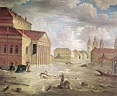
Three of them were catastrophic: on 7 November 1824, when water rose to 421 centimetres (166 in); on 23 September 1924 when it reached 369 centimetres (145 in), and 10 September 1777 when it rose to 321 centimetres (126 in).
[15]
However, a much larger flood of 760 centimetres (300 in) was described in 1691.
[19]
Besides flooding as a result of tidal waves, in 1903, 1921 and 1956 floods were caused by the melting of snow.
[20]
Floods in St. Petersburg
|

|

|
|
| 7 November 1824, in front of
Bolshoi Theatre
|
7 November 1824
|
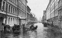
Sadovaya Street
near the former Nikolsky Market, 15 November 1903
|
Bolshaya Podyacheskaya Street, 25 November 1903
|
|
|
|

|
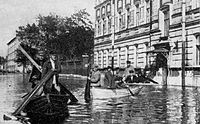
| Boat transportation over
Vasilievsky Island
during the flood of 23 September 1924
|
Vladimirsky Avenue after the flood of 1924
|
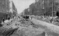
A pier during the flood of 18 October 1967
|
Near the
Mining Institute
on 18 October 1967
|
Ecological condition
[
edit
]
The Federal Service for Hydrometeorology and Environmental Monitoring of Russia classifies the Neva as a "heavily polluted" river. The main pollutants include
copper
,
zinc
,
manganese
,
nitrites
and
nitrogen
. The dirtiest tributaries of the Neva are the Mga, Slavyanka, Ohta, and Chernaya.
[21]
Hundreds of factories pour wastewater into the Neva within St. Petersburg, and
petroleum
is regularly transported along the river. The annual influx of pollutants is 80,000 tonnes,
[22]
and the heaviest polluters are Power-and-heating Plant 2 (
Russian
:
ТЭЦ-2
), "Plastpolymer" and "
Obukhov State Plant
". The biggest polluters in the Leningrad Oblast are the cities of Shlisselburg, Kirovsk and Otradnoye, as well as the Kirov
thermal power station
. More than 40 oil spills are registered on the river every year.
[23]
In 2008, the Federal Service of St. Petersburg announced that no beach of the Neva was fit for swimming.
[22]
Cleaning of wastewater in Saint Petersburg started in 1979; by 1997, about 74% was purified. This rose to 85% in 2005, to 91.7% by 2008, and Feliks Karamzinov expected it to reach almost 100% by 2011 with the completion of the expansion of the main sewerage plant.
[24]
History
[
edit
]
Before 1700
[
edit
]
Many sites of ancient people, up to nine thousand years old, were found within the territory of the Neva basin. It is believed that around twelve thousand years BC,
Finnic people
(
Votes
and
Izhorians
) moved to this area from the
Ural Mountains
.
[25]
In the 8th and 9th centuries AD, the area was inhabited by the
East Slavs
who were mainly engaged in
slash and burn
agriculture, hunting and fishing. From the 8th to 13th centuries, Neva provided a waterway from Scandinavia to the
Byzantine Empire
. In the 9th century, the area belonged to
Veliky Novgorod
.
[26]
The Neva was already mentioned in the
Life of Alexander Nevsky
(13th century).
[27]
At that time, Veliky Novgorod was engaged in nearly constant wars with Sweden. A major battle occurred on 15 July 1240 at the confluence of the Izhora and Neva Rivers. The Russian army, led by the 20-year-old Prince
Alexander Yaroslavich
, aimed to stop the planned Swedish invasion. The Swedish army was defeated; the prince showed personal courage in combat and received the honorary name of "Nevsky".
[28]
[29]
As a result of the Russian defeat in the
Ingrian War
of 1610?17 and the concomitant
Treaty of Stolbovo
, the area of the Neva River became part of
Swedish Ingria
. Beginning in 1642, the capital of Ingria was Nyen, a city near the
Nyenschantz
fortress. Because of financial and religious oppression, much of the
Orthodox
population left the Neva region, emptying 60 percent of the villages by 1620. The abandoned areas became populated by people from the
Karelian Isthmus
and
Savonia
.
[30]
Russian period
[
edit
]
As a result of the
Great Northern War
of 1700?21, the valley of Neva River became part of
Russian Empire
. On 16 May 1703, the city of St. Petersburg was founded in the mouth of Neva and became capital of Russia in 1712.
[26]
Neva became the central part of the city. It was cleaned, intersected with canals and enclosed with embankments. In 1715, construction began of the first wooden embankment between the
Admiralty building
and the
Summer Garden
. In the early 1760s works started to cover it in
granite
and to build bridges across Neva and its canals and tributaries, such as the
Hermitage Bridge
.
[6]
From 1727 to 1916, the temporary
Isaakievsky pontoon bridge
was early constructed between the modern
Saint Isaac's Square
and
Vasilievsky Island
. A similar, but much longer Trinity pontoon bridge, which spanned 500 metres (1,600 ft), was brought from the Summer Garden to
Petrogradsky Island
. The first permanent bridge across Neva,
Blagoveshchensky Bridge
, was opened in 1850, and the second,
Liteyny Bridge
, came into operation in 1879.
[6]
In 1858, a "Joint-stock company St. Petersburg water supply" was established, which built the first water supply network in the city. A two-stage water purification station was constructed in 1911. The development of the sewerage system began only in 1920, after the
October Revolution
, and by 1941, the sewerage network was 1,130 kilometres (700 mi) long.
[6]
Every winter from 1895 to 1910, electric
tramways
were laid on the ice of the river, connecting the
Senate Square
,
Vasilievsky island
,
Palace Embankment
and other parts of the city. The power was supplied through the rails and a top cable supported by wooden piles frozen into the ice. The service was highly successful and ran without major accidents except for a few failures in the top electrical wires. The trams ran at the speed of 20 kilometres per hour (12 mph) and could carry 20 passengers per carriage. The carriages were converted from the used
horsecars
. About 900,000 passengers were transported over a regular season between 20 January and 21 March. The sparking of contacts at the top wires amused spectators in the night.
[31]
[32]
[33]
[34]
Soviet and modern periods
[
edit
]
The first concrete bridge across Neva, the
Volodarsky Bridge
, was built in 1936.
[35]
During World War II, from 8 September 1941 to 27 January 1944, Leningrad was in the devastating
German Siege
. On 30 August 1941, the German army captured Mga and came to Neva. On 8 September Germans captured Shlisselburg and cut all land communications and waterways to St. Petersburg (then Leningrad). The siege was partly relieved in January 1943, and ended on 27 January 1944.
[26]
A river station was built above the Volodarsky Bridge in 1970 which could accept 10 large ships at a time. Wastewater treatment plants were built in Krasnoselsk in 1978, on the Belyi Island in 1979?83, and in
Olgino
in 1987?94. The South-West Wastewater Treatment Plant was constructed in 2003?05.
[6]
Commercial use
[
edit
]
Neva has very few shoals and its banks are steep, making the river suited for navigation. Utkino Backwaters were constructed in the late 19th century to park unused ships. Neva is part of the major
Volga?Baltic Waterway
and
White Sea ? Baltic Canal
, however it has relatively low transport capacity because of its width, depth and bridges. Neva is available for vessels with capacity below 5,000 tonnes. Major transported goods include timber from
Arkhangelsk
and
Vologda
;
apatite
,
granite
and
diabase
from
Kola Peninsula
;
cast iron
and
steel
from
Cherepovets
; coal from
Donetsk
and
Kuznetsk
;
pyrite
from Ural;
potassium chloride
from
Solikamsk
; oil from
Volga
region. There are also many passenger routes to
Moscow
,
Astrakhan
,
Rostov
,
Perm
,
Nizhny Novgorod
,
Valaam
and other destinations.
[36]
Navigation season on the Neva River runs from late April to November.
[37]
To the west of Shlisselburg, an oil pipeline runs under the river. The pipeline is part of the
Baltic Pipeline System
, which provides oil from Timan-Pechora plate,
West Siberia
,
Ural
,
Kazakhstan
and
Primorsk
to the Gulf of Finland. The 774-metre (2,539 ft) long pipeline lies 7 to 9 metres (23 to 30 ft) below the river bottom and delivers about 42 million tonnes of oil a year.
[38]
Near the
Ladozhsky Bridge
there is an underwater tunnel to host a gas
pipeline
Nord Stream 1
. The tunnel has a diameter of 2 metres (6.6 ft) and a length of 750 metres (2,460 ft) and is laid at a maximum depth of 25 metres (82 ft).
[39]
Neva is the main source of water (96 percent) of St. Petersburg and its suburbs. From 26 June 2009, St. Petersburg started processing the drinking water with ultraviolet light, abandoning the use of chlorine for disinfection.
[40]
The Neva also has developed fishery, both commercial and recreational.
[7]
Bridges
[
edit
]
Leningrad Oblast
:
- Ladozhsky Bridge
? built in 1981 as a
movable
multi-span metal bridge on stone piers.
- Kuzminsky Railway Bridge ? built in 1940 as a movable three-segment railway bridge.
St. Petersburg:
St. Petersburg, Neva delta
- Alexander Nevsky Bridge
? built in 1965 as a movable concrete bridge connecting Alexander Nevsky Square and Zanevsky Avenue.
- Peter the Great Bridge
? built in 1911 as a movable, three-segment, metal bridge connecting the historic center of St. Petersburg with the Malaya Ohta district.
- Liteyny Bridge
(formerly the bridge of Alexander II) ? built in 1879 as a movable, six-segment, arch bridge connecting
Liteyny Prospekt
with Academician Lebedev Str. and
Vyborg
.
- Trinity Bridge
(formerly the Kirov bridge) ? built in 1903 as a five-segment movable metal bridge connecting Suvorov Square, Trinity Square and
Kamennoostrovsky Prospekt
.
- Palace Bridge
? built in 1916 as a movable, five-segment, iron bridge. Its opened central span is one of the city symbols. Connects
Nevsky Prospekt
with the Exchange Square and
Vasilievsky Island
.
- Blagoveshchensky Bridge
(formerly the Lieutenant Schmidt Bridge) ? built in 1850 as a movable seven-segment iron bridge connecting Labour Square with the 7th Line of Vasilievsky Island.
[6]
Construction of the
Novo-Admiralteisky Bridge
, a movable
drawbridge
across the river, has been approved, but will not commence before 2011.
[41]
Attractions
[
edit
]
Whereas most tourist attractions of Neva are located within St. Petersburg, there are several historical places upstream, in the Leningrad Oblast. They include the fortress
Oreshek
, which was built in 1323 on the Orekhovy Island at the source of Neva River, south-west of the Petrokrepost Bay, near the city of
Shlisselburg
. The waterfront of Schlisselburg has a monument of Peter I.
[42]
In the city, there are Blagoveshchensky Cathedral (1764?95) and a still functioning Orthodox church of St. Nicholas, built in 1739. On the river bank stands the Church of the Intercession. Raised in 2007, it is a wooden replica of a historical church which stood on the southern shore of Lake Onega. That church was constructed in 1708 and it burned down in 1963. It is believed to be the forerunner of the famous
Kizhi Pogost
.
[43]
[44]
Old Ladoga Canal
, built in the first half of the 18th century, is a water transport route along the shore of Lake Ladoga which is connecting the River Volkhov and Neva.
[42]
Some of its historical structures are preserved, such as a four-chamber granite sluice (1836) and a bridge (1832).
Notable incidents
[
edit
]
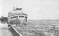
On 21 August 1963, a Soviet twinjet
Tu-124
airliner performed an emergency
water landing
on Neva near the
Finland Railway Bridge
. The plane took off from
Tallinn
-Ulemiste Airport (
TLL
) at 08:55 on 21 August 1963 with 45 passengers and seven crew on board and was scheduled to land at
Moscow
-Vnukovo (
VKO
). After liftoff, the crew noticed that the nose gear undercarriage did not retract, and the
ground control
diverted the flight to
Leningrad
(
LED
) because of
fog
at Tallinn. While circling above St. Petersburg at the altitude of 1,650 feet (500 m), under unclear circumstances (lack of fuel was one of the factors), both engines stalled. The crew performed an emergency landing on the Neva River, barely missing some of its bridges and an 1898-built steam
tugboat
. The tugboat rushed to the plane and towed it to the shore. The plane's pilot was at first fired from his job but was later reinstated and awarded the
Order of the Red Star
.
[45]
[46]
[47]
References
[
edit
]
- ^
a
b
c
Nezhihovsky, R.A. (1981).
Река Нева и Невская губа
[
Neva River and Neva Bay
]. Gidrometeoizdat.
Archived
from the original on 10 April 2023
. Retrieved
25 October
2015
.
- ^
a
b
Kallio, Petri.
"Muinaiskarjalan uralilainen tausta"
.
Academia
.
Archived
from the original on 6 March 2023
. Retrieved
31 December
2018
.
- ^
Wefer, Gerold (2002).
Climate development and history of the North Atlantic realm
. Springer. pp. 217?219.
ISBN
3-540-43201-9
.
Archived
from the original on 10 April 2023
. Retrieved
3 December
2021
.
- ^
Saarnisto, Matti; Gronlund, Tuulikki (1996). "Shoreline displacement of Lake Ladoga ? new data from Kilpolansaari".
Hydrobiologia
.
322
(1?3): 205?215.
doi
:
10.1007/BF00031829
.
S2CID
42459564
.
- ^
Darinskii, A.V. (1982).
География Ленинграда
[
Geography of Leningrad
]. Lenizdat. pp. 12?18.
Archived
from the original on 10 April 2023
. Retrieved
3 December
2021
.
- ^
a
b
c
d
e
f
g
h
i
j
St. Petersburg: Encyclopedia. ? Moscow: Russian Political Encyclopedia. 2006;
ISBN
5-8110-0107-X
- ^
a
b
Darinskii, A.V. (1982).
География Ленинграда
[
Geography of Leningrad
]. Lenizdat. pp. 34?45.
- ^
a
b
c
Ленинград. Историко-географический атлас
[
Leningrad. Historical atlas
]. Moscow: Main Office of Geodesy and Cartography under the
Council of Ministers of the USSR
. 1981. p. 59.
- ^
"Neva, river"
.
Saint Petersburg encyclopaedia
.
Archived
from the original on 26 August 2017
. Retrieved
10 December
2018
.
- ^
a
b
c
Историко-географический атлас "Ленинград"
[Historical atlas "Leningrad"]. Moscow: GUGK CM USSR, 1977
- ^
Leningrad. Historical atlas
. M.: Main Office of Geodesy and Cartography under the
Council of Ministers of the USSR
. 1981. p. 57.
[
permanent dead link
]
- ^
a
b
Atlas of Leningrad Oblast
. GUGK at USSR Council. 1967.
Archived
from the original on 10 April 2023
. Retrieved
3 December
2021
.
- ^
Darinskii, A. V. (1975)
Ленинградская область (Leningrad oblast)
Archived
10 April 2023 at the
Wayback Machine
. Lenizdat, pp. 48?49
- ^
Lihotkin, G. and Milash, N. (1968)
Невский лесопарк
Archived
25 November 2012 at the
Wayback Machine
. (Nevsky Forest Park, in Russian). aroundspb.ru.
- ^
a
b
Все о реке Неве: мосты, притоки, наводнения...
Archived
27 December 2017 at the
Wayback Machine
(All of the Neva River: bridges, tributaries, flooding ..., in Russian). nevariver.ru. Accessed 29 November 2022.
- ^
Holly Hughes, Larry West (2008).
Frommer's 500 Places to See Before They Disappear
. Frommer's. p. 327.
ISBN
978-0-470-18986-3
.
- ^
Ryabchuk, D. V.; et al.
The Neva Bay (Russia) ? antropogenic lagoon
(PDF)
. All-Russia Research Geological Institute.
Archived
(PDF)
from the original on 4 August 2020
. Retrieved
23 June
2010
.
- ^
Water pollution in the hydroelectric power plants area
[
permanent dead link
]
- ^
ПОЛНЫЙ ХРОНОЛОГИЧЕСКИЙ СПИСОК НАВОДНЕНИЙ В САНКТ-ПЕТЕРБУРГЕ (ПЕТРОГРАДЕ, ЛЕНИНГРАДЕ)
Archived
12 February 2012 at the
Wayback Machine
? a list of floods in St. Petersburg (in Russian). nevariver.ru
- ^
Morozova, A. (26 February 2010).
"Из-за паводка в Петербурге могут разобрать мост"
[A bridge might be removed in St. Petersburg because of the flood].
Komsomolskaya Pravda
.
Archived
from the original on 31 March 2018
. Retrieved
23 June
2010
.
- ^
"КАЧЕСТВО ПОВЕРХНОСТНЫХ ВОД РОССИЙСКОЙ ФЕДЕРАЦИИ"
. Archived from
the original
on 19 April 2009
. Retrieved
23 June
2010
.
(quality of surface waters of the Russian Federation). Yearbook 2006. Institute of hydrochemistry, Rostov. ghi.aaanet.ru
- ^
a
b
"Clean Neva"
(in Russian).
Greenpeace
. Archived from
the original
on 10 March 2010
. Retrieved
23 June
2010
.
- ^
"Clean Neva"
(in Russian).
Greenpeace
. Archived from
the original
on 17 March 2010
. Retrieved
23 June
2010
.
- ^
"В ближайшие два года Петербург будет очищать почти 100% сточных вод"
[In the next two years, St. Petersburg will clean almost 100% of wastewater]. RIA Novosti. 20 October 2009.
Archived
from the original on 7 August 2011
. Retrieved
23 June
2010
.
К концу года Петербург будет очищать 91,7% сточных вод, а до 2011 года - почти все 100%, сообщил журналистам руководитель ГУП "Водоканал Петербурга" Феликс Кармазинов.
- ^
Sharymov, Alexander
History of St. Petersburg. 1703. Book studies
Archived
10 April 2023 at the
Wayback Machine
. Journal Neva, 2004;
ISBN
5-87516-044-6
- ^
a
b
c
Ezhov, V. A. (1986)
Ленинградская область: исторический очерк
Archived
10 April 2023 at the
Wayback Machine
. (Leningrad Oblast: a historical sketch, in Russian), Lenizdat.
- ^
Electronic publication of the Institute of Russian Literature (Pushkin House), RAS
Archived
1 February 2019 at the
Wayback Machine
. Lib.pushkinskijdom.ru. Retrieved 13 July 2013.
- ^
The biographical dictionary of the Society for the diffusion of useful knowledge, Volume 1
. Longman, Brown, Green, and Longmans. 1842. p. 855.
Archived
from the original on 10 April 2023
. Retrieved
3 December
2021
.
- ^
Kirby, D. G. (2006).
A concise history of Finland
. Cambridge University Press. p.
8
.
ISBN
0-521-83225-X
.
- ^
В "ПЛЕНУ" У ШВЕДОВ
Archived
27 February 2018 at the
Wayback Machine
. (In "captivity" of the Swedes, in Russian). Sablino.ru.
- ^
Трамвай в Санкт-Петербурге
Archived
24 September 2015 at the
Wayback Machine
. (Tram in St. Petersburg, in Russian). www.opeterburge.ru
- ^
Через Неву по льду
Archived
27 July 2011 at the
Wayback Machine
. (Over Neva on ice, in Russian). livejournal.com
- ^
За три копейки через Неву
Archived
1 September 2011 at the
Wayback Machine
. (For 3 kopeks over Neva, in Russian),
Vechernii St. Petersburg
(5 February 2010).
- ^
Shapilov, E., ed. (1994).
From horsecar to tram: History of transport in St. Petersburg
(in Russian).
ISBN
5-87417-002-2
.
Archived
from the original on 10 April 2023
. Retrieved
3 December
2021
.
- ^
Antonov, B.I. "Bridges of St. petersburg", Glagol, 2002.
- ^
Russian river fleet and tourism INFOFLOT.RU
Archived
20 October 2017 at the
Wayback Machine
. Map.infoflot.ru. Retrieved on 2013-07-13.
- ^
"Водный транспорт"
. Archived from
the original
on 30 March 2009
. Retrieved
23 June
2010
.
. www.st-petersburg.ru (in Russian).
- ^
Transneft has finished laying a tunnel under the Neva
Archived
24 July 2011 at the
Wayback Machine
. Vsluh.ru (25 August 2008). Retrieved on 2013-07-13.
- ^
"Под Невой проложен тоннель для "Северного потока"
"
. Archived from
the original
on 21 January 2010
. Retrieved
23 June
2010
.
. energospace.ru (22 July 2009).
- ^
Технологии очистки
Archived
23 July 2013 at the
Wayback Machine
. vodokanal.spb.ru (in Russian).
- ^
Ново-Адмиралтейский мост через Неву
Archived
30 November 2010 at the
Wayback Machine
. (Novo Admiralty-bridge across the Neva, in Russian) Spb-projects.ru.
- ^
a
b
Староладожский и Новоладожский каналы
Archived
15 December 2009 at the
Wayback Machine
. infoflot.ru (in Russian)
- ^
Ethnographic and open-air museums
Archived
28 September 2018 at the
Wayback Machine
, UNESCO, pp. 170?173
- ^
Church of the Intercession
Archived
30 January 2011 at the
Wayback Machine
. Bogoslovka.ru (in Russian). Retrieved on 2013-07-13.
- ^
"A320 splashed on the Hudson, as the Tu-124 on the Neva River in 1963"
. AviaPort.
Archived
from the original on 29 September 2011
. Retrieved
23 June
2010
.
- ^
"Accident description"
. Aviation Safety Network.
Archived
from the original on 11 January 2012
. Retrieved
23 June
2010
.
- ^
"The plane could land on the city but landed... on Neva"
. Petrovsky Courier, No 41 (211). 2 November 1998.
Archived
from the original on 27 April 2012
. Retrieved
23 June
2010
.
External links
[
edit
]
Wikimedia Commons has media related to
Neva River
.