City in California, United States
City in California, United States
Needles
is a city in eastern
San Bernardino County, California
, in the
Mojave Desert
region of
Southern California
. Situated on the western banks of the
Colorado River
, Needles is located near the California border with
Arizona
and
Nevada
.
[6]
The city is accessible via
Interstate 40
and
U.S. Route 95
. The population was 4,959 at the
2020 census
, up from 4,844 at the
2010 census
.
History
[
edit
]
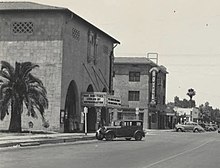 Downtown Needles, c. 1930s.
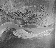 Aerial view of Needles, 1930s
 AT&SF
rail yards in Needles, 1942
AT&SF
rail yards in Needles, 1942
Mojave Indians
first inhabited the area.
[7]
Needles was founded in May 1883 during the construction of the
Atchison, Topeka and Santa Fe Railway
,
[8]
which originally crossed the
Colorado River
at
Eastbridge, Arizona
three miles southeast of modern Needles. Needles was named after
"The Needles"
, a group of
pinnacles
in the
Mohave Mountains
on the Arizona side of the river. The crossing was a poor site for a bridge, lacking firm banks and a solid bottom.
[9]
: 82
A bridge was built, but it was of poor quality. Not only was it a "flimsy looking structure", but it was an obstacle to navigation on the river. Flooding on the Colorado River destroyed the bridge three times ? in 1884, 1886 and 1888. The railway built
Red Rock Bridge
, a high
cantilever bridge
, at a narrower point with solid rock footings, ten miles downstream near today's
Topock
. The bridge was completed in May 1890, and the old bridge was dismantled.
[9]
: 82
At first it was a tent town for railroad construction crews, but the railway would eventually build a hotel, car sheds, shops and a roundhouse. Within only a month, Needles would have a Chinese laundry, a newsstand, a restaurant, several general stores, and nine or ten saloons. Needles quickly became the largest port on the river above
Yuma, Arizona
.
[9]
: 82
The railway and the
Fred Harvey Company
built the elegant
Neoclassical
and
Beaux-Arts
style
El Garces Hotel
and Santa Fe Station in 1908, which was considered the "crown jewel" of the entire Fred Harvey chain.
[8]
The landmark building is on the
National Register of Historic Places
and is being restored.
Needles was a major stop on the historic
U.S. Route 66
highway from the 1920s through the 1960s.
[10]
For migrants from the Midwest
Dust Bowl
in the 1930s, it was the town that marked their arrival in California. The city is lined with
motels
and other shops from that era. The "Carty's Camp", which appears briefly in
The Grapes of Wrath
as the Joad family enters California from
Arizona
,
[8]
is now a ghost tourist court, its remains located behind the 1940s-era
66 Motel
.
In 1949, the
United States Bureau of Reclamation
began an extensive project to dredge a new channel for the Colorado River that would straighten out a river bend that caused serious silt problems after the Hoover Dam was completed.
[11]
Needles is a tourism and recreation center.
[8]
The city is the eastern gateway to the
Mojave National Preserve
, a scenic desert area.
Geography
[
edit
]
Climate
[
edit
]
 The
Colorado River
separates Needles, in California, from
Mohave Valley
, in
Arizona
.
The
Colorado River
separates Needles, in California, from
Mohave Valley
, in
Arizona
.
The city has a
desert climate
with a
subtropical
temperature range, with a mean annual temperature of 74.2 °F (23.4 °C).
[12]
Needles, like
Death Valley
to the northwest, is known for extreme heat during the summer. The Needles weather station is frequently reported by the United States government's
National Oceanic and Atmospheric Administration
(NOAA) as the site of the highest daily temperature recorded in the U.S. during the desert summers. Needles occasionally sets national or world daily temperature records, along with other related records associated with extreme desert heat. For instance, on July 22, 2006, Needles experienced a record high low temperature of 100 °F (38 °C) at 6:00 am with a high temperature exceeding 120 °F (49 °C),
[13]
making it one of the few locations on Earth that have recorded an overnight minimum temperature higher than 100 °F (37.8 °C).
On August 13, 2012, Needles experienced a thunderstorm that deposited rain at a temperature of 115 °F (46 °C) starting at 3:56 pm, setting a new record for the hottest rain in world history. The air temperature was 118 °F (48 °C), tying Needles's record high for the date. Since the humidity was only 11%, the rain evaporated so that "only a trace of precipitation was recorded in the rain gauge". Weather records researcher Maximiliano Herrera reported that this was the lowest humidity at which rain has occurred on Earth in recorded history.
[14]
On May 4, 2014, Needles reached a temperature of 102 °F (39 °C) with a
dewpoint
of ?38 °F (?39 °C), for a
relative humidity
of 0.33%, the lowest value ever recorded on Earth.
[15]
In the winter, temperatures are typically mild, with December, the coolest month, having a normal mean temperature of 54.7 °F (12.6 °C). The hottest month, July, has a normal mean temperature of 98.5 °F (36.9 °C).
[16]
On average, there are 119 days annually with a maximum of 100 °F (37.8 °C) or higher, 175 days with a maximum of 90 °F (32 °C) or higher, and 2.7 days with a minimum of 32 °F (0 °C) or lower.
[17]
Official record temperatures range from 18 °F (?8 °C) on January 22, 1937, to 125 °F (52 °C), last recorded on June 20, 2017.
[16]
[18]
Annual normal rainfall is 4.32 in (110 mm), and there is an annual normal of 23 days with measurable precipitation.
[17]
The wettest year was 1939 with 13.33 in (339 mm) of rainfall and the driest year was 2006 with 0.70 in (18 mm). The most rainfall in one month was 7.61 in (193 mm) in September 1939.
[16]
The most rainfall in a calendar day was 3.49 in (89 mm) on August 19, 1906.
[16]
Snowfall is very rare in Needles, with the only month recording measurable snowfall being January 1949, when 15.2 in (38.6 cm) of snow fell, including 12.2 in (31.0 cm) inches on January 12, 1949.
[16]
[12]
The city is also known for moderate to locally severe thunderstorms during the
monsoon
season as well as humid conditions.
Needles is served by the
National Weather Service
's NOAA Weather Radio operating on 162.50 MHz from the Las Vegas National Weather Service.
| Climate data for
Needles Airport
, California (1991–2020 normals,
[a]
extremes 1888–present)
|
| Month
|
Jan
|
Feb
|
Mar
|
Apr
|
May
|
Jun
|
Jul
|
Aug
|
Sep
|
Oct
|
Nov
|
Dec
|
Year
|
| Record high °F (°C)
|
85
(29)
|
92
(33)
|
99
(37)
|
107
(42)
|
118
(48)
|
125
(52)
|
125
(52)
|
123
(51)
|
120
(49)
|
112
(44)
|
92
(33)
|
83
(28)
|
125
(52)
|
| Mean maximum °F (°C)
|
75.4
(24.1)
|
80.7
(27.1)
|
91.3
(32.9)
|
100.8
(38.2)
|
108.0
(42.2)
|
115.6
(46.4)
|
118.4
(48.0)
|
116.7
(47.1)
|
111.5
(44.2)
|
101.3
(38.5)
|
87.4
(30.8)
|
74.6
(23.7)
|
119.6
(48.7)
|
| Mean daily maximum °F (°C)
|
66.4
(19.1)
|
71.0
(21.7)
|
79.1
(26.2)
|
86.6
(30.3)
|
96.2
(35.7)
|
106.4
(41.3)
|
110.5
(43.6)
|
109.3
(42.9)
|
102.6
(39.2)
|
89.5
(31.9)
|
75.1
(23.9)
|
64.5
(18.1)
|
88.1
(31.2)
|
| Daily mean °F (°C)
|
56.2
(13.4)
|
59.9
(15.5)
|
66.6
(19.2)
|
73.7
(23.2)
|
83.1
(28.4)
|
93.0
(33.9)
|
98.5
(36.9)
|
97.4
(36.3)
|
90.0
(32.2)
|
77.0
(25.0)
|
63.8
(17.7)
|
54.7
(12.6)
|
76.2
(24.6)
|
| Mean daily minimum °F (°C)
|
46.0
(7.8)
|
48.8
(9.3)
|
54.1
(12.3)
|
60.8
(16.0)
|
70.0
(21.1)
|
79.6
(26.4)
|
86.6
(30.3)
|
85.4
(29.7)
|
77.3
(25.2)
|
64.6
(18.1)
|
52.5
(11.4)
|
45.0
(7.2)
|
64.2
(17.9)
|
| Mean minimum °F (°C)
|
34.0
(1.1)
|
37.1
(2.8)
|
41.9
(5.5)
|
48.6
(9.2)
|
56.5
(13.6)
|
66.2
(19.0)
|
75.6
(24.2)
|
74.9
(23.8)
|
65.0
(18.3)
|
51.5
(10.8)
|
39.7
(4.3)
|
33.4
(0.8)
|
31.8
(?0.1)
|
| Record low °F (°C)
|
18
(?8)
|
22
(?6)
|
29
(?2)
|
33
(1)
|
39
(4)
|
46
(8)
|
57
(14)
|
60
(16)
|
40
(4)
|
34
(1)
|
25
(?4)
|
20
(?7)
|
18
(?8)
|
| Average
precipitation
inches (mm)
|
0.73
(19)
|
0.79
(20)
|
0.51
(13)
|
0.18
(4.6)
|
0.07
(1.8)
|
0.04
(1.0)
|
0.27
(6.9)
|
0.39
(9.9)
|
0.34
(8.6)
|
0.22
(5.6)
|
0.34
(8.6)
|
0.44
(11)
|
4.32
(110)
|
| Average precipitation days
(≥ 0.01 in)
|
3.3
|
3.7
|
2.9
|
1.3
|
0.7
|
0.3
|
1.8
|
1.9
|
1.8
|
1.6
|
1.5
|
2.3
|
23.1
|
| Mean monthly
sunshine hours
|
248
|
254.3
|
310
|
360
|
403
|
420
|
403
|
372
|
330
|
310
|
240
|
248
|
3,898.3
|
| Mean daily
sunshine hours
|
8
|
9
|
10
|
12
|
13
|
14
|
13
|
12
|
11
|
10
|
8
|
8
|
11
|
| Percent
possible sunshine
|
79
|
82
|
83
|
92
|
93
|
97
|
92
|
90
|
89
|
88
|
78
|
81
|
87
|
| Average
ultraviolet index
|
3
|
4
|
6
|
8
|
9
|
10
|
11
|
10
|
8
|
5
|
4
|
2
|
7
|
| Source 1: NOAA
[16]
[17]
WRCC
[19]
|
| Source 2: Weather Atlas (sun and uv)
[20]
|
Demographics
[
edit
]
Historical population
| Census
| Pop.
| Note
| %±
|
|---|
| 1920
| 2,807
| | ?
|
|---|
| 1930
| 3,144
| | 12.0%
|
|---|
| 1940
| 3,624
| | 15.3%
|
|---|
| 1950
| 4,051
| | 11.8%
|
|---|
| 1960
| 4,590
| | 13.3%
|
|---|
| 1970
| 4,051
| | ?11.7%
|
|---|
| 1980
| 4,120
| | 1.7%
|
|---|
| 1990
| 5,191
| | 26.0%
|
|---|
| 2000
| 4,830
| | ?7.0%
|
|---|
| 2010
| 4,844
| | 0.3%
|
|---|
| 2019 (est.)
| 4,976
| [5]
| 2.7%
|
|---|
|
2000
[
edit
]
As of the
census
[22]
of 2000, there were 4,830 people, 1,940 households, and 1,268 families residing in the city. The estimated population in July 2006: 5,330 (+10.4% change).
[23]
The population density was 162.3 inhabitants per square mile (62.7/km
2
). There were 2,551 housing units at an average density of 85.7 per square mile (33.1/km
2
). The racial makeup of the city was 77.9%
White
, 1.6%
African American
, 7.0%
Native American
, 1.4%
Asian
, 0.1%
Pacific Islander
, 6.4% from
other races
, and 5.6% from two or more races.
Hispanic
or
Latino
of any race were 18.4% of the population.
There were 1,940 households, out of which 31.2% had children under the age of 18 living with them, 42.5% were
married couples
living together, 16.8% had a female householder with no husband present, and 34.6% were non-families. 29.0% of all households were made up of individuals, and 13.1% had someone living alone who was 65 years of age or older. The average household size was 2.5 and the average family size was 3.0.
In the city, the population was spread out, with 27.6% under the age of 18, 7.5% from 18 to 24, 23.6% from 25 to 44, 25.6% from 45 to 64, and 15.7% who were 65 years of age or older. The median age was 39 years. For every 100 females, there were 96.7 males. For every 100 females age 18 and over, there were 92.2 males.
The median income for a household in the city was $26,108, and the median income for a family was $33,264. Males had a median income of $39,688 versus $19,483 for females. The
per capita income
for the city was $15,156. About 21.2% of families and 26.1% of the population were below the
poverty line
, including 38.2% of those under age 18 and 11.3% of those age 65 or over.
Major employment in the city is supported by the
BNSF Railway
(formerly the
Santa Fe Railroad
). The depot has been a terminal (crew change point) for the railway since the late 19th century. The railroad company has been the city's main employment source for over a century.
According to the
United States Census Bureau
, the city has a total area of 30.2 square miles (78 km
2
). 29.8 square miles (77 km
2
) of it is land and 0.4 square miles (1.0 km
2
) of it (1.36%) is water.
The once smaller nearby communities of
Bullhead City, Arizona
,
Lake Havasu City, Arizona
, and
Laughlin, Nevada
have in recent years become larger communities than Needles.
2010
[
edit
]
 The Pirate Cove Resort.
The
2010 United States Census
[24]
reported that Needles had a population of 4,844. The population density was 154.9 inhabitants per square mile (59.8/km
2
). The racial makeup of Needles was 3,669 (75.7%)
White
(65.4% Non-Hispanic White),
[25]
95 (2.0%)
African American
, 399 (8.2%)
Native American
, 35 (0.7%)
Asian
, 9 (0.2%)
Pacific Islander
, 323 (6.7%) from
other races
, and 314 (6.5%) from two or more races.
Hispanic
or
Latino
of any race were 1,083 persons (22.4%).
The Census reported that 4,839 people (99.9% of the population) lived in households, 5 (0.1%) lived in non-institutionalized group quarters, and 0 (0%) were institutionalized.
There were 1,918 households, out of which 650 (33.9%) had children under the age of 18 living in them, 712 (37.1%) were
opposite-sex married couples
living together, 331 (17.3%) had a female householder with no husband present, 159 (8.3%) had a male householder with no wife present. There were 186 (9.7%)
unmarried opposite-sex partnerships
, and 6 (0.3%)
same-sex married couples or partnerships
. 588 households (30.7%) were made up of individuals, and 238 (12.4%) had someone living alone who was 65 years of age or older. The average household size was 2.52. There were 1,202
families
(62.7% of all households); the average family size was 3.12.
The population was spread out, with 1,283 people (26.5%) under the age of 18, 401 people (8.3%) aged 18 to 24, 1,038 people (21.4%) aged 25 to 44, 1,357 people (28.0%) aged 45 to 64, and 765 people (15.8%) who were 65 years of age or older. The median age was 39.3 years. For every 100 females, there were 101.6 males. For every 100 females age 18 and over, there were 95.0 males.
There were 2,895 housing units at an average density of 92.6 per square mile (35.8/km
2
), of which 1,015 (52.9%) were owner-occupied, and 903 (47.1%) were occupied by renters. The homeowner vacancy rate was 4.9%; the rental vacancy rate was 17.2%. 2,578 people (53.2% of the population) lived in owner-occupied housing units and 2,261 people (46.7%) lived in rental housing units.
According to the 2010 United States Census, Needles had a median household income of $29,613, with 28.8% of the population living below the poverty line.
[26]
Government
[
edit
]
 Broadway Street.
The City of Needles was incorporated on October 30, 1913.
[2]
It is a charter city, led by an elected mayor and a city council with six elected members. Mayors serve two-year terms of office, and councilmembers serve four-year terms. The council designates a vice mayor from among its members.
[27]
The city council also appoints a city manager who is responsible for the operation of city departments. As of October 2023, the current city manager is Patrick J. Martinez.
[28]
State and federal representation
[
edit
]
In the
California State Legislature
, Needles is in
the 16th Senate District
, represented by
Democrat
Melissa Hurtado
, and in
the 33rd Assembly District
, represented by
Republican
Devon Mathis
.
[29]
In the
United States House of Representatives
, Needles is in
California's 25th congressional district
, represented by
Democrat
Raul Ruiz
.
[30]
Proposals for secession
[
edit
]
In 2008, claiming the county had been unwilling to help keep the city's troubled hospital open as a full-service medical facility, the city considered seceding from California and becoming part of neighboring
Nevada
, only a few miles away. The options of attaching itself to the state of
Arizona
or even forming a new county were also considered.
[31]
Proposals to change states would require approval from the
United States Congress
and both state legislatures.
Education
[
edit
]
Needles' elementary schools and
Needles High School
are part of the
Needles Unified School District
. The school district is one of the largest in the United States in terms of area with almost 6,000 square miles (16,000 km
2
) in its boundaries. The district runs from Amboy to Needles, and south to Parker Dam. It has 1,158 students enrolled.
[32]
The local Needles schools include Katie Hohstadt Elementary School, formerly called 'D' Street School (new home of Needles Head Start, and no longer a regular public school), Vista Colorado Elementary School (grades K?5), Needles Middle School (grades 6?8), Needles High School (grades 9?12), and the Educational Training Center (grades 9?12). Needles High School, due to its distance from other California schools, is a member of the
Nevada Interscholastic Activities Association
, along with four other similarly placed California schools:
Truckee
, North Tahoe, South Tahoe, and
Coleville
.
Needles also has two private schools: the Needles Assembly of God Christian School and the Needles Seventh-day Adventist School.
Infrastructure
[
edit
]
 El Garces Transportation Center
.
El Garces Transportation Center
.
Transportation
[
edit
]
Interstate 40
, known locally as the Needles Freeway, is the major highway through Needles, connecting
Barstow
to the west and
Arizona
to the east.
U.S. Route 95
also enters the city from the east on former Route 66 as a
concurrency
with the I-40 freeway, then splits with the Interstate west of the city, and heads north to
Nevada
. The Colorado River Bridge connects Needles directly with
Mohave County, Arizona
, and
Arizona State Route 95
.
Amtrak
, the national passenger rail system, provides daily service to
Needles station
, operating its
Southwest Chief
between
Chicago
and
Los Angeles
. It arrives between midnight and 2 am.
Local transit service to the Needles area is provided by
Needles Area Transit
.
[33]
As of August 2, 2016,
Victor Valley Transit Authority
has service from Needles to Barstow and Victorville on Fridays. To Barstow and Victorville, the bus leaves at 6:15 and arrives at Victorville at 10:30 am. On the reverse trip, buses leave Victorville at 2:30 pm and arrives at Barstow at 7:15 pm.
Vegas Airporter provides service between
Lake Havasu City
, Needles, and
Harry Reid International Airport
in
Las Vegas
.
[34]
Public safety
[
edit
]
On July 1, 2016,
San Bernardino County Fire Department
annexed the City of Needles.
[35]
Fire Station 32 provides fire protection to the City of Needles and houses two Type 1 Engine companies, one Type 7 Engine company, one Water Tender and one 28 foot fireboat. The station is staffed full-time with career firefighters.
Since December 1989 the City of Needles has been patrolled by the
San Bernardino County Sheriff's Department
under the command of Captain Ross Tarangle from the Needles Patrol Station.
[36]
Health
[
edit
]
Colorado Medical Center was once a full service hospital but at present it's functioning as an
urgent care center
.
[37]
Notable people
[
edit
]
- Pat Morris
, Mayor of
San Bernardino, California
.
[38]
- Max Rafferty
, Needles Superintendent of Schools, 1955?1961,
[39]
became California
Superintendent of Public Instruction
1962?1970.
- Charles Schulz
, cartoonist of
Peanuts
, lived in Needles 1928?30 and made it the residence of
Snoopy
's brother
Spike
.
[8]
- Bess Houdini
, wife and stage assistant of famed escape artist
Harry Houdini
, died in Needles in 1943.
[8]
- Yara tav
, leader of the
Mohave people
(1861?1874), born close to the Needles rock formation before the establishment of the town.
[40]
- Alice Notley
, American poet, grew up in Needles.
[41]
- Natalie Diaz
American poet and winner of the 2021 Pulitzer Prize for Poetry.
[42]
- Sam Kinison
, American stand-up comedian, was killed in a car crash caused by 17-year-old drunk driver Troy Pierson, about 4.3 miles (6.9 kilometers) outside of Needles on April 10, 1992.
[43]
[44]
In popular culture
[
edit
]
Books
[
edit
]
Print
[
edit
]
- In the comic strip
Peanuts
Snoopy's brother
Spike
lived in the desert outside Needles.
[8]
He frequently heads to Needles to partake of the town's nightlife, often running afoul of the local coyotes.
Recordings
[
edit
]
- In 2004,
John Lowery
(John 5), former guitarist for Marilyn Manson, released his CD
Vertigo
, in which the first track is entitled "Needles CA".
- The town is mentioned in the lyrics of
Hoyt Axton
's "
Never Been to Spain
"; the song was a hit for
Three Dog Night
in 1972 and was also performed by Elvis and Waylon Jennings:
Well I never been to England, but I kinda like the Beatles. Well, I headed for Las Vegas, only made it out to Needles. Can you feel it? Must be real. It feels so good!
- Izzy Stradlin
's 1999 album
Ride On
includes a track entitled "Needles" about his love of visiting the town.
- In 2009 the song "Don't Look Down" by Barnaby Bright includes the following:
We pulled into a truck stop Somewhere just outside of Needles, California, You asked me for ten bucks and I said "What about the last ten bucks I loaned you?"
Television
[
edit
]
- In October 2006, two students and two teachers from Needles High School were invited to Washington, D.C. to meet with the Under Secretary of Defense, in which they spoke of the new program at Needles High School called MOCK National Security Workshop. The students were also interviewed for the nationwide, fifteen-minute television news show,
Channel One News
; the episode was aired on October 25.
- Needles was the main site of a 2009
UFO Hunters
episode investigating a supposed
UFO
Crash.
- Needles High School
was on a
School Pride
television episode on November 12, 2010.
Other connections
[
edit
]
- In late 2000 to early 2001, skateboarder
Tony Hawk
donated $20,000 to the Needles Skate Park, which is still in use today
[update]
. Hawk was present for the grand opening of the park in January 2004.
[46]
[47]
- Needles (and the surrounding area) was the scene for the hit 1988
post-apocalyptic
computer
RPG
Wasteland
.
- Murals were painted of U.S. 66, which passed through Needles on its way between
Chicago
and
Los Angeles
.
[48]
References
[
edit
]
- ^
Mean monthly maxima and minima (i.e. the highest and lowest temperature readings during an entire month or year) calculated based on data at said location from 1991 to 2020.
- ^
a
b
"Needles"
.
Geographic Names Information System
.
United States Geological Survey
,
United States Department of the Interior
. Retrieved
November 12,
2014
.
- ^
a
b
"California Cities by Incorporation Date"
. California Association of
Local Agency Formation Commissions
. Archived from
the original
(Word)
on November 3, 2014
. Retrieved
August 25,
2014
.
- ^
"2019 U.S. Gazetteer Files"
. United States Census Bureau
. Retrieved
July 1,
2020
.
- ^
"Explore Census Data"
.
- ^
a
b
"Population and Housing Unit Estimates"
. United States Census Bureau. May 24, 2020
. Retrieved
May 27,
2020
.
- ^
"City of Needles Economic Development Strategic Plan"
(PDF)
. April 22, 2014. Archived from
the original
(PDF)
on June 10, 2017
. Retrieved
August 16,
2017
.
- ^
"Needles History by Maggie McShan"
. City Of Needles
. Retrieved
November 14,
2023
.
- ^
a
b
c
d
e
f
g
h
Beyer, John R. (January 19, 2020).
"Needles, a small town with a big history"
. Beyer's Byways.
Daily Press
. Victorville, Calif
. Retrieved
January 19,
2020
.
- ^
a
b
c
Richard E. Lingenfelter, Steamboats on the Colorado River, 1852?1916, University of Arizona Press, Tucson, 1978
Archived
January 18, 2016, at the
Wayback Machine
- ^
Fry, Hannah (August 1, 2019).
"This California town wants to be a 2nd Amendment 'sanctuary city' for guns and ammo"
.
Los Angeles Times
. Retrieved
August 1,
2019
.
- ^
"Putting A River In Its Place"
Popular Mechanics
, July 1949
- ^
a
b
"Needles FAA Airport, California ? Climate Summary"
. wrcc.dri.edu
. Retrieved
January 5,
2012
.
- ^
"Needles FAA Airport, California ? Daily Summary"
. wunderground.com. July 22, 2006
. Retrieved
January 5,
2012
.
- ^
Masters, Jeff
(August 15, 2012).
"Hottest rain on record? Rain falls at 115°F in Needles, California"
.
- ^
Jeff Masters (June 22, 2017).
"A World Record Low Humidity? 116°F With a 0.36% Humidity in Iran"
.
Weather Underground
. Retrieved
January 10,
2019
.
- ^
a
b
c
d
e
f
"NowData ? NOAA Online Weather Data"
.
National Oceanic and Atmospheric Administration
. Retrieved
July 18,
2020
.
- ^
a
b
c
"Summary of Monthly Normals 1991-2020"
. National Oceanic and Atmospheric Administration
. Retrieved
September 8,
2022
.
- ^
"Summary of Great Southwest US Heat Wave of 2017"
. Retrieved
July 19,
2012
.
- ^
WRCC.
"Western U.S. Climate Historical Summaries Weather"
. Desert Research Institute
. Retrieved
July 2,
2011
.
- ^
"Monthly weather forecast and climate - Needles, CA"
. Weather Atlas
. Retrieved
March 29,
2020
.
- ^
"Census of Population and Housing"
. Census.gov
. Retrieved
June 4,
2015
.
- ^
"U.S. Census website"
.
United States Census Bureau
. Retrieved
January 31,
2008
.
- ^
"Needles, California (CA) Detailed Profile ? relocation, real estate, travel, jobs, hospitals, schools, crime, news, sex offenders"
. City-data.com
. Retrieved
January 5,
2012
.
- ^
"2010 Census Interactive Population Search: CA ? Needles city"
. U.S. Census Bureau. Archived from
the original
on July 15, 2014
. Retrieved
July 12,
2014
.
- ^
"U.S. Census website"
.
United States Census Bureau
. Retrieved
March 11,
2015
.
- ^
"U.S. Census website"
.
- ^
"City CounciI"
. City of Needles. Archived from
the original
on January 28, 2015
. Retrieved
January 24,
2015
.
- ^
"City Manager's Office - CITY OF NEEDLES, CALIFORNIA (Official Municipality Site)"
.
City of Needles
. Retrieved
January 19,
2020
.
- ^
"Statewide Database"
. UC Regents. Archived from
the original
on February 1, 2015
. Retrieved
November 30,
2014
.
- ^
"California's 25th Congressional District - Representatives & District Map"
. Civic Impulse, LLC.
- ^
Kelly, David (May 26, 2008).
"Regretting its place in the sun"
.
Los Angeles Times
.
Archived
from the original on August 10, 2021
. Retrieved
April 19,
2023
.
- ^
"Needles Unified School District schools, Needles, CA: charter and public schools. Needles school district"
. Greatschools.net. September 7, 2010
. Retrieved
January 5,
2012
.
- ^
"SANBAG: Public Transit"
. Sanbag.ca.gov. July 5, 2011. Archived from
the original
on November 6, 2011
. Retrieved
January 5,
2012
.
- ^
"Pickup & Drop-off Locations ? VegasAirporter.com"
. Retrieved
February 6,
2021
.
- ^
"San Bernardino County Fire Department"
. Sbcfire.org. Archived from
the original
on May 12, 2020
. Retrieved
November 14,
2019
.
- ^
"San Bernardino County Sheriff's Department"
. wp.sbcounty.gov/sheriff/
. Retrieved
November 14,
2019
.
- ^
"City of Needles"
. City of Needles. June 28, 2002. Archived from
the original
on January 2, 2012
. Retrieved
January 5,
2012
.
- ^
"City of San Bernardino ? Mayor's Biography"
. Ci.san-bernardino.ca.us. Archived from
the original
on January 17, 2012
. Retrieved
January 5,
2012
.
- ^
"Max Rafferty, 1917?1982, Conservative U.S. Educator and Critic: Bibliography of Writings By and About Him," CORE (Collected Original Resources in Education), VII, No. 1 (1983), Fiche 9 C1
- ^
Kroeber, Alfred Louis
(1925).
Handbook of the Indians of California
. Courier. pp. 725?727.
ISBN
978-0-486-23368-0
.
- ^
"Poets.org"
. August 10, 2001.
- ^
"Pulitzer Prize-Winning Poet Natalie Diaz to give Public Poetry Reading"
.
University of Illinois Office of the Vice Chancellor for DIVERSITY, EQUITY & INCLUSION
. Retrieved
October 3,
2022
.
Diaz was born and raised in the Fort Mojave Indian Village in Needles, California, on the banks of the Colorado River.
- ^
"Motorist, 17, Arrested In Death Of Sam Kinison"
.
The Seattle Times
. April 12, 1992
. Retrieved
April 16,
2023
.
- ^
Lambert, Bruce (April 12, 1992).
"Sam Kinison, 38, Comedian, Dies; Wife Injured in Head-On Collision"
.
The New York Times
. Retrieved
April 16,
2023
.
- ^
Gardens in the Dunes
- ^
"Needles Skate Park"
. City of Needles.
Archived
from the original on December 1, 2021
. Retrieved
January 23,
2022
.
- ^
Choquette, Lee (January 3, 2004).
"Skateboard set cheers as Needles Skate Park opens"
.
Mohave Valley Daily News
. Retrieved
January 23,
2022
.
- ^
"A touch of paint cheers a desert town"
.
Los Angeles Times
. August 30, 2011
. Retrieved
January 5,
2012
.
External links
[
edit
]
|
|---|
| Counties
| |
|---|
| Principal cities
| |
|---|
Cities and towns
100k+
| |
|---|
Cities and towns
25k?100k
| |
|---|
Cities and towns
10k?25k
| |
|---|
Cities and towns
under 10k
| |
|---|
| Regions
| |
|---|
|
|---|
| International
| |
|---|
| National
| |
|---|
| Geographic
| |
|---|