From Wikipedia, the free encyclopedia
 Location of Wayne County in Kentucky
This is a list of the
National Register of Historic Places listings in Wayne County, Kentucky
.
It is intended to be a complete list of the properties on the
National Register of Historic Places
in
Wayne County
,
Kentucky
,
United States
. The locations of National Register properties for which the latitude and longitude coordinates are included below, may be seen in a map.
[1]
There are 8 properties listed on the National Register in the county, 1 of which is a
National Historic Landmark
.
This
National Park Service
list is complete through
NPS recent listings
posted June 14, 2024.
[2]
Contents:
Counties in Kentucky
Current listings
[
edit
]
| [3]
|
Name on the Register
|
Image
|
Date listed
[4]
|
Location
| City or town
|
Description
|
| 1
|
Adkins-Hurt Mill
|
Upload image
|
May 6, 1977
(
#77000662
)
|
Off
Kentucky Route 167
36°39′06″N
84°48′16″W
/
36.651667°N 84.804444°W
/
36.651667; -84.804444
(
Adkins-Hurt Mill
)
| Mount Pisgah
|
|
| 2
|
Battle of Mill Springs Historic Areas
|
 Battle of Mill Springs Historic Areas Battle of Mill Springs Historic Areas
|
February 18, 1993
(
#93000001
)
|
Three discontiguous areas: one south of Nancy, one in Mill Springs, and one to the north across the
Cumberland River
36°55′29″N
84°46′47″W
/
36.924722°N 84.779722°W
/
36.924722; -84.779722
(
Battle of Mill Springs Historic Areas
)
| Mill Springs
|
|
| 3
|
Fairchild House
|
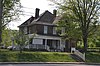 Fairchild House Fairchild House
|
March 25, 2008
(
#08000215
)
|
302 S. Main St.
36°49′33″N
84°51′09″W
/
36.825833°N 84.8525°W
/
36.825833; -84.8525
(
Fairchild House
)
| Monticello
|
|
| 4
|
Hotel Breeding
|
 Hotel Breeding Hotel Breeding
|
August 25, 1988
(
#88001315
)
|
201-211 N. Main St.
36°49′50″N
84°50′55″W
/
36.830556°N 84.848611°W
/
36.830556; -84.848611
(
Hotel Breeding
)
| Monticello
|
|
| 5
|
Mill Springs Mill
|
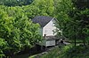 Mill Springs Mill Mill Springs Mill
|
April 11, 1973
(
#73000858
)
|
Off
Kentucky Route 90
36°56′03″N
84°46′44″W
/
36.934167°N 84.778889°W
/
36.934167; -84.778889
(
Mill Springs Mill
)
| Mill Springs
|
|
| 6
|
Monticello Historic Commercial District
|
Upload image
|
October 29, 1982
(
#82001577
)
|
Main and Columbia Sts.
36°49′46″N
84°50′57″W
/
36.829444°N 84.849167°W
/
36.829444; -84.849167
(
Monticello Historic Commercial District
)
| Monticello
|
Historic district with 11
contributing buildings
.
|
| 7
|
Wayne County High School
|
 Wayne County High School Wayne County High School
|
July 30, 2013
(
#13000567
)
|
80 A.J. Lloyd Cir.
36°49′28″N
84°51′41″W
/
36.824556°N 84.861425°W
/
36.824556; -84.861425
(
Wayne County High School
)
| Monticello
|
|
| 8
|
West-Metcalfe House
|
Upload image
|
November 17, 1977
(
#77000661
)
|
1.75 miles south of Mill Springs off
Kentucky Route 90
36°55′10″N
84°46′39″W
/
36.919444°N 84.7775°W
/
36.919444; -84.7775
(
West-Metcalfe House
)
| Mill Springs
|
|
See also
[
edit
]
References
[
edit
]
- ^
The latitude and longitude information provided in this table was derived originally from the National Register Information System, which has been found to be fairly accurate for about 99% of listings. Some locations in this table may have been corrected to current GPS standards.
- ^
National Park Service,
United States Department of the Interior
,
"National Register of Historic Places: Weekly List Actions"
, retrieved June 14, 2024.
- ^
Numbers represent an alphabetical ordering by significant words. Various colorings, defined
here
, differentiate
National Historic Landmarks
and
historic districts
from other NRHP buildings, structures, sites or objects.
- ^
The eight-digit number below each date is the number assigned to each location in the
National Register Information System
database, which can be viewed by clicking the number.
|
|---|
| Topics
| |
|---|
| Lists by state
| |
|---|
| Lists by insular areas
| |
|---|
| Lists by associated state
| |
|---|
| Other areas
| |
|---|
| Related
| |
|---|
|
