From Wikipedia, the free encyclopedia
 Location of Ripley County in Missouri
This is a list of the
National Register of Historic Places listings in Ripley County, Missouri
.
This is intended to be a complete list of the properties and districts on the
National Register of Historic Places
in
Ripley County
,
Missouri
,
United States
. Latitude and longitude coordinates are provided for many National Register properties and districts; these locations may be seen together in a map.
[1]
There are 9 properties and districts listed on the National Register in the county.
This
National Park Service
list is complete through
NPS recent listings
posted June 14, 2024.
[2]
Current listings
[
edit
]
| [3]
|
Name on the Register
|
Image
|
Date listed
[4]
|
Location
| City or town
|
Description
|
| 1
|
B-9 Structure Archeological Site
|
Upload image
|
October 7, 1975
(
#75001072
)
|
Address Restricted
| Grandin
|
|
| 2
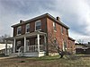
|
Randolph Columbus Barrett House
|
 Randolph Columbus Barrett House Randolph Columbus Barrett House
|
November 7, 1976
(
#76001115
)
|
209 Plum St.
36°37′17″N
90°49′25″W
/
36.621389°N 90.823611°W
/
36.621389; -90.823611
(
Randolph Columbus Barrett House
)
| Doniphan
|
|
| 3
|
Indian Ford
|
Upload image
|
June 21, 2007
(
#07000574
)
|
Address Restricted
| Doniphan
|
|
| 4
|
Little Black River Archeological District
|
Upload image
|
April 21, 1975
(
#75001064
)
|
Western half of the southwestern quarter of Section 21, Township 22 North, Range 4 East
[5]
36°32′14″N
90°38′44″W
/
36.537222°N 90.645556°W
/
36.537222; -90.645556
(
Little Black River Archeological District
)
| Naylor
|
Location is that of the McCarty-Moore Site, one of the largest Ripley County sites in the district
[5]
|
| 5
|
Mule Camp Site
|
Upload image
|
November 11, 1975
(
#75001071
)
|
Address Restricted
| Fairdealing
|
|
| 6
|
Price Site
|
Upload image
|
April 3, 1978
(
#78001674
)
|
Address Restricted
| Currentview
|
|
| 7
|
Ripley County Courthouse
|
 Ripley County Courthouse Ripley County Courthouse
|
November 7, 1976
(
#76001116
)
|
Courthouse Circle
36°37′04″N
90°49′37″W
/
36.617778°N 90.826944°W
/
36.617778; -90.826944
(
Ripley County Courthouse
)
| Doniphan
|
|
| 8
|
Ripley County Jail, Sheriff's Office and Sheriff's Residence
|
 Ripley County Jail, Sheriff's Office and Sheriff's Residence Ripley County Jail, Sheriff's Office and Sheriff's Residence
|
April 5, 1991
(
#91000386
)
|
Courthouse Cir.
36°37′01″N
90°49′39″W
/
36.616944°N 90.8275°W
/
36.616944; -90.8275
(
Ripley County Jail, Sheriff's Office and Sheriff's Residence
)
| Doniphan
|
|
| 9
|
Sylvan School
|
Upload image
|
October 10, 2002
(
#02001109
)
|
County Road H4, approximately 2 miles (3.2 km) southwest of the junction of Missouri Routes
142
and
W
36°32′14″N
90°38′21″W
/
36.537222°N 90.639167°W
/
36.537222; -90.639167
(
Sylvan School
)
| Naylor
|
|
See also
[
edit
]
References
[
edit
]
- ^
The latitude and longitude information provided in this table was derived originally from the National Register Information System, which has been found to be fairly accurate for about 99% of listings. Some locations in this table may have been corrected to current GPS standards.
- ^
National Park Service,
United States Department of the Interior
,
"National Register of Historic Places: Weekly List Actions"
, retrieved June 14, 2024.
- ^
Numbers represent an alphabetical ordering by significant words. Various colorings, defined
here
, differentiate
National Historic Landmarks
and
historic districts
from other NRHP buildings, structures, sites or objects.
- ^
The eight-digit number below each date is the number assigned to each location in the
National Register Information System
database, which can be viewed by clicking the number.
- ^
a
b
O'Brien, Michael J.
Mississippian Community Organization: The Powers Phase in Southeastern Missouri
. New York, Boston, Dordrecht, London, and Moscow: Kluwer Academic/Pluwer, 2001, 87.
|
|---|
| Topics
| |
|---|
| Lists by state
| |
|---|
| Lists by insular areas
| |
|---|
| Lists by associated state
| |
|---|
| Other areas
| |
|---|
| Related
| |
|---|
|
|
|---|
Lists
by county
| | |
|---|
| Other lists
| |
|---|
|
