From Wikipedia, the free encyclopedia
 Location of Radford in Virginia
This is a list of the
National Register of Historic Places listings in Radford, Virginia
.
This is intended to be a complete list of the properties and districts on the
National Register of Historic Places
in the
independent city
of
Radford
,
Virginia
,
United States
. The locations of National Register properties and districts for which the latitude and longitude coordinates are included below, may be seen in a Google map.
[1]
There are 8 properties and districts listed on the National Register in the city, including 1
National Historic Landmark
.
This
National Park Service
list is complete through
NPS recent listings
posted June 14, 2024.
[2]
Current listings
[
edit
]
| [3]
|
Name on the Register
[4]
|
Image
|
Date listed
[5]
|
Location
|
Description
|
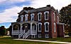
| 1
|
Arnheim
|
 Arnheim Arnheim
|
May 30, 2002
(
#02000589
)
|
40 Dalton Dr.
37°08′11″N
80°34′08″W
/
37.136389°N 80.568889°W
/
37.136389; -80.568889
(
Arnheim
)
|
|
| 2
|
East Radford Historic District
|
 East Radford Historic District East Radford Historic District
|
May 11, 2000
(
#00000491
)
|
Norwood, Stockton, and Downey Sts., and Grove Ave.
37°08′23″N
80°33′24″W
/
37.139722°N 80.556667°W
/
37.139722; -80.556667
(
East Radford Historic District
)
|
|
| 3
|
Glencoe
|
 Glencoe Glencoe
|
November 22, 2000
(
#00001439
)
|
600 Unruh Drive
37°07′56″N
80°34′50″W
/
37.132361°N 80.580417°W
/
37.132361; -80.580417
(
Glencoe
)
|
|
| 4
|
Halwyck
|
 Halwyck Halwyck
|
August 29, 1997
(
#97001074
)
|
915 Tyler Ave.
37°07′55″N
80°32′55″W
/
37.131944°N 80.548611°W
/
37.131944; -80.548611
(
Halwyck
)
|
|
| 5
|
Harvey House
|
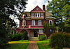 Harvey House Harvey House
|
July 30, 1976
(
#76002228
)
|
706 Harvey St.
37°07′41″N
80°34′12″W
/
37.128194°N 80.570000°W
/
37.128194; -80.570000
(
Harvey House
)
|
|
| 6
|
Ingles Bottom Archeological Sites
|
 Ingles Bottom Archeological Sites Ingles Bottom Archeological Sites
|
December 5, 1978
(
#78003032
)
|
On the
New River
across from Ingles Ferry
[6]
37°06′13″N
80°35′01″W
/
37.103611°N 80.583611°W
/
37.103611; -80.583611
(
Ingles Bottom Archeological Sites
)
|
|
| 7
|
La Riviere
|
 La Riviere La Riviere
|
August 16, 1994
(
#94000991
)
|
5 Ingles St.
37°06′58″N
80°35′38″W
/
37.116111°N 80.593889°W
/
37.116111; -80.593889
(
La Riviere
)
|
|
| 8
|
West Radford Commercial Historic District
|
 West Radford Commercial Historic District West Radford Commercial Historic District
|
January 19, 2005
(
#04001541
)
|
100, 200, and 300 blocks of W. Main St.
37°08′04″N
80°34′28″W
/
37.134444°N 80.574444°W
/
37.134444; -80.574444
(
West Radford Commercial Historic District
)
|
|
See also
[
edit
]
References
[
edit
]
- ^
The latitude and longitude information provided in this table was derived originally from the National Register Information System, which has been found to be fairly accurate for about 99% of listings. Some locations in this table may have been corrected to current GPS standards.
- ^
National Park Service,
United States Department of the Interior
,
"National Register of Historic Places: Weekly List Actions"
, retrieved June 14, 2024.
- ^
Numbers represent an alphabetical ordering by significant words. Various colorings, defined
here
, differentiate
National Historic Landmarks
and
historic districts
from other NRHP buildings, structures, sites or objects.
- ^
"National Register Information System"
.
National Register of Historic Places
.
National Park Service
. April 24, 2008.
- ^
The eight-digit number below each date is the number assigned to each location in the
National Register Information System
database, which can be viewed by clicking the number.
- ^
Loth, Calder, ed.
The Virginia Landmarks Register
.
Charlottesville
:
University of Virginia Press
, 414.
|
|---|
Lists
by county
| | |
|---|
Lists
by city
| |
|---|
| Other lists
| |
|---|
|
