From Wikipedia, the free encyclopedia
 Location of Owen County in Kentucky
This is a list of the
National Register of Historic Places listings in Owen County, Kentucky
.
This is intended to be a complete list of the properties and districts on the
National Register of Historic Places
in
Owen County
,
Kentucky
,
United States
. The locations of National Register properties and districts for which the latitude and longitude coordinates are included below, may be seen in a map.
[1]
There are 17 properties and districts listed on the National Register in the county.
This
National Park Service
list is complete through
NPS recent listings
posted June 7, 2024.
[2]
Contents:
Counties in Kentucky
Current listings
[
edit
]
| [3]
|
Name on the Register
|
Image
|
Date listed
[4]
|
Location
| City or town
|
Description
|
| 1
|
Mason Brown House
|
Upload image
|
April 27, 1998
(
#98000325
)
|
0.5 miles east of end of Brown's Bottom Rd.
38°25′52″N
84°56′28″W
/
38.431111°N 84.941111°W
/
38.431111; -84.941111
(
Mason Brown House
)
| Gratz
|
|
| 2
|
Byrns Landing
|
Upload image
|
August 19, 1997
(
#97000865
)
|
Old Landing Rd.
38°25′23″N
84°53′07″W
/
38.423056°N 84.885278°W
/
38.423056; -84.885278
(
Byrns Landing
)
| Owenton
|
|
| 3
|
Central Owenton Historic District
|
 Central Owenton Historic District Central Owenton Historic District
|
September 4, 1984
(
#84001893
)
|
Roughly Bryan, Madison, Seminary, and Thomas Sts.
38°32′10″N
84°50′14″W
/
38.536111°N 84.837222°W
/
38.536111; -84.837222
(
Central Owenton Historic District
)
| Owenton
|
|
| 4
|
L.O. Cox House
|
 L.O. Cox House L.O. Cox House
|
September 4, 1984
(
#84001895
)
|
311 N. Main St.
38°32′22″N
84°50′12″W
/
38.539444°N 84.836667°W
/
38.539444; -84.836667
(
L.O. Cox House
)
| Owenton
|
|
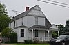
| 5
|
Ford House
|
 Ford House Ford House
|
September 4, 1984
(
#84001897
)
|
311 S. Main St.
38°31′59″N
84°50′05″W
/
38.533056°N 84.834722°W
/
38.533056; -84.834722
(
Ford House
)
| Owenton
|
|
| 6
|
Enos Hardin Farm
|
Upload image
|
August 8, 1997
(
#97000868
)
|
Junction of Rock Rd. and the
Kentucky River
38°22′55″N
84°53′45″W
/
38.381944°N 84.895833°W
/
38.381944; -84.895833
(
Enos Hardin Farm
)
| Owenton
|
|
| 7
|
Highfield
|
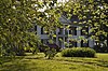 Highfield Highfield
|
November 17, 1977
(
#77000640
)
|
303 N. Adams St.
38°32′18″N
84°50′06″W
/
38.538333°N 84.835000°W
/
38.538333; -84.835000
(
Highfield
)
| Owenton
|
|
| 8
|
Jacob Hunter House
|
Upload image
|
January 8, 1987
(
#87000204
)
|
Off
Kentucky Route 325
near the Big South Fork of the
Kentucky River
38°33′18″N
84°57′47″W
/
38.555°N 84.963056°W
/
38.555; -84.963056
(
Jacob Hunter House
)
| New Liberty
|
|
| 9
|
William Linsey House
|
 William Linsey House William Linsey House
|
September 4, 1984
(
#84001900
)
|
220 W. Seminary St.
38°32′11″N
84°50′19″W
/
38.536250°N 84.838611°W
/
38.536250; -84.838611
(
William Linsey House
)
| Owenton
|
|
| 10
|
McKay House
|
 McKay House McKay House
|
September 4, 1984
(
#84001902
)
|
105 E. Adair St.
38°32′04″N
84°50′08″W
/
38.534583°N 84.835556°W
/
38.534583; -84.835556
(
McKay House
)
| Owenton
|
|
| 11
|
Monterey Grade School
|
Upload image
|
August 19, 1997
(
#97000869
)
|
9725
U.S. Route 127
S.
38°25′52″N
84°52′17″W
/
38.431111°N 84.871389°W
/
38.431111; -84.871389
(
Monterey Grade School
)
| Owenton
|
|
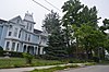
| 12
|
Monterey Historic District
|
Upload image
|
August 19, 1997
(
#97000867
)
|
Roughly bounded by
U.S. Route 127
, High, Hillcrest, and Taylor Sts.
38°25′20″N
84°52′22″W
/
38.422222°N 84.872778°W
/
38.422222; -84.872778
(
Monterey Historic District
)
| Monterey
|
Covers about 14 blocks.
|
| 13
|
New Liberty Historic District
|
 New Liberty Historic District New Liberty Historic District
|
January 4, 2001
(
#00001601
)
|
Kentucky Route 227
, roughly between Kentucky Routes
36
and
978
38°36′52″N
84°54′27″W
/
38.614444°N 84.9075°W
/
38.614444; -84.9075
(
New Liberty Historic District
)
| New Liberty
|
|
| 14
|
North Main-North Adams Historic District
|
 North Main-North Adams Historic District North Main-North Adams Historic District
|
September 4, 1984
(
#84001905
)
|
N. Main, N. Adams, Bryan, and North Sts.
38°32′18″N
84°50′07″W
/
38.538333°N 84.835278°W
/
38.538333; -84.835278
(
North Main-North Adams Historic District
)
| Owenton
|
|
| 15
|
Old Cedar Baptist Church
|
Upload image
|
September 5, 1997
(
#97000870
)
|
1040 Claxon Ridge Rd.
38°23′49″N
84°50′55″W
/
38.396944°N 84.848611°W
/
38.396944; -84.848611
(
Old Cedar Baptist Church
)
| Owenton
|
|
| 16
|
Owen County Courthouse and Jail
|
 Owen County Courthouse and Jail Owen County Courthouse and Jail
|
May 6, 1976
(
#76000937
)
|
N. Thomas and N. Madison Sts.
38°32′10″N
84°50′15″W
/
38.536111°N 84.8375°W
/
38.536111; -84.8375
(
Owen County Courthouse and Jail
)
| Owenton
|
|
| 17
|
E.E. Settle House
|
 E.E. Settle House E.E. Settle House
|
September 4, 1984
(
#84001910
)
|
403-405 N. Adams St.
38°32′27″N
84°50′09″W
/
38.540833°N 84.835833°W
/
38.540833; -84.835833
(
E.E. Settle House
)
| Owenton
|
|
See also
[
edit
]
References
[
edit
]
- ^
The latitude and longitude information provided in this table was derived originally from the National Register Information System, which has been found to be fairly accurate for about 99% of listings. Some locations in this table may have been corrected to current GPS standards.
- ^
National Park Service,
United States Department of the Interior
,
"National Register of Historic Places: Weekly List Actions"
, retrieved June 7, 2024.
- ^
Numbers represent an alphabetical ordering by significant words. Various colorings, defined
here
, differentiate
National Historic Landmarks
and
historic districts
from other NRHP buildings, structures, sites or objects.
- ^
The eight-digit number below each date is the number assigned to each location in the
National Register Information System
database, which can be viewed by clicking the number.
|
|---|
| Topics
| |
|---|
| Lists by state
| |
|---|
| Lists by insular areas
| |
|---|
| Lists by associated state
| |
|---|
| Other areas
| |
|---|
| Related
| |
|---|
|
