From Wikipedia, the free encyclopedia
 Location of Osage County in Missouri
This is a list of the
National Register of Historic Places listings in Osage County, Missouri
.
This is intended to be a complete list of the properties and districts on the
National Register of Historic Places
in
Osage County
,
Missouri
,
United States
. Latitude and longitude coordinates are provided for many National Register properties and districts; these locations may be seen together in a map.
[1]
There are 9 properties and districts listed on the National Register in the county.
This
National Park Service
list is complete through
NPS recent listings
posted June 14, 2024.
[2]
Current listings
[
edit
]
| [3]
|
Name on the Register
|
Image
|
Date listed
[4]
|
Location
| City or town
|
Description
|
| 1
|
Bonnots Mill Historic District
|
Upload image
|
January 21, 1993
(
#92001738
)
|
Roughly Old Mill Rd., Riverside Dr., Highwater Rd., Iris Ave., Wildwood Ln., Hwy. A and Main, Short and Church Hill Sts.
38°34′38″N
91°57′47″W
/
38.577222°N 91.963056°W
/
38.577222; -91.963056
(
Bonnots Mill Historic District
)
| Bonnots Mill
|
|
| 2
|
Chamois Public School
|
Upload image
|
June 26, 2003
(
#03000295
)
|
402 S. Main St.
38°40′23″N
91°46′06″W
/
38.673056°N 91.768333°W
/
38.673056; -91.768333
(
Chamois Public School
)
| Chamois
|
|
| 3
|
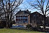
Dauphine Hotel
|
 Dauphine Hotel Dauphine Hotel
|
November 14, 1980
(
#80002386
)
|
Off
Route A
38°34′44″N
91°57′51″W
/
38.578889°N 91.964167°W
/
38.578889; -91.964167
(
Dauphine Hotel
)
| Bonnots Mill
|
|
| 4
|
Huber's Ferry Farmstead Historic District
|
 Huber's Ferry Farmstead Historic District Huber's Ferry Farmstead Historic District
|
January 15, 1999
(
#98001609
)
|
Junction of U.S. Routes
50
and
63
38°29′27″N
92°00′23″W
/
38.490833°N 92.006389°W
/
38.490833; -92.006389
(
Huber's Ferry Farmstead Historic District
)
| Jefferson City
|
|
| 5
|
Osage County Poorhouse
|
 Osage County Poorhouse Osage County Poorhouse
|
February 13, 1998
(
#98000038
)
|
Route 621
, 0.5 miles (0.80 km) south of Linn
38°28′45″N
91°51′18″W
/
38.479167°N 91.855°W
/
38.479167; -91.855
(
Osage County Poorhouse
)
| Linn
|
|
| 6
|
Sacred Heart Catholic Church and Parsonage
|
Upload image
|
September 9, 1982
(
#82003155
)
|
Route U
38°23′49″N
91°52′53″W
/
38.396944°N 91.881389°W
/
38.396944; -91.881389
(
Sacred Heart Catholic Church and Parsonage
)
| Rich Fountain
|
|
| 7
|
St. Joseph Church
|
 St. Joseph Church St. Joseph Church
|
April 11, 1972
(
#72000726
)
|
Main St.
38°26′28″N
91°59′45″W
/
38.441111°N 91.995833°W
/
38.441111; -91.995833
(
St. Joseph Church
)
| Westphalia
|
|
| 8
|
Alvah Washington Townley Farmstead Historic District
|
Upload image
|
August 5, 1999
(
#99000937
)
|
304 S. Market St.
38°40′25″N
91°46′10″W
/
38.673611°N 91.769444°W
/
38.673611; -91.769444
(
Alvah Washington Townley Farmstead Historic District
)
| Chamois
|
|
| 9
|
Dr. Enoch T. and Amy Zewicki House
|
 Dr. Enoch T. and Amy Zewicki House Dr. Enoch T. and Amy Zewicki House
|
February 27, 2002
(
#02000121
)
|
402 E. Main St.
38°29′06″N
91°51′02″W
/
38.485°N 91.850556°W
/
38.485; -91.850556
(
Dr. Enoch T. and Amy Zewicki House
)
| Linn
|
|
See also
[
edit
]
References
[
edit
]
- ^
The latitude and longitude information provided in this table was derived originally from the National Register Information System, which has been found to be fairly accurate for about 99% of listings. Some locations in this table may have been corrected to current GPS standards.
- ^
National Park Service,
United States Department of the Interior
,
"National Register of Historic Places: Weekly List Actions"
, retrieved June 14, 2024.
- ^
Numbers represent an alphabetical ordering by significant words. Various colorings, defined
here
, differentiate
National Historic Landmarks
and
historic districts
from other NRHP buildings, structures, sites or objects.
- ^
The eight-digit number below each date is the number assigned to each location in the
National Register Information System
database, which can be viewed by clicking the number.
|
|---|
| Topics
| |
|---|
| Lists by state
| |
|---|
| Lists by insular areas
| |
|---|
| Lists by associated state
| |
|---|
| Other areas
| |
|---|
| Related
| |
|---|
|
|
|---|
Lists
by county
| | |
|---|
| Other lists
| |
|---|
|
