From Wikipedia, the free encyclopedia
 Location of Noxubee County in Mississippi
This is a list of the
National Register of Historic Places listings in Noxubee County, Mississippi
.
This is intended to be a complete list of the properties and districts on the
National Register of Historic Places
in
Noxubee County
,
Mississippi
,
United States
. Latitude and longitude coordinates are provided for many National Register properties and districts; these locations may be seen together in a map.
[1]
There are 13 properties and districts listed on the National Register in the county, including 1
National Historic Landmark
.
This
National Park Service
list is complete through
NPS recent listings
posted June 14, 2024.
[2]
Current listings
[
edit
]
| [3]
|
Name on the Register
[4]
|
Image
|
Date listed
[5]
|
Location
| City or town
|
Description
|
| 1
|
Central Shuqualak Historic District
|
Upload image
|
August 26, 1980
(
#80002297
)
|
Off
Mississippi Highway 39
32°58′47″N
88°34′01″W
/
32.979722°N 88.566944°W
/
32.979722; -88.566944
(
Central Shuqualak Historic District
)
| Shuqualak
|
|
| 2
|
Dancing Rabbit Creek Treaty Site
|
 Dancing Rabbit Creek Treaty Site Dancing Rabbit Creek Treaty Site
|
April 3, 1973
(
#73001024
)
|
Around Dancing Rabbit Spring, southwest of Macon
[6]
33°00′35″N
88°45′15″W
/
33.009861°N 88.754167°W
/
33.009861; -88.754167
(
Dancing Rabbit Creek Treaty Site
)
| Macon
|
|
| 3
|
Flora House
|
 Flora House Flora House
|
December 2, 1982
(
#82000577
)
|
6872 MS-39
32°58′40″N
88°34′18″W
/
32.977778°N 88.571667°W
/
32.977778; -88.571667
(
Flora House
)
| Shuqualak
|
|
| 4
|
Goodwin-Harrison House
|
 Goodwin-Harrison House Goodwin-Harrison House
|
November 28, 1980
(
#80002296
)
|
213 N. Jefferson St.
33°06′48″N
88°33′37″W
/
33.113333°N 88.560278°W
/
33.113333; -88.560278
(
Goodwin-Harrison House
)
| Macon
|
|
| 5
|
Macon Historic District
|
 Macon Historic District Macon Historic District
|
March 21, 2002
(
#02000207
)
|
Roughly bounded by Adams, Pearl, West, and Wayne Sts.
33°07′09″N
88°33′39″W
/
33.119167°N 88.560833°W
/
33.119167; -88.560833
(
Macon Historic District
)
| Macon
|
|
| 6
|
Maudwin
|
 Maudwin Maudwin
|
August 29, 1985
(
#85001929
)
|
101 Washington St.
33°06′36″N
88°33′32″W
/
33.11°N 88.558889°W
/
33.11; -88.558889
(
Maudwin
)
| Macon
|
|
| 7
|
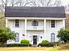
McGeehee-Ames House
|
 McGeehee-Ames House McGeehee-Ames House
|
July 10, 1992
(
#92000853
)
|
Magnolia Dr. south of its junction with
U.S. Route 45
33°08′29″N
88°33′20″W
/
33.141389°N 88.555556°W
/
33.141389; -88.555556
(
McGeehee-Ames House
)
| Macon
|
|
| 8
|
Old Noxubee County Jail
|
 Old Noxubee County Jail Old Noxubee County Jail
|
January 8, 1979
(
#79001333
)
|
209 Monroe St.
33°06′22″N
88°33′38″W
/
33.106111°N 88.560556°W
/
33.106111; -88.560556
(
Old Noxubee County Jail
)
| Macon
|
|
| 9
|
Old Noxubee County Jail of 1870
|
 Old Noxubee County Jail of 1870 Old Noxubee County Jail of 1870
|
January 3, 1991
(
#90002102
)
|
503 S. Washington St.
33°06′02″N
88°33′35″W
/
33.100556°N 88.559722°W
/
33.100556; -88.559722
(
Old Noxubee County Jail of 1870
)
| Macon
|
|
| 10
|
Running Water Creek Bridge
|
Upload image
|
November 16, 1988
(
#88002487
)
|
Spans Running Water Creek on a county road
33°01′05″N
88°36′50″W
/
33.018056°N 88.613889°W
/
33.018056; -88.613889
(
Running Water Creek Bridge
)
| Shuqualak
|
|
| 11
|
Old Salem School
|
 Old Salem School Old Salem School
|
January 26, 1990
(
#89002323
)
|
3.4 miles west of Macon on
Mississippi Highway 14
33°05′42″N
88°36′51″W
/
33.095°N 88.614167°W
/
33.095; -88.614167
(
Old Salem School
)
| Macon
|
|
| 12
|
William Henry Scales House
|
 William Henry Scales House William Henry Scales House
|
August 9, 2002
(
#02000858
)
|
1108 Magnolia Dr.
33°07′58″N
88°33′20″W
/
33.132778°N 88.555556°W
/
33.132778; -88.555556
(
William Henry Scales House
)
| Macon
|
|
| 13
|
Yates-Flora House
|
 Yates-Flora House Yates-Flora House
|
December 2, 1982
(
#82000578
)
|
100 N. Wayne St.
33°06′37″N
88°33′28″W
/
33.110278°N 88.557778°W
/
33.110278; -88.557778
(
Yates-Flora House
)
| Macon
|
|
See also
[
edit
]
References
[
edit
]
- ^
The latitude and longitude information provided in this table was derived originally from the National Register Information System, which has been found to be fairly accurate for about 99% of listings. Some locations in this table may have been corrected to current GPS standards.
- ^
National Park Service,
United States Department of the Interior
,
"National Register of Historic Places: Weekly List Actions"
, retrieved June 14, 2024.
- ^
Numbers represent an alphabetical ordering by significant words. Various colorings, defined
here
, differentiate
National Historic Landmarks
and
historic districts
from other NRHP buildings, structures, sites or objects.
- ^
"National Register Information System"
.
National Register of Historic Places
.
National Park Service
. March 13, 2009.
- ^
The eight-digit number below each date is the number assigned to each location in the
National Register Information System
database, which can be viewed by clicking the number.
- ^
Location derived from its
NHL nomination form
; the NRIS lists the site as "Address Restricted"
|
|---|
Lists
by county
| | |
|---|
| Other lists
| |
|---|
|
