| [2]
|
Name on the Register
|
Image
|
Date listed
[3]
|
Location
| Neighborhood
[4]
|
Description
|
| 1
|
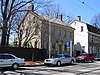
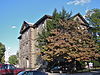
Alden Park Manor
|
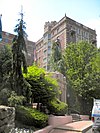 Alden Park Manor Alden Park Manor
|
August 15, 1980
(
#80003606
)
|
School House Lane and Wissahickon Avenue
40°01′34″N
75°11′10″W
/
40.0261°N 75.1861°W
/
40.0261; -75.1861
(
Alden Park Manor
)
| Germantown
|
|
| 2
|
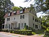
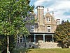
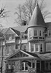
Anglecot
|
 Anglecot Anglecot
|
April 19, 1982
(
#82003806
)
|
Prospect Street and Evergreen Avenue
40°04′51″N
75°12′14″W
/
40.0808°N 75.2039°W
/
40.0808; -75.2039
(
Anglecot
)
| Chestnut Hill
|
|
| 3
|
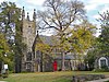
Awbury Historic District
|
 Awbury Historic District Awbury Historic District
|
May 2, 2001
(
#01000462
)
|
Roughly bounded by Chew Avenue, Avonhoe Road, Devon Place, Haines and Ardleigh Streets, and the Arboretum boundary.
40°03′06″N
75°10′14″W
/
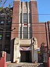
40.0517°N 75.1706°W
/
40.0517; -75.1706
(
Awbury Historic District
)
| East Germantown
|
|
| 4
|
Beggarstown School
|
 Beggarstown School Beggarstown School
|
November 23, 1971
(
#71000718
)
|
6669 Germantown Avenue
40°03′05″N
75°11′06″W
/
40.0514°N 75.185°W
/
40.0514; -75.185
(
Beggarstown School
)
| Mount Airy
|
|
| 5
|
Bellevue Worsted Mills
|
 Bellevue Worsted Mills Bellevue Worsted Mills
|
September 10, 2021
(
#100006880
)
|
5127 Belfield Avenue
40°02′13″N
75°09′35″W
/
40.0369°N 75.1598°W
/
40.0369; -75.1598
(
Bellevue Worsted Mills
)
| Wister
|
|
| 6
|
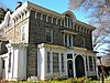
Daniel Billmeyer House
|
 Daniel Billmeyer House Daniel Billmeyer House
|
December 13, 1971
(
#71000719
)
|
6504 Germantown Avenue
40°02′55″N
75°11′03″W
/
40.0486°N 75.1842°W
/
40.0486; -75.1842
(
Daniel Billmeyer House
)
| Mount Airy
|
|
| 7
|
Michael Billmeyer House
|
 Michael Billmeyer House Michael Billmeyer House
|
January 13, 1972
(
#72001145
)
|
6505?6507 Germantown Avenue
40°02′54″N
75°11′02″W
/
40.0483°N 75.1839°W
/
40.0483; -75.1839
(
Michael Billmeyer House
)
| Mount Airy
|
|
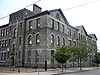
| 8
|
Chestnut Hill Historic District
|
 Chestnut Hill Historic District Chestnut Hill Historic District
|
June 20, 1985
(
#85001334
)
|
Roughly bounded by Fairmount Park and the Montgomery County line
40°04′18″N
75°12′47″W
/
40.0717°N 75.2131°W
/
40.0717; -75.2131
(
Chestnut Hill Historic District
)
| Chestnut Hill
|
|
| 9
|
Clarkson-Watson House
|
 Clarkson-Watson House Clarkson-Watson House
|
April 2, 1973
(
#73001661
)
|
5275?5277 Germantown Avenue
40°01′56″N
75°10′08″W
/
40.0322°N 75.1689°W
/
40.0322; -75.1689
(
Clarkson-Watson House
)
| Wister
|
|
| 10
|
Cliveden
|
 Cliveden Cliveden
|
October 15, 1966
(
#66000677
)
|
6401 Germantown Avenue
40°02′50″N
75°10′54″W
/
40.0472°N 75.1817°W
/
40.0472; -75.1817
(
Cliveden
)
| Mount Airy
|
|
| 11
|
Colonial Germantown Historic District
|
 Colonial Germantown Historic District Colonial Germantown Historic District
|
October 15, 1966
(
#66000678
)
|
Germantown Avenue between Windrim Avenue and Upsal Street; also the 6500?7600 blocks of Germantown Avenue from the Fort Washington branch of the
Pennsylvania Railroad
to Sharpnack Street
40°02′11″N
75°10′29″W
/
40.0364°N 75.1747°W
/
40.0364; -75.1747
(
Colonial Germantown Historic District
)
| Germantown
and
Mount Airy
|
|
| 12
|
Compton and Bloomfield
|
 Compton and Bloomfield Compton and Bloomfield
|
December 22, 1978
(
#78002445
)
|
9414 Meadowbrook Avenue
40°05′21″N
75°13′29″W
/
40.0892°N 75.2247°W
/
40.0892; -75.2247
(
Compton and Bloomfield
)
| Chestnut Hill
|
Extends into
Montgomery County
|
| 13
|
Conyngham-Hacker House
|
 Conyngham-Hacker House Conyngham-Hacker House
|
January 13, 1972
(
#72001149
)
|
5214 Germantown Avenue
40°01′52″N
75°10′04″W
/
40.0311°N 75.1678°W
/
40.0311; -75.1678
(
Conyngham-Hacker House
)
| Germantown
|
|
| 14
|
Delmar Apartments
|
 Delmar Apartments Delmar Apartments
|
November 14, 1982
(
#82001545
)
|
319 West Chelten Avenue
40°01′47″N
75°10′54″W
/
40.0297°N 75.1817°W
/
40.0297; -75.1817
(
Delmar Apartments
)
| Germantown
|
|
| 15
|
Deshler-Morris House
|
 Deshler-Morris House Deshler-Morris House
|
January 13, 1972
(
#72000095
)
|
5442 Germantown Avenue
40°02′01″N
75°10′22″W
/
40.0336°N 75.1728°W
/
40.0336; -75.1728
(
Deshler-Morris House
)
| Germantown
|
|
| 16
|
James Dobson School
|
 James Dobson School James Dobson School
|
November 18, 1988
(
#88002264
)
|
4665 Umbria Street
40°01′52″N
75°13′50″W
/
40.0311°N 75.2306°W
/
40.0311; -75.2306
(
James Dobson School
)
| Manayunk
|
|
| 17
|
Druim Moir Historic District
|
 Druim Moir Historic District Druim Moir Historic District
|
December 11, 1979
(
#79002318
)
|
Bounded by Fairmount Park, Cherokee Street, Hartwell Lane, and Valley Green Drive
40°03′33″N
75°12′52″W
/
40.0592°N 75.2144°W
/
40.0592; -75.2144
(
Druim Moir Historic District
)
| Chestnut Hill
|
|
| 18
|
Eleanor Cope Emlen School of Practice
|
 Eleanor Cope Emlen School of Practice Eleanor Cope Emlen School of Practice
|
November 18, 1988
(
#88002267
)
|
6501 Chew Street
40°03′15″N
75°10′42″W
/
40.0542°N 75.1783°W
/
40.0542; -75.1783
(
Eleanor Cope Emlen School of Practice
)
| Mount Airy
|
|
| 19
|
Margaret Esherick House
|
 Margaret Esherick House Margaret Esherick House
|
August 21, 2023
(
#100009239
)
|
204 Sunrise Ln.
40°04′21″N
75°12′23″W
/
40.0724°N 75.2065°W
/
40.0724; -75.2065
(
Margaret Esherick House
)
| Chestnut Hill
|
|
| 20
|
Fairelawn
|
 Fairelawn Fairelawn
|
September 5, 2023
(
#100009301
)
|
30 Pelham Rd.
40°03′09″N
75°11′14″W
/
40.0525°N 75.1871°W
/
40.0525; -75.1871
(
Fairelawn
)
| Mount Airy
|
|
| 21
|
Fairmount Park
|
 Fairmount Park Fairmount Park
|
February 7, 1972
(
#72001151
)
|
Both banks of the
Schuylkill River
and the
Wissahickon Creek
from Spring Garden Street to Northwestern Avenue
40°01′15″N
75°12′46″W
/
40.0208°N 75.2128°W
/
40.0208; -75.2128
(
Fairmount Park
)
| Fairmount Park
|
Extends into
North
and
West
Philadelphia
|
| 22
|
First Baptist Church of Germantown
|
 First Baptist Church of Germantown First Baptist Church of Germantown
|
August 21, 2023
(
#100009240
)
|
40 East Price Street
40°02′15″N
75°10′29″W
/
40.0375°N 75.1746°W
/
40.0375; -75.1746
(
First Baptist Church of Germantown
)
| Germantown
|
|
| 23
|
Fisher's Lane
|
 Fisher's Lane Fisher's Lane
|
February 20, 1980
(
#80003611
)
|
East Logan Street
40°01′46″N
75°09′40″W
/
40.0294°N 75.1611°W
/
40.0294; -75.1611
(
Fisher's Lane
)
| Wister
|
|
| 24
|
Fitler School
|
 Fitler School Fitler School
|
December 4, 1986
(
#86003281
)
|
Southeast corner of Seymour and Knox Streets
40°01′33″N
75°10′00″W
/
40.0258°N 75.1667°W
/
40.0258; -75.1667
(
Fitler School
)
| Germantown
|
|
| 25
|
Robert Fulton School
|
 Robert Fulton School Robert Fulton School
|
December 4, 1986
(
#86003284
)
|
64 East Haines Street
40°02′24″N
75°10′36″W
/
40.04°N 75.1768°W
/
40.04; -75.1768
(
Robert Fulton School
)
| Morton
|
|
| 26
|
Germantown Cricket Club
|
 Germantown Cricket Club Germantown Cricket Club
|
February 27, 1987
(
#87000758
)
|
5140 Morris Street
40°01′25″N
75°10′24″W
/
40.0236°N 75.1733°W
/
40.0236; -75.1733
(
Germantown Cricket Club
)
| Germantown
|
|
| 27
|
Germantown Fireproof Storage Warehouse
|
 Germantown Fireproof Storage Warehouse Germantown Fireproof Storage Warehouse
|
July 5, 2022
(
#100007864
)
|
231-253 Church Ln.
40°02′11″N
75°10′10″W
/
40.0364°N 75.1694°W
/
40.0364; -75.1694
(
Germantown Fireproof Storage Warehouse
)
| Germantown
|
|
| 28
|
Germantown Grammar School
|
 Germantown Grammar School Germantown Grammar School
|
December 1, 1986
(
#86003287
)
|
McCallum and Haines Streets
40°02′16″N
75°10′41″W
/
40.0378°N 75.1781°W
/
40.0378; -75.1781
(
Germantown Grammar School
)
| Germantown
|
|
| 29
|
Germantown Jewish Centre
|
 Germantown Jewish Centre Germantown Jewish Centre
|
May 27, 2021
(
#100006587
)
|
400 West Ellet Street
40°03′01″N
75°11′40″W
/
40.0503°N 75.1945°W
/
40.0503; -75.1945
(
Germantown Jewish Centre
)
| Germantown
|
|
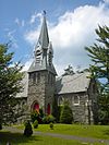
| 30
|
Grace Church, Mt. Airy
|
 Grace Church, Mt. Airy Grace Church, Mt. Airy
|
January 15, 1998
(
#97001654
)
|
224 East Gowen Avenue
40°03′57″N
75°11′19″W
/
40.0658°N 75.1887°W
/
40.0658; -75.1887
(
Grace Church, Mt. Airy
)
| Mount Airy
|
|
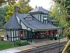
| 31
|
Graver's Lane Station
|
 Graver's Lane Station Graver's Lane Station
|
November 7, 1977
(
#77001184
)
|
Gravers Lane and the
Reading Railroad
line
40°04′39″N
75°12′07″W
/
40.0774°N 75.2019°W
/
40.0774; -75.2019
(
Graver's Lane Station
)
| Chestnut Hill
|
|
| 32
|
Grumblethorpe
|
 Grumblethorpe Grumblethorpe
|
March 16, 1972
(
#72001155
)
|
5267 Germantown Avenue
40°01′56″N
75°10′07″W
/
40.0321°N 75.1685°W
/
40.0321; -75.1685
(
Grumblethorpe
)
| Wister
|
|
| 33
|
Grumblethorpe Tenant House
|
 Grumblethorpe Tenant House Grumblethorpe Tenant House
|
June 19, 1972
(
#72001156
)
|
5269 Germantown Avenue
40°01′56″N
75°10′07″W
/
40.0321°N 75.1686°W
/
40.0321; -75.1686
(
Grumblethorpe Tenant House
)
| Wister
|
|
| 34
|
Happy Hollow Recreation Center
|
 Happy Hollow Recreation Center Happy Hollow Recreation Center
|
April 28, 2014
(
#14000184
)
|
4740 Wayne Avenue
40°01′27″N
75°09′58″W
/
40.024203°N 75.166035°W
/
40.024203; -75.166035
(
Happy Hollow Recreation Center
)
| Germantown
|
|
| 35
|
Charles Wolcott Henry School
|
 Charles Wolcott Henry School Charles Wolcott Henry School
|
November 18, 1988
(
#88002279
)
|
623 Carpenter Lane
40°02′46″N
75°11′47″W
/
40.0461°N 75.1964°W
/
40.0461; -75.1964
(
Charles Wolcott Henry School
)
| Mount Airy
|
|
| 36
|
Robert M. Hogue House
|
 Robert M. Hogue House Robert M. Hogue House
|
January 16, 1986
(
#86000165
)
|
100 Pelham Road
40°03′07″N
75°11′15″W
/
40.0519°N 75.1876°W
/
40.0519; -75.1876
(
Robert M. Hogue House
)
| Mount Airy
|
|
| 37
|
Henry H. Houston School
|
 Henry H. Houston School Henry H. Houston School
|
April 10, 1989
(
#88002283
)
|
135 West Allens Lane
40°03′32″N
75°11′42″W
/
40.0589°N 75.195°W
/
40.0589; -75.195
(
Henry H. Houston School
)
| Mount Airy
|
|
| 38
|
Howell House
|
 Howell House Howell House
|
January 13, 1972
(
#72001159
)
|
5218 Germantown Avenue
40°01′53″N
75°10′04″W
/
40.0314°N 75.1678°W
/
40.0314; -75.1678
(
Howell House
)
| Germantown
|
|
| 39
|
Ivy Lodge
|
 Ivy Lodge Ivy Lodge
|
February 1, 1972
(
#72001161
)
|
29 East Penn Street
40°02′00″N
75°10′07″W
/
40.0332°N 75.1687°W
/
40.0332; -75.1687
(
Ivy Lodge
)
| Wister
|
|
| 40
|
John Story Jenks School
|
 John Story Jenks School John Story Jenks School
|
November 18, 1988
(
#88002286
)
|
8301 Germantown Avenue
40°04′30″N
75°12′12″W
/
40.0749°N 75.2032°W
/
40.0749; -75.2032
(
John Story Jenks School
)
| Chestnut Hill
|
|
| 41
|
John Johnson House
|
 John Johnson House John Johnson House
|
January 13, 1972
(
#72001162
)
|
6306 Germantown Avenue
40°02′36″N
75°10′52″W
/
40.0433°N 75.1811°W
/
40.0433; -75.1811
(
John Johnson House
)
| Germantown
|
|
| 42
|
William Levering School
|
 William Levering School William Levering School
|
November 18, 1988
(
#88002292
)
|
5938 Ridge Avenue
40°01′51″N
75°12′46″W
/
40.0308°N 75.2128°W
/
40.0308; -75.2128
(
William Levering School
)
| Roxborough
|
|
| 43
|
Malvern Hall
|
 Malvern Hall Malvern Hall
|
August 25, 1983
(
#83002273
)
|
6655 McCallum Street
40°02′46″N
75°11′28″W
/
40.046°N 75.1911°W
/
40.046; -75.1911
(
Malvern Hall
)
| Mount Airy
|
|
| 44
|
Manayunk Main Street Historic District
|
 Manayunk Main Street Historic District Manayunk Main Street Historic District
|
March 18, 1983
(
#83002274
)
|
Roughly bounded by the Reading Railroad, Flat Rock Dam, Schuylkill River, and Lot 4025 on Main Street
40°02′00″N
75°14′13″W
/
40.0333°N 75.2369°W
/
40.0333; -75.2369
(
Manayunk Main Street Historic District
)
| Manayunk
|
|
| 45
|
Ebenezer Maxwell House
|
 Ebenezer Maxwell House Ebenezer Maxwell House
|
February 24, 1971
(
#71000728
)
|
200 West Tulpehocken Street
40°02′18″N
75°11′01″W
/
40.0382°N 75.1836°W
/
40.0382; -75.1836
(
Ebenezer Maxwell House
)
| Germantown
|
|
| 46
|
Mayfair House
|
 Mayfair House Mayfair House
|
April 7, 1982
(
#82003811
)
|
401 West Johnson Street
40°02′14″N
75°11′30″W
/
40.0372°N 75.1917°W
/
40.0372; -75.1917
(
Mayfair House
)
| Germantown
|
Destroyed.
[5]
Photo shows empty lot with
Connie Mack
's house in background.
|
| 47
|
McCallum Manor
|
 McCallum Manor McCallum Manor
|
May 9, 1985
(
#85001000
)
|
6653 McCallum Avenue
40°02′43″N
75°11′29″W
/
40.0454°N 75.1913°W
/
40.0454; -75.1913
(
McCallum Manor
)
| Mount Airy
|
|
| 48
|
Thomas Meehan School
|
 Thomas Meehan School Thomas Meehan School
|
November 18, 1988
(
#88002312
)
|
5347?5353 Pulaski Street
40°01′39″N
75°10′30″W
/
40.0275°N 75.175°W
/
40.0275; -75.175
(
Thomas Meehan School
)
| Germantown
|
|
| 49
|
Mennonite Meetinghouse
|
 Mennonite Meetinghouse Mennonite Meetinghouse
|
July 23, 1973
(
#73001663
)
|
6119 Germantown Avenue
40°02′28″N
75°10′45″W
/
40.0412°N 75.1791°W
/
40.0412; -75.1791
(
Mennonite Meetinghouse
)
| Morton
|
|
| 50
|
Thomas Mifflin School
|
 Thomas Mifflin School Thomas Mifflin School
|
November 18, 1988
(
#88002301
)
|
3500 Midvale Avenue
40°00′49″N
75°11′29″W
/
40.0135°N 75.1915°W
/
40.0135; -75.1915
(
Thomas Mifflin School
)
| East Falls
|
|
| 51
|
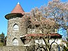
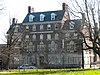
The Monastery
|
 The Monastery The Monastery
|
March 16, 1972
(
#72001164
)
|
Kitchen's Lane at
Wissahickon Creek
40°02′10″N
75°12′13″W
/
40.0361°N 75.2036°W
/
40.0361; -75.2036
(
The Monastery
)
| Fairmount Park
|
|
| 52
|
Mt. Airy Station
|
 Mt. Airy Station Mt. Airy Station
|
September 22, 1977
(
#77001186
)
|
119 East Gowen Avenue
40°03′55″N
75°11′28″W
/
40.0652°N 75.1911°W
/
40.0652; -75.1911
(
Mt. Airy Station
)
| Mount Airy
|
|
| 53
|
Nugent Home for Baptists
|
 Nugent Home for Baptists Nugent Home for Baptists
|
August 30, 2006
(
#06000746
)
|
221 West Johnson Street
40°02′33″N
75°11′11″W
/
40.0424°N 75.1864°W
/
40.0424; -75.1864
(
Nugent Home for Baptists
)
| Mount Airy
|
|
| 54
|
Violet Oakley Studio
|
 Violet Oakley Studio Violet Oakley Studio
|
September 13, 1977
(
#77001188
)
|
627 St. George's Road
40°03′12″N
75°12′19″W
/
40.0532°N 75.2053°W
/
40.0532; -75.2053
(
Violet Oakley Studio
)
| Mount Airy
|
|
| 55
|
Oaks Cloister
|
 Oaks Cloister Oaks Cloister
|
April 22, 2019
(
#100003636
)
|
5829 Wissahickon Avenue & 3 Lehman Ln.
40°02′00″N
75°10′29″W
/
40.0332°N 75.1747°W
/
40.0332; -75.1747
(
Oaks Cloister
)
| Germantown
|
|
| 56
|
Old Germantown Academy and Headmasters' Houses
|
 Old Germantown Academy and Headmasters' Houses Old Germantown Academy and Headmasters' Houses
|
January 13, 1972
(
#72001168
)
|
Schoolhouse Lane and Greene Street
40°02′00″N
75°10′29″W
/
40.0332°N 75.1747°W
/
40.0332; -75.1747
(
Old Germantown Academy and Headmasters' Houses
)
| Germantown
|
|
| 57
|
Pennsylvania Institute for the Deaf and Dumb
|
 Pennsylvania Institute for the Deaf and Dumb Pennsylvania Institute for the Deaf and Dumb
|
May 9, 1985
(
#85000999
)
|
7500 Germantown Avenue
40°03′49″N
75°11′47″W
/
40.0636°N 75.1964°W
/
40.0636; -75.1964
(
Pennsylvania Institute for the Deaf and Dumb
)
| Mount Airy
|
|
| 58
|
Presser Home for Retired Music Teachers
|
 Presser Home for Retired Music Teachers Presser Home for Retired Music Teachers
|
November 8, 2006
(
#06001006
)
|
111 W. Johnson St.
40°02′37″N
75°11′06″W
/
40.0437°N 75.1851°W
/
40.0437; -75.1851
(
Presser Home for Retired Music Teachers
)
| Mount Airy
|
|
| 59
|
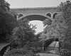
Ridge Avenue Bridge in Philadelphia
|
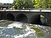 Ridge Avenue Bridge in Philadelphia Ridge Avenue Bridge in Philadelphia
|
June 22, 1988
(
#88000852
)
|
Ridge Avenue over the
Wissahickon Creek
40°00′54″N
75°12′24″W
/
40.0149°N 75.2067°W
/
40.0149; -75.2067
(
Ridge Avenue Bridge in Philadelphia
)
| Wissahickon
|
|
| 60
|
RittenhouseTown Historic District
|
 RittenhouseTown Historic District RittenhouseTown Historic District
|
April 27, 1992
(
#92001878
)
|
208 Lincoln Drive
40°01′43″N
75°11′28″W
/
40.0286°N 75.1911°W
/
40.0286; -75.1911
(
RittenhouseTown Historic District
)
| Fairmount Park
|
|
| 61
|
Theodore Roosevelt Junior High School
|
 Theodore Roosevelt Junior High School Theodore Roosevelt Junior High School
|
November 18, 1988
(
#88002317
)
|
430 East Washington Lane
40°02′54″N
75°10′31″W
/
40.0483°N 75.1753°W
/
40.0483; -75.1753
(
Theodore Roosevelt Junior High School
)
| Morton
|
|
| 62
|
St. Peter's Episcopal Church of Germantown
|
 St. Peter's Episcopal Church of Germantown St. Peter's Episcopal Church of Germantown
|
September 5, 1985
(
#85001960
)
|
6000 Wayne Avenue
40°02′23″N
75°11′01″W
/
40.0397°N 75.1836°W
/
40.0397; -75.1836
(
St. Peter's Episcopal Church of Germantown
)
| Germantown
|
|
| 63
|
Charles Schaeffer School
|
 Charles Schaeffer School Charles Schaeffer School
|
December 4, 1986
(
#86003327
)
|
Germantown Avenue and Abbottsford Road
40°01′37″N
75°09′37″W
/
40.0269°N 75.1603°W
/
40.0269; -75.1603
(
Charles Schaeffer School
)
| Germantown
|
|
| 64
|
Edward B. Seymour House
|
 Edward B. Seymour House Edward B. Seymour House
|
November 5, 1987
(
#87001945
)
|
260 West Johnson Street
40°02′28″N
75°11′13″W
/
40.041°N 75.1869°W
/
40.041; -75.1869
(
Edward B. Seymour House
)
| Mount Airy
|
|
| 65
|
William C. Sharpless House
|
 William C. Sharpless House William C. Sharpless House
|
December 29, 1983
(
#83004249
)
|
5446 Wayne Avenue
40°01′47″N
75°10′34″W
/
40.0297°N 75.1761°W
/
40.0297; -75.1761
(
William C. Sharpless House
)
| Germantown
|
|
| 66
|
Smyser and English Pharmacy
|
 Smyser and English Pharmacy Smyser and English Pharmacy
|
February 20, 2002
(
#02000071
)
|
245?247 West Chelten Avenue
40°01′50″N
75°10′49″W
/
40.0306°N 75.1804°W
/
40.0306; -75.1804
(
Smyser and English Pharmacy
)
| Germantown
|
|
| 67
|
Thomas Mill Covered Bridge
|
 Thomas Mill Covered Bridge Thomas Mill Covered Bridge
|
December 1, 1980
(
#80003621
)
|
Thomas Mill Road
40°04′19″N
75°13′32″W
/
40.0719°N 75.2256°W
/
40.0719; -75.2256
(
Thomas Mill Covered Bridge
)
| Fairmount Park
|
|
| 68
|
Tulpehocken Station Historic District
|
 Tulpehocken Station Historic District Tulpehocken Station Historic District
|
November 26, 1985
(
#85003564
)
|
Roughly bounded by McCallum Street, West Walnut Lane,
Penn Central
railroad tracks, and West Tulpehocken Street
40°02′17″N
75°10′58″W
/
40.0381°N 75.1828°W
/
40.0381; -75.1828
(
Tulpehocken Station Historic District
)
| Germantown
|
|
| 69
|
Upper Roxborough Historic District
|
 Upper Roxborough Historic District Upper Roxborough Historic District
|
May 2, 2001
(
#01000463
)
|
Roughly bounded by Shawmont Avenue, Hagy's Mill Road, and the
Schuylkill River
40°03′24″N
75°14′44″W
/
40.0567°N 75.2456°W
/
40.0567; -75.2456
(
Upper Roxborough Historic District
)
| Roxborough
|
Extends into
Montgomery County
|
| 70
|
Upsala
|
 Upsala Upsala
|
January 13, 1972
(
#72001174
)
|
6430 Germantown Avenue
40°02′48″N
75°10′59″W
/
40.0467°N 75.1831°W
/
40.0467; -75.1831
(
Upsala
)
| Mount Airy
|
|
| 71
|
Sally Watson House
|
 Sally Watson House Sally Watson House
|
March 10, 1982
(
#82003818
)
|
5128 Wayne Avenue
40°01′35″N
75°10′12″W
/
40.0264°N 75.1701°W
/
40.0264; -75.1701
(
Sally Watson House
)
| Germantown
|
|
| 72
|
Wayne Junction Historic District
|
 Wayne Junction Historic District Wayne Junction Historic District
|
April 16, 2012
(
#12000223
)
|
Roughly bounded by W. Berkley Street, Roberts, Germantown, & Wayne Avenues
40°01′19″N
75°09′45″W
/
40.022052°N 75.162386°W
/
40.022052; -75.162386
(
Wayne Junction Historic District
)
| Germantown
|
Factory buildings surrounding the
Wayne Junction station
|
| 73
|
John Wilde and Brother, Inc
|
 John Wilde and Brother, Inc John Wilde and Brother, Inc
|
April 30, 2013
(
#13000258
)
|
3737 Main Street
40°01′00″N
75°12′43″W
/
40.016732°N 75.211976°W
/
40.016732; -75.211976
(
John Wilde and Brother, Inc
)
| Manayunk
|
|
| 74
|
Wissahickon
|
 Wissahickon Wissahickon
|
November 25, 1983
(
#83004257
)
|
Schuyler and Queen Streets
40°01′22″N
75°10′36″W
/
40.0229°N 75.1767°W
/
40.0229; -75.1767
(
Wissahickon
)
| East Falls
|
|
| 75
|
Wissahickon Inn
|
 Wissahickon Inn Wissahickon Inn
|
December 6, 1979
(
#79002333
)
|
500 West Willow Grove Avenue
40°03′44″N
75°12′31″W
/
40.0622°N 75.2086°W
/
40.0622; -75.2086
(
Wissahickon Inn
)
| Chestnut Hill
|
|
| 76
|
Wissahickon Memorial Bridge
|
 Wissahickon Memorial Bridge Wissahickon Memorial Bridge
|
June 22, 1988
(
#88000807
)
|
Henry Avenue over Wissahickon Drive
40°01′27″N
75°11′44″W
/
40.0242°N 75.1956°W
/
40.0242; -75.1956
(
Wissahickon Memorial Bridge
)
| Fairmount Park
|
|
| 77
|
Woman's Medical College of Pennsylvania
|
 Woman's Medical College of Pennsylvania Woman's Medical College of Pennsylvania
|
November 26, 2008
(
#08000785
)
|
3300 Henry Avenue
40°00′42″N
75°11′03″W
/
40.0117°N 75.1842°W
/
40.0117; -75.1842
(
Woman's Medical College of Pennsylvania
)
| East Falls
|
|
| 78
|
Wyck House
|
 Wyck House Wyck House
|
October 26, 1971
(
#71000736
)
|
6026 Germantown Avenue
40°02′24″N
75°10′43″W
/
40.04°N 75.1785°W
/
40.04; -75.1785
(
Wyck House
)
| Germantown
|
|
| 79
|
YMCA of Germantown
|
 YMCA of Germantown YMCA of Germantown
|
November 14, 1991
(
#91001709
)
|
5722 Greene Street
40°02′04″N
75°10′39″W
/
40.0344°N 75.1774°W
/
40.0344; -75.1774
(
YMCA of Germantown
)
| Germantown
|
|