| [3]
|
Name on the Register
|
Image
|
Date listed
[4]
|
Location
| City or town
|
Description
|
| 1
|
Bank Street-Old Decatur Historic District
|
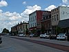 Bank Street-Old Decatur Historic District Bank Street-Old Decatur Historic District
|
March 27, 1980
(
#80000731
)
|
Bank St.; also roughly bounded by Bank, Market, Well and Lee Sts.
34°36′36″N
86°59′06″W
/
34.61°N 86.985°W
/
34.61; -86.985
(
Bank Street-Old Decatur Historic District
)
| Decatur
|
Second set of boundaries represent a boundary increase of
May 16, 1985
, the Bank Street-Old Decatur Historic District
|
| 2
|
Cotaco Opera House
|
 Cotaco Opera House Cotaco Opera House
|
April 29, 1986
(
#86000914
)
|
115 Johnston St., SE.
34°36′10″N
86°59′09″W
/
34.60264°N 86.98587°W
/
34.60264; -86.98587
(
Cotaco Opera House
)
| Decatur
|
|
| 3
|
Crabb-Stewart-Key House
|
 Crabb-Stewart-Key House Crabb-Stewart-Key House
|
November 18, 2011
(
#100004618
)
|
1084 Nat Key Rd.
34°23′34″N
86°51′16″W
/
34.3929°N 86.8545°W
/
34.3929; -86.8545
(
Crabb-Stewart-Key House
)
| Hartselle
vicinity
|
|
| 4
|
Col. Francis Dancy House
|
 Col. Francis Dancy House Col. Francis Dancy House
|
April 28, 1980
(
#80000732
)
|
901 Railroad St., NW.
34°36′53″N
86°59′07″W
/
34.61477°N 86.98518°W
/
34.61477; -86.98518
(
Col. Francis Dancy House
)
| Decatur
|
|
| 5
|
East Old Town Historic District
|
 East Old Town Historic District East Old Town Historic District
|
December 26, 2012
(
#12001079
)
|
NW Church Street to NW Wilson Street
[5]
34°36′59″N
86°59′13″W
/
34.61638°N 86.986849°W
/
34.61638; -86.986849
(
East Old Town Historic District
)
| Decatur
|
|
| 6
|
Forest Home
|
Upload image
|
November 21, 1980
(
#80000733
)
|
East of Trinity
34°36′36″N
87°03′58″W
/
34.61011°N 87.06614°W
/
34.61011; -87.06614
(
Forest Home
)
| Trinity
|
|
| 7
|
Hartselle Downtown Commercial Historic District
|
 Hartselle Downtown Commercial Historic District Hartselle Downtown Commercial Historic District
|
April 22, 1999
(
#99000469
)
|
Roughly along Main, Railroad, Hickory, and Sparkman Sts.
34°26′36″N
86°56′03″W
/
34.443333°N 86.934167°W
/
34.443333; -86.934167
(
Hartselle Downtown Commercial Historic District
)
| Hartselle
|
|
| 8
|
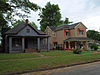
Dr. William E. Murphey House
|
 Dr. William E. Murphey House Dr. William E. Murphey House
|
July 9, 1986
(
#86001547
)
|
Off
U.S. Route 72
34°38′38″N
87°05′53″W
/
34.64377°N 87.09794°W
/
34.64377; -87.09794
(
Dr. William E. Murphey House
)
| Trinity
|
One of the oldest frame houses in Alabama, c. 1818, it was destroyed by a tornado on April 27, 2011.
[6]
|
| 9
|
New Decatur-Albany Historic District
|
 New Decatur-Albany Historic District New Decatur-Albany Historic District
|
July 7, 1995
(
#95000810
)
|
Roughly the 100 block of NE. 2nd Ave., the eastern side of the 100 block and the western side of the 300 block of SE. 2nd Ave., and parts of Johnson and Moulton Sts.; also 136 1st Ave., NE.
34°36′11″N
86°59′06″W
/
34.603056°N 86.985°W
/
34.603056; -86.985
(
New Decatur-Albany Historic District
)
| Decatur
|
Second set of boundaries represents a boundary increase of
February 12, 1999
|
| 10
|
New Decatur-Albany Residential Historic District
|
 New Decatur-Albany Residential Historic District New Decatur-Albany Residential Historic District
|
February 3, 1983
(
#83002981
)
|
Roughly bounded by Gordon Dr., Summerville Rd., Jackson, 8th, Moulton, 6th, and 4th Aves.; also Grant, Jackson, and Sherman Sts. and Gordon and Prospect Drs.
34°36′00″N
86°58′40″W
/
34.6°N 86.977778°W
/
34.6; -86.977778
(
New Decatur-Albany Residential Historic District
)
| Decatur
|
Second set of boundaries represent a boundary increase of
April 14, 2004
, the New Decatur-Albany Residential Historic District. Originally enlisted as Albany Heritage Neighborhood Historic District.
|
| 11
|
Rhea-McEntire House
|
 Rhea-McEntire House Rhea-McEntire House
|
August 30, 1984
(
#84000715
)
|
1105 Sycamore St.
34°37′02″N
86°59′05″W
/
34.61727°N 86.98483°W
/
34.61727; -86.98483
(
Rhea-McEntire House
)
| Decatur
|
|
| 12
|
Green Pryor Rice House
|
 Green Pryor Rice House Green Pryor Rice House
|
July 9, 1986
(
#86001546
)
|
Junction of Madison and Monroe Sts.
34°28′27″N
86°47′43″W
/
34.474174°N 86.795393°W
/
34.474174; -86.795393
(
Green Pryor Rice House
)
| Somerville
|
|
| 13
|
Simpson's Florist
|
Upload image
|
November 6, 2023
(
#100009550
)
|
902 6th Avenue SE
34°35′41″N
86°58′48″W
/
34.5947°N 86.9801°W
/
34.5947; -86.9801
(
Simpson's Florist
)
| Decatur
|
|
| 14
|
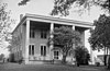
Somerville Courthouse
|
 Somerville Courthouse Somerville Courthouse
|
March 24, 1972
(
#72000177
)
|
State Route 36
34°28′22″N
86°47′54″W
/
34.47289°N 86.79838°W
/
34.47289; -86.79838
(
Somerville Courthouse
)
| Somerville
|
The Somerville Courthouse was built in 1837 in the
Federal style
. It served as the county courthouse for
Morgan County
until the county seat was moved from Somerville to
Decatur
in 1891.
|
| 15
|
Southern Railway Depot
|
 Southern Railway Depot Southern Railway Depot
|
March 10, 1980
(
#80004470
)
|
701 Railroad St., NW.
34°36′49″N
86°59′12″W
/
34.61352°N 86.98656°W
/
34.61352; -86.98656
(
Southern Railway Depot
)
| Decatur
|
|
| 16
|
State Bank Building, Decatur Branch
|
 State Bank Building, Decatur Branch State Bank Building, Decatur Branch
|
March 24, 1972
(
#72000176
)
|
925 Bank St., NE.
34°36′52″N
86°59′01″W
/
34.61431°N 86.9837°W
/
34.61431; -86.9837
(
State Bank Building, Decatur Branch
)
| Decatur
|
|
| 17
|
West Old Town Historic District
|
 West Old Town Historic District West Old Town Historic District
|
December 26, 2012
(
#12001080
)
|
NW Alma Street to NW Vine Street
[5]
34°37′06″N
86°59′39″W
/
34.618235°N 86.994038°W
/
34.618235; -86.994038
(
West Old Town Historic District
)
| Decatur
|
|
| 18
|
Westview
|
 Westview Westview
|
January 18, 1982
(
#82002068
)
|
South of Decatur
34°29′55″N
86°55′52″W
/
34.49861°N 86.93107°W
/
34.49861; -86.93107
(
Westview
)
| Decatur
|
|