From Wikipedia, the free encyclopedia
 Location of Harlan County in Kentucky
This is a list of the
National Register of Historic Places listings in Harlan County, Kentucky
.
It is intended to be a complete list of the properties on the
National Register of Historic Places
in
Harlan County
,
Kentucky
,
United States
. The locations of National Register properties for which the latitude and longitude coordinates are included below, may be seen in a map.
[1]
There are 6 properties listed on the National Register in the county, including 1
National Historic Landmark
. Another property was once listed but has been removed.
This
National Park Service
list is complete through
NPS recent listings
posted June 7, 2024.
[2]
Contents:
Counties in Kentucky
Current listings
[
edit
]
| [3]
|
Name on the Register
|
Image
|
Date listed
[4]
|
Location
| City or town
|
Description
|
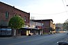
| 1
|
Benham Historic District
|
 Benham Historic District Benham Historic District
|
July 21, 1983
(
#83002785
)
|
Kentucky Route 160
, Central Ave., and McKnight and Cypress Sts.
36°57′48″N
82°57′02″W
/
36.963333°N 82.950556°W
/
36.963333; -82.950556
(
Benham Historic District
)
| Benham
|
Includes the
Benham Company Store
.
|
| 2
|
Cumberland Central Business District
|
 Cumberland Central Business District Cumberland Central Business District
|
March 14, 1996
(
#96000282
)
|
Roughly bounded by Freeman St., Huff Dr., the Poor Fork of the
Cumberland River
, Cumberland Ave., and W. Main St.
36°58′31″N
82°59′27″W
/
36.975278°N 82.990833°W
/
36.975278; -82.990833
(
Cumberland Central Business District
)
| Cumberland
|
|
| 3
|
Cumberland Gap National Historical Park
|
 Cumberland Gap National Historical Park Cumberland Gap National Historical Park
|
October 15, 1966
(
#66000353
)
|
East of Middlesboro along Kentucky-Virginia state line
36°40′00″N
83°27′00″W
/
36.666667°N 83.450000°W
/
36.666667; -83.450000
(
Cumberland Gap National Historical Park
)
| Middlesboro
|
Extends into
Bell County
,
Claiborne County, Tennessee
and
Lee County, Virginia
|
| 4
|
Harlan Commercial District
|
 Harlan Commercial District Harlan Commercial District
|
March 20, 1986
(
#86000461
)
|
Roughly bounded by Mound, Second, Clover, and Main Sts.
36°50′49″N
83°19′20″W
/
36.846944°N 83.322222°W
/
36.846944; -83.322222
(
Harlan Commercial District
)
| Harlan
|
|
| 5
|
Lynch Historic District
|
 Lynch Historic District Lynch Historic District
|
September 15, 2003
(
#03000086
)
|
Roughly bounded by the city limits, the
L&N
railroad bed, Big Looney Creek, and 2nd, Mountain, Highland Terrace, Liberty, and Church Sts.
36°57′52″N
82°55′04″W
/
36.964444°N 82.917778°W
/
36.964444; -82.917778
(
Lynch Historic District
)
| Lynch
|
|
| 6
|
Pine Mountain Settlement School
|
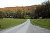 Pine Mountain Settlement School Pine Mountain Settlement School
|
September 6, 1978
(
#78001337
)
|
East of Bledsoe on
Kentucky Route 510
36°56′55″N
83°10′59″W
/
36.948611°N 83.183056°W
/
36.948611; -83.183056
(
Pine Mountain Settlement School
)
| Bledsoe
|
|
Former listing
[
edit
]
See also
[
edit
]
References
[
edit
]
- ^
The latitude and longitude information provided in this table was derived originally from the National Register Information System, which has been found to be fairly accurate for about 99% of listings. Some locations in this table may have been corrected to current GPS standards.
- ^
National Park Service,
United States Department of the Interior
,
"National Register of Historic Places: Weekly List Actions"
, retrieved June 7, 2024.
- ^
a
b
Numbers represent an alphabetical ordering by significant words. Various colorings, defined
here
, differentiate
National Historic Landmarks
and
historic districts
from other NRHP buildings, structures, sites or objects.
- ^
The eight-digit number below each date is the number assigned to each location in the
National Register Information System
database, which can be viewed by clicking the number.
|
|---|
| Topics
| |
|---|
| Lists by state
| |
|---|
| Lists by insular areas
| |
|---|
| Lists by associated state
| |
|---|
| Other areas
| |
|---|
| Related
| |
|---|
|
