From Wikipedia, the free encyclopedia
 Location of Fayette County in Ohio
This is a list of the
National Register of Historic Places listings in Fayette County, Ohio
.
This is intended to be a complete list of the properties and districts on the
National Register of Historic Places
in
Fayette County
,
Ohio
,
United States
. The locations of National Register properties and districts for which the latitude and longitude coordinates are included below, may be seen in a Google map.
[1]
There are 17 properties and districts listed on the National Register in the county.
This
National Park Service
list is complete through
NPS recent listings
posted June 14, 2024.
[2]
Current listings
[
edit
]
| [3]
|
Name on the Register
[4]
|
Image
|
Date listed
[5]
|
Location
| City or town
|
Description
|
| 1
|
William Burnett House
|
 William Burnett House William Burnett House
|
March 22, 1989
(
#89000176
)
|
1613
U.S. Route 62
, SW.
39°31′28″N
83°27′30″W
/
39.524444°N 83.458333°W
/
39.524444; -83.458333
(
William Burnett House
)
| Washington Court House
|
Destroyed
[6]
|
| 2
|
Fayette County Courthouse
|
 Fayette County Courthouse Fayette County Courthouse
|
July 2, 1973
(
#73001433
)
|
Main and Columbus Sts.
39°32′11″N
83°26′24″W
/
39.536389°N 83.44°W
/
39.536389; -83.44
(
Fayette County Courthouse
)
| Washington Court House
|
|
| 3
|
Jackson Mound
|
 Jackson Mound Jackson Mound
|
October 21, 1975
(
#75001397
)
|
East of
State Route 207
, 4 miles (6.4 km) north of Pancoastburg
[7]
39°40′40″N
83°15′55″W
/
39.677778°N 83.265278°W
/
39.677778; -83.265278
(
Jackson Mound
)
| Madison Township
|
|
| 4
|
Judy Chapel
|
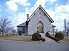 Judy Chapel Judy Chapel
|
May 8, 1998
(
#98000441
)
|
1741 Washington Ave.
39°32′23″N
83°25′16″W
/
39.539722°N 83.421111°W
/
39.539722; -83.421111
(
Judy Chapel
)
| Washington Court House
|
|
| 5
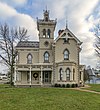
|
Barney Kelley House
|
 Barney Kelley House Barney Kelley House
|
April 17, 1979
(
#79001834
)
|
321 E. East St.
39°32′12″N
83°26′10″W
/
39.536667°N 83.436111°W
/
39.536667; -83.436111
(
Barney Kelley House
)
| Washington Court House
|
|
| 6
|
Jacob Light House
|
 Jacob Light House Jacob Light House
|
January 13, 1989
(
#88003191
)
|
123 W. Circle Ave.
39°31′53″N
83°26′13″W
/
39.531389°N 83.436944°W
/
39.531389; -83.436944
(
Jacob Light House
)
| Washington Court House
|
|
| 7
|
Mark Road Bridge
|
 Mark Road Bridge Mark Road Bridge
|
July 26, 1990
(
#90001118
)
|
Mark Rd. over Sugar Creek, north of Staunton
39°29′13″N
83°28′23″W
/
39.486944°N 83.473056°W
/
39.486944; -83.473056
(
Mark Road Bridge
)
| Concord
and
Union
Townships
|
|
| 8
|
William McCafferty Farmhouse
|
 William McCafferty Farmhouse William McCafferty Farmhouse
|
April 23, 1987
(
#87000633
)
|
7099
State Route 207
, NE., south of Mount Sterling
39°39′31″N
83°16′12″W
/
39.658611°N 83.27°W
/
39.658611; -83.27
(
William McCafferty Farmhouse
)
| Madison Township
|
|
| 9
|
Rawlings-Brownell House
|
 Rawlings-Brownell House Rawlings-Brownell House
|
March 10, 1988
(
#88000207
)
|
318 Rawlings St.
39°32′29″N
83°26′28″W
/
39.541389°N 83.441250°W
/
39.541389; -83.441250
(
Rawlings-Brownell House
)
| Washington Court House
|
|
| 10
|
Robinson-Pavey House
|
 Robinson-Pavey House Robinson-Pavey House
|
April 23, 1987
(
#87000638
)
|
421 W. Court St.
39°31′57″N
83°26′39″W
/
39.5325°N 83.444167°W
/
39.5325; -83.444167
(
Robinson-Pavey House
)
| Washington Court House
|
|
| 11
|
Morris Sharp House
|
 Morris Sharp House Morris Sharp House
|
January 21, 1974
(
#74001483
)
|
517 Columbus St.
39°32′21″N
83°26′06″W
/
39.539167°N 83.435°W
/
39.539167; -83.435
(
Morris Sharp House
)
| Washington Court House
|
|
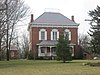
| 12
|
Edward Smith Jr. Farm
|
 Edward Smith Jr. Farm Edward Smith Jr. Farm
|
December 9, 1987
(
#87002110
)
|
2085
U.S. Route 62
, northeast of Washington Court House
39°33′16″N
83°25′10″W
/
39.554444°N 83.419556°W
/
39.554444; -83.419556
(
Edward Smith Jr. Farm
)
| Union Township
|
|
| 13
|
Sollars Farmstead
|
 Sollars Farmstead Sollars Farmstead
|
May 2, 1995
(
#95000493
)
|
Along
State Route 41
south of Washington Court House
[6]
[8]
39°25′31″N
83°23′42″W
/
39.425278°N 83.395000°W
/
39.425278; -83.395000
(
Sollars Farmstead
)
| Perry Township
|
|
| 14
|
Washington Cemetery Historic District
|
 Washington Cemetery Historic District Washington Cemetery Historic District
|
September 6, 2006
(
#06000765
)
|
1741 Washington Ave.
39°32′19″N
83°25′00″W
/
39.538611°N 83.416667°W
/
39.538611; -83.416667
(
Washington Cemetery Historic District
)
| Washington Court House
|
|
| 15
|
Washington Court House Commercial Historic District
|
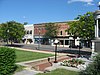 Washington Court House Commercial Historic District Washington Court House Commercial Historic District
|
September 12, 1985
(
#85002351
)
|
Roughly bounded by N. North, East, Hinde, and Market Sts.
39°32′09″N
83°26′20″W
/
39.535833°N 83.438889°W
/
39.535833; -83.438889
(
Washington Court House Commercial Historic District
)
| Washington Court House
|
|
| 16
|
Washington School
|
 Washington School Washington School
|
January 14, 2013
(
#12001181
)
|
318 N. North St.
39°32′24″N
83°26′24″W
/
39.540000°N 83.440000°W
/
39.540000; -83.440000
(
Washington School
)
| Washington Court House
|
|
| 17
|
Woodlawn Farm
|
 Woodlawn Farm Woodlawn Farm
|
February 13, 1986
(
#86000237
)
|
3789
State Route 41
, NW., northwest of Washington Court House
39°34′35″N
83°28′31″W
/
39.576389°N 83.475278°W
/
39.576389; -83.475278
(
Woodlawn Farm
)
| Union Township
|
|
See also
[
edit
]
References
[
edit
]
- ^
The latitude and longitude information provided in this table was derived originally from the National Register Information System, which has been found to be fairly accurate for about 99% of listings. Some locations in this table may have been corrected to current GPS standards.
- ^
National Park Service,
United States Department of the Interior
,
"National Register of Historic Places: Weekly List Actions"
, retrieved June 14, 2024.
- ^
Numbers represent an alphabetical ordering by significant words. Various colorings, defined
here
, differentiate
National Historic Landmarks
and
historic districts
from other NRHP buildings, structures, sites or objects.
- ^
"National Register Information System"
.
National Register of Historic Places
.
National Park Service
. April 24, 2008.
- ^
The eight-digit number below each date is the number assigned to each location in the
National Register Information System
database, which can be viewed by clicking the number.
- ^
a
b
Fayette County Comprehensive Land Use Strategy Plan 2006
, Fayette County, p. 13., 2006. Accessed 2009-07-28.
- ^
Location derived from Owen, Lorrie K., ed.
Dictionary of Ohio Historic Places
. Vol. 1.
St. Clair Shores
: Somerset, 1999, 409-410. The NRIS lists the site as "Address Restricted".
- ^
U.S. Geological Survey Geographic Names Information System: Sollars Cemetery
|
|---|
Lists
by county
| | |
|---|
| Lists by city
| |
|---|
| Other lists
| |
|---|
|
