From Wikipedia, the free encyclopedia
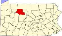 Location of Elk County in Pennsylvania
This is a list of the
National Register of Historic Places listings in Elk County, Pennsylvania
.
This is intended to be a complete list of the properties and districts on the
National Register of Historic Places
in
Elk County
,
Pennsylvania
,
United States
. The locations of National Register properties and districts for which the latitude and longitude coordinates are included below, may be seen in a map.
[1]
There are 12 properties and districts listed on the National Register in the county.
This
National Park Service
list is complete through
NPS recent listings
posted June 14, 2024.
[2]
Current listings
[
edit
]
| [3]
|
Name on the Register
|
Image
|
Date listed
[4]
|
Location
| Municipality
|
Description
|
| 1
|
Bonifels
|
 Bonifels Bonifels
|
December 14, 1978
(
#78002396
)
|
West of Ridgway off Laurel Mill Road
41°25′11″N
78°45′17″W
/
41.419722°N 78.754722°W
/
41.419722; -78.754722
(
Bonifels
)
| Ridgway Township
|
|
| 2
|
Decker's Chapel
|
 Decker's Chapel Decker's Chapel
|
November 12, 1998
(
#98001367
)
|
Junction of Earth Road and
Pennsylvania Route 255
41°24′03″N
78°33′38″W
/
41.400778°N 78.560694°W
/
41.400778; -78.560694
(
Decker's Chapel
)
| St. Marys
|
|
| 3
|
O.B. Grant House
|
 O.B. Grant House O.B. Grant House
|
April 5, 2004
(
#04000268
)
|
610 West Main Street
41°25′17″N
78°44′57″W
/
41.421389°N 78.749167°W
/
41.421389; -78.749167
(
O.B. Grant House
)
| Ridgway
|
|
| 4
|
Irwintown Site
|
 Irwintown Site Irwintown Site
|
September 25, 2012
(
#12000822
)
|
Northern bank of the
Clarion River
, above Hallton
[5]
41°24′03″N
78°54′23″W
/
41.400833°N 78.906389°W
/
41.400833; -78.906389
(
Irwintown Site
)
| Spring Creek Township
|
|
| 5
|
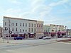
Johnsonburg Commercial Historic District
|
 Johnsonburg Commercial Historic District Johnsonburg Commercial Historic District
|
October 28, 1999
(
#99001290
)
|
Roughly along Center, Bridge, and Market Streets
41°29′20″N
78°40′31″W
/
41.488889°N 78.675278°W
/
41.488889; -78.675278
(
Johnsonburg Commercial Historic District
)
| Johnsonburg
|
|
| 6
|
Lake City School
|
 Lake City School Lake City School
|
June 10, 2008
(
#08000519
)
|
27586 Lake City Road in Lake City
41°21′54″N
78°53′07″W
/
41.365°N 78.885208°W
/
41.365; -78.885208
(
Lake City School
)
| Spring Creek Township
|
|
| 7
|
Loleta Recreation Area
|
 Loleta Recreation Area Loleta Recreation Area
|
November 24, 2015
(
#15000828
)
|
Along Legislative Route 3002 near its junction with Millstone Rd.
41°24′00″N
79°04′55″W
/
41.400029°N 79.082010°W
/
41.400029; -79.082010
(
Loleta Recreation Area
)
| Millstone Township
|
Nomination form
[6]
|
| 8
|
Ridgway Armory
|
 Ridgway Armory Ridgway Armory
|
December 22, 1989
(
#89002078
)
|
72 North Broad Street
41°25′24″N
78°43′48″W
/
41.423333°N 78.73°W
/
41.423333; -78.73
(
Ridgway Armory
)
| Ridgway
|
|
| 9
|
Ridgway Historic District
|
 Ridgway Historic District Ridgway Historic District
|
January 22, 2003
(
#02001180
)
|
Roughly bounded by the borough limits, the
Clarion River
, Erie Alley, and Gallagher Run
41°25′12″N
78°43′40″W
/
41.42°N 78.727778°W
/
41.42; -78.727778
(
Ridgway Historic District
)
| Ridgway
|
|
| 10
|
St. Marys Historic District
|
 St. Marys Historic District St. Marys Historic District
|
November 25, 1998
(
#98001368
)
|
Roughly bounded by Walburga, St. Michael, Fourth, John, and Mill Streets
41°25′43″N
78°33′49″W
/
41.428611°N 78.563611°W
/
41.428611; -78.563611
(
St. Marys Historic District
)
| St. Marys
|
|
| 11
|
Swedish Lutheran Parsonage
|
 Swedish Lutheran Parsonage Swedish Lutheran Parsonage
|
February 24, 2005
(
#05000099
)
|
230 Kane Street in Wilcox
41°34′34″N
78°41′14″W
/
41.576111°N 78.687222°W
/
41.576111; -78.687222
(
Swedish Lutheran Parsonage
)
| Jones Township
|
|
| 12
|
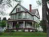
John E. Weidenboerner House
|
 John E. Weidenboerner House John E. Weidenboerner House
|
July 24, 1992
(
#92000931
)
|
North St. Michael Street
41°25′45″N
78°33′43″W
/
41.429167°N 78.562028°W
/
41.429167; -78.562028
(
John E. Weidenboerner House
)
| St. Marys
|
|
See also
[
edit
]
References
[
edit
]
- ^
The latitude and longitude information provided in this table was derived originally from the National Register Information System, which has been found to be fairly accurate for about 99% of listings. Some locations in this table may have been corrected to current GPS standards.
- ^
National Park Service,
United States Department of the Interior
,
"National Register of Historic Places: Weekly List Actions"
, retrieved June 14, 2024.
- ^
Numbers represent an alphabetical ordering by significant words. Various colorings, defined
here
, differentiate
National Historic Landmarks
and
historic districts
from other NRHP buildings, structures, sites or objects.
- ^
The eight-digit number below each date is the number assigned to each location in the
National Register Information System
database, which can be viewed by clicking the number.
- ^
Clarion River Water Trail Map and Guide
, Pennsylvania Fish and Boat Commission, 2004-04. Accessed 2012-11-06.
- ^
Hinkel, Amanda.
"Loleta Recreation Area"
(PDF)
.
phmc.pa.gov
. PHMC. Archived from
the original
(PDF)
on 31 January 2016
. Retrieved
27 January
2016
.
|
|---|
| Topics
| | |
|---|
| Lists by county
| |
|---|
| Lists by city
| |
|---|
| Other lists
| |
|---|
|
