From Wikipedia, the free encyclopedia

This list includes properties and districts listed on the
National Register of Historic Places
in
Caswell County, North Carolina
. Click the "Map of all coordinates" link to the right to view an online map of all properties and districts with latitude and longitude coordinates in the table below.
[1]
Current listings
[
edit
]
This
National Park Service
list is complete through
NPS recent listings
posted June 14, 2024.
[2]
| [3]
|
Name on the Register
[4]
|
Image
|
Date listed
[5]
|
Location
| City or town
|
Description
|
| 1
|
Brown-Graves House and Brown's Store
|
Upload image
|
July 15, 1974
(
#74001334
)
|
SW of Yanceyville on NC 150
36°21′36″N
79°27′04″W
/
36.359872°N 79.451194°W
/
36.359872; -79.451194
(
Brown-Graves House and Brown's Store
)
| Locust Hill
|
|
| 2
|
Caswell County Courthouse
|
 Caswell County Courthouse Caswell County Courthouse
|
June 4, 1973
(
#73001309
)
|
Courthouse Sq.
36°24′11″N
79°20′11″W
/
36.402978°N 79.336333°W
/
36.402978; -79.336333
(
Caswell County Courthouse
)
| Yanceyville
|
|
| 3
|
Caswell County Training School
|
Upload image
|
January 25, 2018
(
#100002047
)
|
403 Dillard School Dr.
36°24′00″N
79°20′01″W
/
36.399887°N 79.333738°W
/
36.399887; -79.333738
(
Caswell County Training School
)
| Yanceyville
|
|
| 4
|
Garland-Buford House
|
 Garland-Buford House Garland-Buford House
|
January 24, 1974
(
#74001333
)
|
N of Leasburg on SR 1561
36°27′27″N
79°08′57″W
/
36.457489°N 79.149039°W
/
36.457489; -79.149039
(
Garland-Buford House
)
| Leasburg
|
|
| 5
|
Graves House
|
 Graves House Graves House
|
November 20, 1974
(
#74001335
)
|
U.S. 158 at NC 86
36°24′15″N
79°19′20″W
/
36.404167°N 79.322222°W
/
36.404167; -79.322222
(
Graves House
)
| Yanceyville
|
|
| 6
|
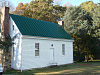
Griers Presbyterian Church and Cemetery
|
 Griers Presbyterian Church and Cemetery Griers Presbyterian Church and Cemetery
|
December 30, 1985
(
#85003187
)
|
SR 1710
36°20′50″N
79°13′10″W
/
36.347222°N 79.219444°W
/
36.347222; -79.219444
(
Griers Presbyterian Church and Cemetery
)
| Frogsboro
|
|
| 7
|
William Henry and Sarah Holderness House
|
Upload image
|
December 2, 2014
(
#14000982
)
|
3082 US 158 W.
36°23′44″N
79°23′16″W
/
36.3955°N 79.3877°W
/
36.3955; -79.3877
(
William Henry and Sarah Holderness House
)
| Yanceyville
|
|
| 8
|
John Johnston House
|
 John Johnston House John Johnston House
|
March 14, 1997
(
#97000238
)
|
1325 NC 62, N.
36°26′08″N
79°16′59″W
/
36.435556°N 79.283056°W
/
36.435556; -79.283056
(
John Johnston House
)
| Yanceyville
|
|
| 9
|
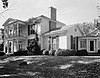
Longwood
|
 Longwood Longwood
|
September 15, 1976
(
#76001312
)
|
SW of Milton on NC 62
36°31′40″N
79°13′10″W
/
36.527778°N 79.219444°W
/
36.527778; -79.219444
(
Longwood
)
| Milton
|
|
| 10
|
James Malone House
|
Upload image
|
April 30, 2008
(
#08000367
)
|
7374 US 158
36°23′39″N
79°09′27″W
/
36.394056°N 79.1576°W
/
36.394056; -79.1576
(
James Malone House
)
| Leasburg
|
|
| 11
|
Melrose/Williamson House
|
 Melrose/Williamson House Melrose/Williamson House
|
February 28, 1985
(
#85000379
)
|
Off NC 62
36°25′42″N
79°17′51″W
/
36.428333°N 79.2975°W
/
36.428333; -79.2975
(
Melrose/Williamson House
)
| Yanceyville Township
|
|
| 12
|
Milton Historic District
|
 Milton Historic District Milton Historic District
|
October 25, 1973
(
#73001306
)
|
Runs along Main St. from Atlantic and Danville RR to County Line Creek
36°32′15″N
79°12′25″W
/
36.5375°N 79.206944°W
/
36.5375; -79.206944
(
Milton Historic District
)
| Milton
|
|
| 13
|
Milton State Bank
|
 Milton State Bank Milton State Bank
|
April 13, 1973
(
#73001307
)
|
Main (Broad) St.
36°32′20″N
79°12′21″W
/
36.538889°N 79.205833°W
/
36.538889; -79.205833
(
Milton State Bank
)
| Milton
|
|
| 14
|
Moore House
|
Upload image
|
August 28, 1973
(
#73001304
)
|
E of Locust Hill off U.S. 158
36°22′12″N
79°25′44″W
/
36.369986°N 79.428778°W
/
36.369986; -79.428778
(
Moore House
)
| Locust Hill
|
|
| 15
|
Poteat House
|
 Poteat House Poteat House
|
October 24, 1979
(
#79001688
)
|
N of Yanceyville on NC 62
36°25′11″N
79°18′37″W
/
36.419722°N 79.310278°W
/
36.419722; -79.310278
(
Poteat House
)
| Yanceyville
|
|
| 16
|
Red House Presbyterian Church
|
 Red House Presbyterian Church Red House Presbyterian Church
|
May 1, 2007
(
#07000413
)
|
13409 NC 119 N
36°29′15″N
79°09′46″W
/
36.487500°N 79.162778°W
/
36.487500; -79.162778
(
Red House Presbyterian Church
)
| Semora
|
|
| 17
|
Rose Hill
|
 Rose Hill Rose Hill
|
October 25, 1973
(
#73001305
)
|
On U.S. 158 at jct. with NC 150
36°22′22″N
79°25′59″W
/
36.372778°N 79.433153°W
/
36.372778; -79.433153
(
Rose Hill
)
| Locust Hill
|
|
| 18
|
Nicholas and Lucretia Thompson House
|
Upload image
|
December 8, 2022
(
#100008468
)
|
7846
US 158
East
36°23′09″N
79°07′42″W
/
36.3857°N 79.1284°W
/
36.3857; -79.1284
(
Nicholas and Lucretia Thompson House
)
| Leasburg
|
|
| 19
|
Union Tavern
|
 Union Tavern Union Tavern
|
May 15, 1975
(
#75001245
)
|
Main St.
36°32′18″N
79°12′24″W
/
36.538333°N 79.206667°W
/
36.538333; -79.206667
(
Union Tavern
)
| Milton
|
|
| 20
|
Warren House and Warren's Store
|
 Warren House and Warren's Store Warren House and Warren's Store
|
June 19, 1973
(
#73001308
)
|
On NC 86
36°14′56″N
79°11′24″W
/
36.248889°N 79.190000°W
/
36.248889; -79.190000
(
Warren House and Warren's Store
)
| Prospect Hill
|
|
| 21
|
Wemple-Shelton House
|
Upload image
|
August 8, 2023
(
#100009231
)
|
2215
US 158
West
36°24′23″N
79°23′05″W
/
36.4063°N 79.3847°W
/
36.4063; -79.3847
(
Wemple-Shelton House
)
| Yanceyville
vicinity
|
|
| 22
|
Wildwood
|
 Wildwood Wildwood
|
October 5, 2001
(
#01001076
)
|
5680 Stephentown Rd.
36°27′20″N
79°11′47″W
/
36.455556°N 79.196389°W
/
36.455556; -79.196389
(
Wildwood
)
| Semora
|
|
| 23
|
Woodside
|
 Woodside Woodside
|
March 6, 1986
(
#86000420
)
|
NC 57
36°31′33″N
79°10′58″W
/
36.525833°N 79.182778°W
/
36.525833; -79.182778
(
Woodside
)
| Milton
|
|
| 24
|
Bartlett Yancey House
|
 Bartlett Yancey House Bartlett Yancey House
|
December 4, 1973
(
#73001310
)
|
Southern side of
U.S. Route 158
, 0.3 miles west of the
NC 1500
junction
[6]
36°24′58″N
79°21′45″W
/
36.416111°N 79.362500°W
/
36.416111; -79.362500
(
Bartlett Yancey House
)
| Yanceyville
|
|
| 25
|
Yanceyville Historic District
|
 Yanceyville Historic District Yanceyville Historic District
|
October 15, 1973
(
#73001311
)
|
W. Main St., Courthouse Sq., and North Ave. to Church St.
36°24′19″N
79°20′27″W
/
36.405278°N 79.340833°W
/
36.405278; -79.340833
(
Yanceyville Historic District
)
| Yanceyville
|
|
See also
[
edit
]
References
[
edit
]
- ^
The latitude and longitude information provided in this table was derived originally from the National Register Information System, which has been found to be fairly accurate for about 99% of listings. Some locations in this table may have been corrected to current GPS standards.
- ^
National Park Service,
United States Department of the Interior
,
"National Register of Historic Places: Weekly List Actions"
, retrieved June 14, 2024.
- ^
Numbers represent an alphabetical ordering by significant words. Various colorings, defined
here
, differentiate
National Historic Landmarks
and
historic districts
from other NRHP buildings, structures, sites or objects.
- ^
"National Register Information System"
.
National Register of Historic Places
.
National Park Service
. April 24, 2008.
- ^
The eight-digit number below each date is the number assigned to each location in the
National Register Information System
database, which can be viewed by clicking the number.
- ^
Survey and Planning Unit, North Carolina Division of Archives and History.
National Register of Historic Places Inventory/Nomination: Bartlett Yancey House
. National Park Service, 1973-09-13. Accessed 2016-11-03.
|
|---|
| Topics
| | |
|---|
Lists
by county
| |
|---|
| Other lists
| |
|---|
|
|---|
| Topics
| |
|---|
| Lists by state
| |
|---|
| Lists by insular areas
| |
|---|
| Lists by associated state
| |
|---|
| Other areas
| |
|---|
| Related
| |
|---|
|
