From Wikipedia, the free encyclopedia
 Location of Calhoun County in South Carolina
This is a list of the
National Register of Historic Places listings in Calhoun County, South Carolina
.
This is intended to be a complete list of the properties on the
National Register of Historic Places
in
Calhoun County
,
South Carolina
,
United States
. The locations of National Register properties for which the latitude and longitude coordinates are included below, may be seen in a map.
[1]
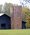
There are 18 properties listed on the National Register in the county.
This
National Park Service
list is complete through
NPS recent listings
posted June 14, 2024.
[2]
Current listings
[
edit
]
| [3]
|
Name on the Register
[4]
|
Image
|
Date listed
[5]
|
Location
| City or town
|
Description
|
| 1
|
William Baker House
|
 William Baker House William Baker House
|
March 8, 1978
(
#78002494
)
|
East of Gaston off
U.S. Route 21
33°49′50″N
80°59′46″W
/
33.830556°N 80.996111°W
/
33.830556; -80.996111
(
William Baker House
)
| Gaston
|
|
| 2
|
Col. J.A. Banks House
|
 Col. J.A. Banks House Col. J.A. Banks House
|
November 24, 1980
(
#80003655
)
|
104 Dantzler St.
33°39′45″N
80°46′42″W
/
33.6625°N 80.778333°W
/
33.6625; -80.778333
(
Col. J.A. Banks House
)
| St. Matthews
|
|
| 3
|
Buyck's Bluff Archeological Site
|
Upload image
|
May 4, 1979
(
#79002376
)
|
Address Restricted
| St. Matthews
|
|
| 4
|
Calhoun County Courthouse
|
 Calhoun County Courthouse Calhoun County Courthouse
|
October 30, 1981
(
#81000561
)
|
S. Railroad Ave.
33°39′47″N
80°46′46″W
/
33.663056°N 80.779444°W
/
33.663056; -80.779444
(
Calhoun County Courthouse
)
| St. Matthews
|
|
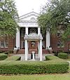
| 5
|
Calhoun County Library
|
 Calhoun County Library Calhoun County Library
|
May 29, 1975
(
#75001690
)
|
Railroad Ave.
33°40′01″N
80°46′28″W
/
33.666944°N 80.774444°W
/
33.666944; -80.774444
(
Calhoun County Library
)
| St. Matthews
|
|
| 6
|
Cherokee Path, Sterling Land Grant
|
Upload image
|
May 13, 1976
(
#76001696
)
|
5 miles southeast of St. Matthews on
South Carolina Highway 6
33°38′11″N
80°42′28″W
/
33.636389°N 80.707778°W
/
33.636389; -80.707778
(
Cherokee Path, Sterling Land Grant
)
| St. Matthews
|
|
| 7
|
Culclasure-Geiger Farmstead
|
Upload image
|
May 26, 2023
(
#100008999
)
|
1250 Great Circle Dr.
33°44′56″N
80°53′03″W
/
33.7489°N 80.8842°W
/
33.7489; -80.8842
(
Culclasure-Geiger Farmstead
)
| St. Matthews
vicinity
|
|
| 8
|
Col. Olin M. Dantzler House
|
 Col. Olin M. Dantzler House Col. Olin M. Dantzler House
|
March 30, 1973
(
#73001680
)
|
412 E. Bridge St.
33°39′42″N
80°46′26″W
/
33.6616°N 80.7740°W
/
33.6616; -80.7740
(
Col. Olin M. Dantzler House
)
| St. Matthews
|
|
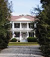
| 9
|
Fort Motte Battle Site
|
Upload image
|
November 9, 1972
(
#72001195
)
|
Address Restricted
| Fort Motte
|
|
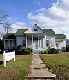
| 10
|
Haigler House
|
 Haigler House Haigler House
|
October 12, 2001
(
#01001099
)
|
Winding Brook Dr.
33°33′45″N
80°40′52″W
/
33.562454°N 80.6812°W
/
33.562454; -80.6812
(
Haigler House
)
| Cameron
|
|
| 11
|
David Houser House
|
 David Houser House David Houser House
|
November 25, 1980
(
#80003656
)
|
West of St. Matthews on
U.S. Route 176
33°40′37″N
80°50′08″W
/
33.676944°N 80.835556°W
/
33.676944; -80.835556
(
David Houser House
)
| St. Matthews
|
|
| 12
|
Lang Syne Plantation
|
Upload image
|
July 18, 2014
(
#14000429
)
|
Address Restricted
| St. Matthews
vicinity
|
|
| 13
|
Midway Plantation
|
 Midway Plantation Midway Plantation
|
May 28, 1976
(
#76001694
)
|
South of Fort Motte off
U.S. Route 601
33°40′31″N
80°41′39″W
/
33.675278°N 80.694167°W
/
33.675278; -80.694167
(
Midway Plantation
)
| Fort Motte
|
|
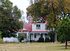
| 14
|
Oakland Plantation
|
 Oakland Plantation Oakland Plantation
|
May 30, 1975
(
#75001689
)
|
South of Fort Motte
33°41′12″N
80°40′00″W
/
33.686667°N 80.666667°W
/
33.686667; -80.666667
(
Oakland Plantation
)
| Fort Motte
|
|
| 15
|
Prehistoric Indian Village
|
 Prehistoric Indian Village Prehistoric Indian Village
|
July 30, 1974
(
#74001828
)
|
Address Restricted
| St. Matthews
|
|
| 16
|
Puritan Farm
|
 Puritan Farm Puritan Farm
|
July 25, 1974
(
#74001829
)
|
West of St. Matthews
33°39′48″N
80°48′56″W
/
33.663333°N 80.815556°W
/
33.663333; -80.815556
(
Puritan Farm
)
| St. Matthews
|
|
| 17
|
Ulmer-Summers House
|
 Ulmer-Summers House Ulmer-Summers House
|
October 25, 1973
(
#73001679
)
|
Old Orangeburg Rd. (
South Carolina Highway 31
)
33°33′44″N
80°42′55″W
/
33.562222°N 80.715278°W
/
33.562222; -80.715278
(
Ulmer-Summers House
)
| Cameron
|
|
| 18
|
Zante Plantation
|
 Zante Plantation Zante Plantation
|
June 29, 1976
(
#76001695
)
|
Southeast of Fort Motte off
South Carolina Highway 601
33°42′37″N
80°38′32″W
/
33.710278°N 80.642222°W
/
33.710278; -80.642222
(
Zante Plantation
)
| Fort Motte
|
|
See also
[
edit
]
References
[
edit
]
- ^
The latitude and longitude information provided in this table was derived originally from the National Register Information System, which has been found to be fairly accurate for about 99% of listings. Some locations in this table may have been corrected to current GPS standards.
- ^
National Park Service,
United States Department of the Interior
,
"National Register of Historic Places: Weekly List Actions"
, retrieved June 14, 2024.
- ^
Numbers represent an alphabetical ordering by significant words. Various colorings, defined
here
, differentiate
National Historic Landmarks
and
historic districts
from other NRHP buildings, structures, sites or objects.
- ^
"National Register Information System"
.
National Register of Historic Places
.
National Park Service
. March 13, 2009.
- ^
The eight-digit number below each date is the number assigned to each location in the
National Register Information System
database, which can be viewed by clicking the number.
|
|---|
| Topics
| | |
|---|
Lists
by county
| |
|---|
| Lists by city
| |
|---|
| Other lists
| |
|---|
|
