| [3]
|
Name on the Register
[4]
|
Image
|
Date listed
[5]
|
Location
| City or town
|
Description
|
| 1
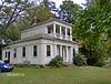
|
Ashtabula County Courthouse Group
|
 Ashtabula County Courthouse Group Ashtabula County Courthouse Group
|
June 30, 1975
(
#75001316
)
|
Northwestern corner of Jefferson and Chestnut Sts.
41°44′19″N
80°46′12″W
/
41.7386°N 80.77°W
/
41.7386; -80.77
(
Ashtabula County Courthouse Group
)
| Jefferson
|
|
| 2
|
Ashtabula Harbor Light
|
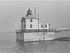 Ashtabula Harbor Light Ashtabula Harbor Light
|
August 4, 1983
(
#83001943
)
|
Ashtabula Harbor
41°55′06″N
80°47′45″W
/
41.9183°N 80.7958°W
/
41.9183; -80.7958
(
Ashtabula Harbor Light
)
| Ashtabula
|
|
| 3
|
Ashtabula Harbour Commercial District
|
 Ashtabula Harbour Commercial District Ashtabula Harbour Commercial District
|
September 5, 1975
(
#75001311
)
|
Both sides of W. 5th St. from its 1200 block to the
Ashtabula River
41°53′58″N
80°47′59″W
/
41.8994°N 80.7997°W
/
41.8994; -80.7997
(
Ashtabula Harbour Commercial District
)
| Ashtabula
|
|
| 4
|
Ashtabula Main Avenue Historic District
|
Upload image
|
August 27, 2020
(
#100005467
)
|
Roughly bounded by Park Pl., Collins Blvd., West 48th St., Center St., and Park Ave.
41°51′56″N
80°46′56″W
/
41.8656°N 80.7822°W
/
41.8656; -80.7822
(
Ashtabula Main Avenue Historic District
)
| Ashtabula
|
|
| 5
|
Ashtabula Post Office and Federal Building
|
Upload image
|
June 17, 2019
(
#100004053
)
|
4400 Main Ave.
41°52′02″N
80°46′53″W
/
41.8672°N 80.7814°W
/
41.8672; -80.7814
(
Ashtabula Post Office and Federal Building
)
| Ashtabula
|
|
| 6
|
Eliphalet Austin House
|
 Eliphalet Austin House Eliphalet Austin House
|
February 24, 1975
(
#75001313
)
|
1879
State Route 45
in Austinburg
41°46′31″N
80°51′19″W
/
41.7753°N 80.8553°W
/
41.7753; -80.8553
(
Eliphalet Austin House
)
| Austinburg Township
|
|
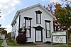
| 7
|
Blakeslee Log Cabin
|
 Blakeslee Log Cabin Blakeslee Log Cabin
|
April 1, 1998
(
#98000319
)
|
441 Seven Hills Rd., south of Ashtabula
41°50′41″N
80°46′09″W
/
41.8447°N 80.7692°W
/
41.8447; -80.7692
(
Blakeslee Log Cabin
)
| Plymouth Township
|
|
| 8
|
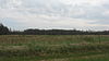
Boice Fort and Village Site
|
 Boice Fort and Village Site Boice Fort and Village Site
|
July 24, 1974
(
#74001398
)
|
Western side of Pymatuning Creek, near Wayne
[6]
41°32′25″N
80°38′10″W
/
41.5403°N 80.6361°W
/
41.5403; -80.6361
(
Boice Fort and Village Site
)
| Wayne Township
|
|
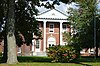
| 9
|
Michael Cahill House
|
 Michael Cahill House Michael Cahill House
|
October 5, 1988
(
#88001711
)
|
1106 Walnut Boulevard
41°54′04″N
80°48′01″W
/
41.9011°N 80.8004°W
/
41.9011; -80.8004
(
Michael Cahill House
)
| Ashtabula
|
Bed and breakfast
since 1986
|
| 10
|
Castle Block
|
Upload image
|
March 26, 2020
(
#100005127
)
|
323-355 Center St.
41°51′54″N
80°47′07″W
/
41.8649°N 80.7852°W
/
41.8649; -80.7852
(
Castle Block
)
| Ashtabula
|
|
| 11
|
The Cleveland Hotel
|
 The Cleveland Hotel The Cleveland Hotel
|
December 20, 2007
(
#07001294
)
|
230-238 State St.
41°56′39″N
80°33′18″W
/
41.9441°N 80.5551°W
/
41.9441; -80.5551
(
The Cleveland Hotel
)
| Conneaut
|
|
| 12
|
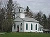
Congregational Church of Austinburg
|
 Congregational Church of Austinburg Congregational Church of Austinburg
|
December 22, 1978
(
#78002001
)
|
State Route 307
in Austinburg
41°46′17″N
80°51′22″W
/
41.7714°N 80.8561°W
/
41.7714; -80.8561
(
Congregational Church of Austinburg
)
| Austinburg Township
|
|
| 13
|
Conneaut Harbor West Breakwater Light
|
 Conneaut Harbor West Breakwater Light Conneaut Harbor West Breakwater Light
|
April 10, 1992
(
#92000243
)
|
Western breakwater pierhead at the harbor entrance
41°58′47″N
80°33′29″W
/
41.9797°N 80.5581°W
/
41.9797; -80.5581
(
Conneaut Harbor West Breakwater Light
)
| Conneaut
|
|
| 14
|
Conneaut Light Station Keeper's Dwelling
|
 Conneaut Light Station Keeper's Dwelling Conneaut Light Station Keeper's Dwelling
|
August 21, 1992
(
#92001078
)
|
1059 Harbor St.
41°58′01″N
80°33′07″W
/
41.9669°N 80.5519°W
/
41.9669; -80.5519
(
Conneaut Light Station Keeper's Dwelling
)
| Conneaut
|
|
| 15
|
Conneaut Works
|
 Conneaut Works Conneaut Works
|
July 30, 1974
(
#74001393
)
|
Off Mill Rd.
[7]
41°56′13″N
80°34′11″W
/
41.9370°N 80.5697°W
/
41.9370; -80.5697
(
Conneaut Works
)
| Conneaut
|
|
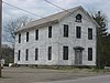
| 16
|
David Cummins Octagon House
|
 David Cummins Octagon House David Cummins Octagon House
|
September 9, 1974
(
#74001394
)
|
301 Liberty St.
41°56′28″N
80°33′26″W
/
41.9411°N 80.5572°W
/
41.9411; -80.5572
(
David Cummins Octagon House
)
| Conneaut
|
|
| 17
|
Eagle Cliff Hotel
|
 Eagle Cliff Hotel Eagle Cliff Hotel
|
October 20, 1995
(
#95001197
)
|
5254 Lake Rd., E.
41°51′40″N
80°56′40″W
/
41.8611°N 80.9444°W
/
41.8611; -80.9444
(
Eagle Cliff Hotel
)
| Geneva-on-the-Lake
|
|
| 18
|
Joshua Reed Giddings Law Office
|
 Joshua Reed Giddings Law Office Joshua Reed Giddings Law Office
|
May 30, 1974
(
#74001396
)
|
112 N. Chestnut St.
41°44′26″N
80°46′09″W
/
41.7406°N 80.7692°W
/
41.7406; -80.7692
(
Joshua Reed Giddings Law Office
)
| Jefferson
|
|
| 19
|
Griggs Grange No. 1467
|
 Griggs Grange No. 1467 Griggs Grange No. 1467
|
December 13, 1995
(
#95001414
)
|
1467 Brown Rd., north of Jefferson
41°47′19″N
80°42′47″W
/
41.7886°N 80.7131°W
/
41.7886; -80.7131
(
Griggs Grange No. 1467
)
| Plymouth Township
|
|
| 20
|
Francis E. Harmon House
|
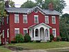 Francis E. Harmon House Francis E. Harmon House
|
February 24, 1975
(
#75001312
)
|
1641 E. Prospect Rd.
41°52′28″N
80°46′32″W
/
41.8744°N 80.7756°W
/
41.8744; -80.7756
(
Francis E. Harmon House
)
| Ashtabula
|
|
| 21
|
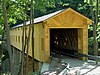
Harpersfield Covered Bridge
|
 Harpersfield Covered Bridge Harpersfield Covered Bridge
|
November 3, 1975
(
#75001315
)
|
County Road 154 over the
Grand River
41°45′22″N
80°56′40″W
/
41.7561°N 80.9444°W
/
41.7561; -80.9444
(
Harpersfield Covered Bridge
)
| Harpersfield Township
|
|
| 22
|
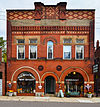
Harwood Block
|
 Harwood Block Harwood Block
|
March 21, 1978
(
#78002002
)
|
246, 250, and 256 Main St.
41°56′39″N
80°33′21″W
/
41.944167°N 80.555833°W
/
41.944167; -80.555833
(
Harwood Block
)
| Conneaut
|
|
| 23
|
John Henderson House
|
 John Henderson House John Henderson House
|
November 7, 1976
(
#76001368
)
|
5248 Stanhope-Kelloggsville Rd. in West Andover
41°36′28″N
80°36′44″W
/
41.607778°N 80.612222°W
/
41.607778; -80.612222
(
John Henderson House
)
| Andover Township
|
|
| 24
|
Hotel Ashtabula
|
 Hotel Ashtabula Hotel Ashtabula
|
June 20, 1985
(
#85001342
)
|
4726 Main Ave.
41°51′50″N
80°46′58″W
/
41.863889°N 80.782778°W
/
41.863889; -80.782778
(
Hotel Ashtabula
)
| Ashtabula
|
|
| 25
|
Col. Erastus House House
|
 Col. Erastus House House Col. Erastus House House
|
July 30, 1974
(
#74001397
)
|
State Route 46
and Richmond-Footville Rd. at Rays Corner
41°41′00″N
80°46′51″W
/
41.683472°N 80.780833°W
/
41.683472; -80.780833
(
Col. Erastus House House
)
| Lenox Township
|
|
| 26
|
Col. William Hubbard House
|
 Col. William Hubbard House Col. William Hubbard House
|
March 20, 1973
(
#73001385
)
|
Corner of Lake Ave. and Walnut Boulevard
41°53′59″N
80°48′17″W
/
41.899722°N 80.804722°W
/
41.899722; -80.804722
(
Col. William Hubbard House
)
| Ashtabula
|
|
| 27
|
Jefferson Town Hall
|
 Jefferson Town Hall Jefferson Town Hall
|
June 18, 1981
(
#81000428
)
|
27 E. Jefferson St.
41°44′19″N
80°46′05″W
/
41.738611°N 80.768056°W
/
41.738611; -80.768056
(
Jefferson Town Hall
)
| Jefferson
|
|
| 28
|
Kilpi Hall
|
 Kilpi Hall Kilpi Hall
|
December 12, 1976
(
#76001365
)
|
1025 Buffalo St.
41°57′55″N
80°33′19″W
/
41.965278°N 80.555278°W
/
41.965278; -80.555278
(
Kilpi Hall
)
| Conneaut
|
|
| 29
|
Lake Shore & Michigan Southern Railroad Station
|
 Lake Shore & Michigan Southern Railroad Station Lake Shore & Michigan Southern Railroad Station
|
October 14, 1982
(
#82001357
)
|
147 E. Jefferson St.
41°44′21″N
80°45′43″W
/
41.739167°N 80.761944°W
/
41.739167; -80.761944
(
Lake Shore & Michigan Southern Railroad Station
)
| Jefferson
|
|
| 30
|
Lake Shore And Michigan Southern Passenger Depot
|
 Lake Shore And Michigan Southern Passenger Depot Lake Shore And Michigan Southern Passenger Depot
|
March 27, 1975
(
#75001314
)
|
342 Depot St.
41°56′59″N
80°33′33″W
/
41.949722°N 80.559167°W
/
41.949722; -80.559167
(
Lake Shore And Michigan Southern Passenger Depot
)
| Conneaut
|
|
| 31
|
Mother of Sorrows Church
|
 Mother of Sorrows Church Mother of Sorrows Church
|
March 9, 1995
(
#95000170
)
|
1500 W. 6th St.
41°53′45″N
80°48′13″W
/
41.895833°N 80.803611°W
/
41.895833; -80.803611
(
Mother of Sorrows Church
)
| Ashtabula
|
|
| 32
|
New Lyme Institute
|
 New Lyme Institute New Lyme Institute
|
January 1, 1976
(
#76001367
)
|
929 Brownville Rd. in South New Lyme
41°34′57″N
80°47′02″W
/
41.582500°N 80.783889°W
/
41.582500; -80.783889
(
New Lyme Institute
)
| New Lyme Township
|
|
| 33
|
New Lyme Town Hall
|
 New Lyme Town Hall New Lyme Town Hall
|
August 6, 1975
(
#75001317
)
|
North of South New Lyme at 6000
State Route 46
41°35′09″N
80°46′42″W
/
41.585972°N 80.778333°W
/
41.585972; -80.778333
(
New Lyme Town Hall
)
| New Lyme Township
|
|
| 34
|
L. W. Peck House
|
 L. W. Peck House L. W. Peck House
|
January 1, 1976
(
#76001366
)
|
2646 Eagleville Rd. in Eagleville
41°42′54″N
80°50′48″W
/
41.715°N 80.846667°W
/
41.715; -80.846667
(
L. W. Peck House
)
| Austinburg Township
|
|
| 35
|
Rock Creek School
|
 Rock Creek School Rock Creek School
|
February 9, 2005
(
#05000023
)
|
2987 High St.
41°39′46″N
80°51′28″W
/
41.662778°N 80.857778°W
/
41.662778; -80.857778
(
Rock Creek School
)
| Rock Creek
|
|
| 36
|
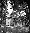
Shandy Hall
|
 Shandy Hall Shandy Hall
|
June 28, 1974
(
#74001395
)
|
6333 S. Ridge Rd., southwest of Geneva
41°46′55″N
80°58′57″W
/
41.781944°N 80.982500°W
/
41.781944; -80.982500
(
Shandy Hall
)
| Harpersfield Township
|
|
| 37
|
West Fifth Street Bridge
|
 West Fifth Street Bridge West Fifth Street Bridge
|
August 23, 1985
(
#85001801
)
|
State Route 531
over the
Ashtabula River
41°54′01″N
80°47′53″W
/
41.900278°N 80.798056°W
/
41.900278; -80.798056
(
West Fifth Street Bridge
)
| Ashtabula
|
|
| 38
|
Windsor Corners District
|
 Windsor Corners District Windsor Corners District
|
September 5, 1975
(
#75001318
)
|
U.S. Route 322
and
State Route 534
in Windsor
41°32′07″N
80°56′04″W
/
41.535256°N 80.934422°W
/
41.535256; -80.934422
(
Windsor Corners District
)
| Windsor Township
|
|
| 39
|
Windsor Mills Christ Church Episcopal
|
 Windsor Mills Christ Church Episcopal Windsor Mills Christ Church Episcopal
|
May 29, 1975
(
#75001319
)
|
Wisell Rd. and
U.S. Route 322
at Windsor Mills
41°32′09″N
80°57′43″W
/
41.535833°N 80.961944°W
/
41.535833; -80.961944
(
Windsor Mills Christ Church Episcopal
)
| Windsor Township
|
|
| 40
|
Windsor Mills Fort and Village Site
|
 Windsor Mills Fort and Village Site Windsor Mills Fort and Village Site
|
October 21, 1975
(
#75001321
)
|
Off
U.S. Route 322
, southeast of Windsor Mills
[8]
41°31′53″N
80°58′30″W
/
41.531389°N 80.975000°W
/
41.531389; -80.975000
(
Windsor Mills Fort and Village Site
)
| Windsor Township
|
|
| 41
|
Wiswell Road Covered Bridge
|
 Wiswell Road Covered Bridge Wiswell Road Covered Bridge
|
April 11, 1973
(
#73001386
)
|
Wiswell Rd. over Phelps Creek at Windsor Mills
41°31′59″N
80°57′50″W
/
41.533056°N 80.963889°W
/
41.533056; -80.963889
(
Wiswell Road Covered Bridge
)
| Windsor Township
|
|