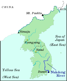
Longest river in South Korea
| Nakdong River
|
|---|
 |
 The Nakdonggang River
|
| Native name
| 洛東江
(
Korean
)
|
|---|
|
| Country
| South Korea
|
|---|
| Provinces
| Gangwon
,
North Gyeongsang
,
Daegu
,
South Gyeongsang
,
Busan
|
|---|
|
|
| Source
| Taebaek Mountains
|
|---|
| • location
| Eundae Peak,
Taebaek
,
Gangwon
[a]
[1]
|
|---|
|
|
| Mouth
| Sea of Japan
|
|---|
• location
| Estuary Bank,
Gangseo
,
Busan
|
|---|
| Length
| 510 km (320 mi)
[2]
|
|---|
| Basin size
| 23,384 km
2
(9,029 sq mi)
[2]
|
|---|
|
| Discharge
|
|
|---|
| • location
| Jindong, Haman
[b]
[3]
|
|---|
| • average
| 383 m
3
/s (13,500 cu ft/s)
[c]
[3]
|
|---|
|
|
|
| Tributaries
|
|
|---|
| • left
| Banbyeoncheon,
Geumhogang River
,
Miryanggang River
, Yangsancheon,
West Nakdonggang River
†
|
|---|
| • right
| Naeseongcheon, Gamcheon,
Hwanggang River
,
Nam River
|
|---|
| † : Distributary of Nakdonggang
|
The
Nakdong River
or
Nakdonggang
(
Korean
:
洛東江
,
pronounced
[nak?t?oŋgaŋ]
)
[d]
is the longest
river
in
South Korea
, which passes through the major cities of
Daegu
and
Busan
. It takes its name from its role as the eastern border of the
Gaya confederacy
during
Korea's Three Kingdoms Era
.
Geography
[
edit
]
The Nakdong River flows from the
Taebaek Mountains
to the South Sea or
Korea Strait
, which separates Korea from Japan. The river originates from the junction of the Cheolamcheon and Hwangjicheon streams in Dongjeom-dong,
Taebaek
,
Gangwon Province
. From there to its
mouth
it winds for about 506 kilometres (314 mi). The width of the river ranges from only a few metres in its upper reaches to several hundred metres towards its
estuary
.
Major tributaries include the
Yeong
,
Geumho
, and
Nam
rivers. Together with its
tributaries
, the Nakdonggang drains most of
North Gyeongsang
and
South Gyeongsang
provinces, along with small portions of
North Jeolla
,
South Jeolla
, and Gangwon provinces. The total
watershed
is 23,384 square kilometres (9,029 sq mi).
History
[
edit
]
 Hahoe Folk Village
The Nakdong has played an important role throughout
Korean history
. The
river basin
has been a favored dwelling-place for as long as people have inhabited the
Korean peninsula
. Numerous
Neolithic
remains have been found in the valley.
Around the 1st century, the valley is believed to have been inhabited by the
Byeonhan confederacy
tribes. During the
Three Kingdoms period
, the
Gaya confederacy
controlled the valley until they were overrun by
Silla
in 562. These states exploited the river's potential for navigation and commerce, operating a thriving trade in armor and weapons with neighboring countries, including
Yamato period
Japan. Through the Silla,
Goryeo
, and
Joseon
periods, the river continued to serve as a major transportation corridor in the
Gyeongsang
region. It was especially used for transporting inland fresh seafood, such as
mackerel
, which were salted and dried to prevent them from spoiling. The city of
Andong
was the farthest inland the fish could be brought before going bad, so many people flocked there during the Joseon dynasty to eat fish.
[5]
As a barrier to movement, the Nakdong River gained sudden prominence during the
Korean War
. The southern length of the river formed the western portion of the
Pusan Perimeter
, which the UN forces fought to maintain during the autumn of 1950. The bridge at
Waegwan
was blown up on August 3, 1950, in an effort to prevent
North Korean
forces from advancing on
Daegu
. A large number of South Korean
refugees
were killed in the explosion.
[6]
Although some North Korean forces did cross the Nakdong River in places, for the most part the river marked their furthest advance.
Ecology
[
edit
]
The Nakdong River valley includes numerous floodplain wetlands, the most well-known of which are the Junamjeosuji Reservoir near
Changwon
and
Upo Wetland
in
Changnyeong County
. These wetlands, while significantly degraded and overdeveloped, provide habitat to a significant number of rare and threatened species, most especially birds (such as the
Baikal teal
and
White-naped crane
), fish and plants.
Despite being home to the bustling Port of
Busan
, the Nakdonggang estuary is internationally important for waterbirds, despite recent ecologically-destructive developments including reclamation for housing and industry (e.g. the Busan New Port), the ongoing construction of a major bridge (the Miyeonji Bridge) and most recently the threatened construction of the
Korean Grand Canal
project.
The Nakdonggang and its tributaries serve as a major source of
drinking water
for the inhabitants of the river basin and others nearby. However, water pollution from domestic and
agricultural wastewater
remains a serious concern.
Phenol contamination
[
edit
]
In 1991, there were two incidents where
phenol
was leaked into the river from
Doosan
Electronics. There were two leaks, the first thirty tons on March 14, 1991 and the second 1.3 tons on April 22. The phenol ended up at a water processing facility used for drinking water in Daegu and began to smell after converting to
chlorophenol
when the water was sanitized with
chlorine
.
Economic role
[
edit
]
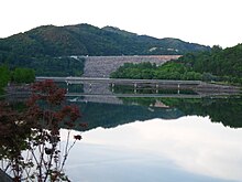
Andong Dam
Although all but the southernmost reaches of the Nakdonggang River have ceased to serve as a major commercial waterway, the river continues to feed those dwelling near it, both directly through fishing and indirectly through irrigation. Substantial amounts of snails and catfish are taken from the waters and used in local cuisine.
Near
Andong
, a series of massive hydroelectric dams have been constructed, creating a small chain of artificial lakes of which
Andong Lake
is the largest. These lakes also support a substantial recreational industry. Bass fishing is especially popular, since the lakes have been artificially stocked with
bass
.
In the early 2010s, the Nakdonggang River was to be part of President
Lee Myung-bak
's canal project, the
Grand Korean Waterway
. The project would link the Nakdong with the Han River to the north, creating a shipping canal spanning length of the country, from Seoul to Busan. Encountering considerable controversy nationwide as well as from residents along the Nakdonggang, the waterway project was scrapped by the end of Lee's presidency.
Festival
[
edit
]
The Nakdong River Cultural Center holds bicycle festivals that everyone can enjoy the healthy leisure culture of local residents. It is composed of flat courses about 20 km in the vicinity of Eulsukdo and Nakdonggang River Cultural Center.
[7]
See also
[
edit
]
Notes
[
edit
]
- ^
Eundae Peak
(1,442.3m,
Korean
:
銀대봉
;
Hanja
:
銀臺峰
;
RR
:
Eundaebong
. The peak is also known as the
Sanghambaek Mountain
(上함백산) or
Cheonui Peak
(천의봉).)
- ^
Discharge average from 2004 to 2013.
- ^
Discharge average from 2004 to 2013.
- ^
In the 19th century, it was also known in English sources as
Nam-tong River
or
Nam-tong Kang
.
The name was romanized as
Naktong
during the
Korean War
.
References
[
edit
]
- ^
2013年 韓國河川一覽
[List of Rivers of South Korea, 2013]
(PDF)
(in Korean). Han River Flood Control Office, Republic of Korea. 31 December 2012. pp. 22, 25, 29, 136?137. Archived from
the original
(PDF)
on 4 March 2016
. Retrieved
7 July
2014
.
- ^
a
b
HRFCO 2012
Archived
2016-03-04 at the
Wayback Machine
, pp. 22, 25, 33, 136-137.
- ^
a
b
2014年 1月 月刊 水資源 現況 및 展望
[Monthly Status & Predictions Report on Water Resources, January 2014] (in Korean). Han River Flood Control Office, Republic of Korea. 13 January 2014. p. 3. Archived from
the original
(HWP)
on 15 July 2014
. Retrieved
17 July
2014
.
- ^
"Archived copy"
. Archived from
the original
on 2012-04-02
. Retrieved
2011-11-09
.
{{
cite web
}}
: CS1 maint: archived copy as title (
link
)
- ^
"1950"
Retrieved October 10, 2019
- ^
"洛東江自轉車페스티벌 2018"
.
korean.visitkorea.or.kr
(in Korean)
. Retrieved
2018-06-12
.
Bibliography
[
edit
]
- "Corea"
,
'
Encyclopædia Britannica
, 9th ed., Vol. VI
, New York: Charles Scribner's Sons, 1878, pp. 390?394
.
35°03′06″N
128°55′21″E
/
35.05167°N 128.92250°E
/
35.05167; 128.92250