City in West Bengal
City in West Bengal, India
Murshidabad
(
,
or
)
[a]
is a historical city in the
Indian
state
of
West Bengal
. It is located on the eastern bank of the
Bhagirathi River
, a distributary of the
Ganges
. It forms part of the
Murshidabad district
.
During the 18th century, Murshidabad was a prosperous city.
[5]
[6]
It was the capital of the
Bengal Subah
for seventy years, with a jurisdiction covering modern-day
Bangladesh
and the Indian states of West Bengal,
Bihar
and
Orissa
. It was the seat of the hereditary
Nawab of Bengal
and the state's treasury, revenue office and judiciary. Murshidabad was a cosmopolitan city. Its population peaked at 100,000 in the 1750s. It was home to wealthy banking and merchant families from different parts of the
Indian subcontinent
and wider
Eurasia
, including the
Jagat Seth
and
Armenians
.
European companies, including the
British East India Company
, the
French East India Company
, the
Dutch East India Company
and the
Danish East India Company
, conducted business and operated factories around the city.
Silk
was a major product of Murshidabad. The city was also a center of art and culture, including ivory sculptors,
Hindustani classical music
and the Murshidabad style of
Mughal painting
.
The city's decline began with the defeat of the last independent Nawab of Bengal
Siraj-ud-Daulah
at the
Battle of Plassey
in 1757. The Nawab was demoted to the status of a
zamindar
known as the
Nawab of Murshidabad
. The British shifted the treasury, courts and revenue office to
Calcutta
. In the 19th century, the population was estimated to be 46,000. Murshidabad became a district headquarters of the
Bengal Presidency
. It was declared as a municipality in 1869.
Etymology
[
edit
]
Murshidabad was named after its founder, Nawab
Murshid Quli Khan
.
Murshid
is an Arabic term for a teacher or guide with integrity, sensibility, and maturity. The suffix
-abad
is derived from the Persian word
abad
, which referred to a cultivated place.
Geography
[
edit
]

1.5km
1mile
Tripolia
Gate
T
Nashipur
railway bridge
F
Tomb of Azimunnisa Begum
H
House of Jagat Seth
H
Yellow Mosque
H
Bhagirathi River
Murshidabad
railway station
F
Nashipur Rajbari
H
Mir Jafar's Palace
H
Kathgola Palace
H
Fauti Mosque
H
Jama Masjid, Motijheel
H
Chawk Masjid
H
Katra Masjid
H
Jafaganj Cemetery
H
Wasif Manzil
H
Madina Mosque
H
Clock Tower
H
Nizamat Imambara
H
Hazarduari Palace
H
Murshidabad
F: facility, H: historical site
Owing to space constraints in the small map, the actual locations in a larger map may vary slightly
Location
[
edit
]
Murshidabad is located at
24°11′N
88°16′E
/
24.18°N 88.27°E
/
24.18; 88.27
.
Hazarduari Palace
and its associated sites in the Kila Nizamat area (forming the central area in the map alongside) is the centre of attraction in Murshidabad. Just a little away are
Katra Masjid
,
Fauti Mosque
,
Jama Masjid
and the
Motijhil
area. There is a group of attractions in the northern part of the town (as can be seen in the map alongside). Some attractions such as
Khushbagh
,
Rosnaiganj
,
Baranagar
,
Kiriteswari Temple
,
Karnasuvarna
and others are on the other side of the river and there are attractions in the neighbouring
Berhampore
area also (not shown in the map).
[7]
Note: The map alongside presents some of the notable locations in Murshidabad city. Most of the places marked in the map are linked in the larger full screen map. A few, without pages yet, remain unmarked. The map has a scale. It will help viewers to find out the distances.
History
[
edit
]
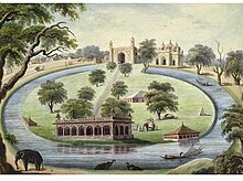 Painting of the garden, mosque and prince's pavilions in
Motijhil
(pearl lake)
Painting of the garden, mosque and prince's pavilions in
Motijhil
(pearl lake)
 Nawab
Alivardi Khan
with a courtier, painted in the
Company Style
, where it first emerged in Murshidabad
[8]
Nawab
Alivardi Khan
with a courtier, painted in the
Company Style
, where it first emerged in Murshidabad
[8]
 Illuminated Katgola Palace at night
 The Nawab's boats on a river
 A
Jain
temple in the mansion of
Jagat Seth
, a historically prominent banking family of Murshidabad
A
Jain
temple in the mansion of
Jagat Seth
, a historically prominent banking family of Murshidabad
The area was part of the
Gauda Kingdom
and
Vanga Kingdom
in
ancient Bengal
. The
Riyaz-us-Salatin
credited the initial development of the town to a merchant named Makhsus Khan. The merchant's role is also mentioned in the
Ain-i-Akbari
.
[9]
During the 17th-century, the area was well known for
sericulture
. In 1621, English agents reported that large quantities of silk were available in the area. During the 1660s, it became a
pargana
of the Mughal administration, with jurisdiction over European companies in
Cossimbazar
.
[9]
In the early 18th-century,
Murshid Quli Khan
, the prime minister of Bengal Subah, had a bitter rivalry with Prince
Azim-ush-Shan
, the viceroy of Bengal. The latter even attempted to have Khan killed.
[9]
The Mughal court in
Delhi
was also rapidly losing authority in much of the subcontinent. Amid the decline of the central government, the
Mughal Emperor
Farrukhsiyar
promoted Khan to the status of a princely
Nawab
. As Nawab, Khan was given the opportunity to create a princely dynasty as part of the Mughal aristocracy.
Murshid Quli Khan shifted the capital of Bengal from
Dhaka
, which lost its strategic importance after the expulsion of the
Arakanese
and
Portuguese
from
Chittagong
.
[9]
He founded the city of Murshidabad and named the city after himself. It became the center of political, economic and cultural life in Bengal. The jurisdiction of the Nawab included not only Bengal, but also Bihar and Orissa.
[10]
Murshidabad was also located centrally in the expanded jurisdiction of Bengal, Bihar and Orissa.
The presence of the princely court, the
Mughal Army
,
artisans
and multiethnic merchants increased the wealth of Murshidabad. Wealthy families and companies established their head offices in the city. The Murshidabad
mint
became the largest in Bengal, with a value amounting to two percent of the minted currency. The city witnessed the construction of administrative buildings, gardens, palaces, mosques, temples and mansions. European companies operated factories in the city's outskirts. The city was full of brokers, workers, peons, naibs, wakils, and ordinary traders.
[9]
Murshid Quli Khan transformed Murshidabad into a
capital city
with an efficient administrative machinery for his successors. He built a palace and a
caravanserai
with a grand mosque, known as the
Katra Masjid
. The main military base was located near the mosque and formed the city's eastern gateway. The third Nawab
Shuja-ud-Din Muhammad Khan
patronized the construction of another palace and military base, a new gateway, the revenue office, a public audience hall (
durbar
), a private chamber, the treasury and a mosque in an extensive compound called Farrabagh (Garden of Joy) which included canals,
fountains
, flowers, and fruit trees.
[9]
Nawab Siraj-ud-Daulah established a palace near the
Motijhil
(Pearl Lake). The
Nizamat Imambara
was built for
Shia Muslims
. The palace complex was fortified and known as the Nizamat Fort. The main entrances of the Nizamat Fort had musicians' galleries. The gates were high, imposing and tall enough for an elephant to pass through. The Khoshbagh garden was the burial place of the Nawabs.
[9]
The city had a
Bengali
majority population, including
Bengali Muslims
and
Bengali Hindus
. There was an influential
Jain
community involved in trade and commerce.
[10]
An
Armenian
community also settled and became financiers for the Nawab. The
Jagat Seth
were one of the prominent banking families of Murshidabad. They controlled
money lending
activities and served as financiers for administrators, merchants, traders, the Nawabs, the Zamindars, as well as the British, French, Armenians and Dutch. The merchants built many mansions, including the Azimganj Rajbati,
Kathgola
house and
Nashipur
house.
The Nawabs of Bengal entered into agreements with numerous European trading companies allowing them to establish bases in the region. The French East India Company operated factories in Murshidabad and Dhaka. The British East India Company was based in
Fort William
. Murshidabad was a part of the
Dutch Bengal
Department. The
Ostend Company
of
Austria
established a base near Murshidabad. The Danish East India Company also set up trading posts in the Bengal Subah.
The last independent Nawab Siraj-ud-Daulah was overthrown in 1757. Despite receiving assurances of French support, the Nawab was betrayed by his commander
Mir Jafar
. The British installed Mir Jafar's family as a puppet dynasty and eventually reduced the Nawab to the status of a landlord (zamindar). The British continued to collect revenue from the area's factories. The merchant families continued to prosper under
company rule in India
.
[10]
In 1858, the British government gained direct control of India's administration.
Murshidabad was very badly affected by the
Bengal Famine of 1770
.
[5]
Murshidabad was a district city of the
Bengal Presidency
.
Warren Hastings
removed the supreme civil and criminal courts to
Calcutta
in 1772, but in 1775 the latter courts were brought back to Murshidabad again. In 1790, under
Lord Cornwallis
, the entire revenue and judicial staffs were moved to Calcutta. The city was still the residence of the Nawab, who ranked as the first nobleman of the province with the style of
Nawab Bahadur of Murshidabad
, instead of
Nawab Nazim of Bengal
. The
Hazarduari Palace
was built in 1837 as a residence for both the Nawab and British civil servants. Murshidabad became a
municipality
in 1869. The population in 1901 was 15,168. The silk industry was revived with assistance from the government. The area also became notable for
mango
and
litchi
production.
[11]
See also -
Nawabs of Bengal and Murshidabad
- Art of Murshidabad
-
Two horsemen, Murshidabad style of painting
-
Woman playing the
sitar
, Murshidabad style of painting
-
Ivory sculpture of a royal barge
-
Ivory sculpture of a royal barge
-
An elevated musicians' gallery where drums, flutes and Indian classical music would be played.
Economy
[
edit
]
 Murshidabad District has several terracotta Bengali Hindu temples
The city today is a center for agriculture, handicrafts and
sericulture
. The famous
Murshidabad silk
, much in demand for making
saris
and scarves, is produced here.
[
citation needed
]
Demographics
[
edit
]
As of
2011 Indian Census
, Murshidabad had a total population of 44,019, of which 22,177 were males and 21,842 were females. Population within the age group of 0 to 6 years was 4,414. The total number of literates in Murshidabad was 32,451, which constituted 73.7% of the population with male literacy of 77.3% and female literacy of 70.1%. The effective literacy rate of 7+ population of Murshidabad was 81.9%, of which male literacy rate was 86.0% and female literacy rate was 77.9%. The
Scheduled Castes and Scheduled Tribes
population was 13,762 and 302 respectively. Murshidabad had 9829 households in 2011.According to 2011 census the religious make-up of Murshidabd city was: Hindus (75.09%), Muslims (23.86%) and others(1.05%)
[2]
Educational institutes
[
edit
]
Schools
[
edit
]
Colleges
[
edit
]
Medical schools
[
edit
]
Universities
[
edit
]
Murshidabad Heritage Festival
[
edit
]
 Dance performance in
Kathgola
gardens during the Murshidabad Heritage Festival
Dance performance in
Kathgola
gardens during the Murshidabad Heritage Festival
The Murshidabad Heritage Festival aims at reviving the tangible and intangible heritage of Murshidabad along with those nearby heritage tows of Azimganj, Jiaganj and Cossimbazar. The festival aims at preserving the past and integrating it with the present and to bring Murshidabad back in the tourism, cultural and heritage map of India. It is an initiative of Murshidabad Heritage Development Society (MHDS). The festival began in 2011 and has been celebrated ever since. There are no fixed days for the festival but it is celebrated during the winter season, especially during January or February. The festival is complete with cultural performances, heritage walks, cruise along the Bagirati River and exotic food. The Food served during the festival is purely vegetarian, with special emphasis on Sheherwali cuisine.
[12]
Notable residents
[
edit
]
Notes
[
edit
]
- ^
Earlier European spellings include Muxadavad, Murshedabud, Murshedabad, Murshedebad, Murshidabud, Murshidabad, Murshidebad, Mursedabad, Mursidabud, Mursidabad, Moorshedabud, Moorshedabad, Moorshedebad, Moorshidabad, Moorsedabad, Moorsidabad, Mourshedabad, Mourshedebad, Mourshidabad, Murschidabad, Murschedabad, Moorschedabad, and Moorschidabad, among others.
[
citation needed
]
References
[
edit
]
External links
[
edit
]
|
|---|
|
Cities
,
municipal
and
census
towns
| |  Divisions of West Bengal Divisions of West Bengal
|
|---|
Locations
other than cities and towns
| |
|---|
| Neighbourhoods
| |
|---|
| Related topics
| |
|---|
|
|
|---|
|
| General
| | Divisions of West Bengal
|
|---|
| History
| |
|---|
| Subdivisions
| |
|---|
| Municipalities
| |
|---|
Community development
blocks
| |
|---|
| Rivers
| |
|---|
| Transport
| |
|---|
| Railway stations
| |
|---|
| Institutes of higher learning
| |
|---|
| Lok Sabha constituencies
| |
|---|
| Vidhan Sabha constituencies
| |
|---|
Former
Vidhan Sabha constituencies
| |
|---|
| Villages
| |
|---|
| See also
| |
|---|
|
|---|
| Houses and palaces
| |
|---|
| Kathgola
| |
|---|
| Graves, mosques and tombs
| |
|---|
| Cannons
| |
|---|
| Temples
| |
|---|
| Archaeological sites
| |
|---|
| Others
| |
|---|
|