From Wikipedia, the free encyclopedia
Street in London, England
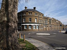 View looking eastwards from Mortlake Green including the wall of the old Mortlake Brewery
 The
Tudor
St Mary's Church
The
Tudor
St Mary's Church
 123 Mortlake High Street
, an eighteenth-century building which served as the town hall of the
Borough of Barnes
from 1895 to 1940
123 Mortlake High Street
, an eighteenth-century building which served as the town hall of the
Borough of Barnes
from 1895 to 1940
 Mortlake Green at the western end of the street
Mortlake High Street
is a street running through
Mortlake
in
west London
in England, United Kingdom. Located in the
London Borough of Richmond
, it is the historic
high street
of Mortlake dating back several centuries. It runs from east to west, beginning at
The Terrace, Barnes
and running parallel to the southern bank of the
River Thames
and finishing at Mortlake Green close to
Mortlake railway station
and the site of the former Mortlake Brewery. It forms part of the
A3003 road
.
Mortlake was celebrated for its
tapestry works
in the early
modern era
.
[1]
The High Street provided the historic centre of the local area, only being overshadowed by the later development of
East Sheen
a little to the south as the formerly rural area was developed during the urbanisation of London. Mortlake Railway Station opened in 1846 to provide Mortlake with trains to
Central London
while
Barnes Bridge railway station
, a little to the east of the high street, opened in 1916 on the
Hounslow Loop
. The architecture of the street is a mixture of different periods, including
Edwardian
and later twentieth century
apartments
alongside buildings such as the
Georgian
Grade II listed
house at 117 Mortlake High Street.
[2]
The
Anglican church
St Mary the Virgin
is located on the southern side of the street. The current building dates back to the
Tudor period
, but an earlier chapel existed from 1348.
[3]
The Prime Minister
Henry Addington
is buried in the churchyard.
[4]
The
Catholic church
St Mary Magdalen
is located a little further to the south on Worple Street. Built in 1852 in the
Gothic Revival
style it features the
tomb of Sir Richard Burton
, the noted explorer and writer.
[4]
The house at
123 Mortlake High Street
, at the eastern end of the street, was built in 1720. Historic residents have included
Lady Byron
and the Irish soldier
Sir Garnet Wolseley
. From 1895 to 1940 it served as the
town hall
of
Borough of Barnes
, until it was bombed during the
London Blitz
of 1940. It was painted in the early nineteenth century by
Turner
, and is now
Grade II* listed
.
[5]
From 1901 to 1959
Barnes power station
operated on the High Street. Now decommissioned, the building still stands on the street.
See also
[
edit
]
References
[
edit
]
Bibliography
[
edit
]
- Cherry, Bridget & Pevsner, Nikolaus.
London 2: South
. Yale University Press, 2002.
- Fisher, Stuart.
Rivers of Britain: Estuaries, Tideways, Havens, Lochs, Firths and Kyles
. A & C Black, 2012.
- Sloane, Barney Hoad, Stewart.
Early Modern Industry and Settlement: Excavations at George Street, Richmond, and High Street, Mortlake, in the London Borough of Richmond Upon Thames
. Museum of London Archaeology Service, 2003.
 Media related to
Mortlake High Street
at Wikimedia Commons
Media related to
Mortlake High Street
at Wikimedia Commons
|
|---|
| Districts
| | |
|---|
| Railway stations
| |
|---|
| Streets and roads
| |
|---|
River Thames bridges, islands
and river services
| |
|---|
| Other rivers and streams
| |
|---|
| Sports venues
| |
|---|
| Events
| |
|---|
| Breweries and pubs
|
- Britannia, Richmond
- The Bull's Head, Barnes
- The Crown, Twickenham
- Dysart Arms, Petersham
- The Fox, Twickenham
- The George, Twickenham
- Hare and Hounds, East Sheen
- Jolly Coopers, Hampton
- Old Ship, Richmond
- Park Hotel, Teddington
- Richmond Brewery Stores
- Sun Inn, Barnes
- Twickenham Fine Ales
- Watney Combe & Reid
- White Cross, Richmond
- The White Swan, Twickenham
|
|---|
Theatres, cinemas
and music venues
| |
|---|
| Film and recording studios
| |
|---|
| Media and publishing
| |
|---|
| Public art
| |
|---|
| Historical royal palaces
| |
|---|
Other places
of interest
| |
|---|
| Tragedy and disaster
| |
|---|
| Other history topics
| |
|---|
| Parliamentary constituencies
| |
|---|
| Other topics
| |
|---|
|
51°28′11″N
0°15′39″W
/
51.46986°N 0.26085°W
/
51.46986; -0.26085
