Type of satellite designed to record the state of the Earth's atmosphere
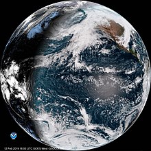
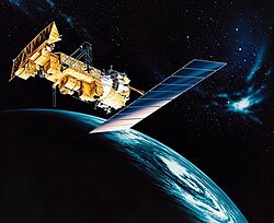
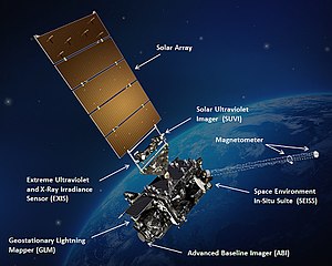 GOES-16, a United States weather satellite of the meteorological-satellite service
A
weather satellite
or
meteorological satellite
is a type of
Earth observation satellite
that is primarily used to monitor the
weather
and
climate
of the Earth. Satellites can be
polar orbiting
(covering the entire Earth asynchronously), or
geostationary
(hovering over the same spot on the
equator
).
[1]
While primarily used to detect the development and movement of storm systems and other cloud patterns,
meteorological
satellites can also detect other phenomena such as city lights, fires, effects of pollution,
auroras
, sand and
dust storms
, snow cover, ice mapping, boundaries of
ocean currents
, and energy flows. Other types of environmental information are collected using weather satellites. Weather satellite images helped in monitoring the volcanic ash cloud from
Mount St. Helens
and activity from other volcanoes such as
Mount Etna
.
[2]
Smoke from
fires
in the western United States such as
Colorado
and
Utah
have also been monitored.
El Nino
and its effects on weather are monitored daily from satellite images. The Antarctic
ozone hole
is mapped from weather satellite data. Collectively, weather satellites flown by the U.S., Europe, India, China, Russia, and Japan provide nearly continuous observations for a global weather watch.
History
[
edit
]
 The first television image of Earth from space from the TIROS-1 weather satellite in 1960
 A mosaic of photographs of the
United States
from the
ESSA-9
weather satellite, taken on June 26, 1969
A mosaic of photographs of the
United States
from the
ESSA-9
weather satellite, taken on June 26, 1969
As early as 1946, the idea of cameras in orbit to observe the weather was being developed. This was due to sparse data observation coverage and the expense of using cloud cameras on rockets. By 1958, the early prototypes for TIROS and Vanguard (developed by the Army Signal Corps) were created.
[3]
The first weather satellite,
Vanguard 2
, was launched on February 17, 1959.
[4]
It was designed to measure cloud cover and resistance, but a poor axis of rotation and its elliptical orbit kept it from collecting a notable amount of useful data. The Explorer VI and VII satellites also contained weather-related experiments.
[3]
The first weather satellite to be considered a success was
TIROS-1
, launched by NASA on April 1, 1960.
[5]
TIROS operated for 78 days and proved to be much more successful than Vanguard 2. TIROS paved the way for the
Nimbus program
, whose technology and findings are the heritage of most of the Earth-observing satellites NASA and NOAA have launched since then. Beginning with the Nimbus 3 satellite in 1969, temperature information through the
tropospheric
column began to be retrieved by satellites from the eastern Atlantic and most of the Pacific Ocean, which led to significant improvements to
weather forecasts
.
[6]
The ESSA and NOAA polar orbiting satellites followed suit from the late 1960s onward. Geostationary satellites followed, beginning with the
ATS
and
SMS
series in the late 1960s and early 1970s, then continuing with the GOES series from the 1970s onward. Polar orbiting satellites such as
QuikScat
and
TRMM
began to relay wind information near the ocean's surface starting in the late 1970s, with microwave imagery which resembled radar displays, which significantly improved the diagnoses of
tropical cyclone
strength, intensification, and location during the 2000s and 2010s.
The
DSCOVR
satellite, owned by NOAA, was launched in 2015 and became the first deep space satellite that can observe and predict space weather. It can detect potentially dangerous weather such as
solar wind
and
geomagnetic storms
. This is what has given humanity the capability to make accurate and preemptive space weather forecasts since the late 2010s.
[7]
In Europe, the first
Meteosat
geostationary
operational meteorological satellite, Meteosat-1, was launched in 1977 on a Delta launch vehicle. The satellite was a
spin-stabilised
cylindrical design, 2.1 m in diameter and 3.2 m tall, rotating at approx. 100 rpm and carrying the
Meteosat Visible and Infrared Imager
(MVIRI) instrument. Successive Meteosat first generation satellites were launched, on European Ariane-4 launchers from Kourou in French Guyana, up to and including Meteosat-7 which acquired data from 1997 until 2017, operated initially by the
European Space Agency
and later, from 1995, by the
European Organisation for the Exploitation of Meteorological Satellites
(EUMETSAT).
The
Meteosat Second Generation
(MSG) satellites - also spin stabilised although physically larger and twice the mass of the first generation - were developed by ESA with European industry and in cooperation with EUMETSAT who then operate the satellites from their headquarters in Darmstadt, Germany with this same approach followed for all subsequent European meteorological satellites.
Meteosat-8
, the first MSG satellite, was launched in 2002 on an
Ariane-5
launcher, carrying the
Spinning Enhanced Visible and Infrared Imager
(SEVIRI) and
Geostationary Earth Radiation Budget
(GERB) instruments, along with payloads to support the
COSPAS-SARSAT
Search and Rescue (SAR) and
ARGOS
Data Collection Platform (DCP) missions. SEVIRI provided an increased number of spectral channels over MVIRI and imaged the full-Earth disc at double the rate. Meteosat-9 was launched to complement Meteosat-8 in 2005, with the second pair consisting of Meteosat-10 and Meteosat-11 launched in 2012 and 2015, respectively.
The
Meteosat Third Generation
(MTG) programme launched its first satellite in 2022, and featured a number of changes over its predecessors in support of its mission to gather data for weather forecasting and climate monitoring. The MTG satellites are three-axis stabilised rather than spin stabilised, giving greater flexibility in satellite and instrument design. The MTG system features separate Imager and Sounder satellite models that share the same satellite bus, with a baseline of three satellites - two Imagers and one Sounder - forming the operational configuration. The imager satellites carry the
Flexible Combined Imager
(FCI), succeeding MVIRI and SEVIRI to give even greater resolution and spectral coverage, scanning the full Earth disc every ten minutes, as well as a new Lightning Imager (LI) payload. The sounder satellites carry the Infrared Sounder (IRS) and Ultra-violet Visible Near-infrared (UVN) instruments. UVN is part of the
European Commission
's
Copernicus programme
and fulfils the
Sentinel-4
mission to monitor air quality, trace gases and aerosols over Europe hourly at high spatial resolution. Two MTG satellites - one Imager and one Sounder - will operate in close proximity from the 0-deg geostationary location over western Africa to observe the eastern Atlantic Ocean, Europe, Africa and the Middle East, while a second imager satellite will operate from 9.5-deg East to perform a Rapid Scanning mission over Europe. MTG continues Meteosat support to the ARGOS and Search and Rescue missions. MTG-I1 launched in one of the last Ariane-5 launches, with the subsequent satellites planned to launch in
Ariane-6
when it enters service.
In 2006, the first European low-Earth orbit operational meteorological satellite,
Metop
-A was launched into a
Sun-synchronous orbit
at 817 km altitude by a Soyuz launcher from Baikonur, Kazakhstan. This operational satellite - which forms the space segment of the Eumetsat Polar System (EPS) - built on the heritage from ESA's
ERS
and
Envisat
experimental missions, and was followed at six-year intervals by Metop-B and Metop-C - the latter launched from French Guyana in a
"Europeanised" Soyuz
. Each carry thirteen different passive and active instruments ranging in design from imagers and sounders to a scatterometer and a radio-occultation instrument. The satellite service module is based on the
SPOT-5
bus, while the payload suite is a combination of new and heritage instruments from both Europe and the US under the Initial Joint Polar System agreement between EUMETSAT and NOAA.
A second generation of Metop satellites (Metop-SG) is in advanced development with launch of the first satellite foreseen in 2025. As with MTG, Metop-SG will launch on Ariane-6 and comprise two satellite models to be operated in pairs in replacement of the single first generation satellites to continue the EPS mission.
Observation
[
edit
]
 These
meteorological-satellite service
, however, see more than clouds and cloud systems
These
meteorological-satellite service
, however, see more than clouds and cloud systems
Observation is typically made via different 'channels' of the
electromagnetic spectrum
, in particular, the
visible
and
infrared
portions.
Some of these channels include:
[8]
[9]
- Visible and Near Infrared:
0.6?1.6 μm – for recording cloud cover during the day
- Infrared:
3.9?7.3 μm (water vapor), 8.7?13.4 μm (thermal imaging)
Visible spectrum
[
edit
]
Visible-light images from weather satellites during local daylight hours are easy to interpret even by the average person, clouds, cloud systems such as fronts and tropical storms, lakes, forests, mountains, snow ice, fires, and pollution such as smoke, smog, dust and haze are readily apparent. Even wind can be determined by cloud patterns, alignments and movement from successive photos.
[10]
Infrared spectrum
[
edit
]
The
thermal
or infrared images recorded by sensors called scanning
radiometers
enable a trained analyst to determine cloud heights and types, to calculate land and surface water temperatures, and to locate ocean surface features.
Infrared
satellite imagery can be used effectively for
tropical cyclones
with a visible
eye
pattern, using the
Dvorak technique
, where the difference between the temperature of the warm eye and the surrounding cold cloud tops can be used to determine its intensity (colder cloud tops generally indicate a more intense storm).
[11]
Infrared pictures depict ocean eddies or vortices and map currents such as the Gulf Stream which are valuable to the shipping industry.
Fishermen
and farmers are interested in knowing land and water temperatures to protect their crops against frost or increase their catch from the sea. Even El Nino phenomena can be spotted. Using color-digitized techniques, the gray shaded
thermal images
can be converted to color for easier identification of desired information.
Types
[
edit
]
 The geostationary
Himawari 8
satellite's first true-colour composite PNG image
The geostationary
Himawari 8
satellite's first true-colour composite PNG image
 The geostationary
GOES-17
satellite's Level 1B Calibrated Radiances - True Colour Composite PNG image
The geostationary
GOES-17
satellite's Level 1B Calibrated Radiances - True Colour Composite PNG image
Each meteorological satellite is designed to use one of two different classes of orbit:
geostationary
and
polar orbiting
.
Geostationary
[
edit
]
"geostationary meteorological satellite" redirects here. For the Japanese satellites called "Geostationary Meteorological Satellite", see
Himawari (satellite)
.
Geostationary weather satellites orbit the Earth above the
equator
at altitudes of 35,880 km (22,300 miles). Because of this
orbit
, they remain stationary with respect to the rotating Earth and thus can record or transmit images of the entire hemisphere below continuously with their visible-light and infrared sensors. The news media use the geostationary photos in their daily weather presentation as single images or made into movie loops. These are also available on the city forecast pages of www.noaa.gov (example Dallas, TX).
[12]
Several geostationary meteorological spacecraft are in operation. The United States'
GOES series
has three in operation:
GOES-15
,
GOES-16
and
GOES-17
. GOES-16 and-17 remain stationary over the Atlantic and Pacific Oceans, respectively.
[13]
GOES-15 was retired in early July 2019.
[14]
The satellite
GOES 13
that was previously owned by the National Oceanic and Atmospheric Association (NOAA) was transferred to the
U.S. Space Force
in 2019 and renamed the EWS-G1; becoming the first geostationary weather satellite to be owned and operated by the U.S. Department of Defense.
[15]
Russia
's new-generation weather satellite
Elektro-L No.1
operates at 76°E over the Indian Ocean. The Japanese have the
MTSAT
-2 located over the mid Pacific at 145°E and the
Himawari 8
at 140°E. The Europeans have four in operation,
Meteosat
-8 (3.5°W) and Meteosat-9 (0°) over the Atlantic Ocean and have Meteosat-6 (63°E) and Meteosat-7 (57.5°E) over the Indian Ocean. China currently has four
Fengyun
(?云) geostationary satellites (FY-2E at 86.5°E, FY-2F at 123.5°E, FY-2G at 105°E and FY-4A at 104.5 °E) operated.
[16]
India
also operates geostationary satellites called
INSAT
which carry instruments for meteorological purposes.
Polar orbiting
[
edit
]
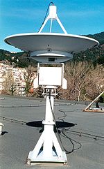 Computer-controlled motorized parabolic dish antenna for tracking
LEO
weather satellites.
Computer-controlled motorized parabolic dish antenna for tracking
LEO
weather satellites.
Polar orbiting weather satellites circle the Earth at a typical altitude of 850 km (530 miles) in a north to south (or vice versa) path, passing over the poles in their continuous flight. Polar orbiting weather satellites are in
sun-synchronous orbits
, which means they are able to observe any place on Earth and will view every location twice each day with the same general lighting conditions due to the near-constant local
solar time
. Polar orbiting weather satellites offer a much better resolution than their geostationary counterparts due their closeness to the Earth.
The United States has the
NOAA
series of polar orbiting meteorological satellites, presently NOAA-15, NOAA-18 and NOAA-19 (
POES
) and NOAA-20 (
JPSS
). Europe has the
Metop
-A,
Metop
-B and
Metop
-C satellites operated by
EUMETSAT
. Russia has the
Meteor
and RESURS series of satellites. China has
FY
-3A, 3B and 3C. India has polar orbiting satellites as well.
DMSP
[
edit
]
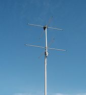 Turnstile antenna
for reception of 137 MHz
LEO
weather satellite transmissions
Turnstile antenna
for reception of 137 MHz
LEO
weather satellite transmissions
The
United States Department of Defense
's Meteorological Satellite (
DMSP
) can "see" the best of all weather vehicles with its ability to detect objects almost as 'small' as a huge
oil tanker
. In addition, of all the weather satellites in orbit, only DMSP can "see" at night in the visual. Some of the most spectacular photos have been recorded by the night visual sensor; city lights,
volcanoes
, fires, lightning,
meteors
, oil field burn-offs, as well as the
Aurora Borealis
and
Aurora Australis
have been captured by this 720 kilometres (450 mi) high space vehicle's low moonlight sensor.
At the same time, energy use and city growth can be monitored since both major and even minor cities, as well as highway lights, are conspicuous. This informs
astronomers
of
light pollution
. The
New York City Blackout of 1977
was captured by one of the night orbiter DMSP space vehicles.
In addition to monitoring city lights, these photos are a life saving asset in the detection and monitoring of fires. Not only do the satellites see the fires visually day and night, but the thermal and
infrared
scanners on board these weather satellites detect potential fire sources below the surface of the Earth where smoldering occurs. Once the fire is detected, the same weather satellites provide vital information about wind that could fan or spread the fires. These same cloud photos from space tell the
firefighter
when it will rain.
Some of the most dramatic photos showed the 600
Kuwaiti oil fires
that the fleeing
Army of Iraq
started on February 23, 1991. The night photos showed huge flashes, far outstripping the glow of large populated areas. The fires consumed huge quantities of oil; the last was doused on November 6, 1991.
Uses
[
edit
]
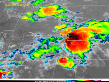 Infrared image of storms over the central United States from the
GOES-17
satellite
Infrared image of storms over the central United States from the
GOES-17
satellite
Snowfield monitoring, especially in the
Sierra Nevada
, can be helpful to the hydrologist keeping track of available
snowpack
for runoff vital to the
watersheds
of the western United States. This information is gleaned from existing satellites of all agencies of the U.S. government (in addition to local, on-the-ground measurements). Ice floes, packs, and bergs can also be located and tracked from weather spacecraft.
Even pollution whether it is nature-made or human-made can be pinpointed. The visual and infrared photos show effects of pollution from their respective areas over the entire earth. Aircraft and
rocket
pollution, as well as
condensation trails
, can also be spotted. The ocean current and low level wind information gleaned from the space photos can help predict oceanic oil spill coverage and movement. Almost every summer, sand and dust from the
Sahara Desert
in Africa drifts across the equatorial regions of the Atlantic Ocean. GOES-EAST photos enable meteorologists to observe, track and forecast this sand cloud. In addition to reducing visibilities and causing respiratory problems, sand clouds suppress
hurricane
formation by modifying the
solar radiation
balance of the tropics. Other
dust storms
in Asia and
mainland China
are common and easy to spot and monitor, with recent examples of dust moving across the Pacific Ocean and reaching North America.
In remote areas of the world with few local observers, fires could rage out of control for days or even weeks and consume huge areas before authorities are alerted. Weather satellites can be a valuable asset in such situations. Nighttime photos also show the burn-off in gas and oil fields. Atmospheric temperature and moisture profiles have been taken by weather satellites since 1969.
[17]
Non-imaging sensors
[
edit
]
Not all weather satellites are direct
imagers
. Some satellites are
sounders
that take measurements of a single
pixel
at a time. They have no
horizontal
spatial resolution
but often are capable or resolving vertical
atmospheric layers
. Soundings along the satellite
ground track
can still be
gridded
later to form
maps
.
International regulation
[
edit
]
 Weather observation satellite-system, NOAA-M spacecrft
According to the
International Telecommunication Union
(ITU), a
meteorological-satellite service
(also:
meteorological-satellite radiocommunication service
) is ? according to
Article 1.52
of the
ITU Radio Regulations
(RR)
[18]
? defined as
≪ An
earth exploration-satellite service
for
meteorological
purposes.≫
Classification
[
edit
]
This
radiocommunication service
is classified in accordance with
ITU Radio Regulations
(article 1) as follows:
Fixed service
(article 1.20)
Frequency allocation
[
edit
]
The allocation of radio frequencies is provided according to
Article 5
of the ITU Radio Regulations (edition 2012).
[19]
In order to improve harmonisation in spectrum utilisation, the majority of service-allocations stipulated in this document were incorporated in national Tables of Frequency Allocations and Utilisations which is with-in the responsibility of the appropriate national administration. The allocation might be primary, secondary, exclusive, and shared.
- primary allocation: is indicated by writing in capital letters (see example below)
- secondary allocation: is indicated by small letters
- exclusive or shared utilization: is within the responsibility of administrations
- Example of
frequency allocation
| Allocation to services
|
| Region 1
|
Region 2
|
Region 3
|
401-402 MHz METEOROLOGICAL AIDS
- SPACE OPERATION (space-to-Earth)
EARTH EXPLORATION-SATELLITE (Earth-to-space)
METEOROLOGICAL-SATELLITE (Earth-to-space)
Fixed
Mobile except aeronautical mobile
|
8 817.50-8 821.50 MHz
METEOROLOGICAL-SATELLITE (Earth-to-space)
- and other services
|
See also
[
edit
]
References
[
edit
]
- ^
NESDIS
.
Satellites.[link not working]
Retrieved on July 4, 2008.
Archived
July 4, 2008, at the
Wayback Machine
- ^
NOAA
.
NOAA Satellites, Scientists Monitor Mt. St. Helens for Possible Eruption.
Archived
September 10, 2012, at
archive.today
Retrieved on July 4, 2008.
- ^
a
b
Janice Hill (1991).
Weather From Above: America's Meteorological Satellites
. Smithsonian Institution. pp. 4?7.
ISBN
978-0-87474-394-4
.
- ^
"VANGUARD - A HISTORY, CHAPTER 12, SUCCESS - AND AFTER"
. NASA. Archived from
the original
on May 9, 2008.
- ^
"U.S. Launches Camera Weather Satellite".
The Fresno Bee
.
AP
and
UPI
. April 1, 1960. pp. 1a, 4a.
- ^
National Environmental Satellite Center (January 1970). "SIRS and the Improved Marine Weather Forecast".
Mariners Weather Log
.
14
(1). Environmental Science Services Administration: 12?15.
- ^
"DSCOVR: Deep Space Climate Observatory | NOAA National Environmental Satellite, Data, and Information Service (NESDIS)"
.
www.nesdis.noaa.gov
. Retrieved
August 5,
2021
.
- ^
EUMETSAT ? MSG Spectrum
Archived
November 28, 2007, at the
Wayback Machine
(PDF)
- ^
"EUMETSAT ? MFG Payload"
. Archived from
the original
on November 25, 2008
. Retrieved
November 21,
2007
.
- ^
A. F. Hasler; K. Palaniappan; C. Kambhammetu; P. Black; E. Uhlhorn; D. Chesters.
High-Resolution Wind Fields within the Inner Core and Eye of a Mature Tropical Cyclone from GOES 1-min Images
(Report)
. Retrieved
July 4,
2008
.
- ^
Chris Landsea
.
Subject: H1) What is the Dvorak technique and how is it used?
Retrieved on January 3, 2009.
- ^
Service, US Department of Commerce, NOAA, National Weather.
"National Weather Service"
.
{{
cite web
}}
: CS1 maint: multiple names: authors list (
link
)
- ^
Tollefson, Jeff (March 2, 2018).
"Latest US weather satellite highlights forecasting challenges"
.
Nature
.
555
(7695): 154.
Bibcode
:
2018Natur.555..154T
.
doi
:
10.1038/d41586-018-02630-w
.
- ^
"GOES-17 Transition to Operations │ GOES-R Series"
.
www.goes-r.gov
. Retrieved
May 26,
2019
.
- ^
Balmaseda M, A Barros, S Hagos, B Kirtman, H-Y Ma, Y Ming, A Pendergrass, V Tallapragada, E Thompson. 2020. "NOAA-DOE Precipitation Processes and Predictability Workshop." U.S. Department of Energy and U.S. Department of Commerce NOAA; DOE/SC-0203; NOAA Technical Report OAR CPO-9
- ^
"?星?行"
[Satellite Operation].
National Satellite Meteorological Center of CMA
(in Chinese). Archived from
the original
on August 28, 2015.
- ^
Ann K. Cook (July 1969).
"The Breakthrough Team"
(PDF)
.
ESSA World
. Environmental Satellite Services Administration: 28?31. Archived from
the original
(PDF)
on February 25, 2014
. Retrieved
April 21,
2012
.
- ^
ITU Radio Regulations, Section IV. Radio Stations and Systems ? Article 1.52, definition:
meteorological-satellite service / meteorological-satellite radiocommunication service
- ^
ITU Radio Regulations, CHAPTER II ? Frequencies, ARTICLE 5 Frequency allocations, Section IV ? Table of Frequency Allocations
External links
[
edit
]
- Theory
- Data
- Near realtime composite of satellite image of the Earth
by
Intellicast
- International weather satellite viewer
Online geostationary weather satellite viewer with 2 months of archived data.
- Earth at night
by NASA
- EUMETSAT ? the European Organisation for the Exploitation of Meteorological Satellites
- NASA Langley Cloud and Radiation Research
Near real-time and archived satellite imagery and cloud products.
- ISCCP Global ISCCP B1 Browse System (GIBBS)
http://www.ncdc.noaa.gov/gibbs/
;Government policy
- Geostationary Weather Satellites: Progress Made, but Weaknesses in Scheduling, Contingency Planning, and Communicating with Users Need To Be Addressed: Report to the Committee on Science, Space, and Technology, House of Representatives
Government Accountability Office
- Polar Weather Satellites: NOAA Identified Ways to Mitigate Data Gaps, but Contingency Plans and Schedules Require Further Attention: Report to the Committee on Science, Space, and Technology, House of Representatives
Government Accountability Office