Islands of New Caledonia
Hunter Island
and
Matthew Island
are two small and uninhabited
volcanic islands
in the South Pacific, located 300 kilometres (190 mi) east of
New Caledonia
and south-east of
Vanuatu
archipelago. Hunter Island and Matthew Island, 70 km (43 mi) apart, are claimed by Vanuatu as part of
Tafea Province
, and considered by the people of
Aneityum
part of their custom ownership, and as of 2007
[update]
were claimed by
France
as part of
New Caledonia
.
[1]
Small, arid, without fresh water and not easily accessible, the islands had no interest for Britain or France during their colonisation of the Pacific in the course of the 18th and 19th centuries. France officially annexed both islands in 1929. In 1965, the
United Kingdom
also claimed the two islands, as part of the
New Hebrides
. France conducted a symbolic occupation in 1975. In 1980, on its independence, Vanuatu claimed sovereignty, but made no occupation of the islands. In 1979,
Meteo-France
set up an automatic weather station on one of the islands, and the
French Navy
regularly visits both of them.
Hunter Island
[
edit
]
Hunter Island (
French
:
ile Hunter
) is also known as "Fern or Fearn Island", or "Leka" in the local language of Futuna island in southern Vanuatu. The first recorded European sighting of the island was by
Captain Thomas Fearn
from his trading ship
Hunter
in 1798.
[2]
It lies 70 km (43 mi) east of Matthew Island at
22°24′S
172°5′E
/
22.400°S 172.083°E
/
-22.400; 172.083
. About 0.6 square kilometres (0.23 sq mi) in area, the island has a domed shape, and is 242 metres (794 ft) high. It is composed of
andesite
? dacitic lavas and numerous explosion craters dot the volcano. A cone makes up the south part of the island, with its central crater filled by a lava dome. A 100 m (330 ft)-deep crater is located on the north-west side of the island. Fumarolic and
solfataric
activity continues in the north of the island, as well as on the northeast and southeast coasts.
[3]
Two small eruptions took place in the mid-1800s. In 1835, a lava flow erupted and on 15 March 1841, an explosive eruption took place. In 1895, lava was seen flowing from two craters on the east side of the island. A small (VEI 0) fissure eruption took place in 1903, on the northern side of the island, and produced lava.
Hunter Island is symbolically claimed by a
micronation
, the Federal Republic of Lostisland.
[4]
[
clarification needed
]
Important Bird Area
[
edit
]
The island has been recognised as an
Important Bird Area
(IBA) by
BirdLife International
because it supports a breeding population of
red-tailed tropicbirds
, with some 100?200 pairs estimated in 2007.
[5]
Matthew Island
[
edit
]
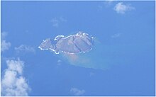 Matthew Island aerial view
Matthew Island (
French
:
ile Matthew
) is also known as Umaenupne island in the indigenous language of Aneityum island in southern Vanuatu, the closest inhabited island. It is 0.7 square kilometres (0.27 sq mi) in area, with a 177-metre (581 ft) high
stratovolcano
located at
22°21′S
171°21′E
/
22.350°S 171.350°E
/
-22.350; 171.350
. The volcanic island is composed of two andesitic-to-dactic volcanic cones, East Matthew and West Matthew, separated by a rocky 200-metre-wide isthmus. The island was discovered by Captain Thomas Gilbert, of
Charlotte
, on 27 May 1788, who named it after the owner of his ship. At the time of the discovery, only East Matthew existed and it was described as having only one peak prior to the Second World War.
East Matthew is the older part of the island, formed from
basalt
with a half-destroyed, 142-m-high composite volcanic cone that is thought to be composed of three
lava flows
. There is still some volcanic activity on the island with sulphuric
fumaroles
rising from craters in the south-east. West Matthew formed in the late 1940s and may have had eruptions as recent as 1976. It is a roughly circular, 177 m (581 ft)-high cone with a serrated peak and is composed almost entirely of lava flows and slag. It contains a crater that is breached to the northwest. A lava flow from West Matthew makes up the northwest coast of the island.
[3]
Eruptions
[
edit
]
All known historical eruptions have come from West Matthew. After a highly seismically active period in the 1940s, construction of West Matthew began as submarine eruptions built up a new island. The new cone then emitted lava flows. The eruption was a
VEI
2. Another VEI 2 eruption from West Matthew took place in October 1954, while a very small (VEI 0) fissure eruption occurred in approximately 1956. This marks the latest confirmed activity on Matthew Island, although tremors took place near the island in 2008, 2009 and 2011. Uncertainty surrounds a report of an eruption in 1828, as well as reports of eruptions in 1966 and 1976.
Important Bird Area
[
edit
]
The island has been recognised as an
Important Bird Area
(IBA) by
BirdLife International
because it supports breeding populations of
brown boobies
and
blue noddies
.
[6]
Seismicity
[
edit
]
The islands are prone to earthquakes, as they are situated near the southern arc of the South New Hebrides Trench, where the minor
New Hebrides Plate
is
subducted
by the
Australian Plate
. In February 2021, a 7.7
quake was centered in the vicinity of Matthew and Hunter.
[7]
Tectonics
[
edit
]
Both Matthew Island and Hunter Island are within the
Hunter Ridge
part of the New Hebrides Plate and this ridge was initially formed from about 7 to 3 million years ago, when the opening of the
North Fiji Basin
in a north?south direction, allowed northward subduction of the
South Fiji Basin
part of the then
Indo-Australian Plate
under the North Fiji Basin.
[8]
: 915
From about 3 million years ago the current triple junction between the New Hebrides Plate, Australian Plate and the
Conway Reef Plate
became established and the southernmost propagating tip of the Central Spreading Ridge backarc-spreading centre in the North Fiji Basin over the last 2 million years has rifted westward splitting the Hunter Ridge into two halves.
[9]
: 3
New young subduction of the South Fiji Basin has created what has been called the Matthew and Hunter subduction zone.
[9]
: 3
The various processes have resulted in unusually complex volcanic composition of the island's recent eruptives, as well as the continued seismicity assigned to the area as the south western part of the
Hunter Fracture Zone
.
[8]
: 913
[9]
: 3, 12
See also
[
edit
]
References
[
edit
]
- ^
"Small Islands Voice"
.
UNESCO
. Archived from
the original
on 14 February 2017
. Retrieved
28 December
2019
.
- ^
Sharp, Andrew (1962),
The discovery of the Pacific Islands
, Oxford University Press, p.181
- ^
a
b
Maillet, P.; Monzier, M.; Lefevre, C. (1986). "Petrology of Matthew and Hunter volcanoes, south New Hebrides island arc (southwest Pacific)".
J. Volcanol. Geotherm. Res
.
30
(1): 1?27.
Bibcode
:
1986JVGR...30....1M
.
doi
:
10.1016/0377-0273(86)90065-X
.
- ^
Cortbus, Colin.
"Internet Eccentrics on Expedition To Hunter Island"
.
Vanuatu Daily Post
. Retrieved
13 December
2017
.
- ^
"Hunter Island"
.
BirdLife Data Zone
. BirdLife International. 2021
. Retrieved
16 February
2021
.
- ^
"Matthew Island"
.
BirdLife Data Zone
. BirdLife International. 2021
. Retrieved
16 February
2021
.
- ^
"M 7.7 - southeast of Loyalty Islands"
.
United States Geological Survey
. 10 February 2021.
- ^
a
b
Durance, PM; Jadamec, MA; Falloon, TJ; Nicholls, IA (1 August 2012).
"Magmagenesis within the Hunter Ridge Rift Zone resolved from olivine-hosted melt inclusions and geochemical modelling with insights from geodynamic models"
.
Australian Journal of Earth Sciences
.
59
(6): 913?31.
Bibcode
:
2012AuJES..59..913D
.
doi
:
10.1080/08120099.2012.682096
.
S2CID
67848457
.
- ^
a
b
c
McCarthy, A; Falloon, TJ; Danyushevsky, LV; Sauermilch, I; Patriat, M; Jean, MM; Maas, R; Woodhead, JD; Yogodzinski, GM (15 July 2022).
"Implications of high-Mg# adakitic magmatism at Hunter Ridge for arc magmatism of the Fiji-Vanuatu region"
.
Earth and Planetary Science Letters
.
590
(117592): 1?14.
Bibcode
:
2022E&PSL.59017592M
.
doi
:
10.1016/j.epsl.2022.117592
.
hdl
:
20.500.11850/553552
.
Bibliography
[
edit
]
- Dunmore, John:
Who's who in Pacific navigation
, Honolulu: Univ. of Hawaii Pr., 1991
ISBN
0-8248-1350-2
- Sharp, Andrew:
The discovery of the Pacific Islands
, Oxford 1960
- "Matthew Island"
.
Global Volcanism Program
.
Smithsonian Institution
. Retrieved
28 June
2021
.
- "Matthew Island Volcano"
.
volcanolive.com
. Retrieved
28 December
2019
.
- Song, Lily & Mosses, Morsen: "Revisiting Ocean Boundary Disputes in the South Pacific in Light of the South China Sea Arbitration: A Legal Perspective", The International Journal of Marine and Coastal Law 33 (2018): 768 - 798
- Lili Song, Morsen Mosses & Geraldine Giraudeau (2023): The Ambiguous History of Matthew and Hunter Islands: Tracing the Roots of Vanuatu and French Claims, The Journal of Pacific History, DOI: 10.1080/00223344.2022.2146577
External links
[
edit
]