River in New South Wales, Australia
| Manning River
|
|---|
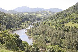 Manning River, upstream of Mount George
|
| Etymology
| In honour of
Sir William Manning
[1]
|
|---|
| Native name
| Boolumbahtee
(
Birrpayi
)
[2]
|
|---|
|
| Country
| Australia
|
|---|
| State
| New South Wales
|
|---|
| Region
| New England Tablelands
,
NSW North Coast
(
IBRA
),
Northern Tablelands
,
Mid North Coast
|
|---|
| Local government area
| Mid-Coast Council
|
|---|
| Towns
| Wingham
,
Taree
|
|---|
|
|
| Source
| Mount Barrington
,
Great Dividing Range
|
|---|
| • location
| Barrington Tops National Park
, near
Ellerston
|
|---|
| • coordinates
| 31°54′S
151°28′E
/
31.900°S 151.467°E
/
-31.900; 151.467
|
|---|
| • elevation
| 1,500 m (4,900 ft)
|
|---|
|
|
| Mouth
| Tasman Sea
of the
South Pacific Ocean
|
|---|
• location
| Old Bar
and
Harrington Point
|
|---|
• coordinates
| 31°53′S
152°42′E
/
31.883°S 152.700°E
/
-31.883; 152.700
|
|---|
• elevation
| 0 m (0 ft)
|
|---|
| Length
| 261 km (162 mi)
|
|---|
| Basin size
| 8,125 km
2
(3,137 sq mi)
|
|---|
|
| Discharge
|
|
|---|
| • location
| Near mouth
|
|---|
| • average
| 63 m
3
/s (2,000 GL/a)
[3]
|
|---|
|
|
|
| Tributaries
|
|
|---|
| • left
| Backwater Creek,
Pigna Barney River
,
Barnard River
,
Nowendoc River
,
Connollys Creek
,
Bobin Creek
,
Dingo Creek
,
Cedar Party Creek
,
Dawson River
,
Lansdowne River
|
|---|
| • right
| Gloucester River
, Bakers Creek (New South Wales), Burrell Creek (New South Wales), Scotts Creek (New South Wales)
|
|---|
| National parks
| Barrington Tops
,
Woko
,
|
|---|
| [4]
|
Manning River
(
Biripi
:
Boolumbahtee
[2]
), an open and
trained
mature
wave dominated
barrier estuary
,
[5]
is located in the
Northern Tablelands
and
Mid North Coast
districts of
New South Wales
, Australia. It is the only double delta river in the southern hemisphere in which there are two permanent entrances to the river, one at
Old Bar
and another at
Harrington
, and is famously one of only two rivers in the world to have permanent multiple entrances with the other being the
Nile river
in Egypt.
[6]
Course and features
[
edit
]
 Cargo wharf at
Wingham
Cargo wharf at
Wingham
Manning River rises below
Mount Barrington
, on the northeastern slopes of the
Great Dividing Range
within
Barrington Tops National Park
, east southeast of
Ellerston
, and flows generally southeast, joined by eleven
tributaries
including the
Pigna Barney
,
Barnard
,
Nowendoc
,
Gloucester
,
Dawson
, and
Lansdowne
rivers, descending 1,500 metres (4,900 ft) over its 261-kilometre (162 mi)
course
from the high upper reaches, through the Manning Valley, and out to sea.
[4]
The river flows past the towns of
Wingham
and
Taree
. At Taree, the river splits and becomes a
double delta
. The southern arm reaches its
mouth
at the
Tasman Sea
of the
South Pacific Ocean
, near
Old Bar
. The northern arm is joined by the Dawson River and further downstream the Lansdowne River, reaching its mouth at the Tasman Sea, near
Harrington Point
; creating two separate entrances to the river: Harrington Inlet (north) and Farquhar Inlet (south). Within the delta there are several channels dividing coastal land into large islands, such as
Mitchells
and Oxley islands. Between
Croki
(in the north) and Cabbage Tree Island east of
Bohnock
(in the south), Scotts Creek links both the northern and southern passages of the river.
The Manning River is one of Australia's few large river systems that have not been
dammed
for water supply purposes anywhere along its catchment. The local water supply is fed by Bootawa Dam, which is an offsite dam, however, water is pumped from the river to the dam whenever river turbidity and flow levels can allow. A small
weir
is located in the upper reaches of the Barnard River, part of the
inter-basin water transfer
of the
Barnard River Scheme
, enabling water to be pumped into the
Hunter River
to meet the cooling needs of
Bayswater
and
Liddell
electric
power stations
.
[7]
[8]
[9]
The scheme is shut down until needed but as of 2006 this scheme was partly decommissioned due to its rare use.
[
citation needed
]
The Manning River is one of only a few Australian mainland rivers to receive annual winter melting snow deposits.
[
citation needed
]
The Manning River is variously traversed by the
Pacific Highway
between Taree and
Coopernook
, and the
North Coast railway line
at Taree.
History
[
edit
]
The traditional custodians of the land surrounding the Manning River and its associated valley are the
Australian Aboriginal
Biripi
,
[10]
who named the river as
Boolumbahtee
, meaning a place where the
brolgas
played.
[2]
In 1818,
John Oxley
crossed and named Harrington and Farquhar inlets during a trip from the
Hastings River
, near
Port Macquarie
, to
Port Stephens
. The Manning River itself was first surveyed by
Henry Dangar
in 1825 and again in 1826 on behalf of the
Australian Agricultural Company
. Later in 1826, the river was named the Manning River by
Robert Dawson
for the Deputy Governor of the Australian Agricultural Company,
William Manning
.
[11]
In the same year it was declared that the Manning was the northern limit of the
Nineteen Counties
, defining the areas of New South Wales where settlers were free to occupy.
Until 1913, ships servicing the coast brought goods and supplies up the river. Wingham was established at the furthest point supply boats could reach up the river and became the region's major port. The old cargo wharf at Wingham Brush has since been refurbished. The town of
Tinonee
was also settled on the river near Taree.
In 2008 a pod of bottle-nosed dolphins became stranded up stream from Wingham between Jackson and Abbotts Falls (visible from Brushy Cutting Lookout). Authorities observed, but did not intervene. Despite this area having adequate food, and a high level of water, all dolphins soon died stranded in this section of fresh and/or brackish water. This is assumed by specialists now to relate to low salinity water leading to Fresh Water Skin Disease. Necroscopys and water testing were not carried out.
In March 2021, a record breaking low pressure trough brought intense rainfall to the Manning Valley catchment area,
[12]
inundating properties at
Taree
and
Wingham
. It peaked at 5.7 m (19 ft) in Taree, falling just short of the record 6 m (20 ft) flood of 1929.
[13]
In September 2023 a pod of five bottle-nosed dolphins became entrapped in a fresh water section of the Manning River, again between Jackson and Abbotts Falls. First observations reported one deceased dolphin, and the four surviving dolphins abnormal behaviour thrashing in deep sections of river and remaining circling within a small section of the river. Relevant authorities were notified. A period of observation of the dolphins was enacted. Water testing some days later revealed the water was fresh, and not brackish as had been presumed. Fresh Water Skin Disease quickly developed in all dolphins as a result of prolonged fresh water exposure.
[14]
Visual growths and deep lesions became evident, even from the shore, and the last surviving dolphins colours began to change. Rescue was formally enacted after three of the dolphins were found deceased.
[15]
The fourth dolphin perished the day following, before rescue could be enacted. A skilled multidisciplinary team, carried out a successful and humane capture of the only surviving dolphin on 17th September 2023.
[16]
Once captured, the final dolphin, who came to be known as Forest, was initially given medical clearance to travel to Sea World Foundation, QLD to be rehabilitated. On full recovery Forest would have been released locally in the Mid-Coast. Forest was sedated with specialist marine mammal vets and a team of volunteers alongside her. She was travelling in a specialty equipped veterinary vehicle and was under sedation with the specialist team all around her when she died. Necroscopy showed prolonged exposure to fresh water conditions led to array of major health concerns, ultimately organ failure (Fresh Water Skin Disease).
The pod of five dolphins perished within 5.5- 13.5 days of becoming entrapped in fresh water conditions. This event is being used to better understand Fresh Water Skin disease internationally, and to support better outcomes if this happens again in this stretch of the Manning River.
Ecology
[
edit
]
The Manning River is a large producer of Australian oysters and is home to many fish, the most common being the
Dusky Flathead
(
Platycephalus fuscus
), a common Australian estuary fish. It is also a habitat for the endangered Manning River helmeted turtle, which is
endemic
to the upper and middle catchments.
[17]
[18]
The Manning River is frequented by dolphins and sharks, with some venturing as far up the river to Wingham.
Whales also frequent the river, mainly at the larger Harrington Inlet, although some do enter the Farquar Inlet and generally do not venture far up river. However, on 16 September 1994 a rare tropical
Bryde's whale
measuring 9-metre (30 ft) long, nicknamed "Free Willy" by locals, ventured much further up river to Taree. After becoming a tourist attraction, and repeatedly evading attempts by conservationists to free him "Free Willy" was finally rescued by Seaworld Staff in conjunction with NSW National Parks And Wildlife and ORCA (Organisation for the Rescue and Research of Cetaceans in Australia). "Willy" became stranded on a sandbar, and with the assistance of a specially designed inflatable Cetacean Rescue Device, floated and towed back out to sea and was last seen heading for deeper water to the east.
[19]
[20]
Events and industry
[
edit
]
Taree is home to the annual Manning River Summer Festival, which features
rowing
, and
sailing
. The Taree Powerboat Club Spectacular is held in the Manning River during the
Easter
long weekend.
The
Manning Point Fishing Classic
, held annually at
Manning Point
is the Australian leg of the
Poissons et boisson extremes
extreme fishing tour. The tour pits an invitation only collection of notorious fishers, known for their extreme dedication to the twin arts of fishing and drinking.
Commercial fishing and oyster farming are both practiced in the Manning. The peak season for oyster production is September to March; and the annual production during 2013 was 146,000
dozen
.
[21]
The link between Taree and the
oyster
industry is shown by the presence in Taree of the "
Big Oyster
", a building constructed in the shape of an open oyster shell.
The Manning River area is popular for domestic tourism.
See also
[
edit
]
References
[
edit
]
- ^
Reed A. W.
(1984).
Place Names of Australia
(3rd reprint ed.).
Reed Books
. p. 146.
ISBN
0-589-50128-3
.
- ^
a
b
c
Collier, Gloria; O'Hara, Joan (February 1998).
"Oxley Island"
.
The Journal
(3). Manning Valley Historical Society.
Archived
from the original on 4 March 2016
. Retrieved
16 March
2013
.
- ^
"East Coastal Watersheds"
.
- ^
a
b
"Map of Manning River, NSW"
. Bonzle Digital Atlas of Australia
. Retrieved
16 March
2013
.
- ^
Roy, P. S.; Williams, R. J.; Jones, A. R.; Yassini, I.; et al. (2001). "Structure and Function of South-east Australian Estuaries".
Estuarine, Coastal and Shelf Science
.
53
(3): 351?384.
doi
:
10.1006/ecss.2001.0796
.
- ^
Driscoll, Julia (12 December 2019).
"The river runs dry: Manning River at zero flow"
.
The Canberra Times
. Retrieved
1 October
2021
.
- ^
"Macquarie Generation Hunter River Pump Station Augmentation Environmental Assessment"
(PDF)
.
Connell Wagner Pty Ltd
.
Macquarie Generation
. 16 January 2007. p. 29
. Retrieved
16 March
2013
.
- ^
"Macquarie Generation"
.
Office of Water
.
Department of Primary Industries
. 12 December 2011
. Retrieved
16 March
2013
.
- ^
"Hunter River NSW"
.
Hunter River Explorer
. Archived from
the original
on 9 April 2013
. Retrieved
16 March
2013
.
- ^
Klaver, J; Kefferman, K J.
"Aboriginal Culture and history in the Manning Valley"
(PDF)
.
Greater Taree Aboriginal Heritage Study
. Manning Valley Tourism. p. 1
. Retrieved
16 March
2013
.
[
permanent dead link
]
- ^
The Present State of Australia by Robert Dawson, page 372.
- ^
"Martin Bridge at Taree closed to all traffic, including emergency services"
.
Manning River Times
. Australian Community Media. 21 March 2021
. Retrieved
22 March
2021
.
- ^
http://www.bom.gov.au/climate/current/statements/scs74.pdf
[
bare URL PDF
]
- ^
Necroscopy findings
- ^
GIPA FOI obtained
- ^
evident in provided photographs
- ^
"MANNING RIVER TURTLE"
.
Aussie Ark
. 20 July 2021
. Retrieved
1 October
2021
.
- ^
"Manning River Helmeted Turtle, Purvis' Turtle - profile | NSW Environment, Energy and Science"
.
environment.nsw.gov.au
. Retrieved
1 October
2021
.
- ^
"Australians trying to free whale Willy"
.
Eugene Register-Guard
. Associated Press. 17 November 2004
. Retrieved
19 May
2010
.
- ^
Bryde's whale breaches off Tacking Point coastline
- ^
Parker, Sarah (5 June 2013).
"Plan for future health of Manning oyster industry"
.
Manning River Times
. Retrieved
13 October
2013
.
External links
[
edit
]
|
|---|
Towns, suburbs
and localities
| |
|---|
Rivers and
other waterways
| |
|---|
| National parks
| |
|---|
Other places and
points of interest
| |
|---|
|
|---|
|
Education
|
|---|
| Primary
| |
|---|
| Secondary
| |
|---|
| Tertiary
| |
|---|
|
|
Entertainment, sport & culture
|
|---|
|
|
|
Historical
|
|---|
| Air transport
| |
|---|
| Defence
| |
|---|
| Education
| |
|---|
| General
| |
|---|
| Industry
| |
|---|
| Maritime
| |
|---|
| Natural disasters
| |
|---|
| Rail
| | General
| |
|---|
| Railway lines
| |
|---|
| Railway stations
| |
|---|
| Trams
| |
|---|
|
|---|
| Wine making
| |
|---|
| World War II
| |
|---|
|
|
Infrastructure
|
|---|
| Transport
| | Road
| |
|---|
| Road bridges
| |
|---|
| Railway lines
| |
|---|
| Railway stations
| |
|---|
| Bus
| |
|---|
| Air
| |
|---|
| Ferry
| |
|---|
| Light rail
| |
|---|
|
|---|
| Utilities
| | Electricity generation
| |
|---|
| Water supply
| |
|---|
|
|---|
|
|
|
Other
|
|---|
| Defence
| |
|---|
| General
| |
|---|
| Health & medical research
| |
|---|
|
|