From Wikipedia, the free encyclopedia
River in Brazil, Bolivia
| Mamore River
|
|---|
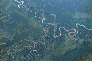 Confluence of the Ivirgarzama River and the
Ichilo River
, and of the
Chimore River
and the Ichilo River to the Mamore River (north is to the upper right corner of this
ISS
image)
|
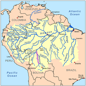 Map of the Amazon Basin with the Mamore River highlighted
|
|
| Country
| Brazil
,
Bolivia
|
|---|
|
|
| Source
| Sierra de Cochabamba
|
|---|
| • location
| Pojo
, Bolivia
|
|---|
| • coordinates
| 17°37′59″S
64°56′02″W
/
17.633°S 64.934°W
/
-17.633; -64.934
|
|---|
| • elevation
| 3,372 m (11,063 ft)
|
|---|
|
|
| Mouth
| Madeira River
|
|---|
• location
| near Vila Murtinho, Brazil/Bolivia border
|
|---|
• coordinates
| 10°22′59″S
65°23′35″W
/
10.383°S 65.393°W
/
-10.383; -65.393
|
|---|
• elevation
| 110 m (360 ft)
|
|---|
| Length
| 1,930 km (1,200 mi)
[1]
|
|---|
| Basin size
| 637,401.1 km
2
(246,101.9 sq mi)
[2]
|
|---|
|
| Discharge
|
|
|---|
| • location
| Near mouth
|
|---|
| • average
| (Period: 1985?2013)8,150 m
3
/s (288,000 cu ft/s)
[3]
(Period: 1971?2000)8,857.3 m
3
/s (312,790 cu ft/s)
[2]
|
|---|
|
|
|
| Discharge
|
|
|---|
| • location
| Guayaramerin
(Basin size: 611,800 km
2
(236,200 sq mi)
|
|---|
| • average
| (Period: 1985?2013)7,650 m
3
/s (270,000 cu ft/s)
[3]
(Period: 1971?2000)8,414.5 m
3
/s (297,160 cu ft/s)
[2]
|
|---|
| • minimum
| (Period: 1985?2013)1,660 m
3
/s (59,000 cu ft/s)
[3]
|
|---|
| • maximum
| (Period: 1985?2013)15,200 m
3
/s (540,000 cu ft/s)
[3]
|
|---|
|
|
|
| Discharge
|
|
|---|
| • location
| Puerto Siles
(Basin size: 229,300 km
2
(88,500 sq mi)
|
|---|
| • average
| (Period: 1985?2013)4,600 m
3
/s (160,000 cu ft/s)
[3]
|
|---|
| • minimum
| (Period: 1985?2013)1,180 m
3
/s (42,000 cu ft/s)
[3]
|
|---|
| • maximum
| (Period: 1985?2013)8,850 m
3
/s (313,000 cu ft/s)
[3]
|
|---|
|
|
|
| Discharge
|
|
|---|
| • location
| Camiaco (Basin size: 128,800 km
2
(49,700 sq mi)
|
|---|
| • average
| (Period: 1985?2013)2,180 m
3
/s (77,000 cu ft/s)
[3]
|
|---|
| • minimum
| (Period: 1985?2013)750 m
3
/s (26,000 cu ft/s)
[3]
|
|---|
| • maximum
| (Period: 1985?2013)3,900 m
3
/s (140,000 cu ft/s)
[3]
|
|---|
|
|
|
| Progression
| Madeira
→
Amazon
→
Atlantic Ocean
|
|---|
| River system
| Amazon
|
|---|
| Tributaries
|
|
|---|
| • left
| Chapare
,
Isiboro
,
Apere
,
Yacuma
,
San Miguel
,
Yata
|
|---|
| • right
| Rio Grande
,
Ibare
,
Guapore
, Pacaas Novo
|
|---|
The
Mamore
is a large river in
Brazil
and
Bolivia
which unites with the
Madre de Dios River
to form the
Madeira
, one of the largest tributaries of the
Amazon
. It rises on the northern slope of the Sierra de Cochabamba, east of the city of
Cochabamba
, and is known as the
Chimore
down to its junction with the
Chapare
. Its larger tributaries are the
Chapare
,
Secure
,
Apere
, and
Yacuma
from the west, and the
Ichilo
,
Guapay
, Ivari, Manique and
Guapore
from the east. Taking into account its length only, the Guapay should be considered the upper part of the Mamore; but it is shallow and obstructed, and carries a much smaller volume of water. The Guapore also rivals the Mamore in length and volume, having its source in the
Parecis plateau
,
Mato Grosso
, Brazil, a few miles from streams flowing north-ward to the
Tapajos
and Amazon, and southward to the
Paraguay
and
Parana
rivers. The Mamore is interrupted by rapids a few miles above its junction with the Beni, but a railway 300 km long has been undertaken from below the rapids of the Madeira. Above the rapids the river is navigable to
Chimore
, at the foot of the sierra, and most of its tributaries are navigable for long distances. In 1874, Franz Keller gave the outflow of the Mamore at mean water level, and not including the Guapore, as 41,459 cm
3
/sec (2,530 cub. in. per second), and the area of its
drainage basin
, also not including the Guapore, as 24,299 km
2
(9,382 square miles).
[4]
An extensive pre-Columbian civilization existed in the basin of the Mamore in the swampy area known as the
Llanos de Moxos
, in northeastern Bolivia.
See also
[
edit
]
References
[
edit
]
- ^
Ziesler, R.; Ardizzone, G.D. (1979). "Amazon River System".
The Inland waters of Latin America
.
Food and Agriculture Organization of the United Nations
.
ISBN
92-5-000780-9
.
Archived
from the original on 21 October 2013.
- ^
a
b
c
"Amazon"
.
- ^
a
b
c
d
e
f
g
h
i
j
Molina-Carpio, Jorge; Espinoza, Jhan Carlo; Vauchel, Philippe; Ronchail, Josyane; Gutierrez Caloir, Beatriz; Guyot, Jean-Loup; Noriega, Luis (2017).
"Hydroclimatology of the Upper Madeira River basin: Spatio-temporal variability and trends"
.
Hydrological Sciences Journal
.
62
(6): 911?927.
doi
:
10.1080/02626667.2016.1267861
.
S2CID
133578964
.
- ^
Franz Keller,
The Amazon and Madeira Rivers
, (New York , 1874)
10°23′S
65°23′W
/
10.383°S 65.383°W
/
-10.383; -65.383
