Motorway in England
The
M11
is a 55 miles (89 km)
motorway
that runs north from the
North Circular Road
(A406) in
South Woodford
to the
A14
, northwest of
Cambridge
, England. Originally proposed as a trunk road as early as 1915, various plans were considered throughout the 1960s, with final construction being undertaken between 1975 and 1980. The motorway was opened in stages, with the first stage between junctions 7 and 8 opening in June 1975, and the completed motorway becoming fully operational in February 1980. Running from
Woodford
to
Girton
, the motorway provides direct access to
Harlow
,
Cambridge
and since 2002, greatly improved access to
London Stansted Airport
.
Route
[
edit
]
The M11 starts in South Woodford in northeast London, just north of Redbridge Roundabout, crosses the
North Circular
(A406) at junction 4, it then heads
NNE
, passing east of
Loughton
and
Theydon Bois
as well as
Epping Forest
, meeting the
M25 motorway
at junction 6, and then veering approximately north, passing to the east of
Harlow
. The M11 gives access to
Bishop's Stortford
and the motorway's only
service station
via junction 8. This is followed immediately by the recently constructed junction 8A, which provides a free-flow link to the improved
A120
that links to
Stansted Airport
. The M11 then traverses part of
Cambridgeshire
, meeting a spur for the
A11
at junction 9, Stump Cross, and then finally ends at junction 14, the Girton Interchange, with the road continuing through the junction and becoming the
A14
, which continues the route on to
Huntingdon
and the north.
The motorway starts with two lanes southbound and three northbound; then, north of
Woodford Bridge
, both directions have three lanes, a layout that continues up to junction 8A, except for a brief two-lane section at junction 6, beneath the M25. From junction 8 the motorway has two lanes in both directions all the way to junction 14 where the motorway terminates. The motorway is illuminated at the southern terminus near junction 4, at junction 6 (the M25 interchange), and also at the approach to junction 8/8A (Stansted Airport/Bishop's Stortford), and then at the northern terminus at junction 14, for the A14. All four of these sections use modern
high-pressure sodium
(SON) lighting. The older, yellow, low-pressure sodium (SOX) lighting originally used at junctions 4 and 6 was replaced in 2005. The M11 junctions 1, 2 and 3 do not exist; see the History section below for explanation.
History
[
edit
]
Planning
[
edit
]
Plans for an 'Eastern Avenue' in London had been proposed as early as 1915, and the Eastern Avenue Extension was causing local concern in Leyton and Hackney during the late 1950s and early 1960s.
[1]
It was opposed by a number of groups, including the Hackney Society
[2]
and local residents as represented by their member of parliament in 1962.
[3]
By 1966, the
Ministry of Transport
was planning a longer road and for it to be partly motorway. The first version had a mid-south section, to follow a
River Lea
route, starting at
Angel
southwest of
Dalston
, heading northeast then north, taking land by the river in
Walthamstow
,
Chingford
and
Waltham Cross
, and meeting the built road alignment of today north of
Harlow
. The road from South Woodford to
Islington
would have been designated as the M12. The route was in planning stages with several options, with differences between the plans preferred by the Greater London Council and the Ministry of Transport
[4]
? a different version called for this 'Eastern Avenue' to run more east?west alongside the
Regent's Canal
and the north side of
Victoria Park
,
Hackney Wick
, where it would have connected to the
North Cross
and
East Cross Routes
at the northeast corner of an
inner ringway
identified by the
London Ringways
[n 1]
plan.
[4]
There were three proposed routes from the inner to
outer ringway
(North Circular) at the base of the current M11 and it is unclear which one was favoured.
[4]
Under one scheme, south of
South Woodford
a connection would have been made with the western end of a proposed "
M12
" towards
Colchester
. These proposals also made the case for an
M15 motorway
for the Ringway 2, a major upgrade of the
North Circular Road
to typical motorway standard. When the southern end of the current M11 ended here, space was provided between the two carriageways to enable an offshoot of 'the M12' to merge from the southwest: junctions 1, 2 and 3 were reserved for this additional inner London section. Part of the unbuilt route of a southern section of the M11 is seen from a sliproad from the North Circular to the M11 which travels over a bridge over bare land.
It was announced in March 1975 that from junction 8 (Bishops Stortford/Stansted exit) to the northern terminus, (thus including the Cambridge western bypass) would not be "constructed to M1 standard".
[5]
This was another way of stating that, following a change in government policy, this section would comprise two rather than three lanes in each direction.
[5]
Additions
[
edit
]
The
M11 Link Road
, or more formally 'A12 Hackney to M11 link road' (in fact leading to the North Circular) was constructed during the 1990s from
Hackney Wick
by
Victoria Park
to the Redbridge Roundabout?the interchange with the North Circular?and was opened in 1999
[n 2]
.
[6]
The route of this road, which followed a similar route to one of the initial proposals
[4]
resulted in the protracted
M11 link road protest
between 1993 and 1995, one of a spate of major
UK road protests
under the
Major ministry
.
A new junction 7a was opened on 10 June 2022. The stated aims for this development are:
[7]
[8]
- Create a new east?west link, which will move traffic smoothly out of Harlow on to the M11
- Reduce congestion on the north?south links through Harlow and towards junction 7
- Create new public transport and sustainable travel opportunities
- Provide new opportunities for housing and business developments.
Abortive/suspended proposals
[
edit
]
Junction 5
[
edit
]
An official plan to add north-facing connections at junction 5 in
Debden
,
Loughton
was abandoned in 1998.
[9]
Junctions 6 to 8
[
edit
]
M11 Junction 6 to 8 widening
 A map showing the 2009 proposal for widening of the M11 and surrounding road proposals
|
| Location
| Essex
|
|---|
| Proposer
| Highways Agency
|
|---|
| Status
| suspended
|
|---|
| Type
| road
|
|---|
| Cost estimate
| £698 million (2007)
|
|---|
| Geometry
| KML
|
|---|
The Highways Agency tabled proposals to upgrade the M11, between junction 6 and 8, from three lanes plus hard shoulder to four each way with an estimated cost of £698 million given in 2007.
[10]
A number of public consultations were made throughout 2007
[11]
and although efforts were made to limit environmental damage the scheme would cause disruption and loss of habitat to three designated ecological areas and a
Site of Special Scientific Interest (SSSI)
at Gernon Bushes.
[12]
Maps
of the proposal and previously discounted options were published by the Highways Agency. Plans were abandoned in March 2009 when the
Secretary of State for Transport
announced that no changes would be made to this section of motorway before 2021.
[13]
Construction
[
edit
]
The motorway was opened in stages. The stretch between junctions 7 and 8 opened in 1975, and that between junctions 4 and 7 in 1977.
[n 3]
The stretch from junctions 8 to 9 opened in 1979; that between junctions 9 and 14 in 1980; and the full length becoming fully operational in February 1980.
[15]
[16]
Budgets were tight during the 1970s when the road was built, so the
road surface
was of unsurfaced
concrete
between junction 14 and a point approximately 2 miles (3.2 km) to the south of junction 7. South of this stretch, where the road runs on soft ground close to the
River Roding
, concrete was considered unsuitable owing to the looseness of the
subsoil
and the consequent risk of random cracking, so the surface here was of
tarmac
from the start.
Services
[
edit
]
The motorway's first, and only, service station, Birchanger Green Services at junction 8, opened in 1996. The services also serve the
A120
, a major high-speed dual-carriageway road, running from junction 8A to the eastern fringe of
Braintree
, it continues on to
Colchester
as a busy single-carriageway road.
[17]
There had been plans for a service station on the motorway as long ago as 1969, named
Chigwell
, between that village and
Loughton
, which led to the construction of spur roads and a restricted lorry park; during the
London Olympics 2012
these were used as a works unit.
[18]
The plans for a service station at this site were officially dropped in 1980.
[19]
Operation
[
edit
]
From the late 1990s onward, the concrete surface that had greatly degraded was progressively replaced with standard layers of tarmac, and
drainage
improvements were implemented at the same time. This work was completed in June 2008.
Junction 8A for the A120 road and Stansted Airport opened in December 2002.
Proposed developments
[
edit
]
By way of complementary plans for
proposed expansion
of
Stansted Airport
, the
Highways Agency
collaborated with
BAA
on improvements to transport access to the airport
[12]
including two proposals for the M11, one of which has been deemed unnecessary, junctions 6?8, see above and the other of which, including spur road and junction additions may be approved by the government if Stansted expansion takes place.
[20]
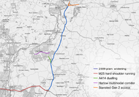
M11 and A120 interchange ? Stansted generation 2 airport access
[
edit
]
Stansted generation 2 airport access
 A map showing the proposed road development at the entry to Stansted Airport.
|
| Location
| Essex
|
|---|
| Proposer
| Highways Agency
|
|---|
| Status
| suspended
|
|---|
| Type
| Road
|
|---|
| Cost estimate
| £131 million
|
|---|
A joint scheme involving works on junctions on the M11 and
A120
. This scheme was part of an aborted plan to add a second runway to Stansted Airport. It proposed changes to junction 8 of the M11 with the creation of junction 8B, linked to and situated just north of junction 8/8A and the creation of a new junction on the A120, to provide additional rapid access to the expanded airport.
[21]
The scheme was given an estimated cost of £131
million in May 2008.
[22]
Throughout 2007, a number of public consultations and exhibitions were held. Findings from these showed that although the public had several concerns regarding environmental impact 57% of attendees agreed the scheme would be necessary if the Stansted Airport expansion proceeded.
[21]
Following the public consultation, the preferred route was published on 5 March 2008 and the draft orders on 27 March 2008. A pre-public inquiry meeting took place on 10 November 2008,
[23]
with a public inquiry due in April 2009.
[24]
However, this was delayed until further notice following BAA's appeal against the
March 2009 ruling
of the Competition Commission and the proposal lapsed when the application for a second runway was withdrawn by BAA in 2010.
[25]
[26]
Incidents
[
edit
]
Plane crash
[
edit
]
On 2 June 2002, a brake failure on an
Aero L-39 Albatross
landing at the
Imperial War Museum Duxford
caused the plane to run off the end of the runway and down an embankment onto the southbound carriageway of the motorway. The trainee pilot was killed when he
ejected
at ground level, but the instructor survived the accident and no vehicles on the motorway were involved.
[27]
The main runway at Duxford had been shortened in 1977 from 6,000 feet (1,800 m) to 4,800 feet (1,500 m) when the motorway was built. More recently, even though Duxford already met all licensing requirements, the declared length was reduced to 4,010 feet (1,220 m) to increase safety further than existing measures.
[28]
[29]
Snow storm
[
edit
]
In January 2003, thousands of motorists became stranded on "White Friday" for up to 20
hours between junctions 7 and 9 during a snowstorm.
[30]
Junctions
[
edit
]
Data from
driver location signs
are used to provide distance and carriageway identifier information.
[31]
| M11 motorway junctions
|
| mile
|
km
|
Southbound exits (B carriageway)
|
Junction
|
Northbound exits (A carriageway)
|
Coordinates
|
| 7.5
|
12.1
|
North Circular
A406 (West)
(A10, A1),
West End
The City
,
Docklands
,
Blackwall Tunnel
(
A12, A13
),
A406 South
|
J4
|
Start of motorway
|
51°35′52″N
0°02′38″E
/
51.5978°N 0.0438°E
/
51.5978; 0.0438
(
M11, Junction 4 - start of motorway
)
|
|
|
|
Entering
Greater London
|
|
Entering
Essex
|
|
| 11.4
|
18.4
|
No access
|
J5
|
Debden
,
Loughton
A1168
|
51°38′25″N
0°05′03″E
/
51.6404°N 0.0842°E
/
51.6404; 0.0842
(
M11, Junction 5
)
|
| 14.7
|
23.6
|
Watford
,
Oxford
,
Heathrow Airport
,
M1
,
M40
,
M4
M25(W)
Gatwick Airport
,
Dartford Crossing
,
M23
,
M20
M25(E)
|
J6
|
Watford, Oxford, Heathrow Airport, M1, M40, M4 M25(W)
Gatwick Airport, Dartford Crossing, M23, M20 M25(E)
|
51°40′46″N
0°07′30″E
/
51.6794°N 0.1250°E
/
51.6794; 0.1250
(
M11, Junction 6
)
|
| 19.1
|
30.7
|
Chelmsford
,
Harlow
A414
|
J7
|
Harlow A414
|
51°44′36″N
0°08′16″E
/
51.7432°N 0.1377°E
/
51.7432; 0.1377
(
M11, Junction 7
)
|
| 22.6
|
36.3
|
Harlow
A1025
|
J7A
|
Harlow
A1025
|
51°47′19″N
0°10′13″E
/
51.7886°N 0.1704°E
/
51.7886; 0.1704
(
M11, Junction 7a
)
|
| 28.9
|
46.5
|
Bishop's Stortford
,
Services
,
Colchester
,
Stansted
A120
|
J8
Services
|
Bishop's Stortford, Services A120(W)
|
51°52′18″N
0°11′57″E
/
51.8717°N 0.1992°E
/
51.8717; 0.1992
(
M11, Junction 8
)
|
| 29.2
|
47.0
|
No access
|
J8A
|
Stansted, Colchester A120(E)
|
51°52′08″N
0°11′50″E
/
51.8689°N 0.1972°E
/
51.8689; 0.1972
(
M11, Junction 8a
)
|
|
|
|
Entering
Essex
|
|
Entering
Cambridgeshire
|
|
| 43.3
|
69.7
|
No access
|
J9
|
Newmarket,
Norwich
,
Ipswich
M11 (A11).
|
52°03′31″N
0°11′21″E
/
52.0587°N 0.1891°E
/
52.0587; 0.1891
(
M11, Junction 9
)
|
| 29.2
|
47.0
|
No access
|
J9A
|
Saffron Walden, Cambridge South, Haverhill A1301, B184, B1383. Spur continues as A11.
|
52°04′33″N
0°11′35″E
/
52.0759°N 0.1931°E
/
52.0759; 0.1931
(
M11, Junction 9a
)
|
| 45.9
|
73.9
|
Saffron Walden
,
Duxford
,
Haverhill, Suffolk
A505
|
J10
|
Royston
, Duxford A505
|
52°05′55″N
0°08′17″E
/
52.0986°N 0.1381°E
/
52.0986; 0.1381
(
M11, Junction 10
)
|
| 50.8
|
81.7
|
Royston
A10
Cambridge
A1309
|
J11
|
Harston
A10
Cambridge
A1309
|
52°09′37″N
0°06′12″E
/
52.1602°N 0.1034°E
/
52.1602; 0.1034
(
M11, Junction 11
)
|
| 53.4
|
85.9
|
Cambridge,
Sandy
A603
|
J12
|
Cambridge, Sandy A603
|
52°11′22″N
0°04′27″E
/
52.1894°N 0.0743°E
/
52.1894; 0.0743
(
M11, Junction 12
)
|
| 55.1
|
88.6
|
No access
|
J13
|
Cambridge,
Bedford
A1303
|
52°12′42″N
0°04′39″E
/
52.2118°N 0.0776°E
/
52.2118; 0.0776
(
M11, Junction 13
)
|
| 56.2
|
90.4
|
St Neots
A428
|
J14
|
Newmarket A14
Ely (A10)
|
52°13′50″N
0°04′15″E
/
52.2306°N 0.0707°E
/
52.2306; 0.0707
(
M11, J14
)
|
|
|
|
Start of motorway
,
Non-motorway traffic
: Cambridge,
Newmarket
A14
|
|
Road continues north as
A14
towards The Midlands, which then becomes the
M6 motorway
towards The North West, and finally, the
A74(M)
in
Scotland
, and ends in
Glasgow
.
|
52°14′25″N
0°03′29″E
/
52.2404°N 0.0581°E
/
52.2404; 0.0581
(
M11, Start of motorway
)
|
In popular culture
[
edit
]
Life in the Fast Lane: The No M11 Story
(1995) is a documentary film that recounts the story of the No M11 Campaign.
See also
[
edit
]
Notes and references
[
edit
]
- Notes
- ^
An expressway inner circular, referred to as the
London Motorway Box
- ^
as the A12 which then continues to the east to
Chelmsford
and
Colchester
- ^
Constructed to the south of the not-yet built M25 interchange by
W. & C. French Engineering
, and to its north by Dowsett Engineering Construction Ltd of
Harrogate
[14]
- References
External links
[
edit
]
 Geographic data related to
M11 motorway
at
OpenStreetMap
Geographic data related to
M11 motorway
at
OpenStreetMap
KML is from Wikidata
|
|---|
| Great Britain
| | |
|---|
| Northern Ireland
| |
|---|
| Former
| |
|---|
| Unbuilt
| |
|---|
Junctions
(
 Category
) Category
)
| |
|---|
| Bridges
| |
|---|
| Related articles
| |
|---|
|