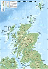
 Topographic map of Scotland
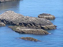
 Boreray
and the stacks from the heights of Conachair,
Hirta
Boreray
and the stacks from the heights of Conachair,
Hirta
The
outlying islands of Scotland
are not part of the larger archipelagos and island groups of Scotland?the
Hebrides
, the
Northern Isles
or the
Islands of the Forth
and
Clyde
estuaries. None of these islands are currently inhabited and few of them ever were, although
Hirta
was occupied from the
Neolithic
age until 1930 and
Stroma
was permanently occupied until the 1970s and thereafter by lighthouse keepers and their families until 1996.
[1]
[2]
Several other outlying islands have lighthouses, none of which is still staffed.
In this list, an island is defined as "land that is surrounded by seawater on a daily basis, but not necessarily at all stages of the tide, excluding human devices such as bridges and causeways".
[Note 1]
A complication relating to membership of this list is that there are various descriptions of the scope of the Hebrides, the large group of islands that lie off Scotland's west coast. The
Collins Encyclopedia of Scotland
describes the
Inner Hebrides
as lying "east of
The Minch
", which would include any and all offshore islands. There are various islands that lie in the sea
lochs
such as
Eilean Ban
and
Eilean Donan
that might not ordinarily be described as "Hebridean" but no formal definitions exist and for simplicity they are included in the
List of Inner Hebrides
rather than here.
[5]
Main islands
[
edit
]
 Mugdrum
seen from
Newburgh
Mugdrum
seen from
Newburgh
 Soay, St Kilda
, the westernmost island of Scotland (excluding
Rockall
, the status of which is a matter of dispute)
Soay, St Kilda
, the westernmost island of Scotland (excluding
Rockall
, the status of which is a matter of dispute)
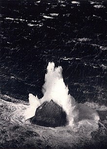 Winter waves breaking over
Rockall
in 1943
Winter waves breaking over
Rockall
in 1943
 Sula Sgeir
 The westernmost of the
Flannan Isles
: Eilean a' Ghobha and Roareim with Brona Cleit in the distance
The westernmost of the
Flannan Isles
: Eilean a' Ghobha and Roareim with Brona Cleit in the distance
 The
Rabbit Islands
The
Rabbit Islands
 Stac an Armin
with
Boreray
to the left and
Stac Lee
beyond at right
Stac an Armin
with
Boreray
to the left and
Stac Lee
beyond at right
 Stac Levenish
cliff's face silhouette
Stac Levenish
cliff's face silhouette
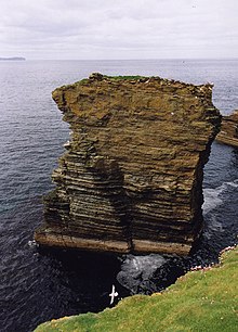 Castle Mestag,
Stroma
Castle Mestag,
Stroma
 Stac Biorach
(at left) and Stac Soay between
Hirta
and
Soay
Stac Biorach
(at left) and Stac Soay between
Hirta
and
Soay
There are several small groupings of outlying islands involved. The most significant of these is the
St Kilda
archipelago
[Note 2]
which lies 64 kilometres (40 mi) west-northwest of North Uist and is now a
World Heritage Site
. It is one of the few to hold joint status for its natural and cultural qualities.
[8]
[Note 3]
At 196 metres (643 ft)
Stac an Armin
is the highest
sea stack
in the British Isles
[10]
[11]
[12]
and in July 1840, the last
great auk
seen in the British Isles was captured there.
[13]
East of St Kilda are the
Flannan Isles
, where all three lighthouse keepers mysteriously vanished without trace in December 1900.
[14]
Further north and east are the two outliers of
Sula Sgeir
and
North Rona
, which have strong cultural links to the
Outer Hebrides
. North Rona is 71 kilometres (44 mi) north north east of
Butt of Lewis
and 18 kilometres (11 mi) east of Sula Sgeir. It is the remotest island in the
British Isles
ever to have been inhabited on a long-term basis. It is also closer than any other part of Scotland to the
Faroe Islands
.
Sule Skerry
and
Sule Stack
lie further east and are administratively part of
Orkney
.
The islands of the north coast are remote from the main centres of population, although they mostly lie close to the mainland. There is a small group of larger islands near
Tongue Bay
, but the largest on this coast is Stroma in the
Pentland Firth
, between
Caithness
and Orkney.
Innis Mhor
in the
Dornoch Firth
is the largest of a handful of small islets off the coast of
Easter Ross
. Further south are
Inchcape
off the coast of
Angus
, and
Mugdrum
, the only substantial island in the
Firth of Tay
. There is a cluster of islands in the
Solway Firth
that marks the south western border of Scotland, including the Islands of Fleet, in
Wigtown Bay
.
Most of the smaller islets that surround those in the main list are obscure and none have been permanently inhabited in modern times. Nonetheless, some have a degree of historical significance. Castle Mestag off Stroma is the ruins of a once fortified stack accessible only via a drawbridge.
[15]
[Note 4]
Some islets are identified as "storm washed", meaning that although they are partly above
mean sea level
, large waves wash over the top of them during storms, rendering them uninhabitable.
Finally, there is remote
Rockall
, which is 367 kilometres (228 mi) to the west of
North Uist
. It is a small rocky islet in the North Atlantic which could be, in
James Fisher
's words, "the most isolated small rock in the oceans of the world"
[17]
[Note 5]
and which was declared part of Scotland by the
Island of Rockall Act 1972
.
[19]
[20]
However, the legality of the claim is disputed by the Republic of Ireland, Denmark and Iceland and it is probably unenforceable in international law.
[21]
[22]
[Note 6]
| Island
|
Group
|
Area (
ha
)
[24]
|
Height (m)
[25]
[Note 7]
|
Light
[Note 8]
|
Last inhabited
[Note 9]
|
Surrounding islets
|
| Ardwall Isle
|
Islands of Fleet
|
22
|
34
|
No
|
18th century?
[Note 10]
|
Old Man of Fleet
|
| Barlocco Isle
|
Islands of Fleet
|
10
|
10
|
No
|
Inhabitation unlikely
|
The Three Brethren
|
| Big Scare
|
Solway Firth
[28]
|
<1
|
21
[29]
|
No
|
Inhabitation very unlikely
|
Little Scares (3)
|
| Boreray
|
St Kilda
|
77
|
384
|
No
|
Iron Age
?
[Note 11]
|
An t-Sail, Sgarbhstac
|
| Brona Cleit
|
Flannan Isles
|
1
|
c. 20
|
No
|
Inhabitation very unlikely
|
None
|
| Dun
|
St Kilda
|
32
[32]
|
178
|
No
|
Unknown
[Note 12]
|
Hamalan, Giasgeir, Sgeir Cul an Rubha, Sgeir Mhor
|
| Eilean a' Ghobha
|
Flannan Isles
|
8
|
57
|
No
|
Inhabitation very unlikely
|
None
|
| Eilean Choraidh
|
Loch Eriboll
|
26
[34]
|
26
|
No
|
1930s
|
A' chleit
|
| Eilean Hoan
|
Loch Eriboll
|
28
[34]
|
25
|
No
|
Early 1800s
[35]
|
A' Ghoil-sgeir, An Cruachan, An Dubh-sgeir, Eilean Cluimhrig, Pocan Smoo
|
| Eilean Mor
|
Flannan Isles
|
17.5
[36]
[Note 13]
|
88
|
Yes
|
1971
[38]
|
Deirc na Sgeir, Lamh a Sgeir Beag, Lamh an Sgeir Moire
|
| Eilean nan Ron
|
Tongue Bay
|
138
|
76
|
No
|
1930s or 40s
[Note 14]
|
An Innis, Eilean Iosal, Meall Thailm
|
| Eilean Taighe
|
Flannan Isles
|
11
|
59
|
No
|
Unknown
[Note 15]
|
Gealtaire Beag, Gealtaire Mor, Hamasgeir
|
| Hestan Island
|
Solway Firth
|
c.11
|
54
|
Yes
|
Unknown
[Note 16]
|
None
|
| Hirta
|
St Kilda
|
670
|
430
|
No
|
1930
|
An Torc, Bradastac, Mina Stac, Sgeir Domhnuill, Sgeir Mhor, Sgeir nan Sgarbh
|
| Inchcape
|
Angus
coast
|
0.61
[41]
|
0
[Note 17]
|
Yes
|
1988
[Note 18]
|
None
|
| Innis Mhor
|
Easter Ross
|
26
|
<5
|
No
|
Shifting sands
|
None
[Note 19]
|
| Little Ross
|
Solway Firth
|
7
|
35
|
Yes
|
Inhabitation unlikely
|
Sugarloaf
|
| Mugdrum
|
Firth of Tay
|
32
[44]
|
4
|
No
|
Inhabitation unlikely
|
None
|
| Murray's Isles
|
Islands of Fleet
|
1
[Note 20]
|
c.5
|
No
|
Inhabitation unlikely
[Note 21]
|
Horse Mark
|
| Neave Island
|
Tongue Bay
|
30
[34]
|
70
|
No
|
Unknown
[Note 22]
|
Stac an Fhamhair
|
| North Rona
|
North west
|
109
|
108
|
No
|
1885
|
Gealldraig Mhor, Loba Sgeir
|
| Rabbit Islands
|
Tongue Bay
|
32
|
45
|
No
|
Unknown
[Note 23]
|
Dubh Sgeir-Mhor, Eilean a Chaoil, Eilean Creagach, Sgeir an Oir, Talmine Island
|
| Roaireim
|
Flannan Isles
|
5
|
52
|
No
|
Inhabitation very unlikely
|
None
[Note 24]
|
| Rockall
|
North Atlantic
|
0.0624
[Note 25]
|
21.4
[48]
|
No
|
Storm washed
|
Hasselwood Rock
,
Helen's Reef
|
| Rough Island
|
Solway Firth
|
8
[49]
|
24
[49]
|
No
|
Inhabitation unlikely
|
Craig Roan, Spring Stones
|
| Sgeir Toman
|
Flannan Isles
|
4
|
43
|
No
|
Inhabitation very unlikely
|
Sgeir Righinn
|
| Soay
|
St Kilda
|
99
|
378
|
No
|
Inhabitation unlikely
[Note 26]
|
Am Plastair, Sgeir Mac Righ Lochlainn,
Stac Biorach
, Stac Dona, Stac Soay.
|
| Soraigh
|
Flannan Isles
|
6
|
41
|
No
|
Inhabitation very unlikely
|
None
|
| Stac an Armin
|
St Kilda
|
9
|
196
|
No
|
Never inhabited
[Note 27]
|
None
|
| Stac Lee
|
St Kilda
|
2.3
|
172
|
No
|
Never inhabited
|
None
|
| Stac Levenish
|
St Kilda
|
2.42
|
62
|
No
|
Never inhabited
|
Na Bodhan
|
| Stroma
|
Caithness
|
375
|
53
|
Yes
|
1996
|
Castle Mestag
|
| Sula Sgeir
|
North west
|
15
[Note 28]
|
70
|
Yes
|
Storm washed
[54]
|
Bogha Corr, Grallsgeir
|
| Sule Skerry
|
Orkney
|
16
[55]
|
12
[56]
|
Yes
|
1982
[54]
|
None
|
| Sule Stack
|
Orkney
|
2.9
[55]
|
36
[56]
|
No
|
Storm washed
|
None
|
Smaller islets off the mainland
[
edit
]
 An Garbh-eilean off the north coast near
Durness
An Garbh-eilean off the north coast near
Durness
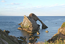 Bow Fiddle Rock
 The skerry of
Craiglethy
? one of the few east coast islands
The skerry of
Craiglethy
? one of the few east coast islands
- Solway Firth
:
Inch
- North coast
(from west to east): Stac an Dunain, Duslic, Stack Clo Kearvaig, An Garbh-eilean, Na Glas Leacan, Eilean Dubh, Clach Bheag na Faraid, Clach Mhor na Faraid, Aigeach, Eilean Polsain, Boursa Island, Glas-eilean Mor, Garbh-eilean, Wester Clett, Middle Clett, Easter Clett, Little Clett,
Clett
.
- East coast
:
- North
Moray Firth
(from north to south): The Knee, Stacks of Duncansby, Stack o' Brough, South Stack, The Stacks, Eilean na h-Aibhne,
[57]
Three Kings.
[58]
- South Moray Firth (from west to east):
Covesea Skerries
, Halliman Skerries, Boar's Head Rock, West Muck, East Muck, Craigenroan,
Bow Fiddle Rock
, Collie Rocks, Craigandargity.
- Kinnaird Head to the
Bullers of Buchan
: The Ron, The Skerry, Miekle Mackie, Miekle Donnon, Little Donnon, Craig Snow, Meikle Dumeath, Little Dumeath.
- Bullers of Buchan to Girdle Ness: Dunbuy, The Donnons, Skellyis of Harrol.
- Girdle Ness to Buddon Ness:
Craiglethy
,
Craigmaroinn
,
May Craig
.
Other than Mugdrum in the Firth of Tay and the
Islands of the Forth
there are no genuine islands on the east coast of Scotland south of Buddon Ness.
[
citation needed
]
Tidally exposed islets and skerries
[
edit
]
There are various smaller islets and
skerries
in the seas surrounding the mainland of Scotland that are only exposed at lower stages of the tide. Craiglethy is part of the
Fowlsheugh
nature reserve
. The Three Kings, off the coast of Easter Ross near
Balintore
, is also known as
Creag Harail
or Harold's Rock and called The King's Sons in the
New Statistical Account of Scotland
. According to legend, three sons of a Danish prince, sailing to avenge their sister's wrongs, were wrecked here and gave these rocks their collective name. Their graves were marked by the sculptured stones of
Nigg
, Shandwick and
Hilton of Cadboll
. Another story has their burial at Nigg Rocks below the North Sutor.
[59]
See also
[
edit
]
References and footnotes
[
edit
]
- General references
- Notes
- ^
Various other definitions are used in the Scottish context. For example, the General Register Office for Scotland define an island as "a mass of land surrounded by water, separate from the Scottish mainland" but although they include islands linked by bridges etc., this is not clear from this definition.
[3]
Haswell-Smith (2004) uses "an Island is a piece of land or group of pieces of land which is entirely surrounded by water at Lowest Astronomical Tide and to which there is no permanent means of dry access". This consciously excludes bridged islands, which most other sources include.
[4]
- ^
In addition to World Heritage Status, which none of the other outlying islands share, Hirta is by far the largest individual island (Soay and Boreray are fourth and fifth largest), and at its maximum of 180 its population was by far the largest, only Stroma coming close.
[6]
Numerous books have been written about these islands, their history and wildlife, which at one time included three unique sub-species – two
mice
and the
St Kilda wren
.
[7]
- ^
When inhabited, these islands had strong cultural ties to the Hebrides, but they are quite distinct from the Outer Hebrides geologically and Haswell-Smith (2004) lists St Kilda in "Section 9: The Atlantic Outliers".
[9]
- ^
Possibly also known as "The Robber's Castle" and said to have been a hideout of the 12th-century pirate
Sweyn Asleifsson
.
[16]
- ^
There are numerous islands that are more remote from a mainland, but not from other islands. Rockall lies "the furthest distance from any other outcrop or land of any description".
[18]
- ^
Aird an Runair, North Uist
NF686705
is the nearest place on an inhabited British island to Rockall, about 367 km (228 mi) (198 nmi) away. Gob a' Ghaill, on uninhabited
Soay, St Kilda
and the nearest point of undisputed British soil at
NA055014
is about 301 km (187 mi) (162 nmi) away.
[23]
- ^
Note that the Ordnance Survey maps mark the height above sea level of a high point on most islands, but in a small number of cases, this may not be the highest point.
- ^
Indicates the presence of a lighthouse on Ordnance Survey maps.
- ^
Indicates the last known date of permanent, year round settlement.
[26]
- ^
The Ordnance Survey indicate the remains of an 8th-century chapel, which is also the site of an 18th-century "tavern" and there is an uninhabited cottage facing the sea.
[27]
- ^
Fleming identifies a
wheelhouse
on the island.
[30]
Various tales told by the St Kildans hint at occupation in the historic period, although no concrete evidence of this has been found. There is nowhere to store a boat and any permanent residents would have been marooned there and dependent on outside assistance to leave. As a result of a smallpox outbreak on Hirta in 1724, three men and eight boys were marooned on Boreray until the following May.
[31]
- ^
The island's name means "fort" but there is only a single ruined wall of a structure said to have been built in the far-distant past by the mythical
Fir Bolg
.
[33]
- ^
According to the
Joint Nature Conservation Committee
the total land area of the Flannan Isles is 58.87 hectares (145.5 acres).
[37]
- ^
There was a population of 63 in 1891 and 30 in 1931. Uninhabited by 1951.
[39]
- ^
The name is Gaelic for "island of the house" and there is a tiny ruined structure.
[36]
- ^
There is a holiday cottage, an unmanned lighthouse and the remains of a 14th-century "Manor House".
[40]
- ^
The reef is covered by seawater at high tide and only 1.3 metres (4.3 ft) lies above water at low tides.
[41]
- ^
The lighthouse was manned from 1810 until 1988.
[42]
- ^
The nearby Innis Bheag or "Paterson Island" is now a
sand spit
joined to the
Morrich More
.
[43]
- ^
As the name implies there are two small islets separated at higher stages of the tide. The smaller islet is circa 0.25 hectares (0.62 acres).
- ^
The
Royal Commission on the Ancient and Historical Monuments of Scotland
(RCAHMS) indicate the existence of a "structure" or "wall".
[45]
- ^
The Ordnance Survey indicate the presence of a ruined chapel.
- ^
The two islands are connected to one another and the mainland at low tides and were probably inhabited at some point in the past. The Gaelic name is
Eilean nan Gall
meaning "islands of the strangers", which is thought to refer to their usage by Danish
Vikings
.
[46]
- ^
None of the very small islets are named by the Ordnance Survey.
- ^
An area estimate of 624 square metres (6,720 sq ft). The height is circa 20 metres (66 ft).
[47]
- ^
Like nearby Boreray there is nowhere to store a boat and any permanent residents would have been marooned there and dependent on outside assistance to leave. There is a primitive hut known as
Taigh Dugan
(Dugan's house). This is little more than an excavated hole under a huge stone with two rude walls on the sides. The story of its creation relates to two sheep-stealing brothers from Lewis who came to St Kilda only to cause further trouble. Dugan was exiled to Soay, where he died; the other, called Fearchar Mor, was sent to Stac an Armin, where he found life so intolerable he cast himself into the sea.
[50]
- ^
It would be impossible to maintain life for long on this precipitous crag although there are 78 storage
cleitean
and a small
bothy
used by the native St Kildan fowlers in the summer.
[51]
- ^
A figure of 124.4 hectares (307 acres) for Rona and Sula Sgeir is provided by Wood.
[52]
Haswell Smith gives 109 hectares (270 acres) for North Rona. Sula Sgeir is therefore c. 15.4 hectares (38 acres).
[53]
- Citations
- ^
Fleming (2005) "Men of Stone" pp. 37?59.
- ^
Haswell-Smith (2004) p. 336.
- ^
General Register Office for Scotland (2003) "Appendix".
- ^
Haswell-Smith (2004) "Preface" p. xi.
- ^
Keay & Keay (1994) p. 507.
- ^
Haswell-Smith (2004) p. 315, 336.
- ^
Haswell-Smith (2004) p. 318.
- ^
"Dual World Heritage Status For Unique Scottish Islands"
Archived
2006-10-02 at the
Wayback Machine
(14 July 2005) National Trust for Scotland. Retrieved 6 January 2007.
- ^
Haswell-Smith (2004) pp. 313?331.
- ^
"Corrections and clarifications"
.
The Guardian
. London. 16 April 2007
. Retrieved
5 February
2009
.
- ^
Dawson, Alan (1992).
Relative Hills of Britain
. Cicerone Press. p. 109.
ISBN
978-1-85284-068-6
.
- ^
The National Trust for Scotland has 191 m.
"St Kilda ? National Trust for Scotland World Heritage Site"
.
National Trust for Scotland
. Retrieved
5 February
2009
.
- ^
Rackwitz p. 347.
- ^
See for example, Nicholson (1995) pp. 168?79.
- ^
"Stroma, Castle Mestag"
RCAHMS
. Retrieved 7 September 2009.
- ^
"Mestag Castle, Island of Stroma, Caithness"
caithness.org. Retrieved 2 September 2009.
- ^
Fisher (1956) pp. 12?13.
- ^
Oates, John (8 April 2005)
"More North Atlantic charity madness"
The Register. Retrieved 8 September 2009.
- ^
"On This Day: 21 September"
.
BBC
. 21 September 1955
. Retrieved
1 August
2007
.
- ^
"House of Lords Hansard"
. 24 June 1997
. Retrieved
1 August
2007
.
- ^
"Oral Questions to the Minister of Foreign Affairs"
. Dail Eireann. 1 November 1973. Archived from
the original
on 22 August 2006
. Retrieved
17 January
2007
.
- ^
MacDonald, Fraser (2006).
"The last outpost of Empire: Rockall and the Cold War"
.
Journal of Historical Geography
.
32
(3): 627?647.
doi
:
10.1016/j.jhg.2005.10.009
. Archived from
the original
(pdf)
on 3 October 2011
. Retrieved
15 May
2011
.
- ^
"2.2.1.1. Location"
Archived
2009-07-05 at the
Wayback Machine
www.rockall.name Retrieved 30 July 2010.
- ^
Haswell-Smith (2004) for islands >40 ha (100 acres) and Ordnance Survey maps for islands <40 ha unless otherwise stated.
- ^
Ordnance Survey maps.
- ^
Information is from Haswell-Smith (2004) unless otherwise stated.
- ^
"Island prehistory"
onesmallisland.org.uk. Retrieved 2 September 2009.
- ^
A remote rock located at
grid reference
NX256333
.
- ^
"St Bees Head to Mull of Galloway ? pilot info"
ukriversguidebook.co.uk. Retrieved 19 July 2010.
- ^
Fleming (2005) p. 58.
- ^
Maclean (1977) pp. 48?9.
- ^
"St Kilda"
Archived
2007-07-05 at
archive.today
(pdf) United Nations Environment Programme World Conservation Monitoring Centre. Retrieved 4 August 2009.
- ^
Maclean (1977) page 29.
- ^
a
b
c
Rick Livingstone’s Tables of the Islands of Scotland
(pdf) Argyll Yacht Charters. Retrieved 12 Dec 2011.
- ^
"Place Names in Durness"
Archived
2008-05-15 at the
Wayback Machine
countysutherland.co.uk. Retrieved 29 November 2009.
- ^
a
b
Haswell-Smith (2004) p. 330.
- ^
"SPA description:Flannan Isles"
. JNCC. Retrieved 5 September 2009.
- ^
Haswell-Smith (2004) p. 331.
- ^
Haswell-Smith (2004) p. 201.
- ^
"A History of Auchencairn and District"
. www.Auchencairn.org.uk. Archived from
the original
on 27 September 2007
. Retrieved
29 April
2007
.
- ^
a
b
Nicholson (1995) p. 86.
- ^
Nicholson (1995) p. 200.
- ^
Hansom, JD and Black, SDL (1996)
"The Geomorphology of Morrich More: Management Prescription Review"
Archived
2016-03-03 at the
Wayback Machine
(pdf) SNH. Retrieved 29 November 2009.
- ^
"Historical perspective for Mugdrum Island"
.
Gazetteer for Scotland
. Retrieved
5 October
2008
.
- ^
"Murray's Isles"
Retrieved 2 September 2009
- ^
"Rabbit Islands"
www.electricscotland.com, quoting the
Ordnance Gazetteer of Scotland
, which itself refers to a survey of 1880. Retrieved 30 July 2010.
- ^
"Rockall" Full version"
Archived
2009-07-05 at the
Wayback Machine
www.rockall.name. Retrieved 31 August 2009.
- ^
Haswell-Smith (2004) p. 314.
- ^
a
b
"Rough Island"
Gazetteer for Scotland. Retrieved 31 August 2009.
- ^
See Maclean (1977) pp. 49?50 for a version of this tale.
- ^
Quine (2000) pp. 142 and 146.
- ^
Wood, L. J. (2007). MPA Global
"Rona and Sula Sgeir"
Archived
2011-07-26 at the
Wayback Machine
mpaglobal.org. Retrieved 8 September 2009.
- ^
Haswell Smith (2004) p. 326.
- ^
a
b
See
"Lighthouses"
Geograph
. Retrieved 4 September 2009.
- ^
a
b
"SPA description"
JNCC. Retrieved 8 September 2009.
- ^
a
b
"Sailing Directions (Enroute), Pub. 141, Scotland"
Archived
2009-06-18 at the
Wayback Machine
(pdf) National Geospatial-Intelligence Agency. p. 109. Retrieved 8 September 2009.
- ^
Located at
grid reference
NH577954
in the inner
Dornoch Firth
by
Carbisdale Castle
.
- ^
The Three Kings are skerries located at
grid reference
NH856725
and named on the 1992 revision of the Admiralty Chart "Dunrobin Point to Buckie".
- ^
Watson (1976) p. 54.
|
|---|
| |
|
|
|
|
Culture
|
|---|
| Shetland
| |
|---|
| Orkney
| |
|---|
| Outer Hebrides
| |
|---|
| Inner Hebrides
| |
|---|
|
|
|
Wildlife
|
|---|
| Fauna
| |
|---|
| Flora
| |
|---|
| Domesticated animals
| |
|---|
|
|
|