From Wikipedia, the free encyclopedia
List of cities in Saint Lucia by alphabetical order
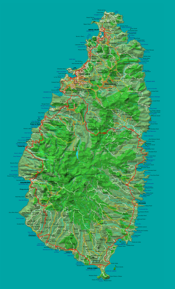 Map of Saint Lucia
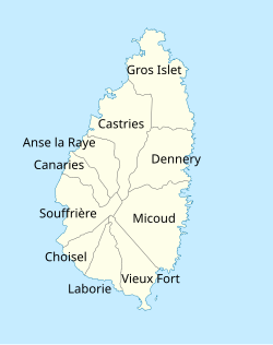 Districts of Saint Lucia
This is a
list of cities
, towns, and other inhabited places in the 10
districts
of the
island country
of
Saint Lucia
. There are 150 inhabited places in Saint Lucia. The significant cities and the district where they are located are listed below.
[1]
Cities
[
edit
]
The following are the significant cities in Saint Lucia:
[2]
Cities in Saint Lucia
| City
|
District
[2]
|
Population
[2]
|
| Anse La Raye
|
Anse la Raye District
13°56′46″N
61°02′20″W
/
13.94619°N 61.03879°W
/
13.94619; -61.03879
(
Anse La Raye
)
|
1,256
|
| Au Tabor
|
Anse la Raye District
13°56′46″N
61°02′29″W
/
13.9461°N 61.04128°W
/
13.9461; -61.04128
(
Au Tabor
)
|
451
|
| Babonneau
|
Castries District
14°00′13″N
60°56′36″W
/
14.00374°N 60.94324°W
/
14.00374; -60.94324
(
Babonneau
)
|
| Bisee
|
Castries District
14°01′27″N
60°58′28″W
/
14.02429°N 60.97445°W
/
14.02429; -60.97445
(
Bisee
)
|
12,980
|
| Bocage
|
Castries District
14°00′07″N
60°58′10″W
/
14.00199°N 60.96954°W
/
14.00199; -60.96954
(
Bocage
)
|
1,127
|
| Canaries
|
Canaries District
13°54′08″N
61°03′53″W
/
13.90224°N 61.06459°W
/
13.90224; -61.06459
(
Canaries
)
|
1,862
|
| Castries
(capital)
|
Castries District
13°59′45″N
61°00′22″W
/
13.9957°N 61.00614°W
/
13.9957; -61.00614
(
Castries
)
|
20,000
|
| Choiseul
|
Choiseul District
13°46′22″N
61°02′58″W
/
13.77273°N 61.04931°W
/
13.77273; -61.04931
(
Choiseul
)
|
346
|
| Dennery
|
Dennery District
13°54′51″N
60°53′29″W
/
13.91409°N 60.89132°W
/
13.91409; -60.89132
(
Dennery
)
|
2,870
|
| Gros Islet
|
Gros Islet District
14°04′00″N
60°57′00″W
/
14.06667°N 60.95°W
/
14.06667; -60.95
(
Gros Islet
)
|
2,362
|
| Laborie
|
Laborie District
13°45′00″N
60°59′00″W
/
13.75°N 60.98333°W
/
13.75; -60.98333
(
Laborie
)
|
1,131
|
| Marigot Bay
|
Castries District
13°57′50″N
61°01′34″W
/
13.96376°N 61.02598°W
/
13.96376; -61.02598
(
Marigot Bay
)
|
799
|
| Micoud
|
Micoud District
13°49′00″N
60°54′00″W
/
13.81667°N 60.9°W
/
13.81667; -60.9
(
Micoud
)
|
3,406
|
| Mon Repos
|
Micoud District
(formerly
Praslin Quarter
)
13°51′35″N
60°54′08″W
/
13.85977°N 60.90225°W
/
13.85977; -60.90225
(
Mon Repos
)
|
982
|
| Monchy
|
Gros Islet District
14°03′11″N
60°55′48″W
/
14.05319°N 60.92987°W
/
14.05319; -60.92987
(
Monchy
)
|
416
|
| Praslin
|
Micoud District
13°52′32″N
60°53′50″W
/
13.87545°N 60.89717°W
/
13.87545; -60.89717
(
Praslin
)
|
1,906
|
| Ravine Poisson
|
Castries District
13°55′54″N
60°58′07″W
/
13.93156°N 60.96849°W
/
13.93156; -60.96849
(
Ravine Poisson
)
|
560
|
| Rodney Bay
|
Gros Islet District
14°04′23″N
60°57′16″W
/
14.07292°N 60.95443°W
/
14.07292; -60.95443
(
Rodney Bay
)
|
509
|
| Roseau
|
Anse la Raye District
13°57′13″N
61°01′28″W
/
13.95368°N 61.02442°W
/
13.95368; -61.02442
(
Roseau
)
|
|
| Soucis
|
Castries District
13°58′39″N
60°59′57″W
/
13.97751°N 60.99922°W
/
13.97751; -60.99922
(
Soucis
)
|
619
|
| Soufriere
|
Soufriere District
13°51′22″N
61°03′24″W
/
13.85616°N 61.0566°W
/
13.85616; -61.0566
(
Soufriere
)
|
2,918
|
| Ti Rocher, Castries
|
Castries District
13°59′42″N
60°58′16″W
/
13.9949°N 60.9711°W
/
13.9949; -60.9711
(
Ti Rocher
)
|
647
|
| Ti Rocher, Micoud
|
Micoud District
13°49′02″N
60°55′43″W
/
13.81734°N 60.92858°W
/
13.81734; -60.92858
(
Ti Rocher
)
|
980
|
| Vieux Fort
|
Vieux Fort District
13°43′00″N
60°57′00″W
/
13.71667°N 60.95°W
/
13.71667; -60.95
(
Vieux Fort
)
|
4,574
|
See also
[
edit
]
References
[
edit
]
|
|---|
| Sovereign states
| |
|---|
Dependencies and
other territories
| |
|---|
