Subgroup of islands in the West Indies
The
Leeward Islands
(
) are a group of islands situated where the northeastern
Caribbean Sea
meets the western Atlantic Ocean. Starting with the
Virgin Islands
east of
Puerto Rico
, they extend southeast to
Guadeloupe
and its dependencies. In English, the term
Leeward Islands
refers to the northern islands of the
Lesser Antilles
chain. The more southerly part of this chain, starting with
Dominica
, is called the
Windward Islands
. Dominica was originally considered a part of the Leeward Islands, but was transferred from the
British Leeward Islands
to the
British Windward Islands
in 1940.
Origin of the name
[
edit
]
 Charlotte Amalie
,
Saint Thomas
, in the
U.S. Virgin Islands
Charlotte Amalie
,
Saint Thomas
, in the
U.S. Virgin Islands
 Overlooking
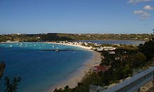
Sandy Ground
,
Anguilla
Overlooking
Sandy Ground
,
Anguilla
The name of this island group,
Leeward Islands
, dates from previous centuries, when
sailing ships
were the sole form of transportation across the Atlantic Ocean. In sailing terminology, "
windward
" means towards the source of the wind (upwind), while "
leeward
" is the opposite direction (downwind). In the
West Indies
, the prevailing winds, known as the
trade winds
, blow predominantly out of the northeast. Therefore, a sailing vessel departing from the
British Gold Coast
and the
Gulf of Guinea
, driven by the trade winds, would normally first encounter Dominica and Martinique,
[1]
islands most to windward, in their west-northwesterly heading to the final destinations in the
Caribbean
,
Central America
, and
Northern America
.
[2]
This location, Dominica and Martinique, becomes the rough dividing line between the Windward Islands and the Leeward Islands.
The early
Spanish explorers
called
Puerto Rico
and the islands to the west
Sotavento
, meaning "leeward". The islands to the south and east of Puerto Rico were then called
Islas de Barlovento
, meaning "windward islands". When the British gained control of many of the
Lesser Antilles
, they designated
Antigua
,
Montserrat
and the islands to the north as the Leeward Islands.
Guadeloupe
and the islands to the south were designated as the Windward Islands. Later on, all islands north of
Martinique
became known as the Leeward Islands.
[3]
Dominica
was transferred to the
British Windward Islands
in 1940, and is now considered part of the
Windward Islands
.
[4]
However, even in modern usage in languages other than English, notably, Dutch, French, and Spanish, all of the Lesser Antilles from the
Virgin Islands
to
Trinidad and Tobago
are known as the Windward Islands (
Bovenwindse Eilanden
in Dutch,
Iles du Vent
in French, and
Islas de Barlovento
in Spanish). The
ABC islands
and the other islands along the Venezuelan coast, known in English as the
Leeward Antilles
, are known in languages other than English as an equivalent of the Leeward Islands.
Geography
[
edit
]
 The Leeward Islands are labelled on the map's middle right side
The islands were created mostly by
volcanoes
in the
Lesser Antilles subduction zone
. Some are still active. Notable eruptions occurred in
Montserrat
in the 1990s and in 2009 to 2010. At 1,467 metres or 4,813 feet, the highest point is
La Grande Soufriere
in
Guadeloupe
.
History
[
edit
]
The
Caribs
, after whom the
Caribbean
is named, are believed to have migrated from the
Orinoco
River area in Venezuela in
South America
to settle in the
Caribbean islands
about 1200 AD, according to
carbon dating
. Over the century leading up to
Columbus
' arrival in the Caribbean archipelago in 1492, the Caribs mostly displaced the
Maipurean
-speaking
Tainos
, who settled the island chains earlier in history, by warfare, extermination and assimilation.
[5]
The islands were among the first parts of the Americas to fall under the control of the
Spanish Empire
. European contact commenced with
Christopher Columbus
's second voyage; many of the islands' names originate from this period: Montserrat was named in honour of
Santa Maria de Montserrat
(Our Lady of Montserrat), after the
Blessed Virgin
of the
Monastery of Montserrat
, which is located on the
Mountain of Montserrat
, the national shrine of
Catalonia
.
Mont serrat
in
Catalan
means "
saw
mountain", referring to the serrated appearance of the mountain range.
British colony of the Leeward Islands
[
edit
]
The Leeward Islands became a
British
colony in 1671, with
William Stapleton
as its first governor.
Although comparatively much smaller than the surrounding islands in the Caribbean, the Leeward Islands posed the most significant rebellion to the British
Stamp Act
, though it was decidedly less severe in comparison to that of the mainland North American colonies.
[6]
In 1660, there were about 8,000 white settlers and approximately 2,000 African slaves in the Leeward Islands. However, that ratio narrowed over succeeding years. In 1678, there were 10,408 white settlers and 8,449 black slaves. By 1708, there was a huge disparity between the number of white settlers, which had declined to 7,311, while the number of black slaves was estimated at 23,500.
[7]
In 1816, the colony as a federation of islands was dissolved, and the individual islands were ruled individually. However, the colony of the Leeward Islands was re-established in 1833.
[8]
List of notable islands in the Leeward Islands
[
edit
]
There are two countries and eleven territories in the Leeward Islands. From the northwest to the southeast, the main islands are:
See also
[
edit
]
References
[
edit
]
- ^
"Windward Islands Map ? Leeward Islands Map ? Satellite Image"
.
geology.com
. Retrieved
2020-11-20
.
- ^
Sauer, Carl O. (1966).
The Early Spanish Main
. Berkeley: University of California Press. p. 192.
The current convention that the Leeward Islands (Sotavento) run from Guadeloupe to St. Croix records the Spanish practice of sailing to their leeward and may go back to the time of Columbus [who arrived at the Dominica Passage on his 2nd voyage]
- ^
J. C. Hart and W. T. Stone (1982),
A Cruising Guide to the Caribbean and the Bahamas
, Dodd, Mead & Co., p. 601,
ISBN
0-396-08023-5
.
- ^
"The Leewards"
.
The New York Times
. 20 December 1964.
ISSN
0362-4331
. Retrieved
11 November
2021
.
The Leeward Islands, a cluster of isles in the Caribbean under United States, British, Dutch and French flags, are strung out in a 400-mile?long arc between Puerto Rico and Martinique. The group takes its name from the geographic fact that it is farther from the direct route of the rain?carrying northeasterly trade winds than the neighboring Windward Islands. One of the islands, Dominica, is geographically part of the Leewards, but, since 1940, has been politically and administratively part of the British Windioard Islands.
- ^
Sweeney, James L. (2007). "Caribs, Maroons, Jacobins, Brigands, and Sugar Barons: The Last Stand of the Black Caribs on St. Vincent"
Archived
2012-02-27 at the
Wayback Machine
,
African Diaspora Archaeology Network
, March 2007, retrieved 26 April 2007.
- ^
O'Shaughnessy, Andrew (April 1994). "The Stamp Act Crisis in the British Caribbean".
The William and Mary Quarterly
.
51
(2): 203?226.
doi
:
10.2307/2946860
.
JSTOR
2946860
.
S2CID
144862560
.
- ^
Hilary Beckles, "The 'Hub of Empire': The Caribbean and Britain in the Seventeenth Century",
The Oxford History of the British Empire: Volume 1 The Origins of Empire
, ed. by Nicholas Canny (Oxford: Oxford University Press, 2001), p. 224.
- ^
"LC Name Authority File (LCNAF) ? Leeward Islands (Federation)"
.
id.loc.gov
. The Library of Congress
. Retrieved
23 December
2020
.
- ^
The American Universal Geography, Jedidiah Morse, 7ed. v1, Charlestown, 1819.
Further reading
[
edit
]
External links
[
edit
]
|
|---|
| International
| |
|---|
| National
| |
|---|
| Other
| |
|---|