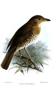
 Comoro thrushes live in the IBA
La Grille
is a
volcano
in the
Comoros archipelago
on the island of
Grande Comore
(also known as
Ngazidja
).
Description
[
edit
]
La Grille is a shield volcano at the northern end of island and lacks a summit caldera like its larger and more well-known neighbour to the south,
Karthala volcano
. The
basaltic
La Grille volcano also differs from Karthala in its abundance of
pyroclastic cones
up to 800 m (2,625 ft) in height. The cones were erupted along
fissures
running parallel to the summit ridge, which has an irregular profile and is elongated in a north-south direction, and from radial fissures that reach as far as the coast. Although the exact date of the last eruption of La Grille is unknown, lava flows covering its sides and not yet recolonized by vegetation suggest that the volcano last erupted only a few hundred years ago. Recent
lava flows
, some possibly as young as a few hundred years, have reached the sea from fissures on the lower western, northern, and eastern flanks.
[1]
Geography
[
edit
]
La Grille is located on the island of Grande Comore, a northern island of the Comoros archipelago in the
Mozambique Channel
in the Indian Ocean. The volcano is abutted on the south by
Karthala
, another volcano rising to 2,361 m (7,746 ft) meters. A road around the coast of Grande Comore runs along the east, north and west sides of La Grille, connecting
Prince Said Ibrahim Airport
to the west of the island. Many villages are located near the coast and on the volcano, where there are also electricity pylons.
La Grille appears as a mountain range running from north to south, reaching a slag height of 800 m (2,625 ft) meters on average, and covered in
stratovolcano
cones,
[2]
giving the volcano a maximum altitude of 1,087 m (3,566 ft) meters.
[1]
Unlike its neighbour Karthala, La Grille does not have
caldera
. Different eruptive
vents
are located along the fissures that run along the volcano from north to south, parallel to the ridge of the mountain, and other cracks along the coast. Lava basalt sometimes escapes from these eruptive vents, sometimes reaching the sea to the east, north and west sides of the volcano. Many lava flows are still visible as few are rapidly recolonized by tropical Coconut trees on the island.
Important Bird Area
[
edit
]
An 8,725 ha tract encompassing the higher slopes and summit of the mountain has been designated an
Important Bird Area
(IBA) by
BirdLife International
because it supports populations of
Comoro olive pigeons
,
Comoro blue pigeons
,
Malagasy harriers
,
Grand Comoro brush warblers
,
Grand Comoro bulbuls
,
Comoro thrushes
,
Humblot's sunbirds
and
red-headed fodies
.
[3]
References
[
edit
]
11°28′S
43°20′E
/
11.47°S 43.33°E
/
-11.47; 43.33