Municipality in Thrace, Greece
Komotini
(
Greek
:
Κομοτην?
,
Turkish
:
Gumulcine
) is a city in the
region
of
East Macedonia and Thrace
, northeastern
Greece
and its capital. It is also the capital of the
Rhodope
. It was the administrative centre of the
Rhodope-Evros super-prefecture
until its abolition in 2010, by the
Kallikratis Plan
. The city is home to the
Democritus University of Thrace
, founded in 1973. Komotini is home to a sizeable Turkish speaking
Muslim
minority. They were excluded from the
1923 population exchange.
According to the 2021 census, the municipality of Komotini had population of 65,243 citizens.
[2]
Built at the northern part of the plain bearing the same name, Komotini is one of the main administrative, financial and cultural centers of northeastern Greece and also a major agricultural and breeding center of the area.
[3]
It is also a significant transport interchange, located 795 km NE of
Athens
and 281 km NE of
Thessaloniki
. The presence of the
Democritus University of Thrace
makes Komotini the home of thousands of Greek and international students and this, combined with an eclectic mix of Western and Oriental elements in the city's daily life, have made it an increasingly attractive tourist destination.
[3]
History
[
edit
]
Antiquity
[
edit
]
Komotini has existed as a settlement since the 2nd century AD. That is confirmed by archaeological finds of that era up until the 4th century. It is also confirmed by an inscription on the ruins of the 4th-century
Byzantine
wall, that are visible at various sites in the city, which reads "
Theodosiou Ktisma
" = Building of Theodosius. The inscription was discovered by the Komotini-born Prof.
Stilponas Kyriakidis
and the then mayor Sofoklis Komninos. It is said that the settlement originates from the 5th century and is linked to the daughter of the painter Parrasios from
Maroneia
. During the
Roman age
it was one of several fortresses along the
Via Egnatia
highway which existed in the Thrace area. Probably it is to be identified with the Roman station
Breierophara
(a
Thracian
toponym from bre (=fortress) + iero (= holy) + phara=para (=pass).
[4]
The most important city of that period was neighbouring
Maximianopolis
, former Thracian Porsulis or Paesoulae, which was renamed to
Mosynopolis
in the 9th century. Komotini was a Via Egnatia hub on its northern route through the Nymphaea Pass which led to the Ardas Valley, Philippopolis (modern
Plovdiv
) and Byzantine Berroe (modern
Stara Zagora
).
Byzantine era
[
edit
]
 Part of the Byzantine fortress of Komotini.
 Fortress of Komotini, the remaining foundations of the 19th century Jewish synagogue Beth El demolished in 1994.
 View of the
clock tower
.
View of the
clock tower
.
The city's history is closely connected with that of
Via Egnatia
, the Roman trunk road which connected
Dyrrhachium
with
Constantinople
. The Roman emperor
Theodosius I
built a small rectilinear fortress on the road at a junction with a route leading north across the
Rhodope Mountains
toward
Philippopolis
. During the Byzantine period, the city belonged to the
Theme of Macedonia
, whilst from the 11th century it could be found within the newly founded theme of
Boleron
. For most of its early existence the settlement was overshadowed by the larger town of
Mosynopolis
to the west, and by the end of the 12th century, the place had been completely abandoned.
The current settlement dates to 1207, when, following the destruction of Mosynopolis by the
Bulgarian
tsar
Kaloyan
, the remnant population fled and established themselves within the walls of the abandoned fortress.
Since then the population had been increasing continuously until it became an important town within the area. In 1331
John Kantakouzenos
referred to her as
Koumoutzina
in his account of the
Byzantine civil war of 1321?1328
.
[6]
In 1332
Andronikos III Palaiologos
set camp in Komotini to face
Umur Bey
of
Smyrna
at the Panagia village close to the Panagia Vathirryakos (Fatirgiaka) monastery. However, Umur departed without a battle. In 1341 the historian Nikephoros Phokas referred to the town with its current name. In 1343, during the
civil war
between John VI Kantakouzenos and
John V Palaiologos
, Komotini along with the neighbouring forts of Asomatos, Paradimi, Kranovouni and Stylario joined Kantakouzenos' side. John VI Kantakouzenos escaped to Komotini to survive from a battle with the army of the Bulgarian brigand
Momchil
near the already ruined Mosynopolis.
Ottoman era
[
edit
]
 Old tobacco warehouses
The city was conquered by the
Ottoman Empire
between 1361 and 1362/3, apparently by
Gazi Evrenos Bey
. Its conquest is placed after the fall of Philippopolis and Stara Zagora, but before the Ottoman capture of
Pegae
.
Already before that, it was called in Turkish as
Gumulcine
, a version of the demotic Greek form of the city's name, Koumoutsinas. This remained the city's name throughout the Ottoman period (ca. 1361?1912) and continues as its modern Turkish-language name today.
The city continued to be an important hub connecting the capital city of
Constantinople
with the European part of the Empire, and grew accordingly. Many monuments in the city today date to this era. Many local Greek families fled at that time to
Epirus
and founded the
Koumoutzades
village (modern Ammotopos, Arta). Even there they were persecuted by the Ottomans and some of them found refuge in Tropaia of
Gortynia
. The bond between the inhabitants of Komotini, Ammotopos and Tropaia exists to this day.
In the first two decades after its conquest, until 1383, the city was the seat of a frontier march (
uc
) under Evrenos, confronting the
Serbian
territories of
Macedonia
. The walled city continued to be inhabited by locals, Gazi Evrenos also brought in Turkish settlers to the countryside around the town to stop any riots. During the prevailingly Ottoman rule of the area, it appears that the region was largely supported, and subsequent Ottoman censuses show that Muslim Turks quickly became the dominant element in the rural districts around the city. Evrenos also invested in the city as building
camiiye
(small mosque), an
imaret
,
bath
, and shops outside the city walls, establishing a
waqf
that according to Machiel Kiel became the "nucleus of Islamic life in Western Thrace". The 16th-century geographer
Mehmed-i Ashik
also mentions a hostel (
imaret
) built by Evrenos.
In the 1519 census, the city numbered 393 Muslim households and 197 single (unmarried or widowed) Muslims, 42 Christian households and 14 single Christians, and 19 Jewish households and 5 single Jews, in total ca. 2,500 people. In the 1530 census, the 17 Turkish-named neighbourhoods (
mahalle
) are mentioned, as well as the existence of one
Friday mosque
, 16
masjids
, 4
zawiyas
, 4 schools, and a single church (in the walled city). Nevertheless, the French traveller Pierre Bellon du Mans, who visited the city in 1548, stated that "the city is inhabited by a few Greeks and majority Turks".
In the 1600s, the town was graced by new buildings?a small Friday mosque, a double bath, a
mekteb
, a
madrasah
, and an
imaret
?by the
defterdar
Ekmekcizade Ahmed Pasha
, who sponsored numerous such works throughout
Thrace
. Ahmed's mosque, the
Yeni Mosque
, which survives to this day, is the only structure in Greece to feature
Iznik tiles
from the 1580s, the zenith of the Iznik potters' art.
When the traveller
Evliya Celebi
visited the town in 1667/8, he found "4,000 prosperous, stone-built houses"?likely an exaggeration?in 16
mahalles
, with 5 main mosques, 11
masjids
, 2
imarets
, 2 baths, 5
madrasahs
(only
one
of which survives today), 7
mektebs
, 17
caravanserais
, and 400 shops.
The town suffered greatly from repeated plague epidemics, which led to entire villages being abandoned, but recovered in the 19th century.
During the
Greek War of Independence
Komotini's inhabitants contributed substantially with Ioannikios (later bishop), Aggelis Kirzalis and Captain Stavros Kobenos (members of the
Filiki Eteria
organisation). During the following decades Komotini progressed financially due to the processing and trade of tobacco.
The 19th century saw the city expand and considerable architectural activity, with the renovation of old and the construction of new buildings. Both the Yeni Mosque and Evrenos' original
masjid
, the
Eski Mosque
, were enlarged by the addition of spacious prayer halls, while Sultan
Abdulhamid II
erected a clock tower and a
madrasah
. During his reign, the town became a station in the railway linking Constantinople with
Salonica
.
By the 1880s, the city, capital of the homonymous
sanjak
in the
Edirne Vilayet
, boasted 13,560 inhabitants, 10 Friday mosques, 15
masjids
, 2 Greek and one Armenian church, a synagogue, 4
madrasahs
, two higher schools, ten
mektebs
, and various other Christian and Jewish schools.
Balkan Wars and World War I
[
edit
]
 The Greek mission in Komotini after the incorporation of the area (1920)
During the
First Balkan War
, Bulgarian forces captured the city, only to surrender it to the
Greek army
during the
Second Balkan War
on July 14, 1913.
In the aftermath of the Second Balkan War, it became briefly the capital of the short-lived
Provisional Government of Western Thrace
,
but the
Treaty of Bucharest
, however, handed the city back to
Bulgaria
. The city was part of Bulgaria until the end of
World War I
. During this period, the city had the Bulgarian name Гюмюрджина
Gyumyurd?ina
. In 1919 after the end of WWI, with the
Treaty of Neuilly
, Komotini was handed to Greece, along with the rest of Western Thrace.
Demographics
[
edit
]
The population is quite multilingual for a city of its size and it is made up of local
Greeks
,
Greek refugees
from
Asia Minor
and
East Thrace
,
Muslim
population of
Turkish
,
Pomak
,
Greek
and
Roma
origins, descendants of refugees who survived the
Armenian genocide
, and
Pontic Greeks
from north-eastern Anatolia and the regions of the former
Soviet Union
(mainly
Georgia
,
Armenia
,
Russia
and
Kazakhstan
).
[
citation needed
]
The Muslim population of Western Thrace dates to the
Ottoman
period, and unlike the Muslim population in other regions of Greece were exempted from the 1922-23
Greek-Turkish population exchange
following the
Treaty of Lausanne
.
[9]
Komotini has the highest percentage of Muslims in any city of the European Union (54.77% - metro area)
[10]
[
better source needed
]
Modern Komotini
[
edit
]
 View of a central street.
 Komotini's centre with the Prefecture building.
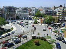
 Central square
 Traditional street.
Komotini is, nowadays, a thriving commercial and administrative centre. It is heavily centralised with the majority of commerce and services based around the historical core of the city. Getting around on foot is therefore very practical. However, traffic can be remarkably heavy due to the daily commute. In the past, the
Trelohimaros
river used to flow through the city and divide it into two parts. In the 1970s, after repeated flooding episodes the river was eventually diverted and flows on the east of the city, while its former bed has been replaced by the main avenues of the city, such as the Orfeos Street.
[
citation needed
]
Heart of the City
[
edit
]
At the heart of the city lie the evergreen Municipal Central Park and the 15 m-high WW2 Heroes' Memorial, locally known as 'The Sword'. The revamped Central square or
Plateia Irinis
(Square of Peace) is the focus of a vibrant nightlife boosted by the huge number of students living in the city. The Old commercial centre is very popular with tourists as it houses traditional shops and workshops that have long vanished from other Greek cities. In addition, in the northwestern outskirts of the city (Nea Mosinoupoli) locals and tourists alike flock into a modern shopping plaza: Kosmopolis Park, which houses department stores, shops, supermarkets, a cinema complex, cafes and restaurants. The area stretching from Kosmopolis to Ifaistos is gradually becoming a retail destination in its own right.
[
citation needed
]
Culture and Entertainment
[
edit
]
Komotini began life as a Byzantine Fortress built by the Emperor Theodosius in the 4th century AD. The ruins of this quadrangular structure can still be found NW of the central square. Komotini has several museums including the
Archaeological
, Byzantine and Folklore museums. SW of the central square one can find the Open-air Municipal Theatre, which hosts many cultural shows and events such as the cultural summer (πολιτιστικ? καλοκα?ρι =
politistiko kalokairi
). There is a Regional Theatre (DIPETHE) whose company produces many plays all year round. 6 kilometres (4 miles) NE of Komotini is the Nymfaia forest. It has recreational facilities which comprise trails, courts, playgrounds and space for
environmental studies
. The forest is divided by a paved road which leads to the ruins of yet another Byzantine fortress and the historical (WWII) fort of Nymfaia.
[
citation needed
]
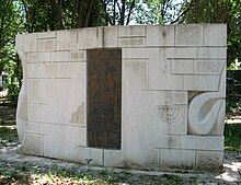 The monument for the
Holocaust
.
The monument for the
Holocaust
.
Writings in the area of ancient Maroneia confirm the presence of Jews in the area. In the 16th century the Jewish community of Komotini consisted of
Sephardite
Jews who were textile and wool merchants. Many of the Jews had come to Komotini as immigrants from Edirne and Thessaloniki. The Jewish community was concentrated within the ancient walls of the city and was expanded after 1896 to the west, along Makavaion street (renamed Karaoli), where the Jewish school and Jewish club were located. The synagogue Beth El was built in the 19th century within the citadel and was enlarged in stages, as late as in 1914. The synagogue was used as a stable during WWII, and later stood abandoned for many years. After the roof collapsed in 1993, the synagogue was demolished in 1994.
[11]
In 1900 there were 1,200 Jews. In 1910 the Alliance Israelite Universelle School started functioning. Greek, French and Hebrew were taught in the school. In 1912?13 many Jews moved to larger cities such as Thessaloniki and Istanbul. After the liberation of Komotini (May 1920) the Israelite community of Komotini had a Cultural Club and Charity organisations. During the Bulgarian administration, the Bulgarians (Nazi allies) arrested 863
[12]
Jews and sent them to the concentration camp of Treblinka where they were exterminated (28 survived the Holocaust). In 1958 the Israelite community was dissolved due to lack of members. In 2004 the municipality of Komotini created a memorial (southern entrance of Central Park) for the victims of the Holocaust.
[13]
[14]
[15]
[16]
Geography
[
edit
]
The city stands at an altitude of 32-38m on the
Thracian
plain near the foothills of the
Rhodope Mountains
. It is situated between two rivers, Boklutzas on the west and Trelohimaros on the east (which form, alongside the Karidia stream, the river Bosbozis). There is little urban planning in the older parts of city, in contrast to more recently developed quarters. According to the 2011 census, the municipality's population amounts to 66,919, a number that does not include approximately 12,000 resident students, trainees and soldiers. There are two airports near Komotini. The nearest is in
Alexandroupoli
(65 km), and the other is in
Kavala
(80 km). It has rail and bus links to all continental Greek cities as well as
Istanbul
, and the good provincial road network has been supplemented by the new
Egnatia Odos
motorway.
Climate
[
edit
]
| Climate data for Komotini, Greece
|
| Month
|
Jan
|
Feb
|
Mar
|
Apr
|
May
|
Jun
|
Jul
|
Aug
|
Sep
|
Oct
|
Nov
|
Dec
|
Year
|
| Mean daily maximum °F (°C)
|
48
(9)
|
50
(10)
|
55
(13)
|
64
(18)
|
73
(23)
|
82
(28)
|
88
(31)
|
88
(31)
|
79
(26)
|
69
(21)
|
58
(14)
|
50
(10)
|
67
(19)
|
| Mean daily minimum °F (°C)
|
33
(1)
|
34
(1)
|
38
(3)
|
45
(7)
|
53
(12)
|
61
(16)
|
65
(18)
|
65
(18)
|
58
(14)
|
51
(11)
|
42
(6)
|
36
(2)
|
48.416
(9.12)
|
| Source: <World Weather Online= >
"Komotini Monthly Climate Averages"
.
Komotini Monthly Climate Average, Greece
. World Weather Online. 2016
. Retrieved
13 September
2016
.
|
Municipality
[
edit
]
 Eski Mosque
 Saint Gregory Illuminator Armenian church
 Tsanaklis mansion
The municipality Komotini was formed at the 2011 local government reform by the merger of the following 3 former municipalities, that became municipal units:
[17]
The municipality has an area of 644.934 km
2
, the municipal unit 385.386 km
2
.
[18]
Quarters
[
edit
]
- Central
: Historic Commercial Centre, Plaka, Armenio
- West
: Nea Mosinoupoli, Remvi
- South-West
: Kavakliotika, Stathmos, Ergatika Stathmou, Ergatika DEI
- South
: Zimvrakaki
- South-East
: Agios Stylianos
- East
: Neoktista
- North
: Agia Varvara/Stratones
Suburbs
[
edit
]
- Komotini Industrial Zone
(SE, 9 km (6 mi) from City centre), with dozens of factories and an
environmentally friendly
natural gas-fuelled power plant.
- Panepistimioupoli
/
Democritus University Campus
(NW,3 km (2 mi) from City Centre) home of D.U.TH.
- Ifaistos
(NW,adjacent to Nea Mosinoupoli), home of a large
Roma
community
- Roditis
(SE,5 km (3 mi) from City Centre),
residential area
with upmarket properties
- Karidia
(NE,4 km (2 mi) from City Centre), residential area with upmarket properties
- Kosmio
(S,3 km (2 mi) from City Centre), residential area
- Thrilorio
(SE,8 km (5 mi) from City Centre), residential area
- Ampelokipoi
(SE,2 km (1 mi) from City Centre), residential area
- Kikidio
(SE,2 km (1 mi) from City Centre), mixed residential-business area
- Ifantes
(W, 2 km (1 mi) from City Centre), mixed residential-business area
Province
[
edit
]
 The
Golden Bust of Septimius Severus
.
The
Golden Bust of Septimius Severus
.
The province of Komotini (
Greek
:
Επαρχ?α Κομοτην??
) was one of the
provinces
of the Rhodope Prefecture. Its territory corresponded with that of the current municipalities Komotini and
Iasmos
, and the municipal units
Maroneia
and
Organi
.
[19]
It was abolished in 2006.
Education
[
edit
]
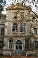 Building of the
Democritus University of Thrace
Building of the
Democritus University of Thrace
There are more than adequate primary and secondary education facilities in the city. There are around 20 primary schools, 7 gymnasia (junior high schools) and 4 lykeia (high schools) as well as the Institute for Vocational Training (
IEK Komotini
). In addition there is 2 technical education institutes (TEE).
Komotini is an established university city in the North of Greece. It is home to the Central Administration and several departments of the
Democritus University of Thrace
including the following:
- Law School
- Physical Education and Sport Sciences
- History and Ethnology
- Greek Literature
- Social Administration
- International Financial Relations and Development
- Business Management (commencing in 2009)
- Politics (commencing in 2009)
- Languages, Literature and Civilization of Black Sea countries
The Komotini campus has a dynamic population of approximately 5?10.000 students and a major part of social life evolves around it. The founding of the University of Thrace in 1973 has had a significant positive influence on the entire urban area fuelling the city's expansion and growth.
The Police Academy is located 7 kilometres (4 miles) from Komotini on the road to Xanthi on extensive grounds and with modern facilities.
Media
[
edit
]
Television
[
edit
]
The main television station based in Komotini is R Channel although other stations broadcast from the city, namely Delta from neighbouring Alexandroupoli and
ET3
(the northern branch of the Hellenic Broadcasting Corporation) from Thessaloniki.
Radio
[
edit
]
The main Radio Stations broadcasting from Komotini are:
- ERA Komotinis (part of the national ERA network, greatest coverage area in N. Greece)
- Radio Paratiritis
- Diavlos Rodopis
- Hit FM
- Joy FM
- Radio Komotini
- Isik FM
- Radio City
Press
[
edit
]
There has been increasing activity in this sector for the last 50 years. There are now 7 daily and 2 weekly active newspapers in the city.
- Paratiritis tis Thrakis (Observer of Thrace): Multilingual (recognised with distinction by the President of The Hellenic Republic for its innovation) politics and culture.
- To Elefthero Vima (Free Standpoint): Politics and culture.
- Thrakiki Agora (Thracian Market): Weekly Politics and Financial news.
- I Paremvasi (Intervention): Politics.
- I Foni tis Rodopis (Voice of Rodopi): Politics.
- Antifonitis (The Opposition): Reactionary Politics, satirical commentary.
- Thrakiki Gi (Thracian Land): Politics and Agricultural News.
- I Patrida (The Homeland): One of the oldest,Politics.
All of the above are paper based. However, there is an increasing volume of news and content that is on the newspapers' websites. The latter can be accessed from the news section of Komotini's commercial portal.
[20]
Transportation
[
edit
]
 The railway station.
Komotini is a midland city and has no port. It is served by two airports. The nearest is in Alexandroupoli (65 km), and the other is in Kavala (80 km).
Highway network
[
edit
]
European route E90
runs through the city and connects Komotini with the other Greek Continental cities. The Egnatia Motorway
(A2)
lies south of the city. One can enter the city from one of two Junctions; 'Komotini West' and 'Komotini East'.
Public transit
[
edit
]
There are a number of municipal buses serving 3 main lines within the city. The Intercity Bus Company of Komotini connects it to many local villages, the coastal areas and major Greek cities.
Railway
[
edit
]
The city is served by
Hellenic Train
, with services running regularly at least twice daily westwards to Thessaloniki and Athens and eastwards to Evros and occasionally Istanbul. The
station
is located outside the city Center.
Sports
[
edit
]
 Panthrakikos
Sports Center
Panthrakikos
Sports Center
There is an impressive array of sports facilities available. They include the
Komotini Municipal Stadium
(Home of Panthrakikos FC), Panthrakiko Stadium (training grounds), Municipal Sports Complex (NE of the city), Municipal Swimming pool and Basketball Arena, Democritus University Sports Complex including an Arena and an Aquatic Centre as well as basketball courts in almost every school in the city. The mountainous area in the north of the city is ideal for mountain-biking and trekking as well as 4x4 racing both of which take place throughout the year.
Historical population
[
edit
]
| Year
|
Town population
|
Municipality population
|
| 1981
|
34,051
|
37,487
|
| 1991
|
37,036
|
39,927
|
| 2001
|
43,326
|
52,659
|
| 2011
|
50,990
|
66,919
|
| 2021
|
51,732
|
65,243
|
Notable people
[
edit
]
- Sadik Achmet
[21]
(Komotini 1947 - Komotini 1995), politician and advocate of Turkish minority rights
- Konstantinos Baniotis
(b.1986), high jumper
[22]
[23]
- Archbishop Chrysanthus of Athens
(
Gratini
1881 - Athens 1949)
- Paschalis Draganidis
(b.1992), footballer
- Frangoulis Frangos
(b. Komotini 1951), general, chief of the
Hellenic Army General Staff
, former
Minister for National Defence
[24]
- Apostolos Grozos
(Komotini 1892 - Bucharest 1981), politician, leader of the
Communist Party of Greece
- Akis Dagazian
(b. Komotini 1975), international relations specialist, economist, businessman, diplomat, Chairman of the Hellenic - Armenian Chamber of Commerce and Industry of Greece (2017-), Consul ad Honorem of the Republic of
Armenia
in
Thessaloniki
(2022-)
[25]
- Hamza Hamzaoglou
(b. Komotini 1970), Turkish footballer
- Hassan Hatipoglou
[
tr
]
(Komotini 1923 - Komotini 2010), Turkish journalist and politician
- Yanko Hristov
[
bg
]
(Komotini 1919 - Bulgaria 1994), Bulgarian partisan and diplomat
- Nikolaos Kaltsas
(b.
Dialambi
[
el
]
near
Iasmos
in
Rhodope
), archaeologist, director of the
National Archaeological Museum, Athens
, member of the
German Archaeological Institute
- Stilpon Kyriakidis
[
el
]
(Komotini 1887 - Thessaloniki 1964), professor of history and folklore culture
[26]
[27]
[28]
[29]
- Petros Mantalos
(b.1991), Greek footballer
- Ioannikios of Maroneia
[
el
]
(d. 1838), cleric, fighter of the
Greek War of Independence
- Nasuh Pasha
(d. 1614), Grand Vizier of the Ottoman Empire
- George Petalotis
(b. Komotini 1964), Greek politician
[30]
- Paul Soulikias
(b. Komotini 1926 ? Larissa 2023), Greek-Canadian painter
- Evripidis Stylianidis
(b.
Maroneia
1966), Greek politician,
Minister of the Interior
in 2012-13
[31]
[32]
[33]
[34]
- Tzavit Tsaglar
(b. Komotini 1944), Turkish businessman and politician
See also
[
edit
]
References
[
edit
]
- ^
Municipality of Komotini, Municipal elections ? October 2023
, Ministry of Interior
- ^
a
b
"Αποτελ?σματα Απογραφ?? Πληθυσμο? - Κατοικι?ν 2021, Μ?νιμο? Πληθυσμ?? κατ? οικισμ?"
[Results of the 2021 Population - Housing Census, Permanent population by settlement] (in Greek). Hellenic Statistical Authority. 29 March 2024.
- ^
a
b
"Visit Greece - ΚΟΜΟΤΗΝΗ"
.
www.visitgreece.gr
.
- ^
D. C. Samsaris, Historical Geography of Western Thrace during the Roman Antiquity (in Greek), Thessaloniki 2005, p. 102
- ^
Kiel, Machiel (1971). "Observations on the History of Northern Greece during the Turkish Rule: Historical and Architectural Description of the Turkish Monuments of Komotini and Serres, their place in the Development of Ottoman Turkish Architecture and their Present Condition".
Balkan Studies
.
12
: 417.
- ^
"Reviving high-rise blocks for cohesive and green neighbourhoods"
(PDF)
.
RE-Block: Baseline Study
.
European Regional Development Fund
. p. 44. Archived from
the original
(PDF)
on 22 October 2013
. Retrieved
24 October
2013
.
- ^
"ΜΟΥΣΟΥΛΜΑΝΙΚΗ ΜΕΙΟΝΟΤΗΤΑ ΘΡΑΚΗΣ"
.
hri.org
.
Archived
from the original on 18 May 2019
. Retrieved
24 March
2018
.
- ^
Messinas, Elias. (2022).
The Synagogues of Greece: A Study of Synagogues in Macedonia and Thrace: With Architectural Drawings of all Synagogues of Greece
. Seattle
ISBN
979-8-8069-0288-8
, pp. 121-131.
- ^
Book (in Hebrew):Bar-Zohar, Michael,
The trains went out empty
, Hed-Artzi, Or-Yhuda, Israel, 1999, page 86.
- ^
Book (in Greek): "Το Ολοκα?τωμα των Ελλ?νων Εβρα?ων ? Μνημε?α και Μν?με?", Κεντρικ? Ισραηλ?τικο Συμβο?λιο Ελλ?δο?, 1st Edition: January 2007,
ISBN
978-960-86029-4-6
, pages 51?56.
- ^
15 March 2010 article in the Greek newspaper Παρατηρητ?? τη? Θρ?κη?: "Το ζ?τημα τη? ιστορ?α? των εβρα?ων τη? Κομοτην?? ξαν? στην επικαιρ?τητα- Με το βιβλ?ο του Θρασ?βουλου Ορ. Παπαστρατ? ≪Απ? τη Γκιουμουλτζ?να στην Τρεμπλ?νκα. Ιστορ?α των Εβρα?ων τη? Κομοτην??≫"
Archived
21 July 2011 at the
Wayback Machine
.
- ^
3 April 2002 article in Greek newspaper ο Χρ?νο?: "Οι Εβρα?οι τη? Κομοτην??: Σημει?ματα Θρασ?βουλου Ορ. Παπαστρατ?".
Archived
10 June 2010 at the
Wayback Machine
- ^
09 April 2010 article in Greek newspaper Παρατηρητ?? τη? Θρ?κη?: "Η ιστορ?α του Σαμπετ?ι και τη? Ντα?ζη απ? την Κομοτην?" του Βασ?λη Ριτζαλ?ου
Archived
21 July 2011 at the
Wayback Machine
.
- ^
"ΦΕΚ A 87/2010, Kallikratis reform law text"
(in Greek).
Government Gazette
.
- ^
"Population & housing census 2001 (incl. area and average elevation)"
(PDF)
(in Greek). National Statistical Service of Greece. Archived from
the original
(PDF)
on 2015-09-21.
- ^
"Detailed census results 1991"
(PDF)
. Archived from
the original
(PDF)
on March 3, 2016.
(39 MB)
(in Greek and French)
- ^
"Komotini Online : Ειδ?σει? και Ν?α απ? τη Ροδ?πη"
.
www.kom.gr
.
- ^
Γιαννακ?δη, Πολιτ?ν Γραφ?? Του Στ?θη (2019-06-11).
"
"Α? μιλ?σουμε ρεαλιστικ? για το ΚΙΕΦ"
"
.
Παρατηρητ?? τη? Θρ?κη?
(in Greek)
. Retrieved
2021-03-22
.
- ^
Θρ?κη?, Παρατηρητ?? τη? (2016-03-20).
"Π?μπτο? στον κ?σμο ο Κ?στα? Μπανι?τη?"
.
Παρατηρητ?? τη? Θρ?κη?
(in Greek)
. Retrieved
2021-03-24
.
- ^
Θρ?κη?, Παρατηρητ?? τη? (2019-03-05).
"Δε?τερο? στην Ευρ?πη ο Κ?στα? Μπανι?τη?"
.
Παρατηρητ?? τη? Θρ?κη?
(in Greek)
. Retrieved
2021-03-24
.
- ^
Θρ?κη?, Παρατηρητ?? τη? (2012-09-27).
"Επ?τιμο? δημ?τη? Ορεστι?δα? θα ανακυρηχθε? ο Φρ?γκο? Φραγκο?λη?"
.
Παρατηρητ?? τη? Θρ?κη?
(in Greek)
. Retrieved
2021-03-23
.
- ^
https://en.armradio.am/2022/04/11/akis-dagazian-appointed-honorary-consul-of-the-republic-of-armenia-to-thessaloniki/
- ^
Θρ?κη?, Παρατηρητ?? τη? (2017-05-15).
"Κεφ?λαιο για τη Θρ?κη και την Ελλ?δα ο Στ?λπων Κυριακ?δη?"
.
Παρατηρητ?? τη? Θρ?κη?
(in Greek)
. Retrieved
2021-03-24
.
- ^
Θρ?κη?, Παρατηρητ?? τη? (2015-01-11).
"Αντιπελ?ργηση Στ?λπων Κυριακ?δη? (1887-1964) - Ο ακ?ματο? "δι?κονο?" στον "αμπελ?να" τη? επιστ?μη?"
.
Παρατηρητ?? τη? Θρ?κη?
(in Greek)
. Retrieved
2021-03-24
.
- ^
Θρ?κη?, Παρατηρητ?? τη? (2020-03-04).
"Η παρακαταθ?κη του σοφο? Κομοτηνα?ου"
.
Παρατηρητ?? τη? Θρ?κη?
(in Greek)
. Retrieved
2021-03-24
.
- ^
Θρ?κη?, Παρατηρητ?? τη? (2021-01-09).
"?να πρωτοποριακ? βιβλ?ο για τον Καραγκι?ζη πριν 100 χρ?νια: Louis Roussel και Στ?λπων Κυριακ?δη?"
.
Παρατηρητ?? τη? Θρ?κη?
(in Greek)
. Retrieved
2021-03-24
.
- ^
Θρ?κη?, Παρατηρητ?? τη? (2013-05-02).
"Γι?ργο? Πεταλωτ??, πρ. υφ. Δικαιοσ?νη?, Διαφ?νεια? και Ανθρωπ?νων Δικαιωμ?των ?λε? οι πολιτικ?? δυν?μει? θα ?πρεπε να συζητο?ν την πρ?ταση για την επ?μενη μ?ρα τη? κρ?ση?"
.
Παρατηρητ?? τη? Θρ?κη?
(in Greek)
. Retrieved
2021-03-23
.
- ^
Θρ?κη?, Παρατηρητ?? τη? (2020-10-17).
"Ο Ευριπ?δη? Στυλιαν?δη? μιλ? για το 12%, τι? προτ?σει? στη Διακομματικ?, τι? τουρκικ?? προκλ?σει?, τη δ?κη τη? ΧΑ"
.
Παρατηρητ?? τη? Θρ?κη?
(in Greek)
. Retrieved
2021-03-24
.
- ^
Θρ?κη?, Παρατηρητ?? τη? (2020-06-04).
"Ευριπ?δη? Στυλιαν?δη?: "Ε?ναι σημαντικ? πρ?τα να ξ?ρουμε εμε?? την ιστορ?α μα?, και σε δε?τερο χρ?νο να ζητ?σουμε αυτ? η ιστορ?α να αρχ?σει να αναδεικν?εται"
"
.
Παρατηρητ?? τη? Θρ?κη?
(in Greek)
. Retrieved
2021-03-24
.
- ^
Βαφει?δου, Νατ?σσα (2021-03-24).
"Τη δ?σμευση του Χ.Θεοχ?ρη για το "?νοιγμα" τη? Νυμφα?α? εξασφ?λισε ο Ευριπ?δη? Στυλιαν?δη?"
.
Παρατηρητ?? τη? Θρ?κη?
(in Greek)
. Retrieved
2021-03-24
.
- ^
Θρ?κη?, Παρατηρητ?? τη? (2020-05-23).
"Λιμενικο?? Σταθμο?? σε Φαν?ρι και Μαρ?νεια διεκδ?κησε ο Ευριπ?δη? Στυλιαν?δη?"
.
Παρατηρητ?? τη? Θρ?κη?
(in Greek)
. Retrieved
2021-03-24
.
Sources
[
edit
]
- Kiel, M. (2004).
"Gumuld?j?ine"
.
The Encyclopedia of Islam, New Edition, Volume XII: Supplement
. Leiden and New York: BRILL. pp. 329?331.
ISBN
978-90-04-13974-9
.
- Messinas, E. (2022).
The Synagogues of Greece: A Study of Synagogues in Macedonia and Thrace: With Architectural Drawings of all Synagogues of Greece
. Seattle: KDP. pp. 121?131 and 167-170.
ISBN
979-8-8069-0288-8
- Μεσσ?να?, Η. (2022).
H Συναγωγ?
, Αθ?να: Εκδ?σει? Ινφογν?μων. pp. 37?46.
ISBN
978-618-5590-21-5
- Μεσσ?να?, Η. (1999).
Oι Συναγωγ?? στην Ελλ?δα, η αρχιτεκτονικ? του? και η σχ?ση του? με τον ιστ? τη? π?λη? και την εβρα?κ? συνοικ?α: Συγκριτικ? μελ?τη τη? ιστορ?α? και αρχιτεκτονικ?? των συναγωγ?ν τη? Βορε?ου Ελλ?δο?, η θ?ση του? στην εβρα?κ? συνοικ?α και η παρουσ?α του? στον πολεοδομικ? ιστ? απ? τον 15ο στον 20ο αι?να.
Διδακτορικ? διατριβ? στο Τμ?μα Αρχιτεκτ?νων Μηχανικ?ν Τομ?α Πολεοδομ?α? και Χωροταξ?α? του ΕΜΠ, pp. 217?238.
External links
[
edit
]
Wikivoyage has a travel guide for
Komotini
.
Wikimedia Commons has media related to
Komotini
.
|
|---|
- Area
- 14,157 km
2
(5,466 sq mi)
- Population
- 608,182 (as of 2011)
- Municipalities
- 22 (since
2011
)
- Capital
- Komotini
|
| Regional unit of
Drama
| | |
|---|
| Regional unit of
Evros
| |
|---|
| Regional unit of
Kavala
| |
|---|
| Regional unit of
Rhodope
| |
|---|
| Regional unit of
Thasos
| |
|---|
| Regional unit of
Xanthi
| |
|---|
|
|
|---|
| International
| |
|---|
| National
| |
|---|
| Geographic
| |
|---|
| Other
| |
|---|