 Kremlin towers in the 19th century
The following is a
list of towers of the
Moscow Kremlin
. The
Kremlin Wall
is a defensive wall that surrounds the
Moscow Kremlin
, recognizable by the characteristic notches and its towers. The original walls were likely a simple wooden fence with guard towers built in 1156. The Kremlin is flanked by 19 towers with a 20th, the Kutafya Tower, not part of its walls.
Borovitskaya
[
edit
]
 Borovitskaya Tower
The
Borovitskaya Tower
(
Russian
:
Боровицкая башня
,
romanized
:
Borovitskaya bashnya
) is a corner tower with a through-passage on the west side of the Kremlin. It is named after
Borovitsky Hill
, one of the
seven hills
Moscow
is standing on. The tower was constructed in 1490 on the spot of an old Kremlin gate by
Italian
architect
Pietro Antonio Solari
(Petr Fryazin, from
fryaz
or
fryag
as Italians were called at that time) by order of
Vasili III of Russia
. In 1658 by orders of
tzar
Aleksey I of Russia
the tower was renamed to
Predtechenskaya
(from the Russian word
предтеча
,
the forerunner
) after the Church of
John the Forerunner
, which was later destroyed during the construction of the
Kremlin Armoury
(
Oruzheynaya Palata
). The new name, however, never became popular. In 1812, the tower was damaged by an explosion staged by the
retreating French army
. In 1817-19, the tower was restored by
architect
Osip Bove
. In 1935, the
Soviets
installed a
red star
on top of the tower. Following the closure of the Spassky Gate in Red Square to all traffic at the end of the 1990s, the Borovitsky Gate became the main vehicle passageway. Together with the star, its height is 54.05 metres (177.3 ft).
Geographical coordinates:
55°44′56″N
37°36′45″E
/
55.748909°N 37.612520°E
/
55.748909; 37.612520
(
Borovitskaya Tower
)
.
Vodovzvodnaya
[
edit
]
 Vodovzvodnaya Tower
The
Vodovzvodnaya Tower
(
Russian
:
Водовзводная башня
,
romanized
:
Vodovzvodnaya bashnya
) is a corner tower on the southwestern side of Kremlin, overlooking the
Moskva River
. It was built in 1488 by an
Italian
architect
Antonio Gilardi
(also known as Anton Fryazin). Initially, the tower was called the Sviblova Tower (Свиблова башня) after the Sviblov
boyar
family, who had lived in a house adjacent to the tower from the Kremlin's side. The tower was renamed to Vodovzvodnaya in 1633 after the installation of a water-supplying machine inside the tower ("vodovzvodnaya" may be translated as "water-lifting"). In 1805, the Vodovzvodnaya Tower was dismantled due to its dilapidation and built once again. In 1812, the retreating
French
army blew it up. The tower was restored in 1817-1819 by architect
Osip Bove
. Its height is 61.85 metres (202.9 ft).
Geographical coordinates:
55°44′53″N
37°36′49″E
/
55.748106°N 37.613647°E
/
55.748106; 37.613647
(
Vodovzvodnaya Tower
)
.
Blagoveschenskaya
[
edit
]
The
Blagoveschenskaya Tower
(
Russian
:
Благовещенская башня
,
romanized
:
Blagoveshchenskaya bashnya
), known in
English
as the
Annunciation Tower
, was erected in 1487-1488. At its foundation are slabs of white
limestone
that have survived since the time of the white stone
Kremlin
of the 14th century. During the reign of
Ivan the Terrible
, the tower was used as a
prison
. The name of the tower comes from the
miracle
-working
Icon of the Annunciation
, which was once kept here, and is also associated with the
Cathedral of the Annunciation
added to the tower in the early 18th century and demolished in 1932. In the 17th century, the Portomoyniye Gates were built nearby so that palace laundresses could go to the Portomoiny raft on the
Moscow River
to rinse porty, or underclothes. These gates were bricked up in 1813.
The height of the tower is 30.7 metres (101 ft) (32.45 metres (106.5 ft) together with the
weather vane
that replaced the original
cross
in 1932).
Geographical coordinates:
55°44′55″N
37°36′55″E
/
55.748722°N 37.615192°E
/
55.748722; 37.615192
(
Blagoveschenskaya Tower
)
.
Taynitskaya
[
edit
]
The
Taynitskaya Tower
(
Russian
:
Тайницкая башня
,
romanized
:
Taynitskaya bashnya
; it was also called
Водяная башня
(
Vodyanaya bashnya
), or the Water Tower) is a middle tower on the south side of the Moscow Kremlin. It was built in 1485 by
Antonio Gilardi
on the spot of the
gates
to
Dmitry Donskoy
's whitestone Kremlin. The Taynitskaya Tower had a secret
well
and a
tunnel
leading to the Moscow River (hence, the name "Taynitskaya", or "secret"). In 1770, the tower was dismantled due to the construction of the
Kremlin Palace
by
Vasili Bazhenov
. It was rebuilt in the 1770s. In 1930-1933, the
Soviets
bricked up the gateway and filled up the well. The Taynitskaya Tower is 38.4 metres (126 ft) in height.
Geographical coordinates:
55°44′58″N
37°37′04″E
/
55.749374°N 37.617863°E
/
55.749374; 37.617863
(
Taynitskaya Tower
)
.
First Unnamed
[
edit
]
The
First Unnamed Tower
(
Russian
:
Первая Безымянная башня
,
romanized
:
Pervaya Bezymyannaya bashnya
) was built next to the Taynitskaya Tower in the 1480s. It performed strictly defensive functions. In 1547, the tower was destroyed by fire after the
gunpowder
stored there exploded, and was rebuilt in the 17th century. In 1770, the tower was taken apart to clear the site for the
Kremlin Palace
. After the construction of the palace ended, the tower was rebuilt in 1783, closer to the Taynitskaya Tower. In 1812, the tower was blown up by
Napoleon’s retreating troops
, but it was soon restored to its original form by
architect
Osip Beauvais
. Its height is 34.15 metres (112.0 ft).
Geographical coordinates:
55°44′58″N
37°37′08″E
/
55.749495°N 37.618968°E
/
55.749495; 37.618968
(
First Unnamed Tower
)
.
Second Unnamed
[
edit
]
The
Second Unnamed Tower
(
Russian
:
Вторая Безымянная башня
,
romanized
:
Vtoraya Bezymyannaya bashnya
) was built in the middle of the 15th century. It had purely defensive functions. In 1680, a
quadrangular
structure and a tall pyramidal tent roof with a
watchtower
were added to the top of the tower. It is crowned with an eight-sided hipped
cupola
with a
weather vane
.
Geographical coordinates:
55°44′59″N
37°37′13″E
/
55.749615°N 37.620363°E
/
55.749615; 37.620363
(
Second Unnamed Tower
)
.
Petrovskaya
[
edit
]
The
Petrovskaya Tower
(
Russian
:
Петровская башня
,
romanized
:
Petrovskaya bashnya
) is named after the Church of
Metropolitan Peter
, which was part of the mission of the
Ugreshi Monastery
located near the tower in the Kremlin. The Petrovskaya Tower was destroyed by
cannon
fire during the
Polish
invasion in 1612 and then restored. In 1771, it was pulled down to construct the
Kremlin Palace
, but was rebuilt in 1783. In 1812, the tower was blown up by
Napoleon’s retreating troops
. In 1818, it was rebuilt by the
architect
Osip Bove
. The Petrovskaya Tower was used as a service building by the Kremlin's
gardeners
. Its height is 27.15 metres (89.1 ft).
Geographical coordinates:
55°44′59″N
37°37′19″E
/
55.749700°N 37.622015°E
/
55.749700; 37.622015
(
Petrovskaya Tower
)
.
Beklemishevskaya
[
edit
]
The
Beklemishevskaya Tower
(
Russian
:
Беклемишевская башня
,
romanized
:
Beklemishevskaya bashnya
, also known as
Москворецкая башня
(
Moskvoretskaya bashnya
), or Moskvoretskaya Tower) is a corner tower on the southeastern side of the Moscow Kremlin on the Moscow River. The tower was built in 1487-1488 by an
Italian
architect
Marco Ruffo
(known as Mark Fryazin in
Russia
). It was named after a boyar
Ivan Bersen-Beklemishev
, whose house had been adjacent to the tower from the Kremlin side. The Beklemishevskaya Tower was constructed for protecting the
ford
and the crossing over the Moscow River. There was the so-called "listening" vault underneath the tower, which was used for preventing the enemy from tunneling his way to the Kremlin. The Beklemishevskaya Tower is 46.2 metres (152 ft) in height. During the
October Revolution
of 1917, the top of the tower was damaged by a shell. It was restored a year later by an architect I.V. Rylsky.
Geographical coordinates:
55°44′59″N
37°37′24″E
/
55.749742°N 37.623239°E
/
55.749742; 37.623239
(
Beklemishevskaya Tower
)
.
Konstantino-Eleninskaya
[
edit
]
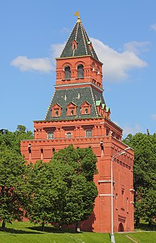 Konstantino-Eleninskaya Tower
The
Konstantino-Eleninskaya Tower
(
Russian
:
Константино-Еленинская башня
,
romanized
:
Konstantino-Eleninskaya bashnya
) is a tower on the eastern wall of the Kremlin, overlooking the so-called
Basil Descent
(Васильевский спуск), which begins at the
Red Square
and ends at the Moscow River. The tower was built in 1490 by an
Italian
architect
Pietro Antonio Solari
on the spot of gates to the whitestone Kremlin. It was named after the Church of Constantine and Helene in the Kremlin (second half of the 17th century), which would be demolished by the
Soviets
in 1928. The Konstantino-Eleninskaya Tower had its own gates and a lift
bridge
, protected by guards at all times. In the late 18th century - early 19th century the gates were bricked up and the bridge was dismantled. The tower's height is 36.8 metres (121 ft).
Geographical coordinates:
55°45′04″N
37°37′20″E
/
55.751179°N 37.622359°E
/
55.751179; 37.622359
(
Konstantino-Eleninskaya Tower
)
.
Nabatnaya
[
edit
]
The
Nabatnaya Tower
(
Russian
:
Набатная башня
) is a tower in the southeastern section of the
Kremlin wall
, built in 1495. It is 38 metres (125 ft) in height. Traditionally, there has always been a
bell
on top of the Nabatnaya Tower, used for notifying citizens of fires and other misfortunes in the Kremlin or on the Red Square (hence, the name Nabatnaya, which derives from the old Russian word
набат
-
nabat
, meaning "alarm" or "tocsin"). In 1680, a bellmaker
Feodor Dmitriev
cast the so-called Nabatny bell (alarm bell) weighing 150
poods
(2.45
metric tons
) and installed it on the tower. The bell subsequently broke and was re-cast by
Ivan Motorin
on 30 July 1714. The sound from this bell served as a signal for the spontaneous uprising of the Muscovites during the
plague
outbreak in 1771, which would later be called the
Plague Riot
(Чумной бунт). By the order of
Catherine the Great
, the tongue of the bell was removed after this incident. The tongueless bell remained on top of the tower for 30 more years. In the early 19th century, it was removed and transferred to the
Arsenal
. In 1821, the bell was moved to the
Armoury
, where it remains to this day in the
vestibule
.
Geographical coordinates:
55°45′07″N
37°37′19″E
/
55.751843°N 37.621908°E
/
55.751843; 37.621908
(
Nabatnaya Tower
)
.
Tsarskaya
[
edit
]
The
Tsarskaya Tower
(
Russian
:
Царская башня
, translated as "Tsar's tower") is the youngest and smallest tower of all, built in 1680. It is not a tower per se, it is rather a stone
terem
, a tent-shaped chamber placed directly on top of the wall. Previously, there was a small wooden
turret
, from which, according to legend,
tsar
Ivan IV
liked to observe what was happening on the Red Square. Hence the name, the Tsar's Tower. The white stone bands around the posts, tall corner pyramids with
gilt
flags and tent roof topped with an elegant gilt
weather vane
make the tower look like some structure from a
fairy tale
.
Geographical coordinates:
55°45′08″N
37°37′18″E
/
55.752284°N 37.621608°E
/
55.752284; 37.621608
(
Tsarskaya Tower
)
.
Spasskaya
[
edit
]
 Clock of the Spasskaya Tower
The Spasskaya Tower was built in 1491 by the
Italian
architect
Pietro Antonio Solari
. Initially, it was named the Frolovskaya Tower after the Church of
Frol and Lavr
in the
Kremlin
, which is no longer there.
[1]
The tower's modern name comes from the icon of 'Spas Nerukotvorny' (
Russian
:
Спас Нерукотворный
) translated as 'The Saviour
Not Made by Hands
', which was placed above the gates on the inside wall in 1658 and removed in 1917. The tower is also named for the wall-painted icon of 'Spas Smolensky' (
Russian
:
Спас Смоленский
) translated as 'Smolensky Saviour', which was created in the 16th century on the outside wall of tower, plastered over in 1937, but reopened and restored in 2010.
The Spasskaya Tower was the first tower of the many Moscow Kremlin Towers to be crowned with the
hipped roof
in 1624?1625 by architects Bazhen Ogurtsov and
Christopher Galloway
(a
Scottish
architect and clock maker).
[2]
According to a number of historical accounts, the
clock
on the Spasskaya Tower appeared between 1491 and 1585. It is usually referred to as the
Kremlin chimes
(Кремлёвские куранты) and designates official Moscow Time. The clock face has a diameter of 6 metres (20 ft).
[3]
The gate of Spasskaya Tower was used to greet foreign dignitaries, and was used during formal ceremonies or processions held on Red Square.
Senatskaya
[
edit
]
The
Senatskaya Tower
(
Russian
:
Сенатская башня
) was built in 1491 by an
architect
Pietro Antonio Solari
and was purely defensive in nature: it guarded the Kremlin on the Red Square side. For a long time it remained nameless. It was only in 1787, after architect
Matvei Kazakov
constructed the
Kremlin Senate
on the Kremlin’s territory, that it was given its present name. The dome of the Senate can be seen from Red Square. Inside the central part of the tower there are three tiers of vaulted chambers. In 1860, the flat tower was topped with a stone tent
roof
crowned, in turn, with a
gilt
weather vane
. The tower contains a through-passage that allows VIPs to travel from the kremlin to Red Square. Its height is 34.3 metres (113 ft).
Geographical coordinates:
55°45′12″N
37°37′10″E
/
55.753449°N 37.619548°E
/
55.753449; 37.619548
(
Senatskaya Tower
)
.
Nikolskaya
[
edit
]
The
Nikolskaya Tower
(
Russian
:
Никольская башня
) is a
tower
with a through-passage on the eastern wall of the Moscow Kremlin, which overlooks the Red Square not far from the
State Historical Museum
.
The Nikolskaya Tower was built in 1491 by an
Italian
architect
Pietro Antonio Solari
. It was named after Nikolaevsky (Nikolsky) Greek Monastery, which is no longer there. In 1806, the tower was rebuilt in the
neo-Gothic style
by an architect
Luigi Rusca
. In 1812, the top of the tower was blown up by the
retreating French army
. It was restored in 1816 by an architect
Osip Bove
. The Nikolskaya Tower was once again severely damaged by the
artillery
fire in October 1917 and was later restored by an architect
Nikolai Markovnikov
. In 1935, the
Soviets
installed a
red star
on top of the tower. Its current height with the star is 70.4 metres (231 ft). The original icon of
Saint Nicholas of Mozhaysk
, placed above the entrance on Red Square had been plastered over by Soviet authorities and was uncovered and restored in 2010 - similar to what took place on the Spasskaya Tower.
[4]
[5]
Geographical coordinates:
55°45′16″N
37°37′04″E
/
55.754421°N 37.617713°E
/
55.754421; 37.617713
(
Nikolskaya Tower.
)
Corner Arsenalnaya
[
edit
]
The
Corner Arsenalnaya Tower
(
Russian
:
Арсенальная Угловая башня
, i.e. "Corner Arsenal tower") is a
tower
of the Moscow Kremlin. It was built in 1492 by an
Italian
architect
Pietro Antonio Solari
. The construction of this tower completed the Kremlin's line of defence from the side of the
Red Square
. It was called the Sobakin Tower until the early 18th century (named so after a boyar Sobakin, whose house had been adjacent to the tower from the Kremlin side). The Corner Arsenalnaya Tower received its current name after the construction of the
Arsenal
. The tower still has a secret
well
. In 1707, due to a threat of
Swedish
invasion, the gun slots of the Corner Arsenalnaya Tower were enlarged to fit heavy
cannons
. In 1812, the tower was damaged by an
explosion
, set up by the
retreating French army
. It was restored in 1816-1819 by architect
Osip Bove
.
The tower's current height is over 60 metres (200 ft).
Geographical coordinates:
55°45′18″N
37°36′59″E
/
55.755110°N 37.616469°E
/
55.755110; 37.616469
(
Corner Arsenalnaya Tower
)
.
Middle Arsenalnaya
[
edit
]
The
Middle Arsenalnaya Tower
(
Russian
:
Средняя Арсенальная башня
, i.e. "Middle Arsenal tower") is a Kremlin tower, built in 1495. It is located on the northwestern side of the Kremlin wall and overlooks the
Alexander Garden
. It is situated on the spot of a corner tower dating from the reign of
Dmitry Donskoi
. It was given its present name, the Middle Arsenal Tower, after the
Arsenal
was completed in the mid-18th century. Originally, it was called the Faceted Tower because of the shape of its
facade
. In 1680, an open lookout with a small
pyramid
-shaped top was added to the tower. In 1821, when the Alexander Garden was laid out, an ancient-style
grotto
was built at the foot of the tower, designed by
Osip Bove
.
Geographical coordinates:
55°45′13″N
37°36′56″E
/
55.753667°N 37.615525°E
/
55.753667; 37.615525
(
Middle Arsenalnaya Tower
)
.
Troitskaya
[
edit
]
The
Troitskaya Tower
was built in 1495?1499 by an
Italian
architect
Aloisio da Milano
(known in
Russia
as
Aleviz Fryazin Milanets
). The tower has borne several names, including Rizopolozhenskaya, Znamenskaya, and Karetnaya. It received its current name in 1658 from the Troitskaya
Coaching Inn
(Троицкое подворье) in the Kremlin. The two-story basement of the tower housed a
prison
in the 16th?17th centuries. There is the Troitsky Bridge, which is protected by the Kutafia Tower and leads to the gates of the Troitskaya Tower. There was also a
clock
on top of the tower between 1585 and 1812. In 1707, due to a threat of
Swedish
invasion, the gun slots of the Troitskaya Tower were enlarged to fit heavy
cannons
. In 1935, the
Soviets
installed a
red star
on top of the Troitskaya Tower. Prior to Soviet rule the tower had an icon of the Holy Trinity atop its outward face. Because this tower was the formal entrance for huge Communist Party Congresses the icon was totally removed rather than just plastered over as were those on the Spasskaya and Nikolskaya Towers.
Komendantskaya
[
edit
]
The
Komendantskaya Tower
(
Russian
:
Комендантская башня
) was completed in 1495. It used to be called
Kolymazhnaya
after the Kremlin’s
coach
yard, where
carriages
and coaches had been kept. It was given its present name, the
Commandant
’s Tower, in the 19th century when the commandant of Moscow took up residence in the Kremlin’s Poteshny ? or Amusement ? Palace. Like all Kremlin towers, it was supplemented with a tent
roof
and
watchtower
in 1676-1686. The height of the tower on the side of the
Alexander Garden
is 41.25 metres (135.3 ft).
Geographical coordinates:
55°45′02″N
37°36′49″E
/
55.750575°N 37.613518°E
/
55.750575; 37.613518
(
Komendantskaya Tower
)
.
Oruzheynaya
[
edit
]
 Oruzheynaya Tower
The
Oruzheynaya Tower
(
Russian
:
Оружейная башня
, translated as Armory Tower) was built in 1495. It was given its present name in the 19th century after the construction of the
Armory
. Before then, it was known as the
Konyushennaya Tower
, a reference to the royal
stables
that stood behind it.
Geographical coordinates:
55°44′58″N
37°36′46″E
/
55.749428°N 37.612714°E
/
55.749428; 37.612714
(
Oruzheynaya Tower
)
.
Kutafya
[
edit
]
The
Kutafya Tower
(
Russian
:
Кутафья башня
formerly
Predmostnaya
tower) is an outlying
barbican
tower of the Moscow Kremlin. Built in 1516 under the leadership of the Milanese architect
Aloisio da Milano
, in order to protect one end of the
Neglinnaya River
bridge that comes out of the West side of the Kremlin wall under the Troitskaya Tower. Initially, the Kutafya was surrounded by a
moat
and was the only access to the city through its lift bridge, nowadays the moat around the bridge has transformed into
Alexander Garden
. Kutafya is one of the lower height Kremlin towers which had two combat
tiers
and no spire, with the open-top upper landing equipped with
arrowslits
and
machicolations
, which made it a formidable obstacle to the besieging of the Kremlin fortress.
Marking today the main public entrance to the Kremlin, the Kutafya tower was modified several times through the centuries:
- in the 16th and 17th centuries, a system of
dikes
was built to raise the water level of the Neglinnaya river and create a moat that surrounded the tower from all sides, making its
drawbridge
the only entry point from the city;
- In 1668 a causeway leading through the tower to the Troitskaya Bridge was built;
- a delicate ornamental crown in the
Muscovite baroque
style was built in 1685;
- the divider between the two tiers was destroyed in 1780;
- in 1867, a through-passage to the Manezhnaya Street was built as well as the arched apertures on the sides and a guard house on the south side;
- the guard house was dismantled during the restoration works of carried out in 1974-77.
The Kutafya Tower is currently 13.5 m high; it used to be 18 m but the lower part of the tower was "submerged" by successive constructions that heightened the street-level ground.
Geographical coordinates:
55°45′09″N
37°36′46″E
/
55.752514°N 37.612649°E
/
55.752514; 37.612649
(
Kutafya Tower
)
.
References
[
edit
]
External links
[
edit
]
|
|---|
Kremlin Wall
and
Towers
| |
|---|
Administrative
buildings
| |
|---|
| Churches
| |
|---|
Squares
and gardens
| |
|---|
| Monuments
| |
|---|
| Former
| |
|---|